Layout 1 (Page 2) - Midpeninsula Regional Open Space District
Layout 1 (Page 2) - Midpeninsula Regional Open Space District
Layout 1 (Page 2) - Midpeninsula Regional Open Space District

Create successful ePaper yourself
Turn your PDF publications into a flip-book with our unique Google optimized e-Paper software.
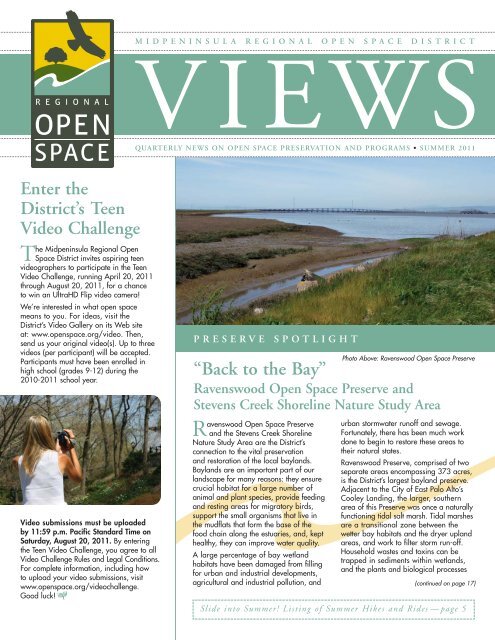
Enter the<br />
<strong>District</strong>’s Teen<br />
Video Challenge<br />
The <strong>Midpeninsula</strong> <strong>Regional</strong> <strong>Open</strong><br />
<strong>Space</strong> <strong>District</strong> invites aspiring teen<br />
videographers to participate in the Teen<br />
Video Challenge, running April 20, 2011<br />
through August 20, 2011, for a chance<br />
to win an UltraHD Flip video camera!<br />
We’re interested in what open space<br />
means to you. For ideas, visit the<br />
<strong>District</strong>’s Video Gallery on its Web site<br />
at: www.openspace.org/video. Then,<br />
send us your original video(s). Up to three<br />
videos (per participant) will be accepted.<br />
Participants must have been enrolled in<br />
high school (grades 9-12) during the<br />
2010-2011 school year.<br />
Video submissions must be uploaded<br />
by 11:59 p.m. Pacific Standard Time on<br />
Saturday, August 20, 2011. By entering<br />
the Teen Video Challenge, you agree to all<br />
Video Challenge Rules and Legal Conditions.<br />
For complete information, including how<br />
to upload your video submissions, visit<br />
www.openspace.org/videochallenge.<br />
Good luck!<br />
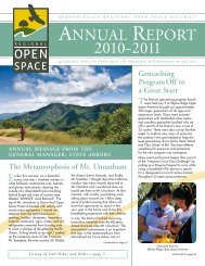
MIDPENINSULA REGIONAL OPEN SPACE DISTRICT<br />
VIEWS<br />
QUARTERLY NEWS ON OPEN SPACE PRESERVATION AND PROGRAMS • SUMMER 2011<br />
PRESERVE SPOTLIGHT<br />
“Back to the Bay”<br />
Ravenswood <strong>Open</strong> <strong>Space</strong> Preserve and<br />
Stevens Creek Shoreline Nature Study Area<br />
Ravenswood <strong>Open</strong> <strong>Space</strong> Preserve<br />
and the Stevens Creek Shoreline<br />
Nature Study Area are the <strong>District</strong>’s<br />
connection to the vital preservation<br />
and restoration of the local baylands.<br />
Baylands are an important part of our<br />
landscape for many reasons: they ensure<br />
crucial habitat for a large number of<br />
animal and plant species, provide feeding<br />
and resting areas for migratory birds,<br />
support the small organisms that live in<br />
the mudflats that form the base of the<br />
food chain along the estuaries, and, kept<br />
healthy, they can improve water quality.<br />
A large percentage of bay wetland<br />
habitats have been damaged from filling<br />
for urban and industrial developments,<br />
agricultural and industrial pollution, and<br />
Photo Above: Ravenswood <strong>Open</strong> <strong>Space</strong> Preserve<br />
urban stormwater runoff and sewage.<br />
Fortunately, there has been much work<br />
done to begin to restore these areas to<br />
their natural states.<br />
Ravenswood Preserve, comprised of two<br />
separate areas encompassing 373 acres,<br />
is the <strong>District</strong>’s largest bayland preserve.<br />
Adjacent to the City of East Palo Alto’s<br />
Cooley Landing, the larger, southern<br />
area of this Preserve was once a naturally<br />
functioning tidal salt marsh. Tidal marshes<br />
are a transitional zone between the<br />
wetter bay habitats and the dryer upland<br />
areas, and work to filter storm run-off.<br />
Household wastes and toxins can be<br />
trapped in sediments within wetlands,<br />
and the plants and biological processes<br />
(continued on page 17)<br />
Slide into Summer! Listing of Summer Hikes and Rides —page 5
Karl Gohl<br />
A MESSAGE FROM THE GENERAL MANAGER<br />
Strategies<br />
Nature always has something interesting and new to teach us; lessons about the fellow creatures<br />
that inhabit this blue planet and life in general. When I think back to the summers of my<br />
boyhood, I recall endless vignettes of encounters with some bird, lizard or insect that held my<br />
fascination then, and still does today. The pale swallowtail, a large off-white butterfly with black<br />
stripes that we often see in the woodlands, is one of my favorite examples.<br />
The life history of the pale swallowtail is a strategic masterpiece. The small, off-white egg that is laid<br />
on the leaf of the coffeeberry hatches into a caterpillar that perfectly mimics a bird dropping. Who<br />
would want to eat that? The caterpillar soon molts into a pale green stage that is camouflaged to the<br />
precise color of the coffeeberry. It weaves a transparent silk pad in the middle of the leaf where it<br />
sits motionless most of the day. To feed, it purposefully crawls several branches away so that the leaf<br />
damage it creates, which can visually attract predators, will be some distance from its resting place. If, perchance, it is disturbed, it will<br />
suddenly expose large eyespots on the top of its thorax and extend foul-smelling, yellow osmetria – fleshy glands that pop out from an<br />
area in the back of its head when startled or threatened. This display is often enough to startle and deter a predator. As the weeks pass,<br />
the larva grows until, one day it suddenly vanishes from its silk pad, traveling at the blinding speed of ninety feet per hour. It then finds<br />
a safe horizontal surface such as the underside of a branch, very near the ground, where<br />
it pupates into a chrysalis that is even more difficult to locate than the caterpillar. Unless it<br />
is detected by a parasitic wasp or fly, it will emerge as an adult butterfly and the cycle will<br />
repeat itself. In the life of this insect, we observe a variety of adaptive strategies, executed<br />
with precision, ensuring the success of this<br />
species in an environment full of obstacles.<br />
Pale Swallowtail Butterfly,<br />
Rancho San Antonio <strong>Open</strong> <strong>Space</strong> Preserve<br />
As I turn my attention from the woodlands to<br />
the office, I think about the <strong>District</strong>’s future in<br />
a similar way. While we have depended on<br />
property tax from the Silicon Valley area for<br />
the past forty years to fund our activities, the<br />
challenges of this “new economy” demand<br />
that we explore new options for funding<br />
and partnering to broaden our “suite of<br />
strategies” so that we can secure the<br />
remaining unprotected open space lands in public ownership and expand our ability to<br />
bring sensitive stewardship and public access to lands we already own. As we develop<br />
and test these options as part of our Strategic Planning Process,* we would like to<br />
hear from you. I invite you to share your ideas with us, either via our Web site at<br />
www.openspace.org, contact us at info@openspace.org, or at the meetings of our Board of Directors that are held the second and<br />
fourth Wednesday of every month at 7:00 p.m. While the strategies we develop with your help will certainly be different from those<br />
used by the pale swallowtail, our goal – to ensure success in an environment full of obstacles – is really the same.<br />
Stephen E. Abbors<br />
General Manager<br />
* Strategic Planning Process<br />
Using a planning process developed by David La Piana, the <strong>District</strong> is identifying current opportunities and challenges and strategizing<br />
how to address them in a way that best fulfills the <strong>District</strong>’s mission. Steps include articulating the <strong>District</strong>’s identity, creating strategic<br />
decision making criteria, and developing, testing, implementing, and evaluating new strategies. The real-time strategic planning<br />
process is designed to allow the <strong>District</strong> to respond and adapt to unforeseen changes and circumstances through time.<br />
BOARD OF DIRECTORS<br />
Pete Siemens ◆ Ward 1 (Cupertino, Los Gatos, Monte Sereno, Saratoga) ◆ Yoriko Kishimoto ◆ Ward 2 (Cupertino, Los Altos, Los Altos Hills, Palo Alto, Stanford, Sunnyvale)<br />
Jed Cyr ◆ Ward 3 (Sunnyvale) ◆ Curt Riffle ◆ Ward 4 (Los Altos, Mountain View) ◆ Nonette G. Hanko ◆ Ward 5 (East Palo Alto, Menlo Park, Palo Alto, Stanford)<br />
Larry Hassett ◆ Ward 6 (Atherton, Menlo Park, Pescadero, Portola Valley, Redwood City, San Gregorio, Woodside)<br />
Cecily Harris ◆ Ward 7 (El Granada, Half Moon Bay, Montara, Moss Beach, Redwood City, San Carlos, Woodside)<br />
Stephen E. Abbors ◆ General Manager ◆ Kristi Britt ◆ <strong>Open</strong> <strong>Space</strong> Views Editor ◆ Renée Fitzsimons ◆ Outdoor Activities Editor<br />
2<br />
Coffeeberry,<br />
Sierra Azul <strong>Open</strong> <strong>Space</strong> Preserve<br />
Pale Swallowtail Larva,<br />
Rancho San Antonio <strong>Open</strong> <strong>Space</strong> Preserve<br />
Tom Cochrane
CONTEST WINNERS<br />
Third (2010) Digital Photo Contest Winners<br />
Thanks to all who participated last year in the <strong>District</strong>’s Third Annual Digital Photo Contest! Our third contest was a huge<br />
success, yielding over 700 entries (roughly equal to the entries for the first and second contests combined). Please join us<br />
in congratulating the winners.<br />
Grand Prize<br />
Winner:<br />
Vaibhav Tripathi<br />
Grand Prize Includes:<br />
• Admission for two on Oceanic<br />
Society’s Whale-watching<br />
Cruise in Half Moon Bay<br />
• A Flip UltraHD camcorder<br />
• $50 dining certificate<br />
• Reserved copy of the<br />
<strong>District</strong>’s coffee table book<br />
(release date: fall 2012)<br />
“Light-beam Scattering”<br />
Windy Hill <strong>Open</strong> <strong>Space</strong> Preserve<br />
3rd Prize<br />
Winner:<br />
Bing Huey<br />
2nd Prize<br />
Winner:<br />
Ichiro Asao<br />
3rd Prize Includes:<br />
• Admission for four to Filoli<br />
House and Garden<br />
• <strong>District</strong> messenger bag<br />
• Local cheese gift basket<br />
Further view the winning photos, along with other contest finalists, in their full splendid glory at: www.openspace.org/contest.<br />
3<br />
“Wildflowers Dance on a Windy Evening at Sunset”<br />
Russian Ridge <strong>Open</strong> <strong>Space</strong> Preserve<br />
2nd Prize Includes:<br />
• Admission for four to a<br />
production by Theatre<br />
in the Woods<br />
• $50 dining certificate<br />
• CJ Olson Cherries gift box<br />
• <strong>District</strong> travel blanket<br />
“Banana Slug Over Twig”<br />
Purisima Creek Redwoods <strong>Open</strong> <strong>Space</strong> Preserve
WORKING FOR OPEN SPACE<br />
<strong>District</strong> staff and volunteers who work to preserve and protect natural and cultural resources<br />
Cindy Roessler, Senior Resource Management Specialist<br />
<strong>District</strong> preserves are loaded with natural resources: plants<br />
and animals – both common and rare – watersheds,<br />
and fragile ecosystems, and Senior Resource Management<br />
Specialist Cindy Roessler plays a vital role in their restoration<br />
and protection. (Natural resource management protects, restores,<br />
enhances, and monitors native vegetation and wildlife, and their<br />
geological setting.)<br />
Since she was a small child in<br />
Florida, Cindy’s passions have been<br />
rooted outdoors. One day her father<br />
handed her a seed catalogue, and<br />
she was amazed by all the types of<br />
flowers. She subsequently followed<br />
her parents’ interest in science by<br />
studying ecology at New College<br />
of Florida. After graduating, Cindy<br />
worked for several years for a local<br />
agency where she managed island<br />
beaches and monitored sea turtles.<br />
In 1984, Cindy moved to California<br />
and worked as a biological consultant<br />
before she was employed by the Santa<br />
Clara Valley Water <strong>District</strong> where she<br />
was responsible for restoring natural conditions along creeks.<br />
Cindy came to the <strong>Midpeninsula</strong> <strong>Regional</strong> <strong>Open</strong> <strong>Space</strong> <strong>District</strong> in<br />
2002 as the single resource management staff in the Operations<br />
department, and now oversees two Resource Specialists, a<br />
Natural Resource Intern, and a Special Project Coordinator.<br />
Visiting a preserve with Cindy exposes one to the searching eyes<br />
and inquisitive mind of a biologist. A shrubby hillside to Cindy<br />
is evidence of prior agricultural use and changes over the past<br />
100 years. She can distinguish the non-native from native grasses,<br />
and the wildflowers and weeds<br />
battling for the remaining ground.<br />
Cindy and the resource management<br />
staff work closely with <strong>District</strong> field<br />
staff and volunteers on the removal<br />
of non-native, invasive plants. The<br />
goal is to restore the land to a<br />
condition of high native biodiversity.<br />
Cindy gets the natural processes<br />
working again to let the land heal.<br />
Cindy enjoys working with dedicated<br />
field staff, many with educational<br />
backgrounds and interest in biology.<br />
She calls them “practical ecologists.”<br />
Asked how she knows if her work is<br />
successful, she gives an example of<br />
the increase in badger digs that she<br />
spots throughout Los Trancos, Monte Bello, and Russian<br />
Ridge <strong>Open</strong> <strong>Space</strong> Preserves. Badgers are easily disturbed<br />
and displaced by habitat loss and the preserves have allowed<br />
them to slowly re-establish. Cindy also measures success by the<br />
Cindy Roessler, Senior Resource Management Specialist<br />
Why Cindy Came Out West and Stayed;<br />
Skyline Ridge <strong>Open</strong> <strong>Space</strong> Preserve<br />
4<br />
devotion and enthusiasm of volunteers. She takes pride in<br />
educating volunteers and helping them connect their work to<br />
the natural qualities of the land.<br />
With nearly 60,000 acres of land to care for, the question of<br />
prioritization often arises. Sometimes the answer for Cindy lies<br />
in where the work can get the “biggest bang for the buck.” Los<br />
Trancos Preserve has the highest<br />
diversity of native grasses Cindy has<br />
seen in the Santa Cruz Mountains,<br />
and, therefore, it’s been a logical<br />
and rewarding location to concentrate<br />
on the control of non-native<br />
yellow starthistle.<br />
Other resource management<br />
programs moving along under<br />
Cindy’s lead are: eradication of<br />
slender false brome, a destructive<br />
weed currently found only in<br />
Thornewood <strong>Open</strong> <strong>Space</strong><br />
Preserve and the surrounding<br />
town of Woodside; responding<br />
to sudden oak death which has<br />
been affecting oak and tanoak<br />
trees throughout coastal California and Oregon; grassland<br />
management; and conservation grazing.<br />
When Cindy is not working, she spends her time exploring<br />
the natural world around her. She currently lives at Big Dipper<br />
Ranch located in a closed area of Skyline Ridge <strong>Open</strong> <strong>Space</strong><br />
Preserve. (Two major landslides contributed to this area being<br />
closed; recently obtained grant funds will allow the repair of<br />
these slides to begin this summer.) Cindy says that living in<br />
a preserve and witnessing the changes that occur season<br />
by season have given her more<br />
intimate knowledge of the land.<br />
She has started writing a natural<br />
history blog to share stories and<br />
photographs of this wild spot in<br />
the Santa Cruz Mountains.<br />
There are many issues and<br />
choices for the <strong>District</strong>’s Resource<br />
Management Program, including<br />
balancing a wide range of competing<br />
priorities. In her role, Cindy<br />
finds it important to “give people<br />
the confidence that we’re not just<br />
buying the land, we are caring<br />
for it.”<br />
To learn more about the <strong>District</strong>’s<br />
Resource Management and Volunteer Programs, please visit<br />
the <strong>District</strong>’s Web site at:<br />
• www.openspace.org/plans_projects/resource_management.asp<br />
• www.openspace.org/volunteer
WHAT’S THE DIRT?<br />
Sound Bites of Summer<br />
Many sounds are associated with summer – children splashing in a lake; katydids droning in the<br />
afternoon heat; waves crashing on a beach; bats chirping overhead in search of mosquitoes;<br />
Stellar’s jays chattering as you picnic; wind blowing through the trees… times remembered and<br />
memories made – summer sounds enrich our time outdoors.<br />
When you are out for a summer stroll along a preserve trail, listen for some of the myriad creatures<br />
that may be communicating around you. Animals could be defending territories, sending out alarms<br />
that predators are near, searching for mates, or protecting young. You may hear: vultures scream;<br />
badgers growl; frogs croak; beetles drone; foxes simper; owls shriek-hoot-screech; mosquitoes<br />
whine; rabbits drum; coyotes yelp; swallows twitter; raccoons chitter; falcons chant; and bitterns<br />
boom. Animal sounds are described in unusual terms!<br />
One of the more familiar late-evening sounds during the summer is the rhythmic chirping of a male<br />
cricket. A.E. Dolbear, a professor of physics at Tufts College, first noted the relationship between<br />
ambient temperature and the rate that a cricket chirps. Crickets chirp faster as temperatures rise<br />
and slower when temperatures fall.<br />
With this newsletter in hand and a sense of exploration in mind,<br />
we invite you to enjoy the <strong>Midpeninsula</strong> <strong>Regional</strong> <strong>Open</strong> <strong>Space</strong><br />
<strong>District</strong> preserves. These 26 extraordinary preserves include nearly<br />
60,000 acres of permanently protected open space, from redwood<br />
forests to bay shoreline. We encourage you to participate in the wide<br />
variety of adventures offered inside Outdoor Activities. The activity<br />
durations listed are averages based on our experience. However,<br />
always allow extra time in your schedule for unusual circumstances,<br />
or the slower pace of some groups. You can help by arriving a little<br />
early to ensure a prompt start for each activity.<br />
GENERAL INFORMATION<br />
ACTIVITY GUIDELINES<br />
To ensure that your experience is enjoyable, please review this important information:<br />
• Please be courteous to other trail users. Stay alert and make your<br />
presence known to other trail users well in advance, particularly<br />
when approaching from behind.<br />
• Hikers yield to horses; bicyclists yield to hikers and horses.<br />
Observe trail speed limits (15 mph max; 5 mph when passing).<br />
• Equestrians must provide their own horses (no stallions or rental<br />
horses). Lead lines are required and breast collars are recommended<br />
for all horses, and helmets must be worn by all riders under age 18.<br />
• Heavy rain within two days prior to a mountain bike or horseback<br />
ride cancels the activity.<br />
MIDPENINSULA REGIONAL OPEN SPACE DISTRICT<br />
OUTDOOR<br />
ACTIVITIES<br />
5<br />
SUMMER 2011 • JUNE– JULY– AUGUST<br />
Richard Kumaishi<br />
Great Horned Owlets,<br />
Fremont Older <strong>Open</strong> <strong>Space</strong> Preserve<br />
(continued on page 14)<br />
The activities are free, though some require reservations. Heavy rain<br />
cancels the activity unless otherwise noted in the description. If there<br />
is light rain or the threat of rain, go to the meeting place.<br />
All programs are led by docents who have completed a <strong>District</strong> training<br />
program. These docents volunteer their time to share their knowledge<br />
of nature with you. For more information about the volunteer docent<br />
program, visit the <strong>District</strong>’s Web site at www.openspace.org, or phone<br />
the <strong>District</strong> at 650-691-1200 weekdays, 8:30 a.m.– 5:00 p.m.<br />
• For all hikes, wear boots or sturdy walking shoes appropriate<br />
for rugged trails.<br />
• Dress in layers (T-shirt, long-sleeved shirt, sweater and/or jacket).<br />
The weather can be unpredictable. No matter what season it is,<br />
be prepared for rain, wind, fog, or sun!<br />
• Carry ample water with you to drink. Water is not available<br />
on preserves.<br />
• Bring sun protection (hat, sunscreen) and insect repellent.<br />
• Restrooms are not always available; please plan accordingly.
DANIELS NATURE CENTER<br />
Park at the Russian Ridge Preserve parking<br />
lot on the northwest corner of the Skyline<br />
Boulevard (Highway 35) and <strong>Page</strong> Mill/<br />
Alpine Road intersection (across Skyline Blvd.<br />
on the right). Walk to Alpine Pond at Skyline<br />
Ridge Preserve by going through the tunnel<br />
under Alpine Rd. The Nature Center is a<br />
small gray building on the east shore of<br />
Alpine Pond.<br />
EDGEWOOD COUNTY PARK<br />
From I-280, exit Edgewood Road. Drive 1<br />
mile on Edgewood Rd. toward San Carlos/<br />
Redwood City. Turn right into the park<br />
entrance (at Old Stagecoach Road).<br />
EL CORTE DE MADERA CREEK<br />
Meet at Skeggs Point, a Caltrans vista point<br />
on the east side of Skyline Boulevard, about<br />
4 miles north of La Honda Road (Highway<br />
84) and 1.5 miles south of Kings Mountain<br />
Road. Please note that Caltrans prohibits a<br />
left turn into the lot when approaching from<br />
the north along Skyline Blvd.<br />
FREMONT OLDER<br />
Meet at the Preserve parking lot on Prospect<br />
Road in Cupertino. Exit Highway 85 at De<br />
Anza Boulevard. (From northbound 85 turn<br />
left on De Anza Blvd. and from southbound<br />
85 turn right on De Anza Blvd.) Travel on De<br />
Anza Blvd. (toward the mountains) for about<br />
0.5 miles. Turn right on Prospect Rd. At the<br />
first stop sign, turn left and cross the railroad<br />
tracks to remain on Prospect Rd. Follow<br />
Prospect Rd. for 1.3 miles, turning left after<br />
the Saratoga Country Club, until you reach<br />
the Preserve parking lot.<br />
LONG RIDGE<br />
Meet at the Grizzly Flat trailhead on the west<br />
side of Skyline Boulevard 3.6 miles north of<br />
Highway 9, or 3.3 miles south of <strong>Page</strong> Mill<br />
Road. If you are coming from the north on<br />
Skyline Blvd., the pullout is just past Portola<br />
Heights Road on the right. From the south,<br />
the pullout is near the Palo Alto city limits<br />
sign on the right.<br />
LOS TRANCOS<br />
Meet at the Preserve parking lot on <strong>Page</strong><br />
Mill Road (across from Monte Bello Preserve),<br />
7 miles west of I-280 or 1.5 miles east of<br />
Skyline Boulevard. Those traveling from I-280<br />
on <strong>Page</strong> Mill Rd. should allow approximately<br />
35 minutes travel time.<br />
OUTDOOR ACTIVITIES • Summer 2011<br />
Where To Meet<br />
Directions to preserves featured in this season’s schedule of Outdoor Activities are listed below. Some preserves have more than one access point.<br />
Some activities meet at different locations than where the activity will actually occur. If an activity does not meet at the preserve listed, or if there<br />
is more than one preserve access point, the alternate meeting location will be indicated in italics on a separate line following the preserve name<br />
as part of the activity header. (For example: Skyline Ridge Meet: Russian Ridge or Russian Ridge Meet: Caltrans vista point). If no<br />
information follows the preserve name, then refer to the detailed directions for the preserve or alternate meeting location listed below.<br />
PLEASE CHECK THE LISTED DESCRIPTION TO MAKE SURE YOU MEET YOUR ACTIVITY LEADER AT THE CORRECT LOCATION.<br />
MONTE BELLO<br />
Meet at the Preserve parking lot on <strong>Page</strong><br />
Mill Road (across from Los Trancos Preserve),<br />
7 miles west of I-280 or 1.5 miles east of<br />
Skyline Boulevard. Those traveling from I-280<br />
on <strong>Page</strong> Mill Rd. should allow approximately<br />
35 minutes travel time.<br />
PICCHETTI RANCH<br />
From the intersection of I-280 and Foothill<br />
Expressway, go 3.5 miles southwest (toward<br />
the mountains) on Foothill Boulevard/Stevens<br />
Canyon Road. Turn right on Montebello<br />
Road. The Preserve is 0.5 miles up<br />
Montebello Rd. on the left.<br />
PULGAS RIDGE<br />
From I-280, exit Edgewood Road. Drive<br />
0.75 miles on Edgewood Rd. toward San<br />
Carlos/Redwood City. Turn left (north) on<br />
Crestview Drive, then immediately turn left on<br />
Edmonds Road. Follow Edmonds Rd. to the<br />
Preserve parking lot entrance on the right.<br />
PURISIMA CREEK REDWOODS<br />
Whittemore Gulch entrance: This entrance is<br />
on Skyline Boulevard next to the now closed<br />
Kings Mountain Country Store. The parking<br />
lot is 4.5 miles south of Highway 92, and<br />
8.1 miles north of Highway 84.<br />
Purisima Creek Road entrance: From the<br />
Highway 92 and Highway 1 intersection in<br />
Half Moon Bay, travel south on Highway 1<br />
approximately 4.3 miles. Turn left on Verde<br />
Road. After turning on Verde Rd. and traveling<br />
0.25 miles, continue straight to remain on<br />
what becomes Purisima Creek Road. (Verde<br />
Rd. splits off to the right.) Travel approximately<br />
3.7 miles on Purisima Creek Rd. to reach<br />
the Preserve.<br />
RANCHO SAN ANTONIO<br />
From I-280, take Foothill Boulevard south and<br />
turn right almost immediately onto Cristo Rey<br />
Drive. Continue about 1 mile, veer right around<br />
the traffic circle, and turn left into the park.<br />
Go to the lot farthest to the right and meet<br />
near the restroom at the bottom of the hill.<br />
RUSSIAN RIDGE<br />
Meet at the Preserve parking lot on the<br />
northwest corner of the Skyline Boulevard<br />
(Highway 35) and <strong>Page</strong> Mill/Alpine Road<br />
intersection (across Skyline Blvd. on the right).<br />
Those traveling from I-280 on <strong>Page</strong> Mill Rd.<br />
should allow approximately 35 minutes<br />
travel time.<br />
6<br />
Jack Owicki<br />
El Corte de Madera Creek <strong>Open</strong> <strong>Space</strong> Preserve<br />
SARATOGA GAP<br />
Meet at the Caltrans vista point on the<br />
southeast corner of the Skyline Boulevard<br />
(Highway 35) and Highway 9 intersection.<br />
SIERRA AZUL<br />
Meet at the parking lot located near the<br />
intersection of Hicks Road and Mt. Umunhum<br />
Road in San Jose. Exit Highway 85 at<br />
Camden Avenue. (From northbound<br />
Hwy. 85 turn left on Branham Avenue and<br />
then turn left on Camden Ave. and from<br />
southbound Hwy. 85 turn left on Camden<br />
Ave.) Travel on Camden Ave. about 1.6<br />
miles. Turn right on Hicks Rd. and travel for<br />
about 6.3 miles. Turn right on Mt. Umunhum<br />
Rd. The Preserve parking lot will be on<br />
the right.<br />
SKYLINE RIDGE<br />
Meet at the Preserve parking lot on Skyline<br />
Boulevard located one mile south of the <strong>Page</strong><br />
Mill/Alpine Road and Skyline Blvd. (Highway<br />
35) intersection. After entering the Preserve,<br />
turn right and go to the farthest parking lot.<br />
Those traveling from I-280 on <strong>Page</strong> Mill Rd.<br />
should allow approximately 40 minutes<br />
travel time.<br />
Equestrian parking lot: After entering the<br />
Preserve, proceed to the farthest parking lot<br />
on the left. Those traveling from I-280 on<br />
<strong>Page</strong> Mill Rd. should allow approximately<br />
40 minutes travel time.
Easy Hike: Flat to gently rolling<br />
hills. Total elevation gain less<br />
than 200 feet. Leisurely pace.<br />
Moderate Hike: Steeper or<br />
more frequent uphill grades.<br />
Total elevation gain 200 to 600<br />
feet. Leisurely to moderate pace.<br />
Strenuous Hike: Steep hills<br />
and/or long distances. Total<br />
elevation gain greater than 600<br />
feet. Moderate to vigorous pace.<br />
Bring a lunch, dinner, or snack<br />
as appropriate.<br />
OUTDOOR ACTIVITIES • Summer 2011<br />
Easy Nature Ride: Slow,<br />
leisurely pace, minimal climbing,<br />
and multiple stops to observe nature.<br />
Introductory Mountain Bike<br />
Ride: Outings include demonstration<br />
and practice emphasizing trail<br />
etiquette and techniques required<br />
for dirt riding followed by a 5- to<br />
7-mile ride on fire roads and singletrack<br />
trails, with occasional natural<br />
history stops. Riders should be in<br />
good physical condition to perform<br />
climbs and descents.<br />
ST. JOSEPH’S HILL<br />
Take Highway 17 south toward Los Gatos.<br />
Exit at Highway 9-Los Gatos/Saratoga and<br />
continue west on Hwy. 9 (approximately<br />
0.33 miles) to University Avenue. Turn<br />
left on University Ave. toward downtown<br />
Los Gatos. Turn left on Miles Avenue and<br />
proceed two blocks to the parking lot<br />
on the left for the Little League field.<br />
Key to Symbols<br />
Reservations Required:<br />
Reservations for activities requiring<br />
them will only be accepted within the<br />
two (2)-week period just before the<br />
activity date. To make a reservation or<br />
a cancellation, visit the <strong>District</strong>’s Web<br />
site www.openspace.org/reservations<br />
or call 650-691-2150 (enter Option<br />
2). If you provide information prior<br />
to the reservation acceptance period,<br />
it will not be processed. Please limit<br />
your reservation to a maximum of<br />
four (4) people.<br />
Suitable for children; must be<br />
accompanied and supervised by<br />
an adult. See the activity descriptions<br />
for any age recommendations.<br />
Intermediate Mountain Bike<br />
Ride: Intended for participants with<br />
dirt single track riding experience;<br />
able to climb and descend steep and<br />
moderately-rough trails. Recreational<br />
ride at a moderate/brisk pace, 8+<br />
miles on a wide range of fire roads<br />
and single-track trails. For experienced<br />
riders in very good physical<br />
condition with good endurance.<br />
Wheelchair accessible.<br />
Stroller accessible. Jogger-type<br />
suggested.<br />
Well behaved and socialized dogs<br />
are allowed, and must be controlled<br />
on a maximum six-foot leash.<br />
Equestrian ride. Riders under age<br />
18 must wear a helmet. Lead lines<br />
are required and breast collars are<br />
recommended for horses. Equestrians<br />
must provide their own horses<br />
(no stallions or rental horses).<br />
Advanced Mountain Bike Ride:<br />
Intended for participants with dirt<br />
single track riding experience;<br />
competent at climbing and descending<br />
steep and rough trails. Moderate to<br />
fast pace, 10+ mile ride on a wide<br />
variety of trail conditions. For<br />
experienced riders with a high<br />
level of physical fitness and<br />
excellent endurance.<br />
For all rides, bicyclists must wear helmets and bikes must be in good condition, and the<br />
participants must be very familiar with the operation of gears and brakes. Mountain bikes<br />
are strongly recommended for all except the Easy Nature Rides. Easy Nature, Introductory,<br />
and Intermediate Rides include a natural history component that is provided by the docents<br />
during the rest stops. Advanced rides develop and improve mountain bike skills – any<br />
natural history discussion stops are secondary to the overall riding experience.<br />
Where To Meet<br />
(continued from page 6)<br />
THORNEWOOD<br />
From Highway 280 in Woodside, take the<br />
Highway 84/Woodside Road exit. Follow<br />
Highway 84/Woodside Road through<br />
Woodside and then to a junction with Portola<br />
Road at 3.3 miles. Bear right to stay on<br />
Highway 84, now La Honda Road. At 4.9<br />
miles from Highway 280, turn left at a brick<br />
wall marked 895-897; look for the <strong>District</strong><br />
sign just inside this gate. The small parking<br />
area is on the right about 500 feet from the<br />
entrance gate. Please do not drive beyond<br />
this lot toward the private residences.<br />
Special Note:<br />
7<br />
THORNEWOOD (continued)<br />
Alternatively, from the junction of Highway<br />
35 (Skyline Boulevard) and Highway 84 in<br />
Sky Londa, take Highway 84/La Honda<br />
Road north 1.9 miles and turn right<br />
at the brick<br />
wall marked<br />
895-897.<br />
Illustration by<br />
Robert Moncrieff<br />
If you have a group of 8 or more people who would like to attend a docent-led activity listed here, please contact the Docent Programs<br />
Coordinator to discuss in advance at 650-691-1200 or docent@openspace.org. Other arrangements may need to be considered for your group.
JUNE<br />
Wednesday • June 1<br />
Sierra Azul<br />
10:30 am – 2:00 pm<br />
“Explorer Hike”<br />
Enjoy the warmth of early summer along the<br />
base of Mt. Umunhum. Join docents Lynn<br />
Jackson, Ida Rhodes, and Elaine Rossignol<br />
for a leisurely exploration of wildflowers<br />
and animal sign (tracks, scat, scrapes, nests,<br />
bones, feathers, etc.) during a 5.5-mile hike<br />
on the Woods Trail.<br />
Saturday • June 4<br />
Monte Bello<br />
10:00 am – 1:30 pm<br />
“Water Music”<br />
Join docents Keith Johnsgård and Ann<br />
Reisenauer on this 3-mile loop down through<br />
grasslands and forests into the beautiful<br />
Stevens Creek riparian corridor. You’ll ford<br />
a shallow creek on exposed rocks, and then<br />
stop for lunch at a hushed and shaded<br />
streamside spot with live water music. This<br />
is a leisurely walk along the Canyon and<br />
Stevens Creek Nature Trails with a 300-foot<br />
elevation gain return trip.<br />
Saturday • June 4<br />
Long Ridge<br />
10:00 am – 2:00 pm<br />
“Grizzly Adams in<br />
San Francisco?”<br />
James Capen Adams with his “Mountaineer<br />
Museum” was the hit of San Francisco during<br />
the 1850s. Walk with docents Ida Rhodes<br />
and Ed Lange on this 7-mile, moderatelypaced<br />
excursion to learn about this character<br />
of the old west and his friendly grizzlies,<br />
Lady Washington and Samson. You’ll travel<br />
along Peters Creek and Long Ridge Trails with<br />
a brief stop for lunch and reflection at the<br />
Wallace Stegner bench.<br />
Saturday • June 4<br />
Monte Bello<br />
6:00 pm – 10:30 pm<br />
“Encounters of the<br />
Nocturnal Kind”<br />
Discover night’s natural wonders with<br />
docents Debbi Brusco, Jack Owicki, and<br />
Jan Hintermeister. You’ll hike about 4 miles<br />
at a leisurely to moderate pace on the<br />
Canyon and Indian Creek Trails, with stops<br />
for interesting sights and sounds. Bring a<br />
flashlight with a red cellophane covering or<br />
filter, your packed meal, and plastic to sit on.<br />
Reservations are required and will be<br />
accepted on or after May 19.<br />
OUTDOOR ACTIVITIES • Summer 2011<br />
Saturday and Sunday<br />
June 4 and 5<br />
Daniels Nature Center<br />
12:00 noon – 5:00 pm<br />
”Stop In and Explore”<br />
A summer outing awaits you…bring family<br />
and friends to visit the Daniels Nature Center<br />
on Saturdays and Sundays this summer<br />
between 12:00 noon and 5:00 pm. You can<br />
enjoy displays about natural communities,<br />
view larger-than-life pond strata mobiles,<br />
take a pond prowl, study live aquatic organisms<br />
“borrowed” from Alpine Pond with the<br />
assistance of a docent, or enjoy a picnic with<br />
your companions on nearby tables (pack out<br />
your own trash please!). The living is easy –<br />
come and see!<br />
Bay Area Ridge Trail,<br />
Russian Ridge <strong>Open</strong> <strong>Space</strong> Preserve<br />
Sunday • June 5<br />
Purisima Creek Redwoods<br />
Meet: Whittemore<br />
Gulch entrance<br />
10:00 am – 2:00 pm<br />
“Peaks and Creeks Ride”<br />
Ride the creek canyons and open-view, singletrack<br />
trails of this beautiful Preserve on your<br />
mountain bike with docents Dave Kocsis and<br />
Collin Lim. This intermediate/advanced-level<br />
ride begins with a short road ride and then<br />
drops steeply from Skyline Boulevard through<br />
redwood forests along Purisima Creek. You’ll<br />
then climb back under deep forest shade to<br />
a ridge with a sweeping view of the Pacific<br />
Ocean before returning to your starting point.<br />
The total distance will be about 9.75 miles<br />
with approximately 1,500 feet of climbing.<br />
Reservations are required and will be<br />
accepted on or after May 19.<br />
8<br />
Frank Crossman<br />
Sunday • June 5<br />
Skyline Ridge<br />
Meet: Russian Ridge<br />
11:00 am – 1:30 pm<br />
“Hiking 101”<br />
New to hiking? Your questions and apprehensions<br />
will be addressed by docents Ed Lange<br />
and Cathy Brown on this leisurely 3-mile<br />
hike. You’ll discuss safety, hiking equipment,<br />
where and who to hike with, and have any<br />
questions answered concerning day hiking in<br />
this area. This short hike will conclude with a<br />
tour of the Daniels Nature Center for anyone<br />
interested. Bring a snack and a smile.<br />
Sunday • June 5<br />
Los Trancos<br />
2:00 pm – 4:30 pm<br />
“Earthquake Walk”<br />
Join docents Dave and Judy Boore for a<br />
fun and educational hike along the San<br />
Andreas Fault. On this 2- to 3-mile stroll,<br />
you’ll discuss the wonder of plate tectonics,<br />
examine remnants left by thousands of major<br />
earthquakes, and learn how to prepare for<br />
future earthquakes.<br />
Wednesday • June 8<br />
Saratoga Gap<br />
10:00 am – 12:00 noon<br />
“Scenic Aerobic Hike”<br />
Summer weather awaits you most days with<br />
cool beginnings and warm endings. Docents<br />
Stella Yang and Bernie Larkin are waiting<br />
too, for you to join them on a 3- to 5-mile<br />
hike at a <strong>District</strong> preserve – you’ll enjoy<br />
minimal stops combined with a moderate<br />
pace to keep the scenic aerobic mantra.<br />
Thursday • June 9<br />
Long Ridge<br />
10:00 am – 2:00 pm<br />
“Search for Lemonade Springs”<br />
Join docents Tommi and Strether Smith<br />
on their continuing search for the fabled<br />
Lemonade Springs. This 6-mile hike will<br />
explore the beautiful Peters Creek and Long<br />
Ridge Trail areas. You’ll lunch at the Stegner<br />
Bench with ocean views and tales about environmentalist<br />
and author Wallace Stegner. The<br />
hike will be at a moderate pace with a climb<br />
of about 600 feet.<br />
Friday • June 10<br />
Edgewood County Park<br />
6:00 pm – 7:30 pm<br />
“TGIF Sunset Hike”<br />
Join docents Robin and Les Wrigley for a<br />
5-mile sunset hike around Edgewood County<br />
Park. You’ll hike the Sylvan Trail to admire the<br />
wildflowers, then cross the Serpentine Loop<br />
Trail, and return downhill on the Edgewood<br />
Trail. There will be an optional dinner<br />
with your hiking companions at a local<br />
restaurant afterward.
Saturday • June 11<br />
El Corte de Madera Creek<br />
9:30 am – 1:00 pm<br />
“History of Logging Ride”<br />
Explore this historic logging area via bike<br />
with docents Linda and Glen Wegner. You’ll<br />
travel along the Blue Blossom, Crosscut,<br />
Manzanita, and other trails for this 10- to 12mile,<br />
advanced level mountain bike ride with<br />
over 3,500 feet of climbing. Riders must have<br />
experience with technical single-track trails<br />
and fire roads. Bring water, a power snack,<br />
and layers for possible foggy/cool weather.<br />
Saturday • June 11<br />
Long Ridge<br />
10:00 am – 1:30 pm<br />
“Ohlone Medicine”<br />
Native Americans, including California<br />
Indians, had a great number of uses for the<br />
plants growing on their lands – a primary<br />
use was medicinal. Join docents Sarah<br />
Schoen and Judy Fenerty on this 5-mile hike<br />
exploring the Peters Creek and Long Ridge<br />
Trails, with a lunch stop overlooking the<br />
western slopes of the Santa Cruz Mountains.<br />
Learn ways that selected native plants were<br />
used to treat a number of ailments before the<br />
introduction of modern medicine.<br />
Saturday and Sunday<br />
June 11 and 12<br />
Daniels Nature Center<br />
12:00 noon – 5:00 pm<br />
“Stop In and Explore”<br />
(Please see the activity description for June 4.)<br />
Wednesday • June 15<br />
Saratoga Gap-Long Ridge<br />
Meet: Saratoga Gap<br />
10:30 am – 2:00 pm<br />
“Explorer Hike”<br />
Enjoy two preserves on one hike and avoid<br />
the summer heat with docents Ida Rhodes,<br />
Elaine Rossignol, and Lynn Jackson. You’ll<br />
explore the woodlands and meadows on a<br />
leisurely 4-mile loop trip along the Saratoga<br />
Gap and Achistaca Trails in the Saratoga<br />
Gap and Long Ridge <strong>Open</strong> <strong>Space</strong> Preserves.<br />
Thursday • June 16<br />
Long Ridge-Saratoga Gap<br />
Meet: Long Ridge<br />
10:00 am – 4:00 pm<br />
“Exploring the Ridge”<br />
Grasslands, woods, a pond, a creek, coastal<br />
views – diversity abounds on this 12-mile,<br />
2,000-foot gain trek on the Long Ridge,<br />
Hickory Oaks, Achistaca, Saratoga Gap,<br />
and Peters Creek Trails in the Santa Cruz<br />
Mountains. Docents Fran Keeler and<br />
Ranjana Sharma will explore with you<br />
the fascinating discoveries found along<br />
myriad trails in two preserves.<br />
OUTDOOR ACTIVITIES • Summer 2011<br />
Saturday • June 18<br />
Monte Bello-Los Trancos<br />
Meet: Los Trancos<br />
10:00 am – 1:00 pm<br />
“The San Andreas Fault”<br />
Hear the remarkable story of how California<br />
slowly emerged from the sea during North<br />
America’s 200 million year westward voyage,<br />
how the San Andreas Fault took form, and<br />
how thousands of subsequent earthquakes<br />
shaped the fault landscape that you’ll traverse.<br />
Docents Keith Johnsgård and Ida Rhodes will<br />
lead this 3-mile outdoor moving classroom<br />
geared for adults. No young children please.<br />
Reservations are required and will be<br />
accepted on or after June 2.<br />
Saturday and Sunday<br />
June 18 and 19<br />
Daniels Nature Center<br />
12:00 noon – 5:00 pm<br />
“Stop In and Explore”<br />
(Please see the activity description for June 4.)<br />
Sunday • June 19<br />
Monte Bello<br />
10:00 am – 2:00 pm<br />
“Learning the Landscape”<br />
Join docents Dave Kocsis and Martin Manley<br />
to see how the motion of the San Andreas<br />
Fault has shaped the Santa Cruz Mountains,<br />
left some evidence behind, and helped to<br />
create a variety of natural communities. On<br />
this 6-mile, moderately-paced hike via Bella<br />
Vista, Canyon, Skid Road, and Stevens Creek<br />
Nature Trails, you’ll descend into Stevens<br />
Canyon, meander along Stevens Creek<br />
through a nice mixed evergreen forest,<br />
and then ascend Black Mountain for a<br />
commanding view of the entire South Bay<br />
and the Santa Cruz Mountains.<br />
Sunday • June 19<br />
Purisima Creek Redwoods<br />
Meet: Whittemore<br />
Gulch entrance<br />
10:00 am – 2:00 pm<br />
“Sunday with the Old Giants”<br />
Explore the less-visited southwestern slopes<br />
of this Preserve with docents Mary Bernstein<br />
and John Wertzler on a 6.5-mile, moderatelypaced<br />
hike along Bald Knob, Irish Ridge,<br />
and Lobitos Creek Trails. On a clear day,<br />
you’ll have a grand view – if it’s foggy, you’ll<br />
experience fog drip first hand. You’ll come<br />
face-to-face with some forest giants and, with<br />
luck, find the delicate harebells in bloom.<br />
You’ll enjoy lunch somewhere amid the big<br />
trees. (Note: Participants will carpool to a<br />
trailhead with limited roadside parking.)<br />
Reservations are required and will be<br />
accepted on or after June 2.<br />
9<br />
Strether Smith<br />
Sunday • June 19<br />
Picchetti Ranch<br />
10:30 am – 3:00 pm<br />
“Search for the Everlasting”<br />
Join docents Bob Segalla, Harry Cornbleet,<br />
and Greg Azevedo to share the finest things in<br />
life so close to home. On this leisurely-paced,<br />
4-mile hike with a couple of 200-foot climbs,<br />
a lovely view awaits you along the Orchard<br />
Loop and Zinfandel Trails. The sound of Stevens<br />
Creek will engage you as you enjoy lunch at a<br />
Santa Clara County Park picnic area, and by<br />
the end of the hike you can decide if the everlasting<br />
plant smells like maple syrup to you.<br />
Capable children are welcome on this outing.<br />
A visit to Picchetti Winery for wine tasting is<br />
optional (on your own) at the hike’s end.<br />
Wednesday • June 22<br />
St. Joseph’s Hill<br />
10:00 am – 12:00 noon<br />
“Scenic Aerobic Hike”<br />
(Please see the activity description for June 8.)<br />
Friday • June 24<br />
Rancho San Antonio<br />
10:00 am – 3:00 pm<br />
“PG&E Trail Trek”<br />
Join docents Robin and Les Wrigley on the<br />
challenging PG&E Trail. You’ll enjoy some<br />
lovely forests, creeks, and bay views during<br />
this vigorously-paced, 8-mile hike with a<br />
1,000+ foot elevation gain.<br />
Saturday • June 25<br />
Miramontes Ridge<br />
Meet: See text below<br />
10:00 am – 2:00 pm<br />
“Explore Miramontes Ridge”<br />
Docents Judy Fenerty and Steve Warner<br />
welcome the opportunity to explore this limitedaccess<br />
Preserve with you on a 3- to 4-mile<br />
excursion to the historic home site of Gilcrest<br />
Ranch. Enjoy wonderful views of the coast, and<br />
learn about the area’s history and watershed<br />
values. This is a moderately-paced uphill hike,<br />
with a downhill return on unimproved trails.<br />
Reservations are required and will be<br />
accepted on or after June 9. Directions to<br />
the meeting location will be e-mailed or<br />
snail-mailed to you.<br />
Miramontes Ridge <strong>Open</strong> <strong>Space</strong> Preserve
Saturday and Sunday<br />
June 25 and 26<br />
Daniels Nature Center<br />
12:00 noon – 5:00 pm<br />
“Stop In and Explore”<br />
(Please see the activity description for June 4.)<br />
Sunday • June 26<br />
Purisima Creek Redwoods<br />
Meet: Whittemore Gulch entrance<br />
10:00 am – 1:00 pm<br />
“Ride Purisima Canyon”<br />
Come spend the morning on horseback amid<br />
redwoods and ferns with docents Lyndall Erb<br />
and Jenny Whitman for a ride down and<br />
up the Purisima Canyon. This 10-mile ride<br />
explores a favorite area for those who like to<br />
see a variety of flora and fauna. Horses need<br />
to be conditioned for steady climbs up fire<br />
roads. No stallions. (Note: This activity is<br />
designed for equestrians who have their<br />
own horse; horses are not provided.) Trailer<br />
parking is limited. Reservations are required<br />
and will be accepted on or after June 9.<br />
Sunday • June 26<br />
Skyline Ridge<br />
Meet: Russian Ridge<br />
11:00 am – 2:00 pm<br />
“Focus on Kids”<br />
Docents Keith Johnsgård and Ann Reisenauer<br />
will tell your kids all about nature on this fun,<br />
2-mile hike (accompanying parents permitted<br />
to listen while the kids engage!). You’ll visit<br />
a hidden Indian grotto, a pond, and deep<br />
forest. After climbing a hill to see the world<br />
below, you’ll finish at the interactive Daniels<br />
Nature Center for a visit and picnic by<br />
Alpine Pond. Activity best suited for children<br />
ages 8-11.<br />
Thursday • June 30<br />
El Corte de Madera Creek<br />
10:00 am – 3:00 pm<br />
“Summer Shade”<br />
Escape the sun and heat of the lowlands with<br />
an exploration of trails and old logging roads<br />
in the cool and shady depths of this Preserve.<br />
Docents Fran Keeler, Ranjana Sharma, and<br />
Lou Wolner will guide you through the<br />
elaborate trail network of the Preserve on<br />
this 10-mile, 2,200-foot gain trek along the<br />
Sierra Morena, Steam Donkey, Blue Blossom,<br />
Lawrence Creek, Gordon Mill, and Timberview<br />
Trails. (Note: Participants will carpool to a<br />
trailhead with limited roadside parking.)<br />
OUTDOOR ACTIVITIES • Summer 2011<br />
JULY<br />
Saturday • July 2<br />
Skyline Ridge-Long Ridge<br />
Meet: Skyline Ridge<br />
equestrian parking lot<br />
10:00 am – 2:00 pm<br />
“Ridge Cruise”<br />
Docents Strether Smith, David Kocsis,<br />
and Earl Girbovan will lead you on an<br />
intermediate bike ride that mixes moderate<br />
climbs and descents with lots of sightseeing<br />
along Peters Creek Trail and throughout the<br />
Long Ridge and Skyline Ridge Preserve areas.<br />
Riders will cover about 10 miles and climb a<br />
total of about 1,000 feet as they enjoy several<br />
of the Bay Area’s best overlooks. Suitable for<br />
riders 14 years of age and older who are<br />
comfortable on single-track trails and moderately<br />
steep hills. Reservations are required<br />
and will be accepted on or after June 16.<br />
Saturday • July 2<br />
Purisima Creek Redwoods<br />
Meet: Purisima Creek<br />
Road entrance<br />
10:00 am – 5:00 pm<br />
“Big Redwood Loop”<br />
Big trees call for a big hike. Docents Paul<br />
Billig and Sarah Schoen will lead you on this<br />
exploration through redwood groves and<br />
other habitats. The 9.5-mile hike will have an<br />
elevation gain of 1,300 feet. You’ll begin with<br />
a hike up the Purisima Creek Trail. Following<br />
a lunch stop among redwoods along the<br />
Craig Britton Trail, you’ll continue up the<br />
Harkins Ridge Trail for a second stop at a<br />
vista point. You’ll descend back down on the<br />
North Ridge Trail and into more redwoods<br />
along the Whittemore Gulch Trail. Be sure to<br />
bring plenty of water to cover this time and<br />
distance. Reservations are required and will<br />
be accepted on or after June 16.<br />
10<br />
Summer Nature Days<br />
Don’t miss out on amazing fun for ages 5 to 10 years old !<br />
Join the <strong>District</strong> and Santa Clara Valley Audubon Society (SCVAS) for nature<br />
exploration extraordinaire – discover bugs, birds, creeks, trees, and more, using<br />
crafts, games, and other activities.<br />
Several sessions to choose from – select one day or all three:<br />
July 26 @ Picchetti Ranch Preserve (9am-2pm), July 27 @ Rancho San Antonio<br />
Preserve (10am-2pm), or July 28 @ McClellan Ranch Park (10am-2pm). All locations<br />
are near Cupertino. A modest registration fee is required. For details and information<br />
go online at www.scvas.org or call 408-252-3740.<br />
Saturday and Sunday<br />
July 2 and 3<br />
Daniels Nature Center<br />
12:00 noon – 5:00 pm<br />
“Stop In and Explore”<br />
(Please see the activity description for<br />
June 4.)<br />
Sunday • July 3<br />
Los Trancos<br />
2:00 pm – 4:30 pm<br />
“Earthquake Walk”<br />
(Join docents Paul Billig and Liz Farnsworth,<br />
and please see the activity description for<br />
June 5.)<br />
Friday • July 8<br />
Pulgas Ridge<br />
6:00 pm – 7:30 pm<br />
“TGIF Sunset Hike”<br />
Start off the weekend right with a<br />
fast-paced, 4- to 5-mile walk with<br />
docents Robin and Les Wrigley. You’ll<br />
traverse through woodland, chaparral,<br />
and grasslands along the Preserve’s<br />
major trails. There will be an optional<br />
dinner with your hiking companions<br />
at a local restaurant afterward.<br />
Saturday • July 9<br />
El Corte de<br />
Madera Creek<br />
10:00 am – 2:00 pm<br />
“Exploring ECdeM”<br />
Explore the shaded forests and challenging<br />
single-track trails of this beautiful Preserve<br />
on your mountain bike with docents Dave<br />
Kocsis and Patty Lovelace. This intermediate/advanced<br />
level ride drops steeply from<br />
Skyline Boulevard through mixed evergreen<br />
and redwood forests to El Corte de Madera<br />
Creek, 800 feet below, then climbs back to<br />
a vista point with a sweeping view toward<br />
the Pacific before returning to your starting<br />
point. The total distance will be about<br />
10 miles with more than 2,000 feet of<br />
climbing. Reservations are required and<br />
will be accepted on or after June 23.
Saturday and Sunday<br />
July 9 and 10<br />
Daniels Nature Center<br />
12:00 noon – 5:00 pm<br />
“Stop In and Explore”<br />
(Please see the activity description for<br />
June 4.)<br />
Sunday • July 10<br />
Thornewood<br />
10:00 am – 12:00 noon<br />
“Strolling to the Pond”<br />
Docents Kandis Scott and Mike Alexander<br />
will lead you on a leisurely 3-mile stroll<br />
into this Preserve and walk part way on<br />
the new Bridle Trail to explore this area.<br />
On the return hike, you’ll stop for lunch<br />
at peaceful Schilling Lake and enjoy the<br />
shade of mature trees.<br />
Sunday • July 10<br />
Skyline Ridge<br />
Meet: Russian Ridge<br />
10:00 am – 1:00 pm<br />
“The Ohlone Way”<br />
Docents Keith Johnsgård and Ida Rhodes<br />
will lead this leisurely 2-mile walk along<br />
the Butano View and Ipiwa Trails with<br />
stops to discuss useful plants. Lunch will<br />
feature a 1-hour talk on the history of<br />
humans in North America and Skyline<br />
Ridge. This hike is geared for adults.<br />
No young children please. Reservations<br />
are required and will be accepted on or<br />
after June 23.<br />
Friday • July 15<br />
Monte Bello<br />
6:00 pm – 10:30 pm<br />
“Sunlight to Moonlight”<br />
Join docents Paul Billig and Katherine<br />
Greene on an evening walk in Monte Bello<br />
Preserve. As you enjoy the dinner you<br />
bring atop Black Mountain, sunlight will<br />
give way to moonlight when the full moon<br />
rises after sunset. This 5-mile hike will<br />
have an elevation gain of about 800 feet.<br />
Reservations are required and will be<br />
accepted on or after June 30.<br />
Saturday • July 16<br />
El Corte de Madera Creek<br />
9:30 am – 1:00 pm<br />
“History of Logging Ride”<br />
(Please see the activity description<br />
for June 11.)<br />
OUTDOOR ACTIVITIES • Summer 2011<br />
Saturday • July 16<br />
Skyline Ridge<br />
10:00 am – 1:30 pm<br />
“Lions and Us”<br />
Join docents Keith Johnsgård and Adda<br />
Quinn on a 4-mile natural history hike<br />
through beautiful Skyline Ridge Preserve.<br />
During a 1-hour lunch, Johnsgård, a mountain<br />
resident, will talk about lion encounters with<br />
humans to illustrate the basic guidelines for<br />
safe travel in lion country. This hike and<br />
discussion are not appropriate for children.<br />
Reservations are required and will be<br />
accepted on or after June 30.<br />
Dragonflies, Skyline Ridge <strong>Open</strong> <strong>Space</strong> Preserve<br />
Saturday and Sunday<br />
July 16 and 17<br />
Daniels Nature Center<br />
12:00 noon – 5:00 pm<br />
“Stop In and Explore”<br />
(Please see the activity description for June 4.)<br />
Sunday • July 17<br />
Skyline Ridge<br />
10:00 am – 1:00 pm<br />
“Natural Communities<br />
Sampler: Summer”<br />
Experience the grasslands, chaparral, mixed<br />
evergreen forests, and riparian natural<br />
communities of Skyline Ridge Preserve in<br />
the summer with docents John Wertzler,<br />
Cathy Brown, and Madeline Brane. On<br />
this moderately-paced, 3- to 4-mile hike on<br />
the Sunny Jim Trail and other trails around<br />
Horseshoe Lake, you’ll get to observe plants<br />
and animals adapting to the dry seasonal<br />
changes. Come take pictures and capture the<br />
essence of natural communities in the summer.<br />
Return in the fall or another time of year to<br />
see what a difference a season makes. Hike<br />
may be repeated quarterly. No lunch break<br />
planned; pack a snack if you like.<br />
11<br />
Strether Smith<br />
Sue Copeland<br />
Wednesday • July 20<br />
Long Ridge<br />
10:30 am – 2:00 pm<br />
“Explorer Hike”<br />
Docents Elaine Rossignol and Lynn Jackson<br />
will lead you on a moderate 4- to 5-mile<br />
hike to enjoy the shaded woods and terrific<br />
vistas available at Long Ridge Preserve.<br />
A specific route will be chosen based on<br />
weather conditions.<br />
Saturday • July 23<br />
Skyline Ridge<br />
9:30 am – 12:00 noon<br />
“Discovering Dragonflies”<br />
Docents Karen DeMello and Jan Hintermeister<br />
will introduce you to the fascinating world<br />
of dragonflies on this 2-mile hike around<br />
Horseshoe Lake. On the first part of the walk,<br />
you’ll learn the basics of dragonfly biology<br />
and behavior. Then you’ll observe and try to<br />
identify these interesting insects near the lake.<br />
Bring binoculars if you have them.<br />
Saturday • July 23<br />
Skyline Ridge<br />
11:00 am – 3:30 pm<br />
“A View of Life”<br />
Check out young oak trees planted by <strong>District</strong><br />
volunteers as part of a restoration project.<br />
Docents Bob Segalla and Lou Wolner will<br />
guide you on this excursion that includes<br />
visiting Alpine Pond via the Ipiwa Trail, and<br />
Horseshoe Lake via the Ridge Trail to explore<br />
and understand the preservation of our local<br />
”greenbelt.” This moderately-paced, 4-mile<br />
hike has a 400-foot elevation change and is<br />
suitable for capable children.<br />
Saturday and Sunday<br />
July 23 and 24<br />
Daniels Nature Center<br />
12:00 noon – 5:00 pm<br />
“Stop In and Explore”<br />
(Please see the activity description for June 4.)<br />
Rancho San Antonio <strong>Open</strong> <strong>Space</strong> Preserve
Sunday • July 24<br />
Skyline Ridge-Russian<br />
Ridge-Coal Creek-<br />
Monte Bello<br />
Meet: Skyline Ridge<br />
9:30 am – 2:00 pm<br />
“Tour de <strong>Open</strong> <strong>Space</strong>”<br />
Join docents Patty Lovelace and Mike<br />
Bradshaw for a ride encompassing a four<br />
preserve circuit of Skyline Ridge, Russian<br />
Ridge, Coal Creek, and Monte Bello<br />
Preserves. Get a taste of what each of the<br />
Preserves has to offer while meandering up<br />
and down (approximately 2,000 feet of total<br />
climbing – depending on the group’s wishes)<br />
through them all. The ride will be a highintermediate<br />
level ride, about 12 miles total<br />
distance on fire roads and single track,<br />
and with a small bit of pavement riding.<br />
Reservations are required and will be<br />
accepted on or after July 7.<br />
Sunday • July 24<br />
Skyline Ridge -Russian<br />
Ridge-Monte Bello<br />
Meet: Skyline Ridge<br />
equestrian parking lot<br />
10:00 am – 1:00 pm<br />
“Ride the Ridges”<br />
Join docents Lyndall Erb and Jenny Whitman<br />
for an enjoyable 10-mile ride on a route to<br />
be determined by weather, number of riders,<br />
and interests of the group – with three<br />
preserves and many trails, a great ride is<br />
definite. Horses need to be conditioned for<br />
steady climbs up fire roads. No stallions.<br />
(Note: This activity is designed for equestrians<br />
who have their own horse; horses are not<br />
provided.) Reservations are required and<br />
will be accepted on or after July 7.<br />
Thursday • July 28<br />
Skyline Ridge<br />
9:00 am – 12:00 noon<br />
“Summer on the Ridge”<br />
Discover the beauty and diversity of Skyline<br />
Ridge Preserve with docents Fran Keeler and<br />
Ranjana Sharma on this 6-mile, 1,100-foot<br />
gain, moderately-paced loop hike. You’ll enjoy<br />
panoramic views and learn of the many plant<br />
communities in this diverse Preserve, including<br />
woodland, grassland, chaparral, and aquatic.<br />
A repeat of this hike is planned for fall, winter,<br />
and spring to observe seasonal changes.<br />
Saturday • July 30<br />
Skyline Ridge<br />
Meet: Russian Ridge<br />
11:00 am – 2:00 pm<br />
“Focus on Kids”<br />
(Join docents Keith Johnsgård and Christina<br />
Petitt, and please see the activity description<br />
for June 26.)<br />
OUTDOOR ACTIVITIES • Summer 2011<br />
Yellow Bush Lupine,<br />
Purisima Creek Redwoods <strong>Open</strong> <strong>Space</strong> Preserve<br />
Saturday • July 30<br />
Purisima Creek Redwoods<br />
Meet: Purisima Creek<br />
Road entrance<br />
11:30 am – 2:00 pm<br />
“Beating the Heat”<br />
To hide from the heat, you can take shelter<br />
in the redwoods on this leisurely stroll led<br />
by docents Kandis Scott and Mike Alexander.<br />
You’ll look closely at the redwood trees along<br />
the creek on this 2.5-mile out-and-back walk.<br />
The time is set to avoid beach traffic but,<br />
because there is not a practical lunch spot, be<br />
sure to bring walk-along snacks. Reservations<br />
are required and will be accepted on or<br />
after July 14.<br />
Saturday and Sunday<br />
July 30 and 31<br />
Daniels Nature Center<br />
12:00 noon – 5:00 pm<br />
“Stop In and Explore”<br />
(Please see the activity description for June 4.)<br />
Sunday • July 31<br />
Los Trancos<br />
10:00 am – 2:00 pm<br />
“Geocaching Family Fun”<br />
This fun and interactive hike is great for<br />
families and children (that can hike for 3 to<br />
4 miles). Join docents Bill Overall, Christina<br />
Petitt, and REI Outdoor School Navigation<br />
instructor Steve Wood to search for ”geocaches,”<br />
or hidden treasures, using GPS<br />
units supplied by REI (or you can bring your<br />
own units). Bring small trinkets to trade for<br />
objects you’ll find in the caches. This is a super<br />
engaging activity that kids (and grownups)<br />
will enjoy! Reservations are required and<br />
will be accepted on or after July 14.<br />
12<br />
Frank Crossman<br />
Karl Gohl<br />
AUGUST<br />
Saturday • August 6<br />
Skyline Ridge<br />
Meet: Russian Ridge<br />
10:00 am – 1:00 pm<br />
“The Ohlone Way”<br />
(Join docents Keith Johnsgård and Linda<br />
Smith, and please see the activity description<br />
for July 10.) Reservations are required and<br />
will be accepted on or after July 21.<br />
Saturday • August 6<br />
Monte Bello<br />
10:00 am – 2:00 pm<br />
“Black Mountain –<br />
Waterwheel Cruise”<br />
Docents Strether Smith, Dave Kocsis, and<br />
Earl Girbovan will guide you on a 10-mile,<br />
intermediate-level bike excursion. You’ll<br />
climb Black Mountain for the views and<br />
explore the Waterwheel Creek Trail area<br />
before descending into Stevens Creek canyon<br />
for a final climb out to the parking lot.<br />
Participants are expected to be experienced<br />
and able to ride on fairly steep, narrow dirt<br />
trails, and ready to climb more than 1,000<br />
feet. Reservations are required and will be<br />
accepted on or after July 21.<br />
Russian Ridge <strong>Open</strong> <strong>Space</strong> Preserve<br />
Saturday and Sunday<br />
August 6 and 7<br />
Daniels Nature Center<br />
12:00 noon – 5:00 pm<br />
“Stop In and Explore”<br />
(Please see the activity description for June 4.)
Sunday • August 7<br />
Rancho San Antonio<br />
8:30 am – 11:00 am<br />
“Beginning Birding Hike”<br />
Docents Amy and Mike Sanchez would like<br />
to show you how to spot and identify local<br />
birds. You’ll be walking at a moderate<br />
pace, on this 4-mile trek, with stops at trail<br />
intersections and special points of interest<br />
only. You’ll explore the Rogue Valley and<br />
Mora Trails. (Note:<br />
Arrive early to<br />
find parking.)<br />
Reservations are<br />
required and will be<br />
accepted on or after July 21.<br />
Sunday • August 7<br />
El Corte de Madera Creek<br />
10:00 am – 2:00 pm<br />
“Cool Summer at<br />
Corte Madera”<br />
Enjoy a cool break from the heat of summer<br />
among the redwoods, firs, and manzanita of<br />
the Preserve on this 4- to 5-mile, moderatelypaced<br />
hike with docents David Bergman and<br />
Kandis Scott along the El Corte de Madera<br />
Creek, Fir, and Resolution Trails. You’ll hike to<br />
the sight of a famous 1953 plane crash and<br />
will have lunch at a vista point overlooking<br />
the Pacific Ocean. Be prepared for cool<br />
weather if the fog is hanging on the ridge.<br />
Sunday • August 7<br />
Los Trancos<br />
2:00 pm – 4:30 pm<br />
“Earthquake Walk”<br />
(Join docents John Wertzler and Madeline<br />
Brane, and please see the activity description<br />
for June 5.)<br />
Wednesday • August 10<br />
Saratoga Gap<br />
10:00 am – 12:00 noon<br />
“Scenic Aerobic Hike”<br />
(Please see the activity description for June 8.)<br />
Thursday • August 11<br />
El Corte de Madera Creek<br />
10:00 am – 3:00 pm<br />
“Kings Mountain Discoveries”<br />
Discover the site of the ill-fated Resolution<br />
airplane crash on Kings Mountain with docents<br />
Fran Keeler and Ranjana Sharma on this<br />
10-mile, 2,000-foot elevation gain hike.<br />
Along the way, you’ll visit a unique sandstone<br />
formation and a venerable old-growth<br />
redwood tree as you trek through dense<br />
forests on the Tafoni, Resolution, Methuselah,<br />
Giant Salamander, Timberview, and<br />
Manzanita Trails.<br />
OUTDOOR ACTIVITIES • Summer 2011<br />
Friday • August 12<br />
Russian Ridge<br />
5:30 pm – 10:30 pm<br />
“Girls’ Night Out”<br />
Join docents Debbi Brusco, Katherine Greene,<br />
and Kay Partelow for an evening out in<br />
open space. You’ll hike up and down<br />
grassland and woodland trails at a moderate,<br />
sometimes leisurely pace watching for wildlife,<br />
the moon, and the stars. Enjoy your packed<br />
dinner, and bring some of your favorite<br />
chocolate or treat to share! This hike is<br />
about 4 to 5 miles. Bring a flashlight with a<br />
red cellophane covering or filter, and plastic<br />
to sit on. Reservations are required and will<br />
be accepted on or after July 28.<br />
Saturday • August 13<br />
Skyline Ridge-Russian<br />
Ridge-Monte Bello<br />
Meet: Skyline Ridge<br />
equestrian parking lot<br />
10:00 am – 1:00 pm<br />
“Ride the Ridges”<br />
(Please see the activity description for July 24.)<br />
(Note: This activity is designed for equestrians<br />
who have their own horse; horses are not<br />
provided.) Reservations are required and<br />
will be accepted on or after July 28.<br />
Saturday and Sunday<br />
August 13 and 14<br />
Daniels Nature Center<br />
12:00 noon – 5:00 pm<br />
“Stop In and Explore”<br />
(Please see the activity description for June 4.)<br />
Sunday • August 14<br />
Monte Bello-Los Trancos<br />
Meet: Los Trancos<br />
10:00 am – 1:00 pm<br />
“The San Andreas Fault”<br />
(Join docent Keith Johnsgård, and please<br />
see the activity description for June 18.)<br />
Reservations are required and will be<br />
accepted on or after July 28.<br />
Wednesday • August 17<br />
Purisima Creek Redwoods<br />
Meet: El Corte de<br />
Madera Creek<br />
10:30 am – 2:00 pm<br />
“Explorer Hike”<br />
You’ll be a real explorer as you hike the Bald<br />
Knob Trail at this Preserve. Docents Lynn<br />
Jackson, Elaine Rossignol, and Ida Rhodes<br />
will help you learn more about a seldomvisited<br />
area on a 4-mile, leisurely-paced<br />
hike. (Note: Participants will carpool to a<br />
trailhead with limited roadside parking.)<br />
Reservations are required and will be<br />
accepted on or after August 3.<br />
13<br />
Thursday • August 18<br />
Thornewood<br />
10:00 am – 2:00 pm<br />
“Exploring Thornewood”<br />
Tommi and Strether Smith will lead you on<br />
a 4-mile exploration of one of the <strong>District</strong>’s<br />
most beautiful Preserves. This hike wanders<br />
through redwood forest and investigates<br />
the historical traces around Schilling Lake.<br />
Depending on conditions, there may be<br />
moderate, cross-country hiking involved.<br />
Bring a lunch to enjoy at one of the many<br />
scenic spots.<br />
Saturday • August 20<br />
Skyline Ridge<br />
Meet: Russian Ridge<br />
6:15 pm – 8:45 pm<br />
“The Bats at Alpine Pond”<br />
Join docents Karen DeMello and Jan<br />
Hintermeister on this 1.5-mile outing to learn<br />
some facts and dispel some myths about the<br />
world’s most misunderstood mammal: the bat.<br />
As the sun goes down, you’ll hang out near<br />
the Daniels Nature Center to see whether bats<br />
appear over Alpine Pond, returning to your<br />
car before darkness sets in. Bring binoculars<br />
if you have them.<br />
Saturday and Sunday<br />
August 20 and 21<br />
Daniels Nature Center<br />
12:00 noon – 5:00 pm<br />
“Stop In and Explore”<br />
(Please see the activity description for June 4.)<br />
Friday • August 26<br />
Monte Bello<br />
6:00 pm – 10:30 pm<br />
“Nature at Night”<br />
When the sun sets, not all of nature goes<br />
to sleep. Some parts of nature are active in<br />
the cool darkness of night. Join docents Paul<br />
Billig and Katherine Greene as you witness<br />
the changes that occur along the Stevens<br />
Creek Nature Trail as day moves into night.<br />
The hike begins with a walk down the<br />
Canyon Trail where you’ll stop to enjoy<br />
the dinner you bring as darkness descends.<br />
Then using your flashlight, you’ll be looking<br />
as well as listening for the sights and sounds<br />
of nature at night. Red filters for your flashlight<br />
will be provided for those who need<br />
them. The hike will cover 3.5 miles with a<br />
400-foot elevation gain. Reservations are<br />
required and will be accepted on or after<br />
August 11.<br />
Illustration by<br />
Robert Moncrieff
Saturday • August 27<br />
Picchetti Ranch<br />
10:00 am – 2:00 pm<br />
“Geocaching Family Fun”<br />
(Join docents Bill Overall, Collin Lim, and<br />
Steve Wood – REI staff, and please see the<br />
activity description for July 31.) Reservations<br />
are required and will be accepted on or<br />
after August 11.<br />
Saturday • August 27<br />
Purisima Creek Redwoods<br />
Meet: Purisima Creek<br />
Road entrance<br />
10:00 am – 3:30 pm<br />
“Get Some Redwood Oxygen”<br />
Find out why you’ll be breathing some of the<br />
cleanest air in the world. Get to know the<br />
secrets a redwood forest holds with docents<br />
Bob Segalla, Madeline Brane, and Sam Berry<br />
on the Purisima Creek and Craig Britton<br />
Trails. This easy-paced, 4-mile, 500-foot<br />
elevation change hike is suitable for capable<br />
children and is downhill on the return.<br />
Reservations are required and will be<br />
accepted on or after August 11.<br />
Saturday • August 27<br />
Skyline Ridge<br />
Meet: Russian Ridge<br />
11:00 am – 2:00 pm<br />
“Focus on Kids”<br />
(Join docents Keith Johnsgård and Sarah<br />
Schoen, and please see the activity<br />
description for June 26.)<br />
OUTDOOR ACTIVITIES • Summer 2011<br />
WHAT’S THE DIRT? (continued from page 5)<br />
Sound Bites of Summer<br />
Dolbear published the first equation for using crickets to calculate temperature in 1897.<br />
Using his equation, called Dolbear’s Law, you can determine the approximate temperature<br />
in Fahrenheit, based on the number of cricket (and some other Orthopteran [grasshopperscrickets-katydids]<br />
species) chirps that you hear in one minute.<br />
Dolbear’s Law:<br />
T = 50+[(N-40)/4]<br />
T = temperature<br />
N = number of chirps per minute<br />
Chirping rates of crickets and katydids vary by species, so Dolbear and other scientists<br />
devised more accurate equations for some species, e.g. field cricket T = 50+[(N-40)/4], and common katydid T = 60+[(N-19)/3].<br />
Learning to listen in nature can engage your often underused sense of hearing. You can begin to understand the rhythms and connections<br />
of the creatures around you with an enhanced auditory awareness. You may also learn other skills that help you better understand some<br />
natural processes. To actively explore how skilled listeners hone their abilities, The Exploratorium in San Francisco has developed “Listening<br />
Guides.” Check out www.exploratorium.edu/listen/lg_intro.php to listen and learn. Don’t forget to count cricket chirps and estimate a<br />
midsummer’s eve temperature!<br />
Saturday and Sunday<br />
August 27 and 28<br />
Daniels Nature Center<br />
12:00 noon – 5:00 pm<br />
“Stop In and Explore”<br />
(Please see the activity description for June 4.)<br />
Sunday • August 28<br />
Teague Hill<br />
Meet: See text below<br />
9:30 am – 1:30 pm<br />
“Exploring Teague Hill”<br />
Explore this little-known Preserve with docents<br />
Mary Bernstein and Chris MacIntosh. Bring<br />
your spirit of adventure to hike up and down<br />
this hilly Preserve through a variety of habitats<br />
on this 5-mile hike. Trails may be steep, and<br />
will be mostly shaded. Reservations are<br />
required and will be accepted on or after<br />
August 11. Directions to the meeting location<br />
will be e-mailed or snail-mailed to you.<br />
Oak Apple Gall,<br />
Picchetti Ranch <strong>Open</strong> <strong>Space</strong> Preserve<br />
14<br />
Katydid Nymph, El Corte de Madera<br />
Creek <strong>Open</strong> <strong>Space</strong> Preserve<br />
Sunday • August 28<br />
Purisima Creek Redwoods<br />
Meet: Purisima Creek<br />
Road entrance<br />
10:00 am – 3:00 pm<br />
“Redwoods and Ferns”<br />
If it is hot where you live, this hike through a<br />
landscape of redwoods and mostly dappled<br />
shade will help cool you down. Docents Bill<br />
and Marilyn Bauriedel will talk about the<br />
redwood logging history of this Preserve<br />
and guide you along on this 7-mile hike via<br />
Harkins Ridge, Craig Britton, and Purisima<br />
Creek Trails. You’ll also spend some time<br />
closely observing several of the 14 varieties<br />
of ferns that make this Preserve their home.<br />
With the use of a hand lens and illustrations<br />
from a book, you’ll learn about the typical<br />
life cycle of ferns and their relatives,<br />
including horsetail or scouring rush that<br />
never bears seeds. Reservations are<br />
required and will be accepted on or<br />
after August 11.<br />
Sunday • August 28<br />
Picchetti Ranch<br />
11:00 am – 12:30 pm<br />
“Story Time on the Trail”<br />
Join docents Christina Petitt and Sara Witt<br />
on an easy 1-mile hike to the pond at<br />
Picchetti Ranch Preserve. There you’ll<br />
enjoy an interactive story telling of<br />
Ohlone legends. This activity is intended<br />
for children under 6 years old accompanied<br />
by adults.<br />
Debbi Brusco
MT. UMUNHUM UPDATE<br />
The Latest on the Remediation and Site Planning Projects<br />
Remediation Project<br />
The federally-funded Remediation Project, which will clean up<br />
the contaminants at the former Almaden Air Force Station<br />
at Mt. Umunhum (Sierra Azul <strong>Open</strong> <strong>Space</strong> Preserve), is being<br />
completed by the U.S. Army Corps of Engineers and is moving<br />
along quickly. To date, approximately 30 structures have been<br />
completely abated. The remediation contractor is currently working<br />
inside the radar tower structure. When that work is complete, the<br />
exterior of the radar tower will be cleaned, as well as the exterior<br />
of all other structures on site. We anticipate that all work on site<br />
will be completed by June 2011. This work is the first step in the<br />
remediation project; after removing the hazardous materials,<br />
demolition and restoration work is planned. To see photographs<br />
of the work progress, refer to the project Web site noted at the<br />
end of this article.<br />
Environmental Restoration and Public Access Project<br />
As reported in the spring 2011 edition of <strong>Open</strong> <strong>Space</strong> Views,<br />
the <strong>District</strong> continues its work on the Environmental Restoration<br />
and Public Access Project, which will plan and implement<br />
the site restoration and improvements for public access and<br />
enjoyment of the Mt. Umunhum site.<br />
FIELD NOTES<br />
La Honda Creek<br />
<strong>Open</strong> <strong>Space</strong> Preserve<br />
Pond Restoration Project<br />
In the winter 2010-2011 edition of<br />
<strong>Open</strong> <strong>Space</strong> Views, staff reported that<br />
the pond restoration project at La Honda<br />
Creek <strong>Open</strong> <strong>Space</strong> Preserve, to repair<br />
a failing earthen berm, was successfully<br />
completed. The pond restoration provides<br />
for improved wetland habitat – a deeper,<br />
longer lasting pond and prevention of<br />
sedimentation in downstream Harrington<br />
and San Gregorio Creeks, (which<br />
provides habitat for endangered Coho<br />
salmon and threatened steelhead trout).<br />
The restored pond provides breeding<br />
habitat for the federally threatened<br />
California red-legged frog, a food source<br />
for the federally endangered San Francisco<br />
garter snake, which are found nearby and<br />
with a restored food source, may eventually<br />
colonize the area around the pond. As<br />
part of the restoration efforts, <strong>District</strong><br />
volunteers removed invasive vegetation<br />
surrounding the pond and replaced it<br />
with native wetland plants, including<br />
rushes, sedges, and arroyo willow. Since<br />
frogs typically lay their eggs on this type<br />
of vegetation, restoration planting is a<br />
key final step in habitat enhancement.<br />
Update & Next Steps<br />
The pond filled with winter 2010 rains,<br />
and frogs have already used the restored<br />
pond for their breeding efforts. During<br />
the upcoming months, staff will continue<br />
red-legged frog surveys to determine if<br />
eggs laid in January and February have<br />
developed into frog larvae (or tadpoles).<br />
Staff will monitor the ponds again in<br />
late summer to determine water levels<br />
and to look for frog larvae that have<br />
metamorphosed (or changed into) subadult<br />
* Conservation grazing occurs at La Honda Creek <strong>Open</strong> <strong>Space</strong> Preserve. Cattle can be used as<br />
an effective tool to remove thatch from annual grasses and control invasive, non-native weeds.<br />
15<br />
Project Schedule<br />
Staff is currently preparing the Draft Environmental Impact Report<br />
(DEIR) for the Environmental Restoration and Public Access Project.<br />
Public Release of the DEIR (Public Input Opportunity):<br />
Watch for the public release of the DEIR this summer (anticipated<br />
in June 2011). The DEIR will be available on the <strong>District</strong>’s Web<br />
site for review by the public and the <strong>District</strong>’s Board of Directors.<br />
A 45-day public comment period will follow.<br />
September 2011 – Tentative (Public Input Opportunity):<br />
A Board of Directors public hearing to consider final approval<br />
of the Public Access Plan and CEQA Certification will be held<br />
tentatively in September 2011.<br />
Shortly thereafter, <strong>District</strong> staff will use the project description<br />
analyzed in the Environmental Impact Report to prepare a more<br />
detailed site and implementation plan that will be presented to<br />
the Board of Directors for its consideration. The public will<br />
also have the opportunity to comment at this meeting.<br />
For any questions regarding the Environmental Restoration<br />
and Public Access Project, contact Meredith Manning, Senior<br />
Planner, at 650-691-1200 or mt.um@openspace.org.<br />
To see photographs of the remediation work progress, for more<br />
information on the project goals and objectives, or to review a<br />
copy of the DEIR when released to the public, visit the <strong>District</strong>’s<br />
Web site at: www.openspace.org/plans_projects/<br />
mt_umunhum.asp.<br />
(or juvenile) frogs. These young frogs will<br />
leave the ponds after the first rains and<br />
will return again when they are ready to<br />
begin breeding (usually within 1-2 years).<br />
Monitoring for frogs throughout their life<br />
cycle provides an opportunity for the<br />
<strong>District</strong> to confirm if breeding efforts are<br />
successful each year. Prior to restoration,<br />
the pond dried early each year (May<br />
or June) smothering tadpoles before<br />
they could develop into adult frogs. If<br />
restoration efforts are successful, the<br />
restored pond will provide water long<br />
enough (through August or September)<br />
for frog larvae to fully develop into adult<br />
frogs each year.<br />
This fall, wildlife friendly fencing will<br />
be installed around half of the pond to<br />
exclude cattle* and protect frogs and<br />
egg masses from trampling during their<br />
breeding season. The remainder of the<br />
(continued on page 17)
WILD THINGS<br />
A Celebrated, and Threatened, California Jumping Frog<br />
The California red-legged frog (Rana draytonii) once<br />
ranged from southwest British Columbia to northwest Baja,<br />
California, including portions of the Sierra Nevada mountain<br />
range, where it’s believed to be the title character of Mark<br />
Twain’s famed short story, “The Celebrated Jumping Frog of<br />
Calaveras County.” The California red-legged frog has been<br />
eliminated from more than 70% of its historic range as a<br />
result of a wide variety of human impacts, including urban and<br />
residential development, draining of wetlands, construction<br />
of reservoirs and water diversions, chemical contaminants,<br />
agriculture, overgrazing of livestock, and introduction of<br />
invasive species. These activities can destroy, degrade, and<br />
fragment habitat. Introduced predators and competitors such<br />
as fish, crayfish, and bullfrogs continue to threaten the viability<br />
of many remaining California red-legged frog populations. As<br />
a result, the California red-legged frog was federally listed as<br />
threatened in 1996 and is a California Department of Fish and<br />
Game state species of special concern.<br />
The California red-legged frog is the largest native frog in<br />
the western United States, and is one of two subspecies of the<br />
red-legged frog found on the Pacific coast, the other is the northern<br />
red-legged frog (Rana aurora). California red-legged frogs<br />
range from 1.5 to 5 inches in length. The belly and underside of<br />
hind legs are often red or salmon pink; the back is characterized<br />
by small black flecks and larger dark blotches on a background<br />
California Red-legged<br />
Frog Life Cycle<br />
Adults (Size: 80+ millimeters)<br />
Larger, sexually mature frogs that can<br />
live for up to 8 to 10 years; these<br />
fully-formed frogs are capable<br />
of breeding each year and<br />
often return to the pond<br />
in which they were born<br />
to rear their own young.<br />
Female frogs are<br />
generally larger than<br />
male frogs. Adult frogs<br />
are typically active in the<br />
daytime and will often leap<br />
into water when threatened.<br />
➤➤<br />
Subadults (Juveniles)<br />
(Size: 45 – 75 millimeters)<br />
1 to 3 years; almost fully developed;<br />
looks and acts like an adult, but is<br />
not sexually mature. The white upper<br />
lip is a key field mark.<br />
16<br />
of brown, gray, olive or reddish-brown. They can also be<br />
recognized by their low, staccato grunts, heard during the few<br />
weeks between late winter and early spring when they breed.<br />
The diet of the California red-legged frog is highly variable.<br />
Insects, occasionally small fish, and frog and salamander<br />
larvae are the most common sources of food, although the<br />
larva/tadpole stage of the frog likely eats algae.<br />
What is needed to support the California red-legged frog life<br />
cycle and the frog’s recovery efforts? California red-legged<br />
frogs inhabit relatively deep, still or slow-moving water in<br />
streams, springs, marshes, ponds, and reservoirs, and require<br />
shallow, warmer aquatic habitat for breeding, but also use<br />
a variety of other habitat types, including damp woods<br />
and meadows.<br />
California red-legged frog recovery efforts include protecting<br />
existing populations by reducing threats, and restoring and<br />
creating habitat. Protective measures include pesticide restrictions,<br />
surveying and monitoring populations, conducting research<br />
on the biology and threats to the species, restoring degraded<br />
habitat, and re-establishing populations of the species within<br />
the amphibian’s historic range. For more information regarding<br />
the recovery efforts, refer to the La Honda Creek <strong>Open</strong> <strong>Space</strong><br />
Preserve Pond Restoration Project article on page 15.<br />
Eggs<br />
Breeding can occur from late November to early April.<br />
Softball sized gelatinous masses contain an average of<br />
2,000 eggs and are deposited at the surface of the<br />
water, often attached to emergent or loose floating<br />
vegetation; eggs hatch in 2 to 4 weeks.<br />
➤➤<br />
➤➤<br />
Illustration by Robert Moncrieff<br />
Larvae (Tadpoles)<br />
(Size: 25 – 40 millimeters)<br />
An aquatic “in-between” phase<br />
from eggs to subadults; larvae<br />
resemble small eels that eventually<br />
develop legs and begin to experience<br />
other physical changes as they metamorphose<br />
(change) into land based frogs. Metamorphosis<br />
usually occurs between July and September<br />
(3 to 7 months after eggs are laid). In this life<br />
stage, they may still have a tail and smaller,<br />
less-developed frog features.<br />
© Gary Nafis, Adult California red-legged<br />
frog and larvae/tadpoles photos.
PRESERVE SPOTLIGHT (continued from page 1)<br />
“Back to the Bay”<br />
Ravenswood <strong>Open</strong> <strong>Space</strong> Preserve and Stevens Creek Shoreline Nature Study Area<br />
within a healthy wetland system will<br />
often break down and convert these<br />
harmful pollutants to less damaging<br />
substances. In the early 1950s, a<br />
levee was constructed at this location<br />
that allowed for commercial salt<br />
production, halting the benefits of<br />
a healthy tidal marsh system. Since<br />
being purchased by the <strong>District</strong> in<br />
the 1980s, the area has been slowly<br />
returning to a more natural state.<br />
The southern area of the Preserve<br />
features two observation decks<br />
and a 1.2-mile trail created in<br />
collaboration with San Mateo<br />
County and made possible by a grant received from the<br />
California Coastal Conservancy. The <strong>District</strong> has partnered<br />
with the City of East Palo Alto on a Vision Plan to open Cooley<br />
Landing for public enjoyment. Environmental review of the Vision<br />
Plan has recently been completed, construction documents are<br />
currently under development, and remediation of the site is<br />
expected to begin this year. Additional information, including<br />
project updates, can be found on the <strong>District</strong>’s Web site at:<br />
www.openspace.org/plans_projects/cooley_landing.asp.<br />
The 100-acre northern area, just south of the Dumbarton Bridge,<br />
is now open following completion of trail work for the South<br />
Bay Salt Pond Restoration Project. (The South Bay Salt Pond<br />
Restoration Project is a federal/state multi-agency effort that<br />
includes the U.S. Fish and Wildlife Service, California State<br />
Coastal Conservancy, California Department of Fish and Game,<br />
U.S. Army Corps of Engineers, local water districts, and the<br />
<strong>Open</strong> <strong>Space</strong> <strong>District</strong>.) The refurbished, 1-mile trail includes an<br />
additional short segment of levee trail that provides visitors with<br />
a newly enhanced opportunity to view recent restoration work.<br />
FIELD NOTES<br />
(continued from page 15)<br />
La<br />
pond will be left open to cattle for drinking and grazing. During<br />
their elaborate transformation through egg, larva (tadpole),<br />
subadult (juvenile), and adult stages, frogs use both open and<br />
vegetated pond areas. The cattle grazing will be managed,<br />
including occasional temporary access to the fenced area, to<br />
maintain a mosaic of pond vegetation as healthy frog habitat.<br />
Balancing the requirements of frogs and cattle creates a wetland<br />
that is beneficial to both species.<br />
To complete the project, the <strong>District</strong> received $83,000 in grant<br />
funds from the State of California and the Nature Restoration<br />
Trust, a collaboration between Pacific Gas and Electric Company,<br />
the U.S. Environmental Protection Agency, and the National Fish<br />
and Wildlife Foundation.<br />
Stevens Creek Shoreline Nature Study Area<br />
17<br />
Visitors will also find interpretive<br />
display signs and two viewing platforms<br />
where they can admire the<br />
nesting islands created for shorebirds.<br />
In addition, the project implemented<br />
low fencing as a way to keep a<br />
threatened shorebird, the western<br />
snowy plover, from entering the<br />
surrounding roads.<br />
Further to the south in Mountain View<br />
is the 55-acre Stevens Creek Shoreline<br />
Nature Study Area, also an important<br />
Preserve for its surrounding water<br />
systems. To one side of the single<br />
levee trail, you’ll find ponds and<br />
marshes and, on the other, Stevens Creek. The headwaters for<br />
this adjacent creek are located in the <strong>District</strong>’s Monte Bello <strong>Open</strong><br />
<strong>Space</strong> Preserve and run along the Stevens Creek Nature Trail<br />
before making its way into Stevens Creek Reservoir and out to<br />
various cities and the bay. The levee trail continues straight<br />
beyond the Preserve’s boundary line, now part of the Don<br />
Edwards San Francisco Bay National Wildlife Refuge. Recently<br />
opened to the public is another short stretch of the San Francisco<br />
Bay Trail, which leads to the right at the northern corner of the<br />
Preserve at the levee gate. (Please note: the gate and road on<br />
this stretch of trail are managed and maintained by the U.S. Fish<br />
and Wildlife Service and seasonal waterfowl hunting or other<br />
closures may impede your planned outing.)<br />
Both <strong>District</strong> bayland preserves are open to pedestrians and<br />
bicycles, and can accommodate visitors in wheelchairs or anyone<br />
desiring a less strenuous open space experience. For a free copy<br />
of the Ravenswood Preserve or Stevens Creek Shoreline Nature<br />
Study Area trail maps or detailed directions, please visit the<br />
<strong>District</strong>’s Web site www.openspace.org or call 650-691-1200.<br />
Honda Creek <strong>Open</strong> <strong>Space</strong> Preserve<br />
Pond Restoration Project<br />
The pond featured in this article is one of many located in La<br />
Honda Creek Preserve. A Pond Management Plan was created<br />
to manage 11 of the most critical ponds located within high<br />
quality California red-legged frog habitat. A similar pond<br />
restoration project is currently in design for two additional<br />
ponds within the Preserve. These restoration efforts will result<br />
in a complex of ponds that provide multiple opportunities for<br />
frogs to disperse, mate, and hopefully increase the overall<br />
population of frogs within the Preserve.<br />
Staff will report the findings of ongoing frog monitoring in a<br />
future newsletter issue. To learn more about the California redlegged<br />
frog, refer to the “Wild Things” article on page 16.
<strong>Midpeninsula</strong> <strong>Regional</strong> <strong>Open</strong> <strong>Space</strong> <strong>District</strong><br />
330 Distel Circle<br />
Los Altos, California 94022-1404<br />
Phone: 650-691-1200 • Fax: 650-691-0485<br />
E-mail: info@openspace.org<br />
Web site: www.openspace.org<br />
PRINTED WITH<br />
SOY INK<br />
PRINTED ON<br />
RECYCLED PAPER<br />
Pull out and save your schedule of summer<br />
Outdoor Activities in open space and...<br />
be sure to visit us on our Web site for preserve<br />
maps, volunteer opportunities, and more.<br />
www.openspace.org<br />
Twitter: @mrosd<br />
Looking for a new way to<br />
experience the great outdoors?<br />
The <strong>District</strong> is launching a<br />
geocaching challenge designed<br />
for families and individuals<br />
looking for adventure along<br />
the <strong>District</strong>’s trails.<br />
“Preserve Circuit<br />
Geo-Challenge”<br />
Objective: Use your Global<br />
Positioning System (GPS)-enabled<br />
device to locate a series of<br />
geocaches within <strong>District</strong><br />
preserves. Receive a ‘Preserve<br />
Passport’ that you will take with<br />
you along a designated circuit of<br />
preserves. Fill your passport with<br />
stamps from the geocaches and<br />
earn cool collectibles.<br />
Get Out and Geocache!<br />
18<br />
“Launch and Learn” Event<br />
Saturday, July 9, 2011<br />
10:00 a.m. – 3:00 p.m. (<strong>Open</strong> House)<br />
Skyline Ridge <strong>Open</strong> <strong>Space</strong> Preserve<br />
RSVP Details Below<br />
PRE SORTED<br />
STANDARD<br />
U.S. POSTAGE<br />
PAID<br />
SAN JOSE, CA<br />
PERMIT 1206<br />
Monte Bello <strong>Open</strong> <strong>Space</strong> Preserve by Karl Gohl<br />
The <strong>District</strong>’s mission is to acquire and preserve a regional greenbelt of open space land in perpetuity; protect and restore<br />
the natural environment; and provide opportunities for ecologically sensitive public enjoyment and education.<br />
Technology Meets Nature – Geocaching Program Launch!<br />
Receive “Preserve Circuit Geo-Challenge” program<br />
information and learn how to take part in this fun activity<br />
that will bring out the adventurer in you! To RSVP, or for<br />
more event details, visit www.openspace.org/geocaching or<br />
contact Assistant Program Coordinator Jennifer Williams at<br />
(650) 691-1200 or by email at jwilliams@openspace.org.<br />
Geocaching is a high-tech treasure hunt<br />
where the objective is to locate geocaches,<br />
or hidden containers, outdoors with the<br />
help of a GPS device and then you share<br />
your experiences online.