Charlottetown, Canada Port Guide - Toms Port Guides
Charlottetown, Canada Port Guide - Toms Port Guides
Charlottetown, Canada Port Guide - Toms Port Guides

Create successful ePaper yourself
Turn your PDF publications into a flip-book with our unique Google optimized e-Paper software.
<strong>Charlottetown</strong>, <strong>Canada</strong> <strong>Port</strong> <strong>Guide</strong><br />
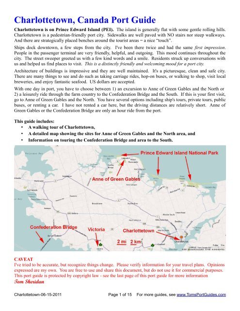
<strong>Charlottetown</strong> is on Prince Edward Island (PEI). The island is generally flat with some gentle rolling hills.<br />
<strong>Charlottetown</strong> is a pedestrian-friendly port city. Sidewalks are well paved with NO stairs nor steep walkways.<br />
And there are strategically placed benches around the tourist areas = a nice “touch”.<br />
Ships dock downtown, a few steps from the city. I've been there twice and had the same first impression.<br />
People in the passenger terminal are very friendly, helpful, and outgoing. This mood continues throughout the<br />
city. The street sweeper greeted us with a few kind words and a smile. Residents struck up conversations with<br />
us and helped us find places to visit. This is a distinctly friendly and welcoming mood for a port city.<br />
Architecture of buildings is impressive and they are well maintained. It's a picturesque, clean and safe city.<br />
There are many things to see and do such as taking carriage rides, hop-on buses, or walking to shop, visit local<br />
breweries, and enjoy fantastic seafood. US dollars are accepted.<br />
With one day in port, you have to choose between 1) an excursion to Anne of Green Gables and the North or<br />
2) a leisurely ride through the farm country to the Confederation Bridge and the South. If this is your first visit,<br />
go to Anne of Green Gables and the North. You have several options including ship's tours, private tours, public<br />
buses, or renting a car. I have not rented a car here, but the driving distances are relatively short. Anne of<br />
Green Gables or the Confederation Bridge are only an hour ride from the port.<br />
This guide includes:<br />
• A walking tour of <strong>Charlottetown</strong>,<br />
• A detailed map showing the sites for Anne of Green Gables and the North area, and<br />
• Information on touring the Confederation Bridge and area to the South.<br />
CAVEAT<br />
I've tried to be accurate, but recognize things change. Please verify information for your travel plans. Opinions<br />
expressed are my own. You are free to use and share this document, but do not use it for commercial purposes.<br />
This port guide is protected by copyright law - see the last page of this port guide for more information<br />
Tom Sheridan<br />
<strong>Charlottetown</strong>-06-15-2011 Page 1 of 15 For more guides, see www.<strong>Toms</strong><strong>Port</strong><strong>Guide</strong>s.com
Table of Contents<br />
The port area 2<br />
<strong>Charlottetown</strong> walking tour 3<br />
Route to Anne of Green Gables & the North 8<br />
Confederation Bridge & the South 12<br />
Goal of port guides - your feedback is important 15<br />
Use this address to find the port in Google maps Water St & Weymouth St, <strong>Charlottetown</strong>, PEI, <strong>Canada</strong>.<br />
Cars, cabs, and public buses are restricted to the parking lot. Ship sponsored tours load and unload passengers<br />
next to the terminal. The red dots in the photo below show the walking route to Prince St to enter the city.<br />
Internet WiFi service is free in the terminal; bring your laptop. Several friendly and helpful people are available<br />
to help you plan your day. Be sure to check which restaurants are open.<br />
There are carriages, harbor hippos, and hop-on buses. I prefer to walk and have created a suggested walking<br />
tour showing some of the areas you may wish to visit. You can't get lost and it's fun to explore on your own.<br />
<strong>Charlottetown</strong>-06-15-2011 Page 2 of 15 For more guides, see www.<strong>Toms</strong><strong>Port</strong><strong>Guide</strong>s.com
Suggested Walking Tour<br />
1 – Passenger terminal exit. Follow the red arrows in this map and walk along the boardwalk to the West.<br />
2 – Prince Street. Walk North to Water Street<br />
3 -Water Prince Corner Shop<br />
This seafood restaurant is a favorite with locals. The<br />
restaurant offers every conceivable type of seafood.<br />
It's superb! We met several people on the ship who ate<br />
there and we all agreed, this is a great little restaurant.<br />
Seating space is limited. The décor is simple, but it's<br />
clean and functional. Service is great and the prices<br />
are reasonable. Whether it's a quick snack or a full<br />
meal, I highly recommend this restaurant.<br />
The website is www.waterprincelobster.ca<br />
Email is fish_waterprince@pei.aibn.com<br />
I believe the owner is Shane Campbell.<br />
TIP – Check with locals re best time to eat here. We<br />
went early to avoid the lunch crowd.<br />
<strong>Charlottetown</strong>-06-15-2011 Page 3 of 15 For more guides, see www.<strong>Toms</strong><strong>Port</strong><strong>Guide</strong>s.com
4 – Trinity Church Prince St & Sydney St 5 – St. Dunstan's Basilica Sydney St & Great George St<br />
Interior of St. Dunstan's Basilica<br />
<strong>Charlottetown</strong>-06-15-2011 Page 4 of 15 For more guides, see www.<strong>Toms</strong><strong>Port</strong><strong>Guide</strong>s.com
6 – Old Dublin Pub, Claddagh Oyster House 7- Gahan House Sims Wine Bar<br />
131 Sydney St 126 Sydney St<br />
The Olde Dublin Pub has live Irish entertainment in the summer. Frommers describes the Claddagh Room as a<br />
good place for seafood. I haven't been there. We had lunch at the Gahan House once. The brewery is on view<br />
in the basement. The beer was good and the food was “OK - typical” bar food.<br />
8 – Ann of Green Gables Store<br />
This is on Queen St. and Richmond St. The sign over<br />
Richmond St. reads “Victoria Row”. Victoria Row is<br />
a narrow, pedestrian extension of Richmond St to the<br />
South. It's generally closed to vehicle traffic.<br />
You can buy books about Anne of Green Gables at<br />
this store. The next building to the right is an Anne of<br />
Green Gables Chocolate Store.<br />
<strong>Charlottetown</strong>-06-15-2011 Page 5 of 15 For more guides, see www.<strong>Toms</strong><strong>Port</strong><strong>Guide</strong>s.com
9 – Shops, restaurants, etc. on Victoria Row (a narrow, pedestrian street extension from Richmond St)<br />
Fish Bones Seafood Grill is on Victoria Row<br />
We usually walk back to the dock via Great George St.<br />
10 -Peake's Quay – a restaurant, bar with souvenir shops in the area On Great George St South of Water St<br />
<strong>Charlottetown</strong>-06-15-2011 Page 6 of 15 For more guides, see www.<strong>Toms</strong><strong>Port</strong><strong>Guide</strong>s.com
Cows is next to Peake's Quay<br />
11 -Lobster on the Wharf Prince St near the ship<br />
<strong>Charlottetown</strong>-06-15-2011 Page 7 of 15 For more guides, see www.<strong>Toms</strong><strong>Port</strong><strong>Guide</strong>s.com
Exploring Prince Edward Island From <strong>Charlottetown</strong><br />
We've been to <strong>Charlottetown</strong> on cruise ships in October and May. We took two excursions to:<br />
• Anne of Green Gables and the area to the North<br />
• Confederation Bridge and the area to the South<br />
Anne of Green Gables and the area to the North<br />
You have several options such as the ship's excursion, a private tour, taking a public bus, or renting a car. We<br />
took a 6-hour private tour. I wanted to control how my time was spent focusing on the coast, fishing villages,<br />
etc. and avoiding stops at souvenir shops. Now that I know where to go and what to see, I would consider<br />
renting a car on my next visit of the area to explore the North. It's only about 60 km and an hour drive one way.<br />
I've included specific addresses to create your own map and use your GPS if you rent a car. CAUTION: this is<br />
a very popular vacation area so you may run into heavy traffic and road construction in the summer months.<br />
Suggested driving route to Anne of Green Gables and the area to the North.<br />
The tour begins at the ship, stops at Prince Edward Island Preserve Company, Anne of Green Gables historic<br />
farmhouse site, Lucy Maud Montgomery's birthplace and continues North with a photo stop at French River.<br />
We went to many other areas in the North including fishing villages and the Prince Edward Island National Park<br />
but I do not have the exact locations where we stopped. I know the ship's tours go to Prince Edward Island<br />
Preserve Company and Anne of Green Gables, but I'm not sure where else they stop. Our private tour also went<br />
to the PEI National Park along the coast which is beautiful.<br />
<strong>Charlottetown</strong>-06-15-2011 Page 8 of 15 For more guides, see www.<strong>Toms</strong><strong>Port</strong><strong>Guide</strong>s.com
Cruise Ship Terminal<br />
To locate the cruise ship on a map or GPS, enter Weymouth St & Water St, <strong>Charlottetown</strong>, PEI, <strong>Canada</strong><br />
Prince Edward Island Preserve Company<br />
Most tours stop here.<br />
It's a clean and<br />
comfortable site to<br />
taste samples, have a<br />
drink, buy preserves<br />
and souvenirs, and use<br />
the toilets. They also<br />
sell tea, Celtic jewelry,<br />
porcelain, etc.<br />
Anne of Green Gables<br />
The address is 2841 New Glasgow Rd, New Glasgow, PE C0A 1N0, <strong>Canada</strong><br />
Anne is a fictional character of a young girl with red<br />
pigtails who grew up on the Green Gables farm. The<br />
writer, Lucy Maud Montgomery, was born and raised on<br />
Prince Edward Island. There are nine books in the series<br />
and they appeal to children-teens. My wife, Mary, thinks<br />
“young” and really likes them.<br />
The “official” name for Anne of Green Gables farm is:<br />
L M Montgomery's Cavendish National Historic Site.<br />
Enter “Route 6 & Route 13, Cavendish, PEI, <strong>Canada</strong>”<br />
to find it on a Google map or a GPS . The entrance is on<br />
Route 6, 750 feet West of Route 13.<br />
2011 Information:<br />
Hours Open 7 days a week 9:00am to 5:00pm,<br />
May 1 through October 31<br />
Directions:<br />
Prince Edward Island National Park is located along<br />
the north shore of the Island. The Park extends 40 km<br />
stretching from Cavendish to Dalvay, with an<br />
additional section to the east at Greenwich.<br />
Green Gables is located on Route 6 in Cavendish.<br />
From <strong>Charlottetown</strong> follow Route 2 west 30 km to<br />
Hunter River. Turn right onto Route 13 in Hunter<br />
River and follow for approximately 20 km to the<br />
intersection of Route 13 and 6 in Cavendish. Turn left<br />
from Route 13 onto route 6. Green Gables is located<br />
on the left, approximately 250 meters from the<br />
intersection.<br />
Admission $ 7.80 (adult) $ 6.55 (Senior)<br />
The historical site website is http://www.pc.gc.ca/eng/lhn-nhs/pe/greengables/visit.aspx<br />
Caution: There are other sites called “Anne of Green Gables” in the area<br />
capitalizing on the “name” and selling souvenirs, buggy rides, etc. The<br />
address I have listed above is the “real deal”.<br />
When you enter the site, you<br />
see a short video introduction.<br />
After that, you are free to<br />
explore on your own. There<br />
are several buildings, a shop<br />
selling drinks and snacks, the<br />
famous “lover's lane”, etc. It's<br />
a picturesque and peaceful<br />
setting with many photo<br />
opportunities. Be sure to put<br />
on the hat with the red pigtails<br />
and take a photo.<br />
Lucy Maud Montgomery<br />
Great photo opportunity- Mary thinks “young”<br />
<strong>Charlottetown</strong>-06-15-2011 Page 9 of 15 For more guides, see www.<strong>Toms</strong><strong>Port</strong><strong>Guide</strong>s.com
Lover's lane The original house<br />
Lucy Maud Montgomery's Birthplace<br />
The author was born a few miles from the historic site<br />
of Anne of Green Gables farmhouse. Continue West on<br />
Route 6 to Route 20. As Route 20 crosses Route 6, the<br />
name of Route 20 changes to Route 8 to the South.<br />
Lucy Maud's house is on Route 20 about 100 feet North<br />
of Route 6. The address to use in Google maps is<br />
New London, PE C0B 1M0, <strong>Canada</strong>.<br />
Lucy Maud Montgomery's Birthplace<br />
<strong>Charlottetown</strong>-06-15-2011 Page 10 of 15 For more guides, see www.<strong>Toms</strong><strong>Port</strong><strong>Guide</strong>s.com
Prince Edward Island (PEI) National Park<br />
The park is accessible from anywhere along the North coast. It's a narrow, wooded sliver of land stretching 40<br />
km along the northern coast fronting the Gulf of St. Lawrence. The park includes superlative red sandstone<br />
cliffs, offshore bars, submerged estuaries, and some of <strong>Canada</strong>'s longest and most popular beaches.<br />
Red sandstone and sand dunes along the coast<br />
PEI and Cavendish are popular vacation areas:<br />
In the summer months, these areas are very crowded due to the variety of vacation opportunities including<br />
biking and hiking trails, beaches, water activities including fishing and catching your own lobster, camping,<br />
amusement parks, golf, etc. The tourist bureau states:<br />
The beaches attract thousands of visitors from around the world... and the beaches are just the<br />
beginning. Swim in crystal blue water warmed by the Gulf stream. There's no shortage of things to do<br />
in the Cavendish area. Golf on world-class championship courses or play mini-golf with the kids. Try<br />
deep sea fishing, horse back riding, para sailing, sea kayaking, riding a roller coaster or visiting sites<br />
that make history come alive. Treat yourself to a quick snack or relax and enjoy a fine dining<br />
experience. You decide what kind of vacation you want.<br />
Busy and active... quiet and relaxing... or a bit of both. In Cavendish and the Dune Shores, we leave<br />
that up to you! Cavendish is surrounded by small farming communities and fishing villages with an<br />
atmosphere all their own. Shop for antiques and unique art crafted by local artisans or explore a<br />
botanical garden, knowing that on PEI you’re never far from the sea.<br />
<strong>Charlottetown</strong>-06-15-2011 Page 11 of 15 For more guides, see www.<strong>Toms</strong><strong>Port</strong><strong>Guide</strong>s.com
French River – Scenic Lookout<br />
There is a scenic view of a small fishing village called Hostetter's Viewscape. The address to use in a map or<br />
GPS is Howatt Rd & Route 20, Prince Edward Island, <strong>Canada</strong>. The scenic lookout is 2250 feet South of<br />
Howatt Rd. on Route 20.<br />
There are many other scenic views in this area along the coast.<br />
CAVEAT – I did not rent a car and drive this route from the ship to French River.<br />
My wife and I took a private tour. Now that I know the exact location of the major sites and I know the total<br />
route is only 60 km and 1 hour driving time, non-stop, I would consider renting a car next time to tour the area<br />
to the North on my own. Be mindful of the fact that renting a car takes a lot of time and might reduce your time<br />
to see the sights by as much as an hour considering travel time to/from the rental. Paperwork, getting gas etc.<br />
Regardless of how you get there, I highly recommend that you visit Anne of Green Gables and the PEI National<br />
Park. You could take a ship excursion or a public bus. These are must see areas.<br />
Confederation Bridge and the area to the South<br />
On our second cruise to <strong>Charlottetown</strong>, we took the ship's bus excursion to Confederation Bridge and the area to<br />
the South. I liked this tour. Personally, I would not consider driving this tour in a rented car.<br />
The reason is the bus took a scenic route which crisscrossed the back roads of Prince Edward Island. This tour<br />
wasn't simply about getting there, the journey was a key part of the tour. We spent most of our time leisurely,<br />
and comfortably, driving through the countryside. The island is very attractive with gentle rolling hills and<br />
farmland. We saw a gazillion churches of many denominations. The tour guide went into great detail to tell us<br />
about the island, the people, the sights, etc. And she was very good. We stopped at the Confederation Bridge<br />
visitors center area. It was all about souvenirs, but the toilets were clean. Then we stopped a short distance<br />
away to photograph the bridge and made a final stop at Victoria to take some photos of the fishing village.<br />
<strong>Charlottetown</strong>-06-15-2011 Page 12 of 15 For more guides, see www.<strong>Toms</strong><strong>Port</strong><strong>Guide</strong>s.com
Confederation Bridge - The bridge is about an hour drive from <strong>Charlottetown</strong>.<br />
The map below shows the Confederation Bridge and a scenic fishing village at Victoria.<br />
The bridge connects Prince<br />
Edward Island and New<br />
Brunswick. This curved,<br />
12.9 km (8 mile) long<br />
bridge is the longest in the<br />
world crossing ice-covered<br />
water, and is one of<br />
<strong>Canada</strong>’s top engineering<br />
achievements of the 20th<br />
century.<br />
The waters can be covered<br />
with ice for 5 months so a<br />
special design was used for<br />
the bridge supports. Each<br />
supporting pier has a “curved collar shape” as it enters the water. This causes the ice to raise up and break,<br />
under it's own weight, thus preventing the ice from damaging the bridge.<br />
Our bus tour stopped at the visitor center and then drove to the area on the map “take photos here”.<br />
CAUTION – if you are driving a rental car, do NOT enter the bridge road. If you do,<br />
you're committed to drive the 8 mile bridge and paying $ 43.<br />
<strong>Charlottetown</strong>-06-15-2011 Page 13 of 15 For more guides, see www.<strong>Toms</strong><strong>Port</strong><strong>Guide</strong>s.com
Note the rust colored “collars” at the base which are designed to cause the ice to raise up and break under it's own<br />
weight as it falls down. This design protects the bridge from ice which covers the sea 5 months of the year.<br />
Victoria<br />
There is a scenic fishing village. Use this address on Google maps<br />
13 Russell St, Victoria, Prince Edward Island, <strong>Canada</strong><br />
<strong>Charlottetown</strong>-06-15-2011 Page 14 of 15 For more guides, see www.<strong>Toms</strong><strong>Port</strong><strong>Guide</strong>s.com
Goal of <strong>Port</strong> <strong>Guide</strong>s - Your Feedback Is Important<br />
Goal<br />
<strong>Port</strong> guides are designed to help you plan a great cruise vacation<br />
by providing information including:<br />
• Where the ship docks,<br />
• Whether you can walk to the nearby town,<br />
• Things to see and do,<br />
• Options for self-guided or organized tours, and<br />
• Travel issues unique to the port area.<br />
With this information in hand, you can plan the cruise for your priorities. Knowledge of<br />
ports is important because you have to make many decisions and commitments long<br />
before your ship arrives in the port.<br />
Why feedback is important<br />
User feedback helps me fine tune the subjects included, the length of guides, format, etc.<br />
And I welcome offers to collaborate with me by providing information for inclusion in<br />
the guides.<br />
The guides serve as an introduction to a port and are not intended to answer every<br />
question about the details of each port and tourist destination. There are other sources of<br />
information such as www.CruiseCritic.com for your detailed questions. Knowledgeable<br />
CC members will share their information.<br />
Schedule<br />
I created my www.<strong>Toms</strong><strong>Port</strong><strong>Guide</strong>s.com website in April 2011 and posted 10 port guides<br />
by June. My goal is to add at least one new guide a month.<br />
I wish you a great cruise vacation.<br />
Regards,<br />
Tom Sheridan<br />
Copyright Notice<br />
My port guides are protected by copyright law. You are free to use them for noncommercial<br />
purposes, to attach them to emails and distribute them as electronic or printed<br />
files, but you cannot sell them. You are free to post the port guide pdf files on web sites.<br />
But it is better to post a link to my web site. This makes it easier for people to see the<br />
new guides and obtain the latest updates. The name of each guide includes the date it was<br />
published or last updated. For example, the guide for Rome is “Rome-04-10-2011.pdf”.<br />
Use this link for my website: www.<strong>Toms</strong><strong>Port</strong><strong>Guide</strong>s.com<br />
You cannot change my port guides and must leave this copyright notice intact. The<br />
guides are exclusively owned by Thomas Sheridan. I can be contacted by email at:<br />
<strong>Toms</strong><strong>Port</strong><strong>Guide</strong>s@comcast.net<br />
<strong>Charlottetown</strong>-06-15-2011 Page 15 of 15 For more guides, see www.<strong>Toms</strong><strong>Port</strong><strong>Guide</strong>s.com