Boston-04-21-2013 - Toms Port Guides
Boston-04-21-2013 - Toms Port Guides
Boston-04-21-2013 - Toms Port Guides

Create successful ePaper yourself
Turn your PDF publications into a flip-book with our unique Google optimized e-Paper software.
<strong>Boston</strong> <strong>Port</strong> Guide<br />
Consider yourself lucky if <strong>Boston</strong> is a port of call for your cruise.<br />
It's an amazing, wonderful, clean city to visit with many things to<br />
see and do, and it's ideally suited for self-guided touring by<br />
walking, trolley tours, and public transit. It's easy to find your<br />
way around. The Freedom Trail is marked with brick and painted<br />
lines showing the route to sixteen historic sites.<br />
<strong>Boston</strong> was the “Cradle of Liberty,” the center of the<br />
Revolutionary War. Popular historic sites include the Old North<br />
Church, Bunker Hill Monument, and the battlefields in Lexington<br />
and Concord.<br />
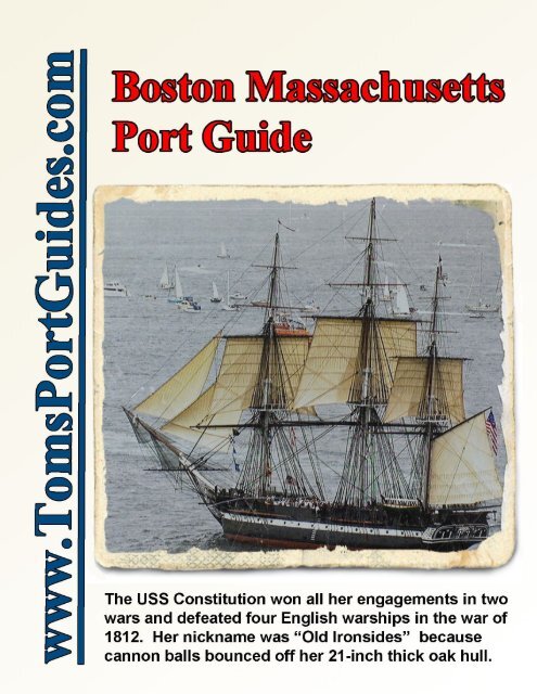
The USS Constitution was built in <strong>Boston</strong>. Her <strong>21</strong>-inch thick oak hull was strong enough to make cannon balls<br />
bounce off. She won ALL her engagements in two wars and surprised the world by defeating four English<br />
warships in the war of 1812. I was excited to walk the decks of such a victorious ship.<br />
For a relaxing, scenic tour to see the city from a different perspective, take a harbor cruise.<br />
If you're interested in sports, visit TD Garden or Fenway Park. And if you want to relax, have some great food,<br />
or do some shopping, Faneuil Hall – Quincy Market is the place to go. It's my favorite.<br />
I've packed this guide with links to websites, maps, descriptions and location of tourist sites, plus travel tips.<br />
This can help you plan your day in port for your priorities. When you've decided which tourist sites to visit, I<br />
suggest you look for the best “promotional package” to save money on trolley tours, harbor tours, and<br />
admission to museums and tourist sites. The promotions are often listed on websites. We shop the promotional<br />
packages at the trolley companies and make our decision when we arrive in <strong>Boston</strong>.<br />
Table of Contents<br />
Subject<br />
Pages<br />
Overview map - cruise ship dock, <strong>Boston</strong> tourist sites, Logan airport 2<br />
Cruise port area map 3<br />
Using GPS coordinates to plan self-guided touring 3<br />
Bus route map from cruise port to Logan airport 4<br />
Using public transport from the cruise port to explore <strong>Boston</strong> 5<br />
Tips on selecting a trolley tour 6<br />
Tourist Sites in the Faneuil Hall and Quincy Market area 7-11<br />
Harbor tours 11-12<br />
Tourist sites in the Paul Revere House to Bunker Hill Monument area 12-15<br />
Tourist sites in the <strong>Boston</strong> Common area 16-18<br />
Copley Square, Fenway Park, & Harvard University 19-20<br />
Self-guided vs. Ship's excursion tours of <strong>Boston</strong> 20<br />
Lexington & Concord 20-<strong>21</strong><br />
Lexington Green 22-25<br />
Meriam's Corner 26<br />
North Bridge 27-29<br />
Goal of port guides – Your feedback is important 30<br />
CAVEAT<br />
Information contained herein is believed to be accurate. PLEASE verify information for your travel plans.<br />
Opinions expressed are my own. You are free to use and share this guide for non-commercial purposes. This<br />
port guide is protected by copyright law - see the last page of this guide for legal notices.<br />
Tom Sheridan<br />
<strong>Boston</strong>-<strong>04</strong>-<strong>21</strong>-<strong>2013</strong> Page 1 of 30 For more guides, see www.<strong>Toms</strong><strong>Port</strong><strong>Guides</strong>.com
Overview Map – Cruise Ship Dock - <strong>Boston</strong> Tourist Sites – Logan Airport<br />
Cruise ships line up along Black Falcon Cruise<strong>Port</strong> (lower right corner of map above)<br />
<strong>Boston</strong> Logan International Airport is 4.2 miles and a 10 minute, ~ $ 25 taxi ride.<br />
South Station (bus & train) is west of the <strong>Boston</strong> Tea Party Ship & Museum. It is a 1.4 mile, 27 minute walk from the Cruise<strong>Port</strong> to South Station.<br />
Faneuil Hall is a 3-mile, 9-minute ride from the Cruise<strong>Port</strong><br />
<strong>Boston</strong>-<strong>04</strong>-<strong>21</strong>-<strong>2013</strong> Page 2 of 30 For more guides, see www.<strong>Toms</strong><strong>Port</strong><strong>Guides</strong>.com
Cruise<strong>Port</strong> Area Map<br />
The map above shows several landmarks near the cruise dock. Printed maps for the city of <strong>Boston</strong> often show<br />
the South Station Bus & Train Terminal. It's a major public transit hub. The <strong>Boston</strong> Design Center is<br />
referenced in public transit directions. Note that it is next to the cruise ship dock. I have included several other<br />
landmarks in the map above.<br />
Using GPS Coordinates to Plan Self-Guided Touring<br />
This port guide references many excellent tourist maps with links to download them.<br />
But no printed map can match the features of Google Maps:<br />
• Magnify the map scale to see fine detail near the GPS coordinates,<br />
• Use aerial and earth views to see buildings and the landscape,<br />
• Drag the little yellow man icon onto the map to see street views, and<br />
• Use “Get Directions” to plan travel route and time by car, bus, walking, or bicycle.<br />
Use this list of GPS coordinates for Cruise<strong>Port</strong> area sites:<br />
Black Falcon Cruise<strong>Port</strong> GPS = N 42 20.634, W 71 01.987<br />
website = http://www.massport.com/port-of-boston/Pages/Default.aspx<br />
<strong>Boston</strong> Logan Airport GPS = N 42 22 10.23, W 71 1 12.32<br />
website = http://www.massport.com/logan-airport/Pages/Default.aspx<br />
<strong>Boston</strong> Convention and Exhibition Center GPS = N 42 20 44.49", W 71 2 45.64<br />
No Name Restaurant GPS = N 42 <strong>21</strong> 0.59, W 71 2 19.33<br />
Seaport World Trade Center GPS = N 42 <strong>21</strong> 0.08, W 71 2 29.88<br />
<strong>Boston</strong> Tea Party Ship & Museum GPS = N 42 <strong>21</strong> 8.29, W 71 3 4.29<br />
website = http://www.bostonteapartyship.com/ Adult admission = $ 25<br />
South Station Bus Terminal GPS = N 42 <strong>21</strong> 0.65, W 71 3 20.71<br />
To illustrate the use of Google “Get Directions” to plot bus routes, I entered GPS coordinates for the Cruise<strong>Port</strong><br />
and Logan Airport. Then I clicked on the “bus” icon to create the map on the next page.<br />
<strong>Boston</strong>-<strong>04</strong>-<strong>21</strong>-<strong>2013</strong> Page 3 of 30 For more guides, see www.<strong>Toms</strong><strong>Port</strong><strong>Guides</strong>.com
Google “Get Directions” Bus Route Map from the Cruise<strong>Port</strong> to <strong>Boston</strong> Airport<br />
The http://www.mbta.com website shows this route is 29 minutes at a cost of $ 2.50 regular fare or $ 1.00 senior fare<br />
Enlarge this map to see more detail.<br />
<strong>Boston</strong>-<strong>04</strong>-<strong>21</strong>-<strong>2013</strong> Page 4 of 30 For more guides, see www.<strong>Toms</strong><strong>Port</strong><strong>Guides</strong>.com
Using Public Transit to Explore <strong>Boston</strong> from the Cruise <strong>Port</strong><br />
<strong>Boston</strong> has an excellent public transit system. It is low cost and goes everywhere. The Silver Line SL2 bus line<br />
circles the cruise terminal (map below).<br />
See http://www.mbta.com/ for public transit maps, schedules, pricing, etc.<br />
The key landmark for the cruise port is “<strong>Boston</strong> Design Center.” I searched the http://www.mbta.com/<br />
website for the route from the <strong>Boston</strong> Design Center to Faneuil Hall. The cost is $ 2.00 regular fare, $ 0.75 for<br />
seniors. Travel time involves walking 7 minutes from the <strong>Boston</strong> Design Center to Summer St & Dry Dock<br />
Ave, riding a bus for 11 minutes, and walking 8 minutes from Franklin St. & Devonshire St. to Faneuil Hall.<br />
Getting from the cruise ship to center city, Faneuil Hall GPS = N 42 <strong>21</strong> 36.52, W 71 3 <strong>21</strong>.58<br />
A Long Walk:<br />
It's a 2-mile, 40-minute walk from the cruise ship dock to center city, Faneuil Hall. That's too far for me.<br />
Public Transit Is Excellent, Goes Everywhere, and Is Cheap:<br />
There are many bus stops near the cruise dock. Enter GPS coordinates for the cruise dock and Faneuil Hall into<br />
“Get Directions” and click on the bus icon. Alternatively, use the http://www.mbta.com/ website with “<strong>Boston</strong><br />
Design Center” as starting point and “Faneuil Hall” as the end point. It's a 15-30 minute trip, depending on time<br />
of day. Regular fare is $ 2; senior fare is $ 0.75. Plan your travel to get back to the ship on time.<br />
Cruise Ship Shuttle:<br />
We took the ship's shuttle from the cruise dock to Faneuil Hall for $ 15/person round-trip. We didn't have to<br />
worry about heavy traffic or crowded buses in the afternoon and the ship would not leave without us.<br />
Old Town Trolley Tours http://www.trolleytours.com/boston/<br />
Old Town Trolley Tours is the only trolley company with a stop at the cruise dock when ships are in port.<br />
Getting the trolley at the port is confusing. Please read this section carefully and check the website listed above.<br />
Some cruise ships sell tickets for Old Town Trolley Tours at the ship's excursion desk. If you buy a ticket<br />
from your ship, the tour is only a 1.5 hour drive through the city with NO stops. I don't know why anyone<br />
would limit their tour of <strong>Boston</strong> to a non-stop, narrated drive through the city. <strong>Boston</strong> is a wonderful city!!<br />
<strong>Boston</strong>-<strong>04</strong>-<strong>21</strong>-<strong>2013</strong> Page 5 of 30 For more guides, see www.<strong>Toms</strong><strong>Port</strong><strong>Guides</strong>.com
If you buy your ticket directly from Old Town Trolley Tours, you have a full day of HopOn, HopOff use<br />
of the trolley with 19 stops in <strong>Boston</strong>. Unfortunately, you cannot buy a ticket directly from Old Town Trolley<br />
Tours at the cruise port. You have to buy the trolley ticket online and won't get a refund if your plans change.<br />
To summarize this confusing situation:<br />
• The only place you can purchase a trolley ticket at the cruise port is at the ship's excursion desk. Your<br />
ship may offer the 1.5 hour, non-stop trolley tour as an excursion. Our ship did not offer this tour.<br />
• If you buy a trolley ticket online, you cannot return the ticket for a refund.<br />
• If you want the flexibility to purchase a full-day, HOHO trolley ticket when your ship arrives in port,<br />
you have to go into <strong>Boston</strong>'s center city to purchase the ticket.<br />
Tips on Selecting a Trolley Tour<br />
Time in port is limited. Throughout this guide, I have listed many popular tourist sites with information on GPS<br />
location and weblinks to help you research tours of museums, ball parks, etc., to plan your day in <strong>Boston</strong>.<br />
Prioritize the tourist sites you wish to visit and select the trolly tour company that best meets your needs.<br />
Trolley companies offer:<br />
• Different “promotional packages,” at great prices, combining the trolley tour with admission to<br />
museums, sports centers, tourist sites, harbor cruises, etc. Find the best package for your interests.<br />
• Trolleys have different routes and number of stops. Download the route maps listed below. You can<br />
purchase a ticket online at a discounted price, but the ticket is non-refundable. I prefer to research the<br />
trolley tours before my cruise and buy the tickets in <strong>Boston</strong>. Check the websites, or call the trolley<br />
company, to determine where you can buy tickets for the trolley tour your want.<br />
Three trolley tour companies are rated 4.5 out of 5.0 by TripAdvisor:<br />
Old Town Trolley Tours<br />
website = http://www.trolleytours.com/boston/<br />
Download the route map from http://www.trolleytours.com/boston/images/boston-mass-map1.pdf<br />
<strong>Boston</strong> Upper Deck Trolley Tours website = http://bostonsupertours.com/<br />
Download the route map from http://bostonsupertours.com/wp-content/uploads/2012/<strong>04</strong>/mapOnly.pdf<br />
CityView Trolley Tours<br />
website = http://www.cityviewtrolleys.com/boston/<br />
Download the route map from http://www.cityviewtrolleys.com/boston/<strong>Boston</strong>_PDF/<strong>Boston</strong>Map.pdf<br />
For our needs, CityView Trolley Tours was the best choice. We bought tickets for $ 35/person near Faneuil Hall<br />
in October 2012. I wanted this tour “package” because it included a free harbor tour, an $ 18 value. Another<br />
issue was the seats on the trolley. “Authentic” trolley seats are wood slat. I find wood slat seats very<br />
uncomfortable. CityView has padding on both the bottom and back of the seats.<br />
Harbor Cruise Tours<br />
I highly recommend a harbor cruise tour. The price is ~ $18, but it was free with our trolley tour. Tour boats<br />
are big with room to walk around. It is a relaxing tour.<br />
Views of the city are unobstructed from the back and upper deck of the boat. If you're a photographer, you'll<br />
love it. I had great views of the city and the USS Constitution. You can't take these photos from the land side<br />
because you can't get back far enough to frame the photo and there is always something in your way.<br />
The harbor tour lasts ~ 40 minutes. It originates at Long Wharf near the Marriott Hotel, across the street from<br />
the Faneuil Hall area. The boat stops next to the USS Constitution allowing passengers to get on/off. Then it<br />
heads toward the <strong>Boston</strong> Fish Pier area before turning around to dock at Long Wharf. This route gives you the<br />
full, panoramic view of the city skyline.<br />
<strong>Boston</strong>-<strong>04</strong>-<strong>21</strong>-<strong>2013</strong> Page 6 of 30 For more guides, see www.<strong>Toms</strong><strong>Port</strong><strong>Guides</strong>.com
Tourist Sites in the Faneuil Hall – Quincy Market Area<br />
Enlarge this map to see more detail<br />
Faneuil Hall – Quincy Market is one of the most important areas to visit in <strong>Boston</strong>. The cruise ship shuttle bus drops you off as indicated.<br />
Caution – your ship might use another drop-off location. Take a photo when you get off the bus so you can find your bus stop later.<br />
You can buy trolley tour tickets as shown in the map above. Harbor Cruises depart from Long Wharf near the Marriott Hotel. New England<br />
Aquarium (sometimes called “<strong>Boston</strong> Aquarium”) is on Central Wharf.<br />
We always stop for lunch at Durgin-Park restaurant. There are a gazillion restaurants and a hundred stores. It's a wonderful, colorful, and festive<br />
area to spend part of, or a full day. The site of the <strong>Boston</strong> Massacre is next to the Old State House. The Old City Hall Grounds and Old South<br />
Meeting House are only a short walk.<br />
<strong>Boston</strong>-<strong>04</strong>-<strong>21</strong>-<strong>2013</strong> Page 7 of 30 For more guides, see www.<strong>Toms</strong><strong>Port</strong><strong>Guides</strong>.com
I have listed GPS coordinates below for the Faneuil Hall – Quincy Market area sites.<br />
Shuttle bus drop off for Faneuil Hall GPS = N 42 <strong>21</strong> 39.54, W 71 3 14.49<br />
I take a photo of the stop area for the shuttle and trolley, so I will not have difficulty finding that location later.<br />
Faneuil Hall & Quincy Market GPS = N 42 <strong>21</strong> 36.52, W 71 3 <strong>21</strong>.58<br />
website = http://www.faneuilhallmarketplace.com/<br />
Faneuil Hall - Quincy Market is a MUST-Visit area. You could spend all day there.<br />
There are shops, restaurants, street theater, and regular events. Quincy Market is in front of Faneuil Hall as shown in the<br />
photo at left below. There is a tourist information center in Faneuil Hall. Photo of Durgin-Park at right below.<br />
<strong>Boston</strong>-<strong>04</strong>-<strong>21</strong>-<strong>2013</strong> Page 8 of 30 For more guides, see www.<strong>Toms</strong><strong>Port</strong><strong>Guides</strong>.com
Faneuil Marketplace Restaurants<br />
Al Mercatino<br />
Ames Plow Tavern<br />
Anthem Kitchen + Bar<br />
Aris Barbeque<br />
Bagelville We get a round.<br />
Bangkok Express<br />
Berry Twist<br />
<strong>Boston</strong> and Maine Fish Co<br />
<strong>Boston</strong> Café<br />
<strong>Boston</strong> Chipyard<br />
<strong>Boston</strong> Chowda Head ovah heaya.<br />
<strong>Boston</strong> Kitchen<br />
<strong>Boston</strong> Pretzel<br />
<strong>Boston</strong> Pretzel & Lemonade<br />
Carol Ann’s Bake Shop<br />
Cheers<br />
Dick's Last Resort<br />
The Dog House<br />
Durgin Park Restaurant, Oyster Bar<br />
El Paso Enchiladas<br />
Fisherman’s Net<br />
Gourmet India<br />
The Green Organic Bowl<br />
Jen Lai Rice & Noodle Co.<br />
Joey’s Gelateria<br />
Kilvert and Forbes<br />
La Pastaria<br />
McCormick & Schmick’s<br />
Megumi<br />
Mija Cantina & Tequila Bar<br />
MMMac N’ Cheese<br />
The Monkey Bar<br />
Ned Devine's Irish Pub<br />
New York Deli<br />
North End Bakery<br />
Parris<br />
Philadelphia Steak & Hoagie<br />
Piccolo Panini<br />
Pizzeria Regina<br />
The Prime Shoppe<br />
Quincy’s Place Food, Ice Cream & Candy<br />
Salty Dog Seafood Grill & Bar<br />
Sprinkles Ice Cream<br />
Starbucks<br />
Steve’s Greek Cuisine<br />
Ueno Sushi<br />
Wagamama<br />
Walrus and the Carpenter<br />
West End Strollers<br />
Wicked Good Cupcakes<br />
Zuma’s Tex Mex Cafe<br />
Faneuil Marketplace Stores<br />
A Hat For Every Head<br />
Ann Taylor<br />
Arts<strong>Boston</strong>'s BosTix Booth<br />
Belt Stop<br />
Best Gift Idea Ever<br />
Best of <strong>Boston</strong><br />
<strong>Boston</strong> Campus Gear<br />
<strong>Boston</strong> Harley Davidson<br />
<strong>Boston</strong> Logos<br />
<strong>Boston</strong> Pewter Company<br />
<strong>Boston</strong> Pretzel & Lemonade<br />
<strong>Boston</strong> Tote<br />
Boxers To Go<br />
Build-A-Bear Workshop®<br />
Camera Center<br />
Cheers<br />
Cheers Gift Shop<br />
Christmas in <strong>Boston</strong><br />
City View Trolley Tours<br />
Coach<br />
Crabtree & Evelyn<br />
Declaration<br />
Destination <strong>Boston</strong><br />
Every Bead of My Heart<br />
Funusual<br />
Gateway News<br />
Geoclassics<br />
Godiva Chocolatier<br />
Irish Eyes<br />
Just Zip It <strong>Boston</strong><br />
L’Attitude <strong>Boston</strong> Boutique<br />
Life Is a Highway<br />
Lil Peeps<br />
Local Charm<br />
Lucky Décor<br />
Lucy’s League<br />
Magnetic Chef<br />
Merry Trading Company<br />
Michal Negrin<br />
Musically Yours<br />
Newbury Comics<br />
Nine West<br />
Old Town Trolley Tours of <strong>Boston</strong><br />
Orient Express<br />
Origins<br />
Pajama Party<br />
Retail & Office Leasing<br />
Revolutionary<strong>Boston</strong>® Museum Store<br />
Revolutionary<strong>Boston</strong>® Visitor Info Center<br />
Samsonite<br />
Sea <strong>Boston</strong> USA<br />
Silver Star<br />
Sock It To Me <strong>Boston</strong><br />
The Stone Flower<br />
Stuck on Stick Pins<br />
Sunglass Hut & Watch Station<br />
Super Duck Tours<br />
Teeny Billboards<br />
Urban Outfitters<br />
Victoria's Secret<br />
Wicked Good Cupcakes<br />
Yankee Candle Company<br />
<strong>Boston</strong>-<strong>04</strong>-<strong>21</strong>-<strong>2013</strong> Page 9 of 30 For more guides, see www.<strong>Toms</strong><strong>Port</strong><strong>Guides</strong>.com
Durgin Park Restaurant GPS = N 42 <strong>21</strong> 38.00, W 71 3 18.57<br />
We always stop for lunch at Durgin Park website = http://www.arkrestaurants.com/durgin_park.html<br />
It's been in business for 180 years featuring “Yankee Fare”. The beef and chowder are great.<br />
LUNCH SPECIALS<br />
Poor Man's Roast Beef $10.95<br />
Homemade Fish Cakes $8.95<br />
Chicken Livers in wine with bacon $8.95<br />
Chicken Pot Pie $8.95<br />
Shepherd's Pie $10.95<br />
Frankfurters steamed or grilled $7.95<br />
Knockwurst steamed or grilled $7.95<br />
Potted Beef with Onions $7.95<br />
<strong>Boston</strong> Schrod broiled or baked $16.95<br />
Yankee Pot Roast $11.95<br />
Fish and Chips $16.95<br />
SANDWICHES<br />
Fresh Fish Sandwich broiled or fried $10.95<br />
Corned Beef Sandwich $10.95<br />
French Dip $13.95<br />
Hand Carved Turkey Sandwich $9.95<br />
Thanksgiving on a Roll $10.95 stuffing<br />
Fresh Fried Clam Roll $19.95<br />
Grilled Chicken Sandwich $9.95<br />
Crabcake Sandwich $13.95<br />
APPETIZERS<br />
Scallops wrapped in Bacon $9.95<br />
Shrimp Cocktail $12.95<br />
Shrimp Scampi $12.95<br />
Fried Calamari $10.95<br />
Chicken Fingers $7.95<br />
Fresh Jumbo Lump Crab Cake $13.95<br />
Chilled Seafood Platter $29.95<br />
Onion Rings $5.25<br />
Twice Cooked Potato Skins $7.95<br />
Chicken Wings $7.95<br />
OYSTERS & CLAMS Steamed or Raw<br />
Steamers (sometimes sandy) $MP<br />
Cherry Stone (1/2 dozen) $11.95<br />
Cherry Stone Platter (baker's dozen) $<strong>21</strong>.95<br />
Oysters (1/2 dozen) $11.95<br />
Oyster Platter (baker's dozen) $<strong>21</strong>.95<br />
Littleneck (1/2 dozen) $11.95<br />
Littleneck Platter $<strong>21</strong>.95<br />
Mussels (spicy tomato sauce or garlic &<br />
butter) $12.95<br />
Oyster Stew $15.95<br />
SOUPS & CHOWDERS<br />
Fish Chowder Cup $5.25 Bowl $7.25<br />
Clam Chowder Cup $5.25 Bowl $7.25<br />
SALADS<br />
Garden Salad $5.75<br />
Shrimp Salad $14.95<br />
Hearts of Baby Iceberg<br />
smoked bacon, grape tomatoes, bleu<br />
cheese $7.25<br />
Fresh Lobster Salad $MP<br />
Caesar Salad $9.95<br />
Greek Salad $9.95<br />
with a choice of the following<br />
Grilled Chicken $13.95<br />
Grilled Salmon $14.95<br />
Grilled Shrimp $16.95<br />
Sliced Steak $18.95<br />
Old State House & <strong>Boston</strong> Massacre site<br />
GPS = N 42 <strong>21</strong> 31.57, W 71 3 26.48<br />
(photo right)<br />
The Old State House is the oldest surviving public<br />
building in <strong>Boston</strong>. It was built in 1713 to house the<br />
government offices of the Massachusetts Bay Colony.<br />
It stands on the site of <strong>Boston</strong>'s first Town House of<br />
1657-8, which burned in 1711. The Old State House<br />
was a natural meeting place for the exchange of<br />
economic and local news. A Merchant's Exchange<br />
occupied the first floor, and the basement was rented<br />
by John Hancock and others for warehouse space. As<br />
the center of political life and thought in the colonies,<br />
the Old State House has been called one of the most<br />
important public buildings in Colonial America.<br />
website = http://www.bostonhistory.org/s=osh&p=visit<br />
Adult admission = $ 7.<br />
Old South Meeting House GPS = N 42 <strong>21</strong> 25.34, W 71 3 30.74<br />
website = http://www.oldsouthmeetinghouse.org/default.aspx Adult admission = $ 22.<br />
From the meeting of more than 5,000 colonists on December 16, 1773, which started the <strong>Boston</strong> Tea Party, to<br />
the present, the Old South Meeting House has been an important gathering place for nearly three centuries.<br />
Renowned for the protest meetings held here before the American Revolution, this National Historic Landmark<br />
has long served as a platform for the free expression of ideas. Today, the Old South Meeting House is open<br />
daily as a museum and continues to provide a place for people to meet, discuss and act on important issues of<br />
the day. The stories of the men and women who are part of Old South’s vital heritage reveal why the Old South<br />
Meeting House occupies an enduring place in the history of the United States.<br />
<strong>Boston</strong>-<strong>04</strong>-<strong>21</strong>-<strong>2013</strong> Page 10 of 30 For more guides, see www.<strong>Toms</strong><strong>Port</strong><strong>Guides</strong>.com
Old City Hall grounds GPS = N 42 <strong>21</strong> 27.82, W 71 3 34.57<br />
It's a beautiful historic building transformed into offices and a restaurant. There are statues of Benjamin<br />
Franklin and Joshiah Quincy in the courtyard. This location is also the “First Public School Site”.<br />
For the history of the site, see http://www.oldcityhall.com/history.html<br />
Stops for trolleys, the aquarium, and harbor tours are across the street from Faneuil Hall<br />
Old Town Trolley Tours GPS = N 42 <strong>21</strong> 35.81, W 71 3 6.22 (buy tickets at this location)<br />
Cityview Trolley Tours GPS = N 42 <strong>21</strong> 34.72, W 71 3 6.37 (buy tickets at this location)<br />
New England Aquarium GPS = N 42 <strong>21</strong> 32.87, W 71 2 58.79<br />
website = http://www.neaq.org/index.php Adult admission = $ 22.95.<br />
Boats for Harbor Tour GPS = N 42 <strong>21</strong> 35.45, W 71 2 59.29<br />
Our Cityview Trolley tour included a free harbor tour. The harbor tour is about 40 minutes on a big boat with<br />
open aft and upper decks for unrestricted photos. The boat docked for a few minutes at the naval yard. The<br />
harbor tour gives you a different perspective for photos – Bunker Hill and “Old Ironsides” (photo below).<br />
She was nicknamed “Old Ironsides” because cannon balls bounced off her <strong>21</strong>-inch thick oak hull.<br />
<strong>Boston</strong>-<strong>04</strong>-<strong>21</strong>-<strong>2013</strong> Page 11 of 30 For more guides, see www.<strong>Toms</strong><strong>Port</strong><strong>Guides</strong>.com
The harbor tour allows you to see the area from different angles. I<br />
photographed the USS Constitution from three sides and selected the<br />
photo I liked best based on location of the Bunker Hill Monument in the<br />
background. A 10x zoom is more than adequate.<br />
You'll have great views of the Old North Church steeple above the<br />
buildings, the Leonard P. Zakim bridge, and the <strong>Boston</strong> skyline. The<br />
boat moves slowly so you have a lot of time to frame your pictures.<br />
Leonard P. Zakim bridge (photo left)<br />
<strong>Boston</strong> skyline (photo below)<br />
The Paul Revere House to Bunker Hill Monument Area<br />
Use this list of GPS coordinates for the tourist sites in this area:<br />
Paul Revere House GPS = N 42 <strong>21</strong> 49.42, W 71 3 12.84<br />
website = http://www.paulreverehouse.org/about/<br />
On the night of April 18, 1775, silversmith Paul Revere left his small wooden home in <strong>Boston</strong>'s North End and<br />
set out on a journey that would make him into a legend. Today that home is still standing at 19 North Square<br />
and has become a national historic landmark. It is downtown <strong>Boston</strong>'s oldest building and one of the few<br />
remaining from an early era in the history of colonial America.<br />
The Freedom Trail Adult Ticket is $ 13. It includes admission to the Old South Meeting House, the Paul Revere<br />
House, and the Old State House.<br />
TD Garden The Goal GPS = N 42 <strong>21</strong> 54.60, W 71 3 43.93<br />
website = http://www.tdgarden.com/<br />
The arena hosts NHL's <strong>Boston</strong> Bruins, NBA's <strong>Boston</strong> Celtics, and world-renowned concerts, sporting events,<br />
family shows, wrestling, ice shows and so much more. It's home to approximately 200 public events annually. It<br />
is located near North Station, a major public transit station.<br />
<strong>Boston</strong>-<strong>04</strong>-<strong>21</strong>-<strong>2013</strong> Page 12 of 30 For more guides, see www.<strong>Toms</strong><strong>Port</strong><strong>Guides</strong>.com
“The Goal” statue (photo at right) honors Bobby Orr's gamewinning<br />
goal in 1970. In overtime, “the Goal” clinched the<br />
Stanley Cup win over the St. Louis Blues. The Bruins<br />
organization placed a bronze statue outside TD Garden to forever<br />
commemorate the iconic event in <strong>Boston</strong>'s sports history by Hall<br />
of Fame defenseman Bobby Orr.<br />
Paul Revere Statue & Mall GPS = N 42 <strong>21</strong> 55.58, W 71 3 10.81<br />
Old North Church GPS = N 42 <strong>21</strong> 59.37, W 71 3 16.78<br />
Copp's Hill Burying Ground GPS = N 42 22 1.12, W 71 3 22.15<br />
Leonard P. Zakim Bridge GPS = N 42 22 6.69, W 71 3 46.23<br />
USS Constitution GPS = N 42 22 <strong>21</strong>.76, W 71 3 28.78<br />
Bunker Hill Monument Park GPS = N 42 22 34.91, W 71 3 38.53<br />
Tourist Sites in the Paul Revere House to Bunker Hill Monument Area<br />
For reference, I've shown the location of the Harbor Cruises and Cruise Ship Shuttle Bus Stop on this map.<br />
<strong>Boston</strong>-<strong>04</strong>-<strong>21</strong>-<strong>2013</strong> Page 13 of 30 For more guides, see www.<strong>Toms</strong><strong>Port</strong><strong>Guides</strong>.com
Paul Revere Statue & Mall GPS = N 42 <strong>21</strong> 55.58, W 71 3 10.81<br />
website = http://www.paul-revere-heritage.com/landmarks-monument.html<br />
This is the most photographed statue in <strong>Boston</strong>. (Photo<br />
Right) It's next to the Old North Church.<br />
Old North Church GPS = N 42 <strong>21</strong> 59.37, W 71 3 16.78<br />
website = http://oldnorth.com/site/<br />
“One if by land, two if by sea” was to signal the route of<br />
British troops toward Concord. It was a backup signal to<br />
Patriots across the river in Charlestown, in the event Paul<br />
Revere was unable to reach Charlestown to begin his ride.<br />
The Old North Church is not a publicly funded landmark; we suggest a voluntary donation of at least $1 per<br />
person for dropping in. Visitors are seated in box pews to hear a brief 7–10 minute presentation by our staff<br />
<strong>Guides</strong>. (Photo above left). Note: the sign in the church suggests a minimum donation of $ 3/person.<br />
Behind the Scenes 30 minute guided tour ($ 5 adult price) includes:<br />
• The Bell Ringing Chamber: Climb the stairs of the Old North steeple to the room where the teen-aged<br />
Paul Revere worked as a bell ringer. Explore the history and architecture of the steeple, which has been<br />
toppled twice by hurricanes in its 270 year-old history. Listen and learn about the workings of the<br />
oldest set of change bells in North America.<br />
• The Crypt: Walk amongst the 37 tombs constructed below the floors of the Old North between 1732 and<br />
1860. Learn about the construction of the tombs, view artifacts found in the crypt, and hear the history<br />
of those buried there including the Church’s first rector and soldiers killed during the Battle of Bunker<br />
Hill and Breed’s Hill.<br />
Copps Hill Burying Ground GPS = N 42 22 1.12, W 71 3 22.15<br />
website = http://www.celebrateboston.com/sites/copps-hill-burying-ground.htm<br />
website = http://www.hmdb.org/Marker.aspMarker=18898<br />
Copp's Hill Burying Ground was founded in 1659 as Windmill Hill. It was later renamed after William Copp<br />
who owned the land. Thousands of artisans, craftspeople, and merchants are buried on the Hill. Additionally,<br />
thousands of African Americans who lived in the "New Guinea" community at the base of Copp's Hill are<br />
buried in unmarked graves on the Snowhill Street side.<br />
<strong>Boston</strong>-<strong>04</strong>-<strong>21</strong>-<strong>2013</strong> Page 14 of 30 For more guides, see www.<strong>Toms</strong><strong>Port</strong><strong>Guides</strong>.com
USS Constitution GPS = N 42 22 <strong>21</strong>.76, W 71 3 28.78<br />
website = http://www.ussconstitutionmuseum.org/<br />
For background on the nickname “Old Ironsides”, see http://www.eyewitnesstohistory.com/oldironsides.htm<br />
Entrance to the ship is free. It's a fairly steep ramp up to the deck. The ladders below deck are VERY steep.<br />
Bunker Hill Monument Park GPS = N 42 22 34.91, W 71 3 38.53<br />
website = http://www.nps.gov/bost/historyculture/bhm.htm<br />
"Don't fire until you see the whites of their eyes!" This legendary order has come to symbolize the conviction<br />
and determination of the ill-equipped American colonists facing powerful British forces during the famous<br />
battle fought on this site on June 17, 1775. The battle is popularly known as "The Battle of Bunker Hill"<br />
although most of the fighting actually took place on Breed's Hill, the site of the existing monument and exhibit<br />
lodge. Today, a 2<strong>21</strong>-foot granite obelisk marks the site of the first major battle of the American Revolution.<br />
Please Note:<br />
From April 8 through June 30 of <strong>2013</strong>, due to high visitation and safe occupancy requirements, all visitors who<br />
wish to climb the Bunker Hill Monument must first obtain a free climbing pass from the Bunker Hill Museum<br />
at 43 Monument Square. Climbing passes are limited and issued on a first come, first served basis. For more<br />
information, please call 617-242-7275.<br />
<strong>Boston</strong>-<strong>04</strong>-<strong>21</strong>-<strong>2013</strong> Page 15 of 30 For more guides, see www.<strong>Toms</strong><strong>Port</strong><strong>Guides</strong>.com
<strong>Boston</strong> Common – Starting Point for Freedom Trail<br />
South Station Bus Terminal GPS = N 42 <strong>21</strong> 0.65, W 71 3 20.71 is shown on the map for reference. It is 1.4 miles northwest of the cruise ship dock.<br />
Faneuil Hall GPS = N 42 <strong>21</strong> 36.52, W 71 3 <strong>21</strong>.58 is also shown for reference<br />
Cheers GPS = N 42 <strong>21</strong> 20.48, W 71 4 16.17<br />
This is the bar used in the famous TV show.<br />
<strong>Boston</strong>-<strong>04</strong>-<strong>21</strong>-<strong>2013</strong> Page 16 of 30 For more guides, see www.<strong>Toms</strong><strong>Port</strong><strong>Guides</strong>.com
<strong>Boston</strong> Common<br />
<strong>Boston</strong> Common is ~ 50 acres. It's the oldest park in the country, and it has an interesting history. Many years<br />
ago, cattle grazed in the area. Public hangings were held here. The British troops camped here before marching<br />
to Lexington and Concord.<br />
Today, <strong>Boston</strong> Common is a beautiful park and the starting point for the Freedom Trail.<br />
There are sixteen historic sites on the Freedom Trail.<br />
A red brick, or painted line, connects the sites on the Trail. Take a self-guided tour or join a tour at the <strong>Boston</strong><br />
Common Visitors Center at 148 Tremont Street or the Bostix Booth located at Faneuil Hall. If you prefer to<br />
ride, take a trolley, an unofficial guided tour. You'll need to disembark the trolley to see many of the historic<br />
sites. To find out more about guided tours, contact the Greater <strong>Boston</strong> Convention and Visitors Bureau.<br />
See http://www.cityofboston.gov/freedomtrail/<br />
1. <strong>Boston</strong> Common Visitor Center GPS = N 42 <strong>21</strong> 19.20, W 71 3 48.96<br />
2. Massachusetts State House GPS = N 42 <strong>21</strong> 28.99, W 71 3 49.19<br />
3. Park Street Church GPS = N 42 <strong>21</strong> 23.25, W 71 3 43.76<br />
4. Granary Burying Ground GPS = N 42 <strong>21</strong> 26.10, W 71 3 40.87<br />
Granary Burying Ground is next to Park Street Church<br />
5. King's Chapel and Burying Ground GPS = N 42 <strong>21</strong> 28.75, W 71 3 36.02<br />
6. First Public School Site and Ben Franklin Statue GPS = N 42 <strong>21</strong> 28.<strong>21</strong>, W 71 3 35.00<br />
NOTE: This is the same location as the “Old City Hall grounds”<br />
7. Former Site of the Old Corner Bookstore GPS = N 42 <strong>21</strong> 26.62, W 71 3 29.69<br />
NOTE: This site is currently a jewelry store; there is nothing to see or photograph<br />
8. Old South Meeting House GPS = N 42 <strong>21</strong> 25.34, W 71 3 30.74<br />
9. Old State House GPS = N 42 <strong>21</strong> 31.57, W 71 3 26.48<br />
10. <strong>Boston</strong> Massacre Site GPS = N 42 <strong>21</strong> 31.70, W 71 3 26.<strong>04</strong><br />
NOTE: The “<strong>Boston</strong> Massacre Site” is a bronze plaque in the sidewalk next to the “Old State House”<br />
11. Faneuil Hall GPS = N 42 <strong>21</strong> 36.52, W 71 3 <strong>21</strong>.58<br />
12. Paul Revere House GPS = N 42 <strong>21</strong> 49.42, W 71 3 12.84<br />
13. Old North Church GPS = N 42 <strong>21</strong> 59.37, W 71 3 16.78<br />
14. Copp's Hill Burying Ground GPS = N 42 22 1.12, W 71 3 22.15<br />
15. USS Constitution and Charlestown Navy Yard GPS = N 42 22 <strong>21</strong>.76, W 71 3 28.78<br />
16. Bunker Hill Monument GPS = N 42 22 34.91, W 71 3 38.53<br />
If possible, stop at the Visitor Center at <strong>Boston</strong> Common or Faneuil Hall to get the latest, timely advice on the<br />
Freedom Trail and to purchase admission tickets to the sites.<br />
Massachusetts State House GPS = N 42 <strong>21</strong> 28.99, W 71 3 49.19<br />
website = http://www.malegislature.gov/Engage/StateHouseTours<br />
The Massachusetts State House, designed by Charles Bulfinch, the leading architect of his time, is a grand<br />
repository of history as well as an architectural treasure. With a cornerstone laid by Samuel Adams in 1795,<br />
and a dome coppered by Paul Revere in 1802, its marble-floored corridors and spacious ceremonial rooms are<br />
filled with works of art depicting our state’s unique heritage. We welcome you to visit the State House online or<br />
in person. Tours last 45 minutes and are free.<br />
Park Street Church is at the northeast corner of <strong>Boston</strong> Common GPS = N 42 <strong>21</strong> 23.25, W 71 3 43.76<br />
website = http://www.parkstreet.org/<br />
With a steeple over 200 feet high, Park Street Church is a distinctive landmark dating back to the early 1800s.<br />
It's next to the Granary Burying Ground.<br />
Granary Burying Ground GPS = N 42 <strong>21</strong> 26.10, W 71 3 40.87<br />
Each grave contains at least 20 bodies. Three signers of the Declaration of Independence are buried here;<br />
namely, Samuel Adams, John Hancock, and Robert Treat Paine.<br />
<strong>Boston</strong>-<strong>04</strong>-<strong>21</strong>-<strong>2013</strong> Page 17 of 30 For more guides, see www.<strong>Toms</strong><strong>Port</strong><strong>Guides</strong>.com
King's Chapel and Burying Ground GPS = N 42 <strong>21</strong> 28.75, W 71 3 36.02<br />
website = http://www.celebrateboston.com/sites/kings-chapel.htm<br />
King's Chapel was the first Episcopal Church in New England. It is a quaint and interesting place. The interior,<br />
with its high old-fashioned pews, its tall pulpit and sounding board, its massive pillars, and stained-glass<br />
windows, is remarkably historic. The burial ground is the oldest in the city.<br />
Below is a section of the Freedom Trail Map. Enlarge this map 200% to see more detail. Download the<br />
full map from this link http://www.thefreedomtrail.org/maps/pdfs/boston-nps-map.pdf<br />
<strong>Boston</strong>-<strong>04</strong>-<strong>21</strong>-<strong>2013</strong> Page 18 of 30 For more guides, see www.<strong>Toms</strong><strong>Port</strong><strong>Guides</strong>.com
Copley Square, Fenway Park, & Harvard University<br />
It is 4 miles from Copley Square to Harvard University.<br />
Copley Square, Trinity Church GPS = N 42 20 58.91, W 71 4 33.74<br />
See these websites for gorgeous photos of Copley Square<br />
http://friendsofcopleysquare.org/tour.htm<br />
http://www.aviewoncities.com/boston/copleysquare.htm<br />
http://www.greatbuildings.com/buildings/Trinity_Church.html<br />
Copley Square is an architectural delight with an impressive mix<br />
of historic and new buildings.<br />
• Trinity Church was constructed in 1877. It features a red<br />
clay roof, arches, and a tall tower.<br />
• <strong>Boston</strong> Public Library has an Italian-style facade. It was<br />
opened in 1895.<br />
• There are three John Hancock buildings; namely, the old<br />
Hancock building 26-stories, a 60-story glass skyscraper,<br />
and the Stephen L. Brown building.<br />
Photo of Trinity Church (at right)<br />
<strong>Boston</strong>-<strong>04</strong>-<strong>21</strong>-<strong>2013</strong> Page 19 of 30 For more guides, see www.<strong>Toms</strong><strong>Port</strong><strong>Guides</strong>.com
Fenway Park GPS = N 42 20 47.97, W 71 5 49.95<br />
Fenway Park Tours<br />
see http://boston.redsox.mlb.com/bos/ballpark/tour.jsp<br />
If you're a baseball fan, you might want to visit Fenway Park.<br />
Harvard University GPS = N 42 22 25.56, W 71 7 7.86<br />
Harvard is across the Charles River in Cambridge. Some of the cruise ship excursions stop here for a 40-minute<br />
walk through the area with the guide. We weren't interested in walking through the campus. We stopped for a<br />
beer and some finger food at John Harvard's Brew House. It's a great place to visit.<br />
John Harvard's Brew House GPS = N 42 22 20.96, W 71 7 9.34<br />
see https://www.johnharvards.com/locations/cambridge-ma<br />
Self-Guided vs Ship's Excursion Tours of <strong>Boston</strong><br />
My goal is to describe tourist sites and travel options to help you plan your shore excursion for your priorities. I<br />
am not trying to convince you what to do. I'm just describing what we did.<br />
<strong>Boston</strong> is ideal for self-guided touring:<br />
• <strong>Boston</strong> is an amazing, beautiful, clean city with many things to see and do.<br />
• The city government, non-profit organizations, and businesses have worked together to create and<br />
disseminate excellent maps and descriptions of tourist sites via visitor centers and websites. They have<br />
also marked walking pathways and provided guided trolley and harbor tours to help the visitor find his<br />
way around. In addition, the public transit system is excellent, goes everywhere, and is inexpensive.<br />
• I use Faneuil Hall as my base for exploring the city. I visit the information center and check<br />
promotional packages from the trolley companies to decide whether I will use trolleys, harbor cruises,<br />
public transit, walking, etc. to visit tourist sites of interest. There are very few hills in <strong>Boston</strong>; it is easy<br />
to walk.<br />
• I don't need the ship's excursion tour or a guide in <strong>Boston</strong>. Trolley and harbor tours have guides to<br />
explain the sites. And many sites have free guides or a guided tour is included in the admission.<br />
I recommend a guided-tour for Lexington and Concord.<br />
Unless you know history in detail, you'll need a guide. You are traveling a long distance from the ship and need<br />
someone to point out the historic sites. When you walk the battlefields, you'll want a guide to explain what<br />
happened and stop at key landmarks to tell the story.<br />
We've taken two ship's excursion tours to Lexington and Concord. They were very good, but the guide on one<br />
tour was much better than on the other.<br />
The ship's tour began with a drive through <strong>Boston</strong> with stops at Copley Square, Faneuil Hall, TD Garden, and<br />
the Old North Church. On the way back to the ship, we stopped at Harvard University for a walking tour.<br />
See this link for an introduction to American Revolution. In a few minutes, it will orient you to the<br />
location of battles http://www.revolutionarywaranimated.com/LexingtonAnimation.html<br />
<strong>Boston</strong>-<strong>04</strong>-<strong>21</strong>-<strong>2013</strong> Page 20 of 30 For more guides, see www.<strong>Toms</strong><strong>Port</strong><strong>Guides</strong>.com
Map of First Battles of American Revolution<br />
The ship's excursion has a guide to narrate the entire tour. The bus slows down, and the guide points out buildings and landmarks along the route.<br />
The bus parks at Lexington Green so you can walk with the guide to hear the story. Lexington is a very attractive area with well-maintained, historic<br />
buildings. The Visitor Center has a diorama of the battlefield. There are also clean toilets.<br />
The bus drives slowly from Lexington to Meriam's Corner as the guide points out where the troops were. Then the bus parks in Concord so you can<br />
walk with the guide along the Old North Bridge area. There are toilets next to the parking lot.<br />
On the way back to the city, the guide points out Walden Pond, a 100-foot deep, 61-acre lake, formed by glaciers in Concord. It is the setting for the<br />
satirical book, “Walden- Life in the Woods” by Henry David Thoreau published in 1854. Walden Pond GPS = N 42 26 24.69, W 71 20 4.62<br />
The website for Lexington is http://www.libertyride.us/historic.html<br />
Lexington Green<br />
Minuteman Statue GPS = N 42 26 56.08, W 71 13 48.39<br />
Revolutionary Monument GPS = N 42 26 58.33, W 71 13 52.52<br />
BuckmanTavern GPS = N 42 26 57.20, W 71 13 46.84<br />
Visitor Center GPS = N 42 26 56.66, W 71 13 44.22<br />
<strong>Boston</strong>-<strong>04</strong>-<strong>21</strong>-<strong>2013</strong> Page <strong>21</strong> of 30 For more guides, see www.<strong>Toms</strong><strong>Port</strong><strong>Guides</strong>.com
Lexington Green<br />
The map above shows the Visitor Center, two monuments, the minuteman statue and the Buckman Tavern, a<br />
meeting place for the Militia.<br />
This is a very attractive historic area to visit. Please be careful when crossing the street; there's a lot of traffic.<br />
Captain Parker's message to the Militia<br />
<strong>Boston</strong>-<strong>04</strong>-<strong>21</strong>-<strong>2013</strong> Page 22 of 30 For more guides, see www.<strong>Toms</strong><strong>Port</strong><strong>Guides</strong>.com
Lexington Green<br />
Minuteman Statue<br />
<strong>Boston</strong>-<strong>04</strong>-<strong>21</strong>-<strong>2013</strong> Page 23 of 30 For more guides, see www.<strong>Toms</strong><strong>Port</strong><strong>Guides</strong>.com
Revolutionary Monument<br />
Monument<br />
<strong>Boston</strong>-<strong>04</strong>-<strong>21</strong>-<strong>2013</strong> Page 24 of 30 For more guides, see www.<strong>Toms</strong><strong>Port</strong><strong>Guides</strong>.com
Lexington Visitor Center<br />
Be sure to visit the Visitor Center to view the displays (photo below)<br />
There are several tours of the Lexington-Concord area. Some of them originate or stop at the Visitor Center.<br />
We wanted the convenience of stepping onto a tour bus next our ship. We enjoyed the ship's excursion tour.<br />
We took the same ship's tour in May and October (different years) so we had the advantage of seeing trees in<br />
bloom in the spring and the fall color of the leaves. This is a beautiful area any time of the year. The homes are<br />
well-maintained and the scenery is attractive.<br />
<strong>Boston</strong>-<strong>04</strong>-<strong>21</strong>-<strong>2013</strong> Page 25 of 30 For more guides, see www.<strong>Toms</strong><strong>Port</strong><strong>Guides</strong>.com
Download this map from http://www.nps.gov/mima/planyourvisit/brochures.htm<br />
This is a high resolution map. Enlarge it to see more detail.<br />
It is 7.2 miles from Lexington Green to the North Bridge. As the tour bus drove along Minute Man National<br />
Historical Park, the guide told the story of the battles. There is not much to see from the bus.<br />
Meriam's Corner John Meriam House GPS = N 42 27 36.14, W 71 19 25.76<br />
Meriam House (Bing.com birdseye photo at right) is where Colonial militia began a running skirmish, which<br />
continued to <strong>Boston</strong>. The British encountered heavy, unrelenting fire from hundreds of militiamen. British<br />
soldiers fell at every hill or curve where the Americans had position. After the column had passed one spot, the<br />
militiamen would cut across country and be ready for them farther up the road. Yeah for our side.<br />
See the Minuteman National Park website = http://www.nps.gov/mima/planyourvisit/index.htm<br />
Location of tourist sites<br />
Old North Bridge Parking Lot GPS = N 42 28 10.26, W 71 20 55.14<br />
Old North Bridge GPS = N 42 28 8.67, W 71 <strong>21</strong> 1.62<br />
Minuteman Monument across Old North Bridge GPS = N 42 28 8.07, W 71 <strong>21</strong> 4.69<br />
<strong>Boston</strong>-<strong>04</strong>-<strong>21</strong>-<strong>2013</strong> Page 26 of 30 For more guides, see www.<strong>Toms</strong><strong>Port</strong><strong>Guides</strong>.com
Official Map of North Bridge Area<br />
Our tour bus parked in the lot. We walked with the guide to the monument and British Graves Monument. Our<br />
guide explained the site. We crossed the bridge and stopped at the Minuteman Monument. Then we returned to<br />
the bus. We did not go to the North Bridge Visitor Center shown in the map above.<br />
Please be careful crossing Monument St. There is a lot of traffic.<br />
<strong>Boston</strong>-<strong>04</strong>-<strong>21</strong>-<strong>2013</strong> Page 27 of 30 For more guides, see www.<strong>Toms</strong><strong>Port</strong><strong>Guides</strong>.com
North Bridge Monument<br />
Marker - Graves of British (located near the monument shown in the photo above)<br />
<strong>Boston</strong>-<strong>04</strong>-<strong>21</strong>-<strong>2013</strong> Page 28 of 30 For more guides, see www.<strong>Toms</strong><strong>Port</strong><strong>Guides</strong>.com
North Bridge<br />
Minuteman Statue<br />
Walk from Parking Lot to North Bridge<br />
<strong>Boston</strong>-<strong>04</strong>-<strong>21</strong>-<strong>2013</strong> Page 29 of 30 For more guides, see www.<strong>Toms</strong><strong>Port</strong><strong>Guides</strong>.com
Goal of <strong>Port</strong> <strong>Guides</strong> - Your Feedback Is Important<br />
Goal<br />
<strong>Port</strong> guides are designed to help you plan a great cruise vacation<br />
by providing information, which I believe to be accurate, such as:<br />
• Where the ship docks,<br />
• Whether you can walk to the nearby town,<br />
• Things to see and do,<br />
• Options for self-guided or organized tours, and<br />
• Travel issues unique to the port area.<br />
Knowledge of ports is important because you have to make many decisions and commitments long before your<br />
ship arrives in the port. You can use this port guide as a source of information, but you are responsible to verify<br />
accuracy of the information you use to plan your vacation.<br />
Why feedback is important<br />
User feedback helps me make corrections and fine tune the subjects included, the length of guides, format, etc.<br />
I welcome offers to collaborate with me by providing information for inclusion in the guides.<br />
The guides serve as an introduction to a port and are not intended to answer every question about the details of<br />
each port and tourist destination. There are other sources of information such as www.CruiseCritic.com for<br />
your detailed questions. Knowledgeable CC members will share their information.<br />
Help “spread the word” about my website<br />
The only negative feedback I get is, “I wish I knew about your port guides before my vacation”. My website<br />
was created in April 2011, and it is unknown to most cruisers. If you see value in my port guides, tell your<br />
friends, post a reference to my guides and my website on the blogs, etc. And if you wish to receive email<br />
notification when new port guides are available, send your email address to me at<br />
<strong>Toms</strong><strong>Port</strong><strong>Guides</strong>@gmail.com<br />
I wish you a great cruise vacation.<br />
Regards,<br />
Tom Sheridan<br />
Copyright Notice<br />
My port guides are protected by copyright law. You are free to use them for non-commercial purposes, to attach<br />
them to emails and distribute them as electronic or printed files, but you cannot sell them. You are free to post<br />
the port guide pdf files on web sites. But it is better to post a link to my web site. This makes it easier for<br />
people to see the new guides and obtain the latest updates. The name of each guide includes the date it was<br />
published or last updated. For example, the guide for Fort Lauderdale is “FtLauderdale-12-31-2011.pdf”.<br />
Use this link for my website: www.<strong>Toms</strong><strong>Port</strong><strong>Guides</strong>.com<br />
You cannot change my port guides and must leave this copyright notice intact. The guides are exclusively<br />
owned by Thomas Sheridan. I can be contacted by email at: <strong>Toms</strong><strong>Port</strong><strong>Guides</strong>@gmail.com<br />
<strong>Boston</strong>-<strong>04</strong>-<strong>21</strong>-<strong>2013</strong> Page 30 of 30 For more guides, see www.<strong>Toms</strong><strong>Port</strong><strong>Guides</strong>.com