An Overview of the Little Cedar Creek and Brooklyn Fields
An Overview of the Little Cedar Creek and Brooklyn Fields
An Overview of the Little Cedar Creek and Brooklyn Fields

You also want an ePaper? Increase the reach of your titles
YUMPU automatically turns print PDFs into web optimized ePapers that Google loves.
<strong>An</strong> <strong>Overview</strong> <strong>of</strong> <strong>the</strong> <strong>Little</strong> <strong>Cedar</strong> <strong>Creek</strong> <strong>and</strong> <strong>Brooklyn</strong> <strong>Fields</strong><br />
(December 2012)<br />
<strong>Little</strong> <strong>Cedar</strong> <strong>Creek</strong> Field<br />
The <strong>Little</strong> <strong>Cedar</strong> <strong>Creek</strong> Field was discovered by Hunt Oil Company in 1994 with<br />
<strong>the</strong> drilling <strong>of</strong> <strong>the</strong> <strong>Cedar</strong> <strong>Creek</strong> L<strong>and</strong> & Timber Company 30-1 No. 1 Well, Permit No.<br />
10560, in Section 30, Township 4 North, Range 12 East, in Conecuh County, Alabama.<br />
The well was drilled to a total depth <strong>of</strong> 12,100 feet <strong>and</strong> completed in <strong>the</strong> Upper Jurassic<br />
Smackover Formation as an oil producer. The initial flow rate <strong>of</strong> <strong>the</strong> well was 108 barrels<br />
<strong>of</strong> oil per day <strong>and</strong> 49,000 cubic feet <strong>of</strong> gas per day through a 12/64-inch choke with a<br />
flowing tubing pressure <strong>of</strong> 248 psi.<br />
Located approximately 10 miles sou<strong>the</strong>ast <strong>of</strong> Evergreen, Alabama, <strong>the</strong> <strong>Little</strong><br />
<strong>Cedar</strong> <strong>Creek</strong> Field remained a one-well field until Midroc Operating Company <strong>of</strong> Dallas,<br />
Texas, became operator <strong>of</strong> <strong>the</strong> field in May 2000. Since that time, Midroc has drilled<br />
over 70 wells into <strong>the</strong> Smackover reservoir. In January 2006, Sklar Exploration Company,<br />
L.L.C. drilled its first well in <strong>Little</strong> <strong>Cedar</strong> <strong>Creek</strong> Field. Sklar has since drilled 20 additional<br />
wells in <strong>the</strong> field. Columbia Petroleum LLC became <strong>the</strong> third operator active in <strong>the</strong> field<br />
when it drilled a well in October 2008 <strong>and</strong> Fairways Exploration & Production, LLC<br />
became <strong>the</strong> fourth when it drilled a well in October 2010. In <strong>the</strong> summer <strong>of</strong> 2011,<br />
Midroc Operating Company contracted Pruet Production Company <strong>of</strong> Jackson,<br />
Mississippi, to operate its wells in <strong>the</strong> field <strong>and</strong> to continue field development with new<br />
drilling. Development <strong>of</strong> this oil reservoir continues, primarily to <strong>the</strong> nor<strong>the</strong>ast <strong>and</strong><br />
sou<strong>the</strong>ast. To date <strong>the</strong> field limits have been exp<strong>and</strong>ed to include more than 22,000<br />
acres in Townships 4 <strong>and</strong> 5 North, Ranges 12 <strong>and</strong> 13 East, Conecuh County, Alabama.<br />
The Smackover Oil Pool in <strong>the</strong> <strong>Little</strong> <strong>Cedar</strong> <strong>Creek</strong> Field consists <strong>of</strong> two main<br />
porosity zones separated by a dense nonproductive zone. The Smackover Oil Pool in <strong>the</strong><br />
field is <strong>of</strong>ficially defined as those strata <strong>of</strong> <strong>the</strong> Smackover Formation productive <strong>of</strong><br />
hydrocarbons in <strong>the</strong> interval between <strong>the</strong> depths <strong>of</strong> 11,490 <strong>and</strong> 11,580 feet measured<br />
depth in <strong>the</strong> Pugh 22-2 Well, Permit No. 13472, which is located in Section 22, Township<br />
4 North, Range 12 East. The highest known water (oil/water contact) in <strong>Little</strong> <strong>Cedar</strong><br />
1
<strong>Creek</strong> Field, as indicated on <strong>the</strong> high resolution induction log for <strong>the</strong> McCreary 21-1 #1<br />
well, is at a subsea depth <strong>of</strong> 11,365 feet.<br />
The field is located near <strong>the</strong> up-dip limit <strong>of</strong> <strong>the</strong> Smackover Formation, <strong>and</strong> <strong>the</strong><br />
trapping mechanism is interpreted as stratigraphic. There is no faulting or structural<br />
closure based on current well control. The Smackover Formation simply displays<br />
monoclinal dip to <strong>the</strong> southwest at a rate <strong>of</strong> about 200 feet per mile.<br />
The western portion <strong>of</strong> <strong>the</strong> <strong>Little</strong> <strong>Cedar</strong> <strong>Creek</strong> field was unitized January 1, 2005.<br />
This partial field-wide unit includes over 6,100 acres <strong>and</strong> was unitized based on a two<br />
phase allocation formula. Phase I was based on 50% net hydrocarbon pore volume <strong>and</strong><br />
50% productivity. Phase II became effective March 1, 2011, when 5,622,557 barrels <strong>of</strong><br />
oil had been produced from <strong>the</strong> unit, <strong>and</strong> is based on 100% net hydrocarbon pore<br />
volume.<br />
The net hydrocarbon pore volume determination for <strong>the</strong> upper Smackover uses<br />
a porosity cut<strong>of</strong>f <strong>of</strong> 10%, while <strong>the</strong> lower Smackover zone uses a porosity cut<strong>of</strong>f <strong>of</strong> 6%.<br />
Net hydrocarbon pore volume is defined as porosity greater than <strong>the</strong> applicable cut<strong>of</strong>f,<br />
multiplied by <strong>the</strong> number <strong>of</strong> feet <strong>of</strong> pay meeting <strong>the</strong> minimum porosity value, multiplied<br />
by hydrocarbon saturation as determined by log analysis.<br />
As additional data became available with <strong>the</strong> drilling <strong>of</strong> new wells within <strong>the</strong> unit<br />
area, allocations for unit tracts were recalculated or redetermined. Technical exhibits<br />
presented at a public hearing in support <strong>of</strong> <strong>the</strong> last redetermination <strong>of</strong> <strong>the</strong> tract<br />
allocations for <strong>the</strong> unit can be viewed from <strong>the</strong> State Oil <strong>and</strong> Gas Board’s webpage<br />
under <strong>the</strong> “Exhibits” tab <strong>of</strong> “Hearings” for Board Order 2007-122.<br />
In October 2007, Midroc Operating Company began a gas-injection secondary<br />
recovery project within <strong>the</strong> Upper Zone <strong>of</strong> <strong>the</strong> Smackover Formation in <strong>the</strong> unitized<br />
portion <strong>of</strong> <strong>the</strong> field. A response to <strong>the</strong> gas injection has been observed in <strong>the</strong> field.<br />
Production from wells surrounding <strong>the</strong> two injection sites has increased since <strong>the</strong><br />
project was initiated. Establishing a second unit for <strong>the</strong> same purpose is currently being<br />
considered.<br />
2
Since 2005, <strong>Little</strong> <strong>Cedar</strong> <strong>Creek</strong> Field has been <strong>the</strong> top oil-producing field in <strong>the</strong><br />
State. Cumulative production from <strong>the</strong> field has exceeded 16 million barrels <strong>of</strong> oil. The<br />
significant increase in oil production from this field since 2005 is primarily responsible<br />
for reversing <strong>the</strong> declining trend in <strong>the</strong> State’s oil production.<br />
<strong>Brooklyn</strong> Field<br />
In August 2007, Sklar Exploration Company, L.L.C., drilled <strong>and</strong> completed a<br />
wildcat, <strong>the</strong> Logan 5-7 No. 1 Well, Permit No. 15363, located about three miles south <strong>of</strong><br />
<strong>the</strong> <strong>Little</strong> <strong>Cedar</strong> <strong>Creek</strong> Field in Section 5, Township 3 North, Range 13 East, in Escambia<br />
County. The well initially tested 21 barrels <strong>of</strong> oil per day <strong>and</strong> produced an average <strong>of</strong> 8<br />
barrels <strong>of</strong> oil per day from <strong>the</strong> Smackover Formation. About a year <strong>and</strong> a half later, in<br />
January 2009, Sklar drilled ano<strong>the</strong>r wildcat, <strong>the</strong> Johnston-Steward 32-12 No. 1 Well,<br />
Permit No. 15934, located in Section 32, Township 4 North, Range 13 East, in Conecuh<br />
County, about a mile northwest <strong>of</strong> <strong>the</strong> Logan 5-7 No. 1 Well, in <strong>the</strong> direction <strong>of</strong> <strong>Little</strong><br />
<strong>Cedar</strong> <strong>Creek</strong> Field. It produced 16 barrels <strong>of</strong> oil from <strong>the</strong> Smackover Formation before it<br />
was plugged <strong>and</strong> ab<strong>and</strong>oned. Consequently, <strong>the</strong> field limits <strong>of</strong> <strong>Little</strong> <strong>Cedar</strong> <strong>Creek</strong> Field<br />
were not exp<strong>and</strong>ed to include <strong>the</strong> two wells, <strong>and</strong> <strong>the</strong> Logan 5-7 No. 1 Well produced<br />
independently as a wildcat well for ano<strong>the</strong>r two <strong>and</strong> a half years.<br />
In October 2010, Fletcher Petroleum Corp. <strong>of</strong> Gulf Shores, Alabama, spudded <strong>the</strong><br />
Amos 36-3 Well, Permit No. 16376, as a wildcat at a location just over a mile south <strong>of</strong><br />
<strong>the</strong> <strong>Little</strong> <strong>Cedar</strong> <strong>Creek</strong> Field boundary in Section 36, Township 4 North, Range 12 East, in<br />
Conecuh County. The well was drilled to a total depth <strong>of</strong> 11,968 feet <strong>and</strong> completed as<br />
an oil producer from a reservoir within <strong>the</strong> Smackover Formation. The well<br />
encountered a reservoir pressure significantly higher than <strong>the</strong> reservoir pressure in <strong>the</strong><br />
wells <strong>of</strong> <strong>the</strong> <strong>Little</strong> <strong>Cedar</strong> <strong>Creek</strong> Field, showing it to be a separate <strong>and</strong> distinct reservoir<br />
from <strong>the</strong> Smackover Oil Pool <strong>of</strong> <strong>the</strong> <strong>Little</strong> <strong>Cedar</strong> <strong>Creek</strong> Field. The initial flow rate <strong>of</strong> <strong>the</strong><br />
discovery well was 531 barrels <strong>of</strong> oil per day <strong>and</strong> 374,100 cubic feet <strong>of</strong> gas per day<br />
through an 18/64-inch choke with a flowing tubing pressure <strong>of</strong> 950 psi.<br />
3
Following <strong>the</strong> discovery, Sklar Exploration Company, L.L.C., <strong>and</strong> Pruet Production<br />
Company, in addition to Fletcher Petroleum Corp., drilled <strong>and</strong> completed several<br />
development wells in <strong>the</strong> same reservoir roughly along a line parallel to <strong>the</strong> sou<strong>the</strong>rn<br />
boundary <strong>of</strong> <strong>Little</strong> <strong>Cedar</strong> <strong>Creek</strong> Field. Subsequently, <strong>the</strong> <strong>Brooklyn</strong> Field was established<br />
in September 2011, <strong>and</strong> <strong>the</strong> Logan 5-7 No. 1 Well <strong>and</strong> <strong>the</strong> Johnston-Steward 32-12 No. 1<br />
Well, drilled years earlier, were incorporated into <strong>the</strong> field boundaries. To date <strong>the</strong> field<br />
limits have exp<strong>and</strong>ed to include nearly 4,500 acres <strong>and</strong> 26 producing wells.<br />
Developmental drilling continues in a southwest-nor<strong>the</strong>ast direction along a line parallel<br />
to <strong>Little</strong> <strong>Cedar</strong> <strong>Creek</strong> Field <strong>and</strong> extending into <strong>the</strong> adjacent Escambia County.<br />
The Smackover Oil Pool in <strong>the</strong> <strong>Brooklyn</strong> Field is understood to be separated from<br />
<strong>the</strong> Smackover Oil Pool in <strong>Little</strong> <strong>Cedar</strong> <strong>Creek</strong> Field by a “tight” low permeability barrier<br />
within <strong>the</strong> Smackover Formation. The Smackover Oil Pool in <strong>the</strong> <strong>Brooklyn</strong> Field is<br />
<strong>of</strong>ficially defined as those strata <strong>of</strong> <strong>the</strong> Smackover Formation productive <strong>of</strong><br />
hydrocarbons in <strong>the</strong> interval between <strong>the</strong> depths <strong>of</strong> 11,572 feet <strong>and</strong> 11,769 feet<br />
measured depth in <strong>the</strong> Mary Mack 30-14 Well, Permit No. 16398, which is located in<br />
Section 30, Township 4 North, Range 13 East, in Conecuh County.<br />
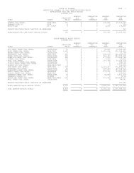
Reported production for <strong>the</strong> <strong>Brooklyn</strong> Field, through July 2012, is over 1.5 million<br />
barrels <strong>of</strong> oil <strong>and</strong> 1.4 billion cubic feet <strong>of</strong> gas.<br />
4