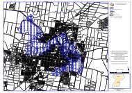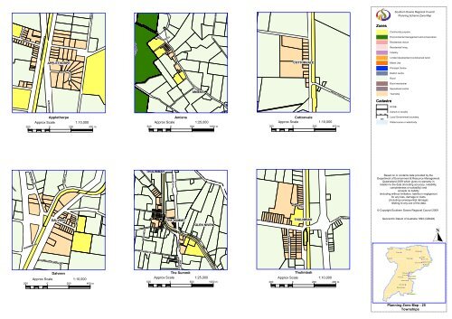
Zoning Maps 25 to 28 - Townships - Southern Downs Regional ...
Zoning Maps 25 to 28 - Townships - Southern Downs Regional ...
Zoning Maps 25 to 28 - Townships - Southern Downs Regional ...

Create successful ePaper yourself
Turn your PDF publications into a flip-book with our unique Google optimized e-Paper software.
<strong>Southern</strong> <strong>Downs</strong> <strong>Regional</strong> Council<br />
Planning Scheme Zone Map<br />
Zones<br />
APPLETHORPE<br />
COTTONVALE<br />
Community purpose<br />
Environmental management and conservation<br />
Residential choice<br />
Residential living<br />
Industry<br />
Limited development (constrained land)<br />
Mixed Use<br />
Principal Centre<br />
District centre<br />
Rural<br />
Rural residential<br />
AMIENS<br />
Specialised centre<br />
Township<br />
Cadastre<br />
DCDB<br />
Suburb or locality<br />
Applethorpe Amiens Cot<strong>to</strong>nvale<br />
Approx Scale<br />
1:10,000<br />
Approx Scale 1:<strong>25</strong>,000<br />
Approx Scale<br />
500 0 500 1000 m<br />
200 0 200 400 m<br />
1:10,000<br />
200 0 200 400 m<br />
Local Government boundary<br />
Watercourse or waterbody<br />
THULIMBAH<br />
Based on or contains data provided by the<br />
Department of Environment & Resource Management<br />
Queensland 2009 which gives no warranty in<br />
relation <strong>to</strong> the data (including accuracy, reliability,<br />
completeness or suitability) and<br />
accepts no liability<br />
(including without limitation, liability in negligence)<br />
for any loss, damage or costs<br />
(including consequential damage)<br />
relating <strong>to</strong> any use of the data.<br />
© Copyright <strong>Southern</strong> <strong>Downs</strong> <strong>Regional</strong> Council 2009<br />
DALVEEN<br />
THE SUMMIT<br />
GLEN NIVEN<br />
THULIMBAH<br />
Geocentric Datum of Australia 1994 (GDA94)<br />
<br />
Leyburn<br />
<br />
Pratten<br />
<br />
Allora<br />
<br />
Maryvale<br />
<br />
Karara<br />
<br />
Warwick<br />
<br />
Yangan<br />
<br />
<br />
Emu Vale<br />
<br />
Mount Colliery<br />
Tannymorel<br />
<br />
Killarney<br />
Dalveen The Summit Thulimbah<br />
Approx Scale<br />
1:10,000<br />
Approx Scale 1:<strong>25</strong>,000<br />
Approx Scale<br />
200 0 200 400 m<br />
500 0 500 1000 m<br />
1:10,000<br />
200 0 200 400 m<br />
<br />
Dalveen<br />
Cot<strong>to</strong>nvale<br />
<br />
Thulimbah<br />
<br />
<br />
The Summit<br />
Amiens <br />
<br />
Applethorpe<br />
Stanthorpe <br />
Glen Aplin <br />
Ballandean<br />
<br />
<br />
Wallangarra<br />
Planning Zone Map - <strong>25</strong><br />
<strong>Townships</strong>
<strong>Southern</strong> <strong>Downs</strong> <strong>Regional</strong> Council<br />
Planning Scheme Zone Map<br />
Zones<br />
SOMME<br />
FLETCHER<br />
Cadastre<br />
Community purpose<br />
Environmental management and conservation<br />
Residential choice<br />
Residential living<br />
Industry<br />
Limited development (constrained land)<br />
Mixed Use<br />
Principal Centre<br />
District centre<br />
Rural<br />
Rural residential<br />
Specialised centre<br />
Township<br />
DCDB<br />
Suburb or locality<br />
Local Government boundary<br />
Watercourse or waterbody<br />
BALLANDEAN<br />
WALLANGARRA<br />
SEVERN RIVER<br />
GLEN APLIN<br />
ACCOMMODATION CREEK<br />
FLETCHER<br />
Ballandean Glen Aplin Wallangarra<br />
Approx Scale 1:<strong>25</strong>,000<br />
500 0 500 1000 m<br />
Approx Scale 1:<strong>25</strong>,000<br />
500 0 500 1000 m<br />
Approx Scale 1:<strong>25</strong>,000<br />
500 0 500 1000 m<br />
Based on or contains data provided by the<br />
Department of Environment & Resource Management<br />
Queensland 2009 which gives no warranty in<br />
relation <strong>to</strong> the data (including accuracy, reliability,<br />
completeness or suitability) and<br />
accepts no liability<br />
(including without limitation, liability in negligence)<br />
for any loss, damage or costs<br />
(including consequential damage)<br />
relating <strong>to</strong> any use of the data.<br />
© Copyright <strong>Southern</strong> <strong>Downs</strong> <strong>Regional</strong> Council 2009<br />
Geocentric Datum of Australia 1994 (GDA94)<br />
<br />
Leyburn<br />
<br />
Pratten<br />
<br />
Allora<br />
<br />
Maryvale<br />
<br />
Karara<br />
<br />
Warwick<br />
<br />
Yangan<br />
<br />
<br />
Emu Vale<br />
<br />
Mount Colliery<br />
Tannymorel<br />
<br />
Killarney<br />
<br />
Dalveen<br />
Cot<strong>to</strong>nvale<br />
<br />
Thulimbah<br />
<br />
<br />
The Summit<br />
Amiens <br />
<br />
Applethorpe<br />
Stanthorpe <br />
Glen Aplin <br />
Ballandean <br />
<br />
Wallangarra<br />
Planning Zone Map - 26<br />
<strong>Townships</strong>
<strong>Southern</strong> <strong>Downs</strong> <strong>Regional</strong> Council<br />
Planning Scheme Zone Map<br />
ALLORA<br />
Zones<br />
MILLAR VALE CREEK<br />
MILLARVALE CREEK<br />
Community purpose<br />
Environmental management and conservation<br />
Residential choice<br />
Residential living<br />
EMU CREEK<br />
EMU VALE<br />
MARYVALE<br />
Industry<br />
Limited development (constrained land)<br />
Mixed Use<br />
HENDON<br />
Principal Centre<br />
District centre<br />
Rural<br />
Rural residential<br />
Specialised centre<br />
Township<br />
DEUCHAR<br />
Cadastre<br />
DCDB<br />
Suburb or locality<br />
Emu Vale Hendon Maryvale<br />
Approx Scale 1:<strong>25</strong>,000<br />
Approx Scale 1:<strong>25</strong>,000<br />
Approx Scale 1:<strong>25</strong>,000<br />
500 0 500 1000 m<br />
500 0 500 1000 m<br />
500 0 500 1000 m<br />
Local Government boundary<br />
Watercourse or waterbody<br />
FARM CREEK<br />
FARM CREEK<br />
Based on or contains data provided by the<br />
Department of Environment & Resource Management<br />
Queensland 2009 which gives no warranty in<br />
relation <strong>to</strong> the data (including accuracy, reliability,<br />
completeness or suitability) and<br />
accepts no liability<br />
(including without limitation, liability in negligence)<br />
for any loss, damage or costs<br />
(including consequential damage)<br />
relating <strong>to</strong> any use of the data.<br />
© Copyright <strong>Southern</strong> <strong>Downs</strong> <strong>Regional</strong> Council 2009<br />
MOUNT COLLIERY<br />
TANNYMOREL<br />
Geocentric Datum of Australia 1994 (GDA94)<br />
YANGAN<br />
SWAN CREEK<br />
<br />
Leyburn<br />
<br />
Pratten<br />
<br />
Allora<br />
<br />
Maryvale<br />
<br />
Karara<br />
<br />
Warwick<br />
<br />
Yangan<br />
<br />
<br />
Emu Vale<br />
<br />
Mount Colliery<br />
Tannymorel<br />
<br />
Killarney<br />
Mt Colliery Tannymorel Yangan<br />
Approx Scale<br />
1:10,000 Approx Scale<br />
1:10,000<br />
200 0 200 400 m<br />
200 0 200 400 m<br />
Approx Scale 1:<strong>25</strong>,000<br />
500 0 500 1000 m<br />
<br />
Dalveen<br />
Cot<strong>to</strong>nvale<br />
<br />
Thulimbah<br />
<br />
<br />
The Summit<br />
Amiens <br />
<br />
Applethorpe<br />
Stanthorpe <br />
Glen Aplin <br />
Ballandean<br />
<br />
<br />
Wallangarra<br />
Planning Zone Map - 27<br />
<strong>Townships</strong>
<strong>Southern</strong> <strong>Downs</strong> <strong>Regional</strong> Council<br />
Planning Scheme Zone Map<br />
Zones<br />
Community purpose<br />
Environmental management and conservation<br />
Residential choice<br />
Residential living<br />
Industry<br />
Limited development (constrained land)<br />
Mixed Use<br />
Principal Centre<br />
District centre<br />
Rural<br />
Rural residential<br />
Specialised centre<br />
Township<br />
CANAL CREEK<br />
Cadastre<br />
DCDB<br />
Suburb or locality<br />
Local Government boundary<br />
Watercourse or waterbody<br />
KARARA<br />
LEYBURN<br />
PRATTEN<br />
Approx Scale<br />
CANAL CREEK<br />
Karara Leyburn Pratten<br />
1:10,000<br />
200 0 200 400 m<br />
Approx Scale 1:<strong>25</strong>,000<br />
500 0 500 1000 m<br />
Approx Scale 1:<strong>25</strong>,000<br />
500 0 500 1000 m<br />
Based on or contains data provided by the<br />
Department of Environment & Resource Management<br />
Queensland 2009 which gives no warranty in<br />
relation <strong>to</strong> the data (including accuracy, reliability,<br />
completeness or suitability) and<br />
accepts no liability<br />
(including without limitation, liability in negligence)<br />
for any loss, damage or costs<br />
(including consequential damage)<br />
relating <strong>to</strong> any use of the data.<br />
© Copyright <strong>Southern</strong> <strong>Downs</strong> <strong>Regional</strong> Council 2009<br />
Geocentric Datum of Australia 1994 (GDA94)<br />
<br />
Leyburn<br />
<br />
Pratten<br />
<br />
Allora<br />
<br />
Maryvale<br />
<br />
Karara<br />
<br />
Warwick<br />
<br />
Yangan<br />
<br />
<br />
Emu Vale<br />
<br />
Mount Colliery<br />
Tannymorel<br />
<br />
Killarney<br />
<br />
Dalveen<br />
Cot<strong>to</strong>nvale<br />
<br />
Thulimbah<br />
<br />
<br />
The Summit<br />
Amiens <br />
<br />
Applethorpe<br />
Stanthorpe <br />
Glen Aplin <br />
Ballandean <br />
<br />
Wallangarra<br />
Planning Zone Map - <strong>28</strong><br />
<strong>Townships</strong>