Flood hazard Overlay - Southern Downs Regional Council
Flood hazard Overlay - Southern Downs Regional Council
Flood hazard Overlay - Southern Downs Regional Council
- No tags were found...

Create successful ePaper yourself
Turn your PDF publications into a flip-book with our unique Google optimized e-Paper software.
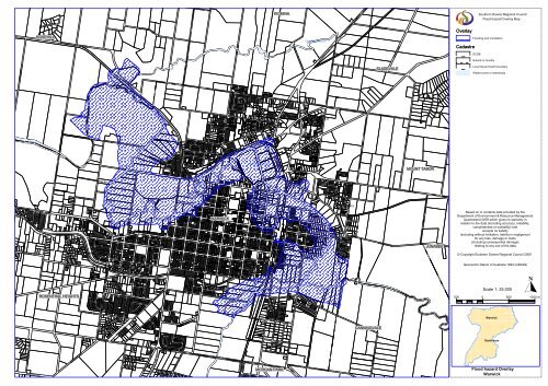
WOMINA<strong>Southern</strong> <strong>Downs</strong> <strong>Regional</strong> <strong>Council</strong><strong>Flood</strong> <strong>hazard</strong> <strong>Overlay</strong> MapROSEHILLCAMPBELL GULLY<strong>Overlay</strong>Cadastre<strong>Flood</strong>ing and inundationDCDBSuburb or localitySLADEVALELocal Government boundaryWatercourse or waterbodyCONDAMINE RIVERMOUNT TABORWARWICKJUNABEEBased on or contains data provided by theDepartment of Environment & Resource ManagementQueensland 2009 which gives no warranty inrelation to the data (including accuracy, reliability,completeness or suitability) andaccepts no liability(including without limitation, liability in negligence)for any loss, damage or costs(including consequential damage)relating to any use of the data.© Copyright <strong>Southern</strong> <strong>Downs</strong> <strong>Regional</strong> <strong>Council</strong> 2009Geocentric Datum of Australia 1994 (GDA94)BRACKER CREEKScale 1: 25,000ROSENTHAL HEIGHTSBRACKER CREEKROSENTHAL CREEK500 0 500 1000 mWarwickCANNINGVALEStanthorpeMORGAN PARK<strong>Flood</strong> <strong>hazard</strong> <strong>Overlay</strong>Warwick
<strong>Southern</strong> <strong>Downs</strong> <strong>Regional</strong> <strong>Council</strong><strong>Flood</strong> <strong>hazard</strong> <strong>Overlay</strong> Map<strong>Overlay</strong>Cadastre<strong>Flood</strong>ing and inundationDCDBSuburb or localityLocal Government boundaryWatercourse or waterbodySTANTHORPEQUART POT CREEKBased on or contains data provided by theDepartment of Environment & Resource ManagementQueensland 2009 which gives no warranty inrelation to the data (including accuracy, reliability,completeness or suitability) andaccepts no liability(including without limitation, liability in negligence)for any loss, damage or costs(including consequential damage)relating to any use of the data.© Copyright <strong>Southern</strong> <strong>Downs</strong> <strong>Regional</strong> <strong>Council</strong> 2009Geocentric Datum of Australia 1994 (GDA94)Scale 1: 10,000200 0 200 400 mDIAMONDVALEWarwickStanthorpe<strong>Flood</strong> <strong>hazard</strong> <strong>Overlay</strong>Stanthorpe