de la serra de mariola - Parques Naturales - Generalitat Valenciana
de la serra de mariola - Parques Naturales - Generalitat Valenciana
de la serra de mariola - Parques Naturales - Generalitat Valenciana

You also want an ePaper? Increase the reach of your titles
YUMPU automatically turns print PDFs into web optimized ePapers that Google loves.
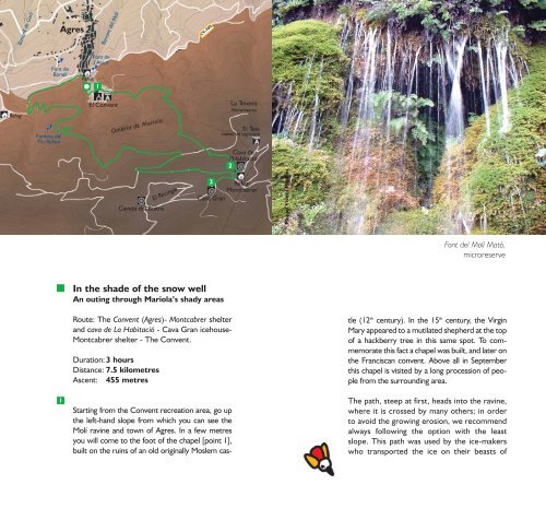
Barranc <strong>de</strong> Garlí<br />
Agres<br />
Barranc <strong>de</strong>l Molí<br />
CV-700<br />
Font <strong>de</strong><br />
Bonell<br />
Font <strong>de</strong><br />
l’Assut<br />
Refugi<br />
1<br />
Refugi<br />
Fonteta <strong>de</strong>l<br />
Tio Rufino<br />
El Convent<br />
Ombria <strong>de</strong> Mario<strong>la</strong><br />
La Teixera<br />
Microreserva<br />
El Teix<br />
caseta <strong>de</strong> vigi<strong>la</strong>ncia<br />
Cava <strong>de</strong><br />
l’Habitació<br />
2<br />
Caveta <strong>de</strong>l Buitre<br />
El Recingle<br />
3 Refugi<br />
Montcabrer<br />
Cava Gran<br />
Miquel Vives i Miralles<br />
Font <strong>de</strong>l Molí Mató,<br />
microreserve<br />
.<br />
In the sha<strong>de</strong> of the snow well<br />
An outing through Mario<strong>la</strong>’s shady areas<br />
1<br />
Route: The Convent (Agres)- Montcabrer shelter<br />
and cava <strong>de</strong> La Habitació - Cava Gran icehouse-<br />
Montcabrer shelter - The Convent.<br />
Duration: 3 hours<br />
Distance: 7.5 kilometres<br />
Ascent: 455 metres<br />
Starting from the Convent recreation area, go up<br />
the left-hand slope from which you can see the<br />
Molí ravine and town of Agres. In a few metres<br />
you will come to the foot of the chapel [point 1],<br />
built on the ruins of an old originally Moslem cas-<br />
tle (12 th century). In the 15 th century, the Virgin<br />
Mary appeared to a muti<strong>la</strong>ted shepherd at the top<br />
of a hackberry tree in this same spot. To commemorate<br />
this fact a chapel was built, and <strong>la</strong>ter on<br />
the Franciscan convent. Above all in September<br />
this chapel is visited by a long procession of people<br />
from the surrounding area.<br />
The path, steep at first, heads into the ravine,<br />
where it is crossed by many others; in or<strong>de</strong>r<br />
to avoid the growing erosion, we recommend<br />
always following the option with the least<br />
slope. This path was used by the ice-makers<br />
who transported the ice on their beasts of