de la serra de mariola - Parques Naturales - Generalitat Valenciana
de la serra de mariola - Parques Naturales - Generalitat Valenciana
de la serra de mariola - Parques Naturales - Generalitat Valenciana

You also want an ePaper? Increase the reach of your titles
YUMPU automatically turns print PDFs into web optimized ePapers that Google loves.
<strong>de</strong> <strong>la</strong> <strong>serra</strong><br />
<strong>de</strong> mario<strong>la</strong><br />
English version
Parc Natural <strong>de</strong> <strong>la</strong> Serra <strong>de</strong> Mario<strong>la</strong><br />
<strong>serra</strong>_mario<strong>la</strong>@gva.es<br />
Mas dUll <strong>de</strong> Canals<br />
Ctra. Alcoi-Banyeres, km 17.5<br />
Apartado <strong>de</strong> correos 157<br />
13450 Banyeres <strong>de</strong> Mario<strong>la</strong> (A<strong>la</strong>cant)<br />
Tel. 965 56 63 83<br />
http://parquesnaturales.gva.es<br />
Assistance from:<br />
Printing this material has been possible thanks to the Cooperation Agreement<br />
signed on 21st April 2006 by the Caja <strong>de</strong> Ahorros y Pensiones <strong>de</strong> Barcelona, "<strong>la</strong> Caixa"<br />
and the <strong>Generalitat</strong> <strong>Valenciana</strong> (Autonomous Community Authority) for Un<strong>de</strong>rtaking<br />
the Integral Management P<strong>la</strong>n for Conservation of the Natural Systems of the<br />
Valencian Community’s Network of Nature Reserves.<br />
Layout:<br />
Photography:<br />
Map Design:<br />
Texts:<br />
Printed:<br />
Legal Deposit:<br />
Benjamín Albiach Galán<br />
Kun.Xusa Beltrán<br />
Benjamín Albiach Galán<br />
Núria Lara Bernàcer<br />
Miquel Vives i Miralles<br />
G. B.<br />
Pau Pérez Puigcerver<br />
source: ICV (Cartographic Institute of Valencia)<br />
Environmental educacion team<br />
Centro Especial <strong>de</strong> Empleo, IVADIS
Date of PORN approval:<br />
2nd April 2001<br />
Date on which it was <strong>de</strong>c<strong>la</strong>red a Nature Reserve:<br />
8th gener 2002<br />
Municipalities insi<strong>de</strong> the Reserve:<br />
Shared by Agres (723 m), Alcoy (560 m),<br />
Alfafara (582 m), Banyeres <strong>de</strong> Mario<strong>la</strong> (816 m),<br />
Bocairent (641 m), Cocentaina (435 m) and<br />
Muro d'Alcoy (399 m), it has a rugged relief and<br />
major contour differences, above all to the NE<br />
(Montcabrer, 1390 m).<br />
The Sierra <strong>de</strong> Mario<strong>la</strong> mountain range, whose<br />
area of over 16,000 hectares was <strong>de</strong>c<strong>la</strong>red a<br />
nature reserve on 8th January 2002, spreads over<br />
the Vall d'Albaida, l'Alcoià and El Comtat counties,<br />
and is one of the most well-established reserves<br />
in Valencian popu<strong>la</strong>r culture.<br />
Some prominent features of the area are the<br />
many springs, country houses and a criss-crossing<br />
paths all over it, which vouch for all the hard<br />
work done taking advantage of the natural<br />
resources by its former settlers - ice-<strong>de</strong>alers,<br />
shepherds, woodcutters and others - who ma<strong>de</strong><br />
their living from this <strong>la</strong>nd.<br />
These are all reasons why the Sierra <strong>de</strong> Mario<strong>la</strong>, a<br />
real natural paradise in which there is a wealth of<br />
floral species unequalled in the whole Valencian<br />
Region, has become something that the local people<br />
fully i<strong>de</strong>ntify themselves with and a major <strong>la</strong>ndmark<br />
whose attractions continue to appeal to<br />
generations of hikers and day-trippers.
Human heritage<br />
Countless archaeological findings bear witness<br />
to man’s presence in the range since times<br />
immemorial, mainly to the SE and in the proximity<br />
of Vinalopó, with numerous paintings and<br />
remains of mainly Neolithic, Bronze age and<br />
Iberian settlements.<br />
An unquestionable symbol of these areas are the<br />
cavas (snow well) – cel<strong>la</strong>rs or vaults used from the<br />
16th to the 20th centuries for storing snow, transforming<br />
this into ice by compacting it and then<br />
selling it in summer; transporting this to nearby<br />
counties for use in preserving food, making icecreams<br />
or for therapeutic purposes.<br />
Other characteristic features of the human<br />
influence on this <strong>la</strong>ndscape are the masías - selfsufficient<br />
country farmsteads, farming and<br />
forestry units generally run by a single family,<br />
based on cultivating unirrigated <strong>la</strong>nd and stockbreeding.<br />
There are also <strong>de</strong>fensive buildings -<br />
castles, spread over the peaks of the range, and<br />
religious buildings - chapels.<br />
B. Albiach Galán<br />
Cava Arquejada and the<br />
Montcabrer peak
Geology<br />
In this huge limestone mass, which originated in<br />
the Cretaceous age, when the zone coinci<strong>de</strong>d<br />
with the edge of a sedimentary marine basin,<br />
there are major pa<strong>la</strong>eontological sites such as<br />
the one in Quero<strong>la</strong>, as well as outcrops of<br />
materials (c<strong>la</strong>ys) proper to the Triassic age,<br />
Keuper period.<br />
Karstic processes (dissolution of limestone rocks<br />
by water) are what have mostly <strong>de</strong>termined the<br />
present morphology of the range, with emblematic<br />
formations such as the Cint ravine or the<br />
Sarsa cave.<br />
Climate<br />
Mario<strong>la</strong> enjoys a typically Mediterranean climate,<br />
with a fairly <strong>la</strong>rge range of microclimates, and<br />
major differences <strong>de</strong>pending on the direction the<br />
<strong>la</strong>nd faces and its altitu<strong>de</strong>.<br />
Most of the rainfall is on the northern and western<br />
faces, while the extreme southeast has the<br />
most continental climate. Snow tends to be frequent<br />
in winter, above all in the higher parts and<br />
more exceptionally in spring.<br />
The higher zones of the range are subject to <strong>la</strong>rge<br />
amounts of mist and <strong>de</strong>w, rainfall that cannot be<br />
quantified but is not insignificant, especially for the<br />
vegetation.<br />
The Montcabrer from The Penyes Monteses<br />
The snow is in the habit of being frequent in<br />
the high levels of the Nature Reserve<br />
B. Allbiach Galán<br />
B. Allbiach Galán
P<strong>la</strong>nt life<br />
Mario<strong>la</strong>, with its over 1400 vascu<strong>la</strong>r p<strong>la</strong>nts, is<br />
doubtlessly a marvellous example of the biodiversity<br />
of species and settings. It is famous for the<br />
ones with aromatic and medicinal properties:<br />
Mario<strong>la</strong> sage, camomile, thyme, cat’s tail, hypericum,<br />
rock tea,... and for other ethno-botanical<br />
uses that have been ma<strong>de</strong> of them since ancient<br />
times; for preparing drinks, as a culinary condiment,<br />
as a remedy for all kinds of comp<strong>la</strong>ints,<br />
preparing perfumes, and others.<br />
In Mario<strong>la</strong> one can find anything from areas<br />
<strong>de</strong>gra<strong>de</strong>d by fires to good examples of potential<br />
climacic vegetation: the holm oak grove, and in<br />
shady areas, mixed Mediterranean woods,<br />
accompanied by kermes oaks, Mediterranean<br />
mezereon, junipers, evergreen buckthorn, etc..<br />
Most of the range is however covered with pine<br />
trees and thickets with briar, heather, rockrose…<br />
and there are also some good examples of edaphic<br />
vegetation in the Vinalopó area, and major p<strong>la</strong>nt<br />
communities associated with springs (such as that<br />
of Molí Mató).<br />
The “Teixera d’Agres” yew tree grove is a major<br />
feature, still containing some extraordinary specimens<br />
of this remarkable magic tree.<br />
Mario<strong>la</strong> sage<br />
(Salvia b<strong>la</strong>ncoana subsp. mariolensis)<br />
Núria Lara Bernàcer
B. Albiach Galán<br />
Gol<strong>de</strong>n eagle<br />
Fauna<br />
The great variety of environments also entails a<br />
major diversity of fauna. There are thus insects<br />
and many other invertebrates, amphibians (frogs<br />
and toads) reptiles, (Iberian wall lizard and <strong>la</strong>rge<br />
Psammodromus, ocel<strong>la</strong>ted lizard, Montpellier<br />
snake, Lataste’s viper...), birds (finch, partridge,<br />
serin, robin, common tit...; daytime birds of prey:<br />
gol<strong>de</strong>n eagle, peregrine falcon, goshawk...; nocturnal<br />
birds: imperial owl, spotted owl, barn<br />
owl...) and mammals (boar, rabbit, wild cat, stone<br />
marten, weasel, genet, badger, fox...), colonising<br />
woods, meadows, cliffs, caves, rivers, ponds<br />
farm<strong>la</strong>nd and even urban centres.<br />
Fox<br />
B. Albiach Galán
Sant Cristòfol<br />
Barranc <strong>de</strong>l Cint<br />
Barranquet <strong>de</strong> Ferri<br />
L’Horteta<br />
<strong>de</strong>l Pobre<br />
1<br />
2<br />
La Creu<br />
Ermita <strong>de</strong><br />
Sant Cristòfol<br />
Bara<strong>de</strong>ro<br />
<strong>de</strong> Moia<br />
Font <strong>de</strong> Moia<br />
El Preventori<br />
Barranquet <strong>de</strong> Soler<br />
Alcoi<br />
N-340<br />
Miquel Vives i Miralles<br />
Sant Cristòfol chapel<br />
.<br />
Vantage points in the sun<br />
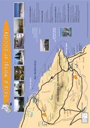
Route: An outing to Sant Cristòfol Cross<br />
Route: Preventorio (Alcoy)- La Horteta <strong>de</strong>l Pobre -<br />
Sant Cristòfol chapel and cross- La Horteta.<br />
Duration: 1 hour<br />
Distance: 2 kilometres<br />
Ascent: 170 metres<br />
The route starts in El Preventorio recreation area.<br />
The building with the same name was built in the<br />
1950s as a hospital for children with tuberculosis.<br />
Years <strong>la</strong>ter it became a resi<strong>de</strong>nce for orphans and<br />
is an old people’s home today.<br />
1<br />
2<br />
The path starts by the <strong>la</strong>rge pond and heads into the<br />
ravine, towards the Horteta <strong>de</strong>l Pobre [point 1],<br />
with barbecue facilities, tables, spring and a woo<strong>de</strong>n<br />
bridge, all in a nicely prepared cool area. There<br />
are many paths leading to the top – at an altitu<strong>de</strong> of<br />
921 m, with the cross and Sant Cristòfol chapel<br />
[point 2], which is what gives its name to this public<br />
area – so the most convenient option should be<br />
taken to avoid the proliferation of new shortcuts<br />
and to reduce the erosion process on the slope;<br />
head up through the pines where there is a covering<br />
of perennial grass and the odd savin juniper; also<br />
rosemary bushes, b<strong>la</strong>ckthorn, salvia cistus, hipericum<br />
ericoi<strong>de</strong>s, evergreen buckthorn...<br />
With a little luck you will be accompanied on<br />
the way by the majestic flight of the griffon vulture,<br />
a species which has colonised the cliffs of
the Cint ravine and surroundings, thanks to a<br />
reintroduction scheme (Canyet Project). The<br />
present chapel, restored some years ago, is a<br />
20 th century building constructed on an early<br />
14 th century one: besi<strong>de</strong> it there is a cistern<br />
and the <strong>la</strong>rge iron cross, either metres high,<br />
that can be seen a long way off, and was built<br />
in the 1950s to rep<strong>la</strong>ce the original woo<strong>de</strong>n<br />
one, ma<strong>de</strong> in 1903, which was <strong>de</strong>stroyed<br />
during the Civil War.<br />
From this won<strong>de</strong>rful vantage point one can see<br />
the city of Alcoy and surrounding mountain<br />
ranges: La Serreta, Els P<strong>la</strong>ns, Carrascal <strong>de</strong> <strong>la</strong> Font<br />
Roja, the Almudaina range, Serrel<strong>la</strong>, Aitana and<br />
the Puig Campana. To the north you will be surprised<br />
by the Cint ravine and the foothills of<br />
Mario<strong>la</strong>, with Cocentaina and its castle and<br />
mount Benica<strong>de</strong>ll in the background - Beniarrés<br />
reservoir at its feet – and the distant Safor<br />
mountains; to the west, El Castel<strong>la</strong>r and the<br />
green fields of Bara<strong>de</strong>llo.<br />
We should stress that the whole area, chapel,<br />
paths and surroundings, have been prepared<br />
through the anonymous and uninterested<br />
en<strong>de</strong>avours of many retired resi<strong>de</strong>nts of Alcoy,<br />
lovers of the mountains and who have year<br />
after year ma<strong>de</strong> this p<strong>la</strong>ce their own and<br />
everyone else’s home.<br />
The way back to the starting point is by a less<br />
steeply-sloping path which you should leave<br />
before reaching Bara<strong>de</strong>llo <strong>de</strong> Moia to go back<br />
to the beginning in a fast and easy <strong>de</strong>scent.<br />
B. Albiach Galán<br />
Barranc <strong>de</strong>l Cint
Barranc <strong>de</strong> Garlí<br />
Agres<br />
Barranc <strong>de</strong>l Molí<br />
CV-700<br />
Font <strong>de</strong><br />
Bonell<br />
Font <strong>de</strong><br />
l’Assut<br />
Refugi<br />
1<br />
Refugi<br />
Fonteta <strong>de</strong>l<br />
Tio Rufino<br />
El Convent<br />
Ombria <strong>de</strong> Mario<strong>la</strong><br />
La Teixera<br />
Microreserva<br />
El Teix<br />
caseta <strong>de</strong> vigi<strong>la</strong>ncia<br />
Cava <strong>de</strong><br />
l’Habitació<br />
2<br />
Caveta <strong>de</strong>l Buitre<br />
El Recingle<br />
3 Refugi<br />
Montcabrer<br />
Cava Gran<br />
Miquel Vives i Miralles<br />
Font <strong>de</strong>l Molí Mató,<br />
microreserve<br />
.<br />
In the sha<strong>de</strong> of the snow well<br />
An outing through Mario<strong>la</strong>’s shady areas<br />
1<br />
Route: The Convent (Agres)- Montcabrer shelter<br />
and cava <strong>de</strong> La Habitació - Cava Gran icehouse-<br />
Montcabrer shelter - The Convent.<br />
Duration: 3 hours<br />
Distance: 7.5 kilometres<br />
Ascent: 455 metres<br />
Starting from the Convent recreation area, go up<br />
the left-hand slope from which you can see the<br />
Molí ravine and town of Agres. In a few metres<br />
you will come to the foot of the chapel [point 1],<br />
built on the ruins of an old originally Moslem cas-<br />
tle (12 th century). In the 15 th century, the Virgin<br />
Mary appeared to a muti<strong>la</strong>ted shepherd at the top<br />
of a hackberry tree in this same spot. To commemorate<br />
this fact a chapel was built, and <strong>la</strong>ter on<br />
the Franciscan convent. Above all in September<br />
this chapel is visited by a long procession of people<br />
from the surrounding area.<br />
The path, steep at first, heads into the ravine,<br />
where it is crossed by many others; in or<strong>de</strong>r<br />
to avoid the growing erosion, we recommend<br />
always following the option with the least<br />
slope. This path was used by the ice-makers<br />
who transported the ice on their beasts of
B. Albiach Galán<br />
El Teix<br />
2<br />
bur<strong>de</strong>n to the vil<strong>la</strong>ges in these counties. Then go<br />
on up through the Mediterranean thickets of<br />
Aleppo pines while you enjoy the panorama<br />
behind you.<br />
Cross a forest path which leads to La Teixera<br />
d’Agres, continue along the track until you come<br />
up to El Teix ice-house (18 th century) which may<br />
go unnoticed through being almost covered by<br />
ivy. A little further on you will reach Montcabrer<br />
shelter, built in 1975 on the remains of the former<br />
Habitació house [point 2], where the ice-<strong>de</strong>alers<br />
who worked in the zone spent the night during<br />
the snow collecting period. In a few metres you<br />
will come to the cava known as La Habitació<br />
(18th century) which still keeps its masonry dome<br />
3<br />
almost intact. Right at the top of El Teix is the<br />
lookout hut. This point has an outstanding view:<br />
Montcabrer, Recingle, <strong>la</strong> Valleta d’Agres, the<br />
counties of the Vall d’Albaida and La Costera,<br />
Benica<strong>de</strong>ll, Beniarrés reservoir and La Safor in the<br />
background; Albureca, Almudaina, the Serrel<strong>la</strong><br />
and Aitana.<br />
Go on along the path by the forest road southeast<br />
towards Cava Gran ice-house (also known as<br />
Cava Arquejada), an obvious symbol of this range.<br />
Built from the 17 th to 18 th centuries, it was in use<br />
until the early 20 th century, and again used at<br />
times during the Civil war. It is 11 m <strong>de</strong>ep with a<br />
15 m internal diameter, three arches crossing in
N-340<br />
Agres<br />
Pob<strong>la</strong>do Ibérico<br />
<strong>de</strong> <strong>la</strong> Mo<strong>la</strong><br />
Penya <strong>de</strong>l Frare<br />
Bocairent<br />
CV-81<br />
Morro <strong>de</strong>l Porc<br />
962<br />
Ermita <strong>de</strong><br />
Sant Jaume<br />
Rio Vinalopó<br />
Cova <strong>de</strong><br />
<strong>la</strong> Sarsa<br />
Ermita <strong>de</strong><br />
Sta. Bárbaral<br />
Font <strong>de</strong>l P<strong>la</strong><br />
Font <strong>de</strong>l<br />
Tarragó<br />
CV-794<br />
Alfafara<br />
Alt <strong>de</strong> <strong>la</strong> Cova<br />
el Portín<br />
1087<br />
A. R. Font <strong>de</strong><br />
Mario<strong>la</strong><br />
A. R. Font <strong>de</strong>l<br />
Moli Mató<br />
Cava <strong>de</strong> D.<br />
Miguel<br />
Castell <strong>de</strong><br />
Mario<strong>la</strong><br />
Font <strong>de</strong><br />
Mario<strong>la</strong><br />
Cava Gran<br />
Caveta <strong>de</strong>l<br />
Buitgre<br />
Alt <strong>de</strong> <strong>la</strong> Codol<strong>la</strong><br />
1169<br />
el Teix<br />
1261<br />
Bnc. <strong>de</strong>l Bou<br />
Font <strong>de</strong> <strong>la</strong><br />
Boronada<br />
Balcó <strong>de</strong><br />
Llopis<br />
Montcabrer<br />
1390<br />
Penyes Monteses<br />
1354<br />
A. R. Font les<br />
Huit Piletes<br />
Pob<strong>la</strong>do Ibérico<br />
<strong>de</strong> l’Alberri<br />
Ermita <strong>de</strong><br />
Sta Bárbara<br />
Refugi les Foietes<br />
Muro<br />
Ermita <strong>de</strong><br />
Sant Cristòfol<br />
Pic Negre<br />
912<br />
Cocentaina<br />
Castell <strong>de</strong>l Vinalopó<br />
Pob<strong>la</strong>t <strong>de</strong>l Bronze<br />
<strong>de</strong> <strong>la</strong> Mo<strong>la</strong> Alta<br />
Banyeres<br />
<strong>de</strong> Mario<strong>la</strong><br />
Font <strong>de</strong><br />
<strong>la</strong> Burra<br />
Font <strong>de</strong> <strong>la</strong><br />
Coveta<br />
Montes<br />
<strong>de</strong> Ro<strong>de</strong>no<br />
Font Freda<br />
l’Eixarc<br />
1094<br />
Barxell<br />
Urb.<br />
Sargento<br />
Urb.<br />
Bara<strong>de</strong>llo<br />
Ge<strong>la</strong>t<br />
Barranc <strong>de</strong>l Cint<br />
Cova <strong>de</strong>l Conill<br />
Ermita i creu <strong>de</strong><br />
Sant Cristòfol<br />
Alcoi<br />
CV-795<br />
Urb.<br />
Montesol<br />
Ermita i castell<br />
<strong>de</strong> Barxell<br />
N-340<br />
Ermita<br />
<strong>de</strong> Polop<br />
E: 1/100.000<br />
0 2.000<br />
4.000<br />
8.000 m<br />
carretera<br />
senda<br />
límite administrativo<br />
construcciones<br />
PORN (P<strong>la</strong>nning scheme of Natural Resources)<br />
Route: An outing to Sant Cristòfol Cross<br />
An outing through Mario<strong>la</strong>’s shady areas<br />
An outing along the head of the River Vinalopó<br />
Route: An outing through Comtat county
the centre, in line with the vertices of the outer<br />
hexagon. This structure held up the beam and<br />
thatched-<strong>la</strong>tticework vault, finished off with Arab<br />
tiles. Insi<strong>de</strong> it you will see a sturdy yew tree.<br />
Nearby there is a spring by the access tunnel.<br />
This high point is the priority habitat of many<br />
birds such as the crow, the wheatear, or the<br />
Alpine accentor, apart from birds of prey such as<br />
the kestrel or gol<strong>de</strong>n eagle<br />
Go back along your track to the shelter and take<br />
the forest track that drops down to the left, to the<br />
north-east, where you will find juniper, kermes<br />
oak, briar, thyme, Mario<strong>la</strong> sage or hedgehog<br />
broom. As you go back down you may find traces<br />
of stone martens, foxes or boars. Go by Tío<br />
Rufino spring to end up crossing an asphalted<br />
track which leads on the left to the Fuente <strong>de</strong>l<br />
Molí Mató recreation area. To return to the starting<br />
point go to the right and continue along the<br />
Convent path, f<strong>la</strong>nked by huge cypresses which<br />
welcome you back, walking along in front of the<br />
cavities known as the Bou Caves.<br />
Cava Gran (Agres)<br />
Santuari <strong>de</strong> <strong>la</strong> mare <strong>de</strong> Déu<br />
<strong>de</strong>l Castell/el Convent (Agres)<br />
B. Albiach Galán<br />
B. Albiach Galán
Font <strong>de</strong> <strong>la</strong> Coveta<br />
3<br />
Mas <strong>de</strong> Galbis<br />
B<strong>la</strong>nes (Molí <strong>de</strong><br />
Dalt i <strong>de</strong> Baix) 2<br />
La Borrera<br />
(Molí Campana)<br />
1<br />
Montes <strong>de</strong> Ro<strong>de</strong>no<br />
Mas <strong>de</strong> les Monges<br />
Molí Nou<br />
Font <strong>de</strong><br />
<strong>la</strong> Burra<br />
Casetes <strong>de</strong> l’Ansari<br />
Rio Vinalopó<br />
CV-795<br />
El Buixcarró<br />
Núria Lara Barnàcer<br />
Information centre “Ull <strong>de</strong> Canals”<br />
.<br />
The Water way. An outing along the head<br />
of the River Vinalopó<br />
Route: Mas d’Ull <strong>de</strong> Canals farmstead (Banyeres <strong>de</strong><br />
Mario<strong>la</strong>)- La Borrera (Molí Campana)- B<strong>la</strong>nes factory<br />
(Molino <strong>de</strong> Baix y <strong>de</strong> Dalt)- Fuente <strong>de</strong> <strong>la</strong><br />
Coveta spring - Mas d’Ull <strong>de</strong> Canals farmstead<br />
Duration: 1 hour 45 minutes<br />
Distance: 6.5 kilometres<br />
Ascent: 20 metres<br />
This route goes along the upstream stretch of the<br />
river Vinalopó, with water as its salient feature,<br />
through countrysi<strong>de</strong> characterised by riverbank<br />
ecosystems, hazelnut trees and market gar<strong>de</strong>ns, apart<br />
from items connected with making use of water:<br />
ponds, canals, dams and mills used at old factories.<br />
1<br />
The route starts at the farmstead known as Mas<br />
d’Ull <strong>de</strong> Canals, taking the forest path appearing<br />
to your left that will then be followed almost to<br />
the end of the route. On the left you will see terraces<br />
of olives and almonds, and quite a few little<br />
houses scattered around the area known as El<br />
Ansarí. To the right, the prevalent vegetation is<br />
bushes with pine trees. Ahead of you Vinalopó<br />
castle comes increasingly into view and while you<br />
walk you will be able to see the effects of the <strong>de</strong>vastating<br />
fire in 1994 on the nearby slopes.<br />
Going on between the terraces, after about 2.5<br />
kilometres from the start, you will reach the<br />
Campana mill [point 1], with its characteristic
Miquel Vives i Miralles<br />
B<strong>la</strong>nes factory (Molino <strong>de</strong> Baix y <strong>de</strong> Dalt)<br />
chimney. In the beginning, in 1712, the building<br />
was <strong>de</strong>signed as a flour mill; <strong>la</strong>ter on, in 1810, it<br />
was converted into a paper mill (a full-scale factory<br />
complex, famous for its smoking paper)<br />
and finally -between 1855 and 1968- it was<br />
transformed for production in the textile sector.<br />
The track goes on in parallel to the river, through<br />
the pretty riverbank wood ma<strong>de</strong> up of pop<strong>la</strong>rs,<br />
willows, reeds and other species, accompanied by<br />
the flight of gol<strong>de</strong>n orioles, nightingales, robins<br />
and other birds which brighten up the way with<br />
their lively colours and pleasant song.<br />
2<br />
Head on upstream until you come to the series<br />
of factories in B<strong>la</strong>nes [point 2]: originally set up<br />
as flour mills (<strong>la</strong>ter 18th century) and turned<br />
B<strong>la</strong>nes chimney<br />
Núria Lara Bernàcer
Núria Lara Barnàcer<br />
The Vinalopó River<br />
3<br />
into the paper sector from the early 19 th century<br />
until 1942.<br />
Cross the river and go on up the path that leads<br />
through the interior of the riverbank forest, the<br />
habitat of <strong>la</strong>rge numbers of creatures such as the<br />
common frog, the viperine snake, or some wellconcealed<br />
trout. As you walk along by holm oaks,<br />
willows and some climbing p<strong>la</strong>nts, it will not take<br />
long to get to La Coveta spring [point 3]: a cavity<br />
around two metres high in a little <strong>de</strong>ll to the right<br />
of the path. This has traditionally been consi<strong>de</strong>red<br />
as the birth of the Vinalopó, though in actual fact<br />
the water comes from Els Brulls, or even from an<br />
area further up, close to the Mas <strong>de</strong> Bodí.<br />
What is in<strong>de</strong>ed true is that the water permanently<br />
comes to the surface in this spring, thus<br />
creating a real river of life. The water goes on its<br />
way through Sax, Elda, close to the Sierra <strong>de</strong><br />
Crevillent range, crossing Elche and disappearing<br />
before reaching the sea. This covers a total of 92<br />
km with little flow, as the river has since ancient<br />
times been used as the driving force of textile<br />
and paper factories, and also for irrigating the<br />
crops on its banks.<br />
To go back, head directly along the forest track<br />
towards the factories and from there to the surroundings<br />
of the Mas d’Ull in Canals.
FFCC Alcoi<br />
Ermita <strong>de</strong> Sant Cristòfol<br />
N-340<br />
- Xátiva - Valencia<br />
Cova <strong>de</strong>l<br />
Balconet<br />
Cocentaina<br />
Mas <strong>de</strong><br />
l’Alberri<br />
el Fabricant<br />
El Castell<br />
Penyeta<br />
B<strong>la</strong>nca<br />
TUNEL<br />
Pa<strong>la</strong>u<br />
Comtal<br />
P<strong>la</strong> <strong>de</strong><br />
<strong>la</strong> Font<br />
apea<strong>de</strong>ro<br />
Ermita <strong>de</strong><br />
Sta. Bàrbara<br />
Miquel Vives i Miralles<br />
recreation area<br />
Ermita <strong>de</strong> Sant Cristòfol (Cocentaina)<br />
3<br />
A date with history<br />
Route: An outing through Comtat county<br />
Route: Pa<strong>la</strong>u Comtal (Cocentaina)- El Raval-<br />
Santa Bàrbara Chapel – Cocentaina Castle- Sant<br />
Cristòfol Chapel- P<strong>la</strong> <strong>de</strong> <strong>la</strong> Font- La Vi<strong>la</strong>- Pa<strong>la</strong>u<br />
Comtal.<br />
Duration: 1 hour 45 minutes<br />
Distance: 4.5 kilometres<br />
Ascent: 265 metres<br />
The route starts at the Pa<strong>la</strong>u Comtal, a Gothicrenaissance<br />
pa<strong>la</strong>ce of great artistic and architectural<br />
quality, built over a former 12 th century<br />
Moslem building at the or<strong>de</strong>rs of Roger <strong>de</strong> Lauria,<br />
the first feudal lord of the town.<br />
1<br />
The walks sets off from the P<strong>la</strong>ça <strong>de</strong>l Mercat,<br />
along the alleys in the former Moslem district<br />
of the Raval, with their peculiar winding <strong>la</strong>yout<br />
among low, narrow houses. Go on along Calle<br />
<strong>de</strong>l Forn and El Salvador church, until you come<br />
to the cross, from which you will follow a concrete<br />
path as far as Santa Bàrbara Chapel recreation<br />
area [point 1]: this is a “conquista” type<br />
building dating back to the second half of the<br />
13 th century. Go on, crossing the road, to take a<br />
path by an electricity pylon which zigzags along<br />
the si<strong>de</strong> of the mountain to head up the slope<br />
without difficulty, by crops of olives and almonds<br />
repeated all along the route, on <strong>la</strong>nd wrenched
Cocentaina castle<br />
Núria Lara Bernàcer<br />
tants of the surrounding farmsteads. In a gothic<br />
military style, with ogival shapes in arches, doors<br />
windows and interior <strong>de</strong>coration, it has a square<br />
floor p<strong>la</strong>n 13x12 m, on a masonry embankment<br />
and 2 storeys, with an interior patio and cistern.<br />
Now restored, you can visit this by requesting the<br />
keys from Cocentaina Council. From the vantage<br />
point you can see from left to right, La Quebrantà<br />
ravine, Albaida pass, Benica<strong>de</strong>ll mountain, La Safor<br />
mountains, Beniarrés reservoir, the Sierra <strong>de</strong><br />
Almudaina, Aitana, La Serreta, el Carrascal <strong>de</strong> <strong>la</strong><br />
Font Roja, Els P<strong>la</strong>ns and finally the Pico Negre, a<br />
stone spur behind which there are the Monteses<br />
and Montcabrer peaks.<br />
2<br />
from the mountain in a practice inherited from<br />
the Arabs. Then you will head into a <strong>de</strong>nse pine<br />
forest with briar, rosemary, buckthorn and as you<br />
get higher up, camomile, rabo <strong>de</strong> gato (Si<strong>de</strong>ritis<br />
angustifolia), field eryngo and the Lygos sphaerocarpa<br />
shrub. The presence of excrement here<br />
indicates the presence of fauna: foxes, field mice,<br />
rabbits, etc; it is easy to observe the flight of birds<br />
such as the Sardinian warbler, common kestrel<br />
or the coal tit.<br />
The path links up with a track that leads to a vantage<br />
point at the feet of the castle (point 2): a<br />
Christian tower dating back to the 13 th -14 th centuries,<br />
built on the remains of an old 10 th century<br />
Moslem castle, which had some military control<br />
over the important route through the surrounding<br />
<strong>la</strong>nd, as well as offering shelter for the inhabi-<br />
3<br />
Go down to the west along the concreted path<br />
between little houses with hawthorn, kermes<br />
oak, buckthorn and cat’s c<strong>la</strong>w, mixed in with<br />
ornamental species and cultivated terraces;<br />
ignore any forks until you come to a path on<br />
the left in a pine spinney which forms part of<br />
Sant Cristòfol recreation area Chapel [point 3],<br />
erected in the 15 th<br />
century in a woody zone<br />
i<strong>de</strong>al for a rest.<br />
Leave by the car park towards the road, ignoring<br />
the fork to the left leading to Les Huit<br />
Piletes and continue along the road, around 150<br />
m, until you come to an asphalted track on the<br />
right. In a few metres this changes into a path<br />
which drops around the hill to the first houses<br />
in the vil<strong>la</strong>ge and the P<strong>la</strong> <strong>de</strong> <strong>la</strong> Font, from which<br />
you should go on through the streets of the Vi<strong>la</strong><br />
to the starting point.
Recreation areas<br />
· El Preventorio (Alcoy): around the former children’s<br />
hospital. There are open barbecue facilities, running<br />
water, rustic tables, bar with toilets and public swimming<br />
pools in summer.<br />
· Refugio Les Foietes (Cocentaina): a small recreation<br />
area <strong>de</strong>pending on the Centre Excursionista<br />
Contestà.<br />
· Ermita <strong>de</strong> Santa Bàrbara (Cocentaina): an area<br />
with a thick pine wood around the chapel. The facilities<br />
consist of tables, running water and a children’s<br />
recreation area. Accessible for people with reduced<br />
mobility.<br />
· Ermita <strong>de</strong> Sant Cristòfol (Cocentaina): a shady area<br />
in the chapel grounds, with a bar-restaurant, running<br />
water, barbecue facilities, tables, toilets and a children’s<br />
recreation area. Accessible for people with<br />
reduced mobility.<br />
· La Quero<strong>la</strong> (Muro d’Alcoi).<br />
· Font <strong>de</strong> Mario<strong>la</strong> Recreation area (Bocairent): right<br />
in the heart of the range. It has tables, barbecue<br />
facilities, toilets, running water and controlled camping<br />
site (information at 012).<br />
· Campamento <strong>de</strong> Mario<strong>la</strong> (Bocairent): private. Has<br />
a bar-restaurant, camping site and woo<strong>de</strong>n huts.<br />
· Santuario <strong>de</strong> <strong>la</strong> Mare <strong>de</strong> Déu d’Agres (Agres): in<br />
the higher part of the town. Has a restaurant, running<br />
water and rustic tables. Accessible for people<br />
with reduced mobility.<br />
· Fuente <strong>de</strong>l Molí Mató (Agres): inclu<strong>de</strong>s the<br />
Zamorano shelter (with toilets and a camping site,<br />
information at 012) and the surroundings of the natural<br />
spring, with tables and barbecue facilities.<br />
· Font <strong>de</strong>l Tarragó (Alfafara): a zone with thick pines,<br />
with running water, tables, barbecue facilities and a<br />
children’s zone.<br />
B. Albaich Galán<br />
Cuisines<br />
Molí Mató Recreation Area<br />
The mountain vil<strong>la</strong>ges all have a rich and varied<br />
gastronomy, specialities being: ol<strong>la</strong> stew, borreta<br />
filled beans, pericana dried pepper dish and cold<br />
meats dressed with herbs.<br />
Sweets are also highly appreciated: pastries,<br />
coated nuts, sweet potato or almond cakes.<br />
The most highly appreciated drink is herbero:<br />
anise liquor macerated with herbs and also infusions:<br />
timonet, sage, peppermint..., all imbued<br />
with this <strong>la</strong>nd’s aroma.
B. Albiach Galán<br />
B. Albiach Galán<br />
Agres<br />
Font <strong>de</strong> Mario<strong>la</strong><br />
Accesses<br />
Sierra <strong>de</strong> Mario<strong>la</strong> nature reserve covers 7 municipalities:<br />
Agres, Alfafara, Alcoy, Banyeres <strong>de</strong><br />
Mario<strong>la</strong>, Bocairent, Cocentaina and Muro d’Alcoy.<br />
The town and vil<strong>la</strong>ge centres and the roads<br />
between them are approximately the boundaries<br />
of the range.<br />
By road the main access both from Alicante or<br />
from Valencia is the N-340 road axis, which<br />
communicates Muro d’Alcoy, Cocentaina and<br />
Alcoy. To get to Agres and Alfafara Road CV-<br />
700, is the best way. It is also possible to get<br />
here from the CV-81, going through Bocairent<br />
and Banyeres. To come to the Information<br />
Centre of the Nature Reserve, in Mas d’Ull <strong>de</strong><br />
Canals, take road CV-795 which joins Alcoy and<br />
Banyeres (km. 17.5). The only communication route<br />
crossing the range from north to south is the CV-<br />
794, which links the towns of Bocairent and Alcoy.<br />
This road is one of the main accesses to p<strong>la</strong>ces of<br />
special interest such as the Font <strong>de</strong> Mario<strong>la</strong> recreation<br />
area, located in the heart of the range. The<br />
other recreation areas are located in the edges,<br />
close to the town and vil<strong>la</strong>ge centres.<br />
One very interesting and recommendable alternative<br />
is the traditional Valencia-Xàtiva-Alcoy train<br />
line, with stops in Agres, Cocentaina and Alcoy,<br />
from which you can enjoy the lovely <strong>la</strong>ndscapes and<br />
settings that this crosses.
This is a protected space of superb <strong>la</strong>ndscape<br />
beauty and great natural and cultural<br />
value. In or<strong>de</strong>r to keep it for future<br />
generations:<br />
Always bear in mind the danger of fire. Make fires<br />
only in the p<strong>la</strong>ces specially <strong>de</strong>signed for this and do<br />
not drop any cigarette ends.<br />
Always pick up any rubbish and waste that you create,<br />
to take this back to where it came from. Leave<br />
the p<strong>la</strong>ce where you have been as clean as possible.<br />
Keep on your toes and pay attention to all your<br />
senses to enjoy your visit to the utmost.<br />
Free camping is not allowed: there are controlled<br />
areas for this.<br />
Follow the paths and tracks as this will help to<br />
reduce erosion. Whenever you can try to move on<br />
foot, by bicycle or on horse, so as to reduce the<br />
contamination and enjoy the <strong>la</strong>ndscape more.<br />
Respect any animals and p<strong>la</strong>nts that you find on<br />
your way.<br />
If you take your dog with you keep it on a leash at<br />
all times to avoid bothering other visitors.<br />
Respect private property.<br />
It is advisable to take these routes in small groups<br />
(from 15 to 20 persons).<br />
The best and most enduring souvenir of your trip<br />
is doubtlessly a photo. Make responsible use of all<br />
the resources.<br />
Lastly, in the event of any emergency, call 112.<br />
Rules