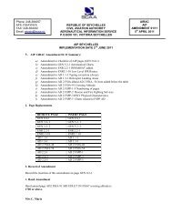
AIP AD 2 FSPP -1 SEYCHELLES 2 JUN 11 - SCAA
AIP AD 2 FSPP -1 SEYCHELLES 2 JUN 11 - SCAA
AIP AD 2 FSPP -1 SEYCHELLES 2 JUN 11 - SCAA

You also want an ePaper? Increase the reach of your titles
YUMPU automatically turns print PDFs into web optimized ePapers that Google loves.
<strong>AIP</strong> <strong>AD</strong> 2 <strong>FSPP</strong> -1<br />
<strong>SEYCHELLES</strong> 2 <strong>JUN</strong> <strong>11</strong><br />
_____________________________________________________________________________________________<br />
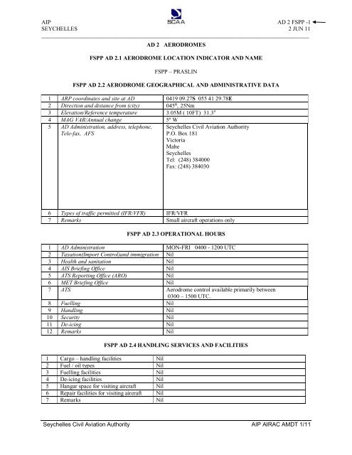
<strong>AD</strong> 2 AERODROMES<br />
<strong>FSPP</strong> <strong>AD</strong> 2.1 AERODROME LOCATION INDICATOR AND NAME<br />
<strong>FSPP</strong> – PRASLIN<br />
<strong>FSPP</strong> <strong>AD</strong> 2.2 AERODROME GEOGRAPHICAL AND <strong>AD</strong>MINISTRATIVE DATA<br />
1 ARP coordinates and site at <strong>AD</strong> 0419 09.27S 055 41 29.78E<br />
2 Direction and distance from (city) 045º, 25Nm<br />
3 Elevation/Reference temperature 3.05M ( 10FT) 31.3°<br />
4 MAG VAR/Annual change 5º W<br />
5 <strong>AD</strong> Administration, address, telephone,<br />
Tele-fax, AFS<br />
Seychelles Civil Aviation Authority<br />
P.O. Box 181<br />
Victoria<br />
Mahe<br />
Seychelles<br />
Tel: (248) 384000<br />
Fax: (248) 384030<br />
6 Types of traffic permitted (IFR/VFR) IFR/VFR<br />
7 Remarks Small aircraft operations only<br />
<strong>FSPP</strong> <strong>AD</strong> 2.3 OPERATIONAL HOURS<br />
1 <strong>AD</strong> Administration MON-FRI 0400 - 1200 UTC<br />
2 Taxation(Import Control)and immigration Nil<br />
3 Health and sanitation Nil<br />
4 AIS Briefing Office Nil<br />
5 ATS Reporting Office (ARO) Nil<br />
6 MET Briefing Office Nil<br />
7 ATS Aerodrome control available primarily between<br />
0300 – 1500 UTC.<br />
8 Fuelling Nil<br />
9 Handling Nil<br />
10 Security Nil<br />
<strong>11</strong> De-icing Nil<br />
12 Remarks Nil<br />
<strong>FSPP</strong> <strong>AD</strong> 2.4 HANDLING SERVICES AND FACILITIES<br />
1 Cargo – handling facilities Nil<br />
2 Fuel / oil types Nil<br />
3 Fuelling facilities Nil<br />
4 De-icing facilities Nil<br />
5 Hangar space for visiting aircraft Nil<br />
6 Repair facilities for visiting aircraft Nil<br />
7 Remarks Nil<br />
Seychelles Civil Aviation Authority <strong>AIP</strong> AIRAC AMDT 1/<strong>11</strong>
<strong>AIP</strong> <strong>AD</strong> 2 <strong>FSPP</strong> -2<br />
<strong>SEYCHELLES</strong> 2 <strong>JUN</strong> <strong>11</strong><br />
_____________________________________________________________________________________________<br />
<strong>FSPP</strong> <strong>AD</strong> 2.5 PASSENGER FACILITIES<br />
1 Hotels None available at Praslin aerodrome<br />
2 Restaurants Available at airport and in neighbouring hotels and<br />
guesthouses<br />
3 Transportation Taxis, car hires and buses<br />
4 Medical facilities Clinic at Grand Anse, located 2.5 km from the aerodrome<br />
5 Bank and Post Office Available at Grand Anse, 2.5 km from the aerodrome<br />
6 Tourist Office Tourist information desk only<br />
7 Remarks Nil<br />
<strong>FSPP</strong> <strong>AD</strong> 2.6 RESCUE AND FIRE FIGHTING SERVICES<br />
1 <strong>AD</strong> category for fire fighting CAT 5<br />
2 Rescue equipment 3 x Rescue & Fire Fighting vehicles totaling 7,500litres of<br />
water 1050 litres of foam 150 kg of DCP and 45kg of CO2<br />
Forcing and breaking equipment available<br />
Rescue boat with life raft (1 x65 men)<br />
I x ambulance provided<br />
2 Complete sets of Diving Equipment available<br />
3 Capacity for removal of disabled aircraft Local arrangement<br />
4 Remarks Service provided 24 hours<br />
<strong>FSPP</strong> <strong>AD</strong> 2.7 SEASONAL AVAILABILITY - CLEARING<br />
1 Types of clearing equipment Nil<br />
2 Clearing priorities Nil<br />
3 Remarks Nil<br />
<strong>FSPP</strong> <strong>AD</strong> 2.8 APRONS, TAXIWAYS AND CHECK LOCATIONS DATA<br />
1 Apron surface and strength Surface: Concrete<br />
Strength: Not determined<br />
2 Taxiway width, surface and strength Width: 8m<br />
Surface: Concrete<br />
Strength: Not determined<br />
3 ACL location and elevation Location: Nil<br />
Elévation: 3.05m / 10ft<br />
4 VOR/INS checkpoints Nil<br />
5 Remarks Aircraft heavier than a Shorts 360 are subject to approval<br />
from <strong>SCAA</strong>, depending on the frequency of flights.<br />
<strong>FSPP</strong> <strong>AD</strong> 2.9 SURFACE MOVEMENT GUIDANCE AND<br />
CONTROL SYSTEM AND MARKINGS<br />
1 Use of aircraft stand ID signs, TWY Nil<br />
guidelines and visual docking/parking<br />
guidance system of aircraft stands<br />
2 RWY and TWY markings and LGT RWY: Designation, THR, centre line, runway edge and end.<br />
Marked and lighted.<br />
TWY: Centre line holding positions at all TWY/RWY<br />
intersection. Marked and lighted.<br />
3 Stop bars Marked and lighted. Wing bars lighted.<br />
4 Remarks Blue Apron edge lights<br />
Seychelles Civil Aviation Authority <strong>AIP</strong> AIRAC AMDT 1/<strong>11</strong>
<strong>AIP</strong> <strong>AD</strong> 2 <strong>FSPP</strong> -3<br />
<strong>SEYCHELLES</strong> 2 <strong>JUN</strong> <strong>11</strong><br />
_____________________________________________________________________________________________<br />
<strong>FSPP</strong> <strong>AD</strong> 2.10 AERODROME OBSTACLES<br />
In approach/TKOF areas In circling area and at <strong>AD</strong> Remarks<br />
1 2<br />
RWY/AREA affected Obstacle type<br />
Elevation<br />
Markings/Lgt<br />
Coordinates Obstacle type<br />
Elevation<br />
Markings/ Lgt<br />
15 APCH<br />
33 TKOF<br />
15 APCH<br />
33 TKOF<br />
15 APCH<br />
33 TKOF<br />
a b c a<br />
Mountain Peak 04 18 14S<br />
40m /131ft 055 40 58E<br />
LGTD<br />
Mountain Peak<br />
<strong>11</strong>0m /361 ft<br />
LGTD<br />
Mountain Peak<br />
180m /591 ft<br />
LGTD<br />
33 APCH Mountain Peak<br />
260m /853ft<br />
LGTD<br />
04 17 43S<br />
055 40 52E<br />
04 17 53S<br />
055 41 19E<br />
04 20 16S<br />
055 43 37E<br />
Nil<br />
Nil<br />
Nil<br />
Nil<br />
Nil<br />
Designations<br />
RWY Number<br />
<strong>FSPP</strong> <strong>AD</strong> 2.<strong>11</strong> METEOROLOGICAL INFORMATION PROVIDED<br />
TRUE &MAG<br />
BRG<br />
- Nil -<br />
<strong>FSPP</strong> <strong>AD</strong> 2.12 RUNWAY PHYSICAL CHARACTERISTICS<br />
Dimensions of<br />
RWY (M)<br />
Strength (PCN)<br />
and surface of<br />
RWY and SWY<br />
THR<br />
coordinates<br />
THR elevation and<br />
highest elevation of<br />
TDZ of precision APP<br />
RWY<br />
1 2 3 4 5 6<br />
15 149 ˚ GEO 1405 X 30 Concrete 04 18 55.40S THR 3.05m /10 ft<br />
154 ˚ MAG<br />
055 41 21.49E<br />
33 329 ˚ GEO 1405 X 30 Concrete 04 19 26.65S THR 3.05m /10ft<br />
334 ˚ MAG<br />
055 41 40.17E<br />
Slope of RWY SWY CWY dimension Strip dimensions OFZ Remarks<br />
– SWY dimensions<br />
Nil Nil Nil 1490m x 150m 90m Nil<br />
Nil 222m Nil 1490m x 150m 90m Turning area available<br />
at the end of RWY 33<br />
<strong>FSPP</strong> <strong>AD</strong> 2.13 DECLARED DISTANCES<br />
RWY Designators TORA<br />
TODA<br />
ASDA<br />
LDA Remarks<br />
(M)<br />
(M)<br />
(M)<br />
(M)<br />
1 2 3 4 5 6<br />
15<br />
33<br />
1316<br />
1094<br />
1316<br />
1316<br />
Nil<br />
Nil<br />
1316<br />
1094<br />
(5.24%)<br />
Supplementary take-off distance for runway 33: 574m (3.3%) 765m (5.0%)<br />
<strong>11</strong>10<br />
1238<br />
(5.2°)<br />
Seychelles Civil Aviation Authority <strong>AIP</strong> AIRAC AMDT 1/<strong>11</strong>
<strong>AIP</strong> <strong>AD</strong> 2 <strong>FSPP</strong> -4<br />
<strong>SEYCHELLES</strong> 2 <strong>JUN</strong> <strong>11</strong><br />
_____________________________________________________________________________________________<br />
RWY<br />
Desig<br />
APCH<br />
LGT<br />
type<br />
LEN<br />
INSTS<br />
THR LGT<br />
colour<br />
WBAR<br />
<strong>FSPP</strong> <strong>AD</strong> 2.14 APPROACH AND RUNWAY LIGHTING<br />
VASIS<br />
(MEHT)<br />
PAPI<br />
TDZ<br />
LGT<br />
LEN<br />
RWY Ctr<br />
line LGT<br />
Length,<br />
spacing,<br />
colour ,<br />
INST<br />
RWY<br />
edge<br />
LGT<br />
LEN,<br />
spacing<br />
colour<br />
INST<br />
RWY End<br />
LGT<br />
colour<br />
WBAR<br />
SWY<br />
LGT<br />
LEN<br />
(M)<br />
colour<br />
1 2 3 4 5 6 7 8 9 10<br />
15 SALS Green PAPI Nil Nil 1217 White Nil *<br />
60m LIL<br />
4.5˚<br />
50m LIH<br />
33 SALS<br />
60m<br />
LIL<br />
Green PAPI<br />
3.5˚<br />
Nil Nil 1217<br />
50m LIH<br />
White Nil **<br />
* RWY 15 - Glide Slope Angle 4.5 ˚<br />
** RWY 33 - Glide Slope Angle 3.5˚<br />
Rem<br />
arks<br />
<strong>FSPP</strong> <strong>AD</strong> 2.15 OTHER LIGHTING, SECONDARY POWER SUPPLY<br />
1 ABN/IBN location, characteristics and hours of operation Nil<br />
2 LDI location and LGT Anemometer location and LGT LDI: Nil<br />
Anemometer :75m south-east of<br />
the Tower. Not lighted<br />
3 TWY edge and centre line lighting Edge: Blue LIH<br />
Centre line: Nil<br />
4 Secondary power supply /switch-over time Emergency lights: gooseneck<br />
flares available within 15 mins.<br />
Full standby power available with<br />
immediate changeover time.<br />
<strong>FSPP</strong> <strong>AD</strong> 2.16 HELICOPTER LANDING AREA<br />
Nil specifically designated<br />
<strong>FSPP</strong> <strong>AD</strong> 2.1 ATS AIRSPACE<br />
1 Designation and lateral limits Aerodrome traffic zone within<br />
1.5nm of aerodrome boundary.<br />
2 Vertical limits GND/MSL to 2 000ft MSL<br />
3 Airspace classification D<br />
4 ATS unit call sign Language (s) Praslin Tower (English)<br />
5 Transition altitude 4200ft QNH<br />
6 Minimum safe altitude 2500ft QNH<br />
<strong>FSPP</strong> <strong>AD</strong> 2.18 ATS COMMUNICATION FACILITIES<br />
Service designation Call sign Frequency Hours of operation Remarks<br />
1 2 3 4 5<br />
TWR Praslin Tower 122.30 MHZ HJ & HO btn 1500-0300 UTC Nil<br />
SMC Praslin Tower 121.80MHZ HJ & HO btn 1500-0300 UTC Nil<br />
Seychelles Civil Aviation Authority <strong>AIP</strong> AIRAC AMDT 1/<strong>11</strong>
<strong>AIP</strong> <strong>AD</strong> 2 <strong>FSPP</strong> -5<br />
<strong>SEYCHELLES</strong> 2 <strong>JUN</strong> <strong>11</strong><br />
_____________________________________________________________________________________________<br />
Type of aid,<br />
CAT of<br />
ILS/MLS (for<br />
VOR/ILS/MLS,<br />
give VAR)<br />
<strong>FSPP</strong> <strong>AD</strong> 2.19 R<strong>AD</strong>IO NAVIGATION AND LANDING AIDS<br />
ID Frequency Hours of<br />
operation<br />
Site of<br />
transmitting<br />
antenna<br />
coordinates<br />
Elevation of<br />
DME<br />
transmitting<br />
antenna<br />
1 2 3 4 5 6 7<br />
DVOR PRA <strong>11</strong>5.70MHZ H24 04 18 26.52 S 337<br />
Nil<br />
055 42 25.49 E AMSL<br />
DME PRA CH104X H24 04 18 26.39S<br />
055 42 25.40E<br />
337<br />
AMSL<br />
Nil<br />
Remarks<br />
Remarks: Maintenance period are as follows: PRA DVOR/DME 3 rd Tuesday of every month btn 0400-0800 UTC<br />
<strong>FSPP</strong> <strong>AD</strong> 2.20 LOCAL TRAFFIC REGULATIONS<br />
- Nil -<br />
<strong>FSPP</strong> <strong>AD</strong> 2.21 NOISE ABATEMENT<br />
PROCEDURES<br />
- Nil -<br />
<strong>FSPP</strong> <strong>AD</strong> 2.22 FLIGHT PROCEDURES<br />
2.22.1 Radio Communication failure – Praslin<br />
aerodrome<br />
a) Where contact has not been established with<br />
Seychelles Approach after departure from<br />
Praslin, continue to destination aerodrome,<br />
maintaining VMC and follow procedures as laid<br />
down on page <strong>AD</strong> 2.1-10, para. 2.22.3, Radio<br />
Communications Procedures.<br />
b) Where contact has not been established with<br />
Praslin Tower (arriving aircraft), continue to<br />
Praslin aerodrome maintaining VMC. Proceed<br />
overhead the PRA DVOR, not below 2 500ft<br />
QNH, maintaining a vigilant look out for other<br />
inbound traffic. From overhead join the traffic<br />
pattern by making a downwind leg and land if<br />
possible within 15 minutes of the last<br />
acknowledged estimated time of arrival.<br />
c) Where contact has previously been established<br />
with Praslin Tower (arriving aircraft) and where<br />
an aircraft had initially been cleared to a visual<br />
holding point prior to landing, it shall leave such<br />
visual holding point at the last acknowledged<br />
expected onward clearance time and comply<br />
with 1(a) and 1(b) above and land within 30<br />
minutes. If no onward clearance time had been<br />
given, hold at the visual holding point for at least<br />
10 minutes before commencing the approach.<br />
d) In the event where an inbound traffic to Praslin<br />
cannot land due to poor visibility, it shall:<br />
e) In the event where an inbound traffic to Praslin<br />
cannot land due to poor visibility, it shall:<br />
• proceed to nearest suitable aerodrome and<br />
land, and<br />
• contact Seychelles Approach Control as<br />
soon as possible.<br />
<strong>FSPP</strong> <strong>AD</strong> 2.23 <strong>AD</strong>DITIONAL INFORMATION<br />
<strong>FSPP</strong> <strong>AD</strong> 2.24<br />
- Nil -<br />
CHARTS RELATED TO<br />
PRASLIN AERODROME<br />
• Aerodrome Chart-ICAO<br />
• Instrument Approach Chart- ICAO<br />
VOR a (CAT A-B)<br />
• Instrument Approach Chart- ICAO<br />
VOR b (CAT C)<br />
• Instrument Approach Chart-ICAO<br />
VOR c (CAT A-B)<br />
Seychelles Civil Aviation Authority <strong>AIP</strong> AIRAC AMDT 1/<strong>11</strong>