Gelderse Poort - ARK Natuurontwikkeling
Gelderse Poort - ARK Natuurontwikkeling
Gelderse Poort - ARK Natuurontwikkeling

You also want an ePaper? Increase the reach of your titles
YUMPU automatically turns print PDFs into web optimized ePapers that Google loves.
<strong>Gelderse</strong><br />
<strong>Poort</strong><br />
A WWF One Europe,<br />
More Nature Pilot Project Site<br />
WWF “One Europe, More Nature (OEMN)” has<br />
supported an innovative pilot project at the <strong>Gelderse</strong><br />
<strong>Poort</strong> in the Rhine River delta of the Netherlands. Its<br />
goal is to improve nature conservation and flood protection<br />
while enhancing nature-based businesses and<br />
alternative incomes for locals.<br />
Overall, local people are successfully building a new<br />
economy, creating new jobs and restoring ecological<br />
processes and landscape quality. The whole process<br />
takes place on a voluntary basis and is market-driven<br />
and independent of long-term subsidies. New partnerships<br />
were established between WWF, other NGOs,<br />
brick companies, farmers, governmental authorities<br />
and private businesses and entrepreneurs. Initiated by<br />
WWF-Netherlands and <strong>ARK</strong> (a local NGO) in the<br />
1990s, the approach, lessons and success of the <strong>Gelderse</strong><br />
<strong>Poort</strong> project led to the development of WWF’s One<br />
Europe More Nature programme. Since 2003, the<br />
<strong>Gelderse</strong> <strong>Poort</strong> project has acted as a living demonstration<br />
of how business and nature can go hand-in-hand,<br />
how innovative approaches can lead to benefits for<br />
people and nature, and how new economies can be built<br />
around conservation. In this way, it continues to inspire<br />
and encourage the OEMN staff in other projects around<br />
the continent.
About the<br />
Project Area<br />
Problems<br />
Solutions and<br />
Results<br />
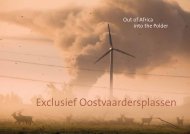
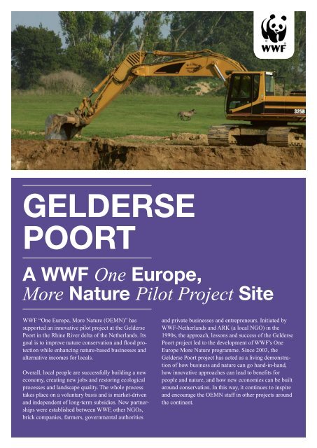
3. Sand extraction for new landscapes<br />
In 2003, the sand and gravel industry launched a new vision on<br />
mining supported by environmental organisations. Similar to<br />
Living Rivers, extraction would be used to build new landscapes in<br />
which ecological processes are restored and social needs fulfilled<br />
(e.g. water retention, leisure areas). Pilot projects are now underway.<br />
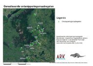
Location<br />
The project is located where the Rhine River branches out into the<br />
rivers Waal, Lower Rhine and IJssel, at the top of the Rhine River<br />
delta on the Dutch / German border. It covers some 1,500 ha.<br />
Significant landscapes, habitats and species<br />
A century ago the area’s floodplains used to be full of natural<br />
marshes with plenty of biodiversity and small nature reserves. The<br />
landscape was dominated by grasslands with rich communities of<br />
meadow birds such as corncrakes, ruff, black-tailed godwit,<br />
skylark and meadow pipit.<br />
Later on, farmers drained the marshy fields to create new cultivated<br />
fields, resulting in some biodiversity decreases. After 1950,<br />
agricultural intensification, and resultant losses in biodiversity,<br />
increased. However, elsewhere in the Netherlands, the destruction<br />
of the landscape was even worse.<br />
Human presence<br />
Nearby, the cities of Arnhem, Nijmegen and Emmerich are today<br />
inhabited by about half a million people. Within <strong>Gelderse</strong> <strong>Poort</strong>,<br />
there are 15 villages with a total population of about 25,000.<br />
Economic status<br />
Agriculture: Initially, farming was concentrated on higher lands.<br />
Then in the 13th century, when alluvial forests were removed and<br />
dikes constructed, the river forelands were also occupied. Here, a<br />
thick clay layer had formed after centuries of floods and sedimentation<br />
which was good for agriculture. Farming focused on cattle<br />
breeding and the cultivation of sugar beet, potatoes, maize, wheat<br />
and fruit.<br />
After World War II, Ooijpolder developed from a small-scale<br />
agricultural mosaic into industrialised farmland, with the average<br />
annual milk production per cow increasing from 5,000 kg (1980)<br />
to 11,000 kg (2004). The new agriculture was characterised by<br />
large fields, high fertiliser volumes, low groundwater levels and<br />
high yields. In the 1950s, nearly 1,000 small farmers earned a<br />
living in an area where today only 50 farms remain.<br />
Clay mining and brick making: One of the oldest industries in the<br />
region, brick factories used to buy land parcels from farmers,<br />
excavate the top layer of alluvial clay (for brick making) and either<br />
leave behind a clay-pit or re-cultivate the area to return it to<br />
agricultural use.<br />
Sand extraction: Thick layers of fluvial sands in the subsoil made<br />
the area suitable for sand extraction – traditionally used as material<br />
for building sites and infrastructure projects such as roads and<br />
railways.<br />
Clay mining and brick making: Around 1980, the river forelands<br />
on which the clay mining industry depended became increasingly<br />
renowned for their nature values. As a consequence, conservationists<br />
opposed new clay mining activities and threatened the future<br />
of the brick industry.<br />
Sand extraction: Recently, national and regional authorities placed<br />
heavy restrictions on sand extraction because of its environmental<br />
impact and lack of public support for large pits in the landscape.<br />
In fact, deep sand and gravel extraction in the river forelands has<br />
been illegal for 15 years.<br />
Tourism and recreation: For the public, the area was either<br />
unknown or had a poor reputation: the rivers were polluted and<br />
nature reserves were fenced off to visitors. The few hotels and<br />
cafés in the area were barely able to break even financially.<br />
Floods: Flood protection has always been an important issue.<br />
Dikes were constructed in the Middle Ages. Exceptionally high<br />
floods occurred in 1993 and 1995. In 1995, hundreds of thousands<br />
of people and livestock were evacuated. This was a shattering<br />
experience for the Dutch since the country had a sacred faith in<br />
dykes. This near-disaster heightened the public’s awareness that<br />
floodplain capacity cannot be diminished further without risking<br />
severe floods and losses of life and goods. Moreover, climate<br />
change and sea level rises in the future also threaten larger floods.<br />
WWF’s main goal is to improve nature conservation and flood<br />
protection while enhancing nature-based businesses and alternative<br />
incomes for locals.<br />
The mechanisms used by WWF to reach this goal include:<br />
(1) digging clay for bricks and wetlands; (2) promoting natural<br />
processes and grazing; (3) sand extraction for new landscapes;<br />
(4) supporting eco-tourism, recreation and mixed farming;<br />
and (5) increasing flood retention capacity.<br />
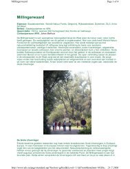
1. Digging clay for bricks and wetlands<br />
In 1992, WWF-Netherlands’ Living Rivers concept elaborated on<br />
Plan Ooievaar’s suggestions by adding a water retention philosophy<br />
and a new economic driver – clay mining. Earlier, it had been<br />
observed that new clay pits could host biodiversity. This would<br />
partly substitute the declining role of agriculture and contribute to<br />
the ecological restoration of the riverine landscape and flood<br />
prevention. The Millingerwaard, a 600 ha area on the river<br />
foreland, became the pilot area to test new ideas and new partnerships<br />
between the State Forestry Service, private brick-making<br />
companies, WWF-Netherlands and local NGO “<strong>ARK</strong>”.<br />
Digging gave brick companies a fresh source of clay for their<br />
bricks, and a better image – “Building with bricks is building for<br />
nature”. During the digging, the landscape was lowered by several<br />
metres, allowing for a new landscape of floodplains, wetlands and<br />
grasslands. Former elements such as old river beds, islands and<br />
lost animals and plants also returned. Today, waterfowl abound in<br />
the new man-made marshes in the floodplains which also serve as<br />
nursing grounds for spawning fish.<br />
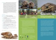
2. Promoting natural processes and grazing<br />
The project found that the best formula for restoring the characteristic<br />
flora and fauna of the riverine system is through the<br />
promotion of a regime of natural processes such as flooding,<br />
erosion, sedimentation and natural grazing in the floodplain.<br />
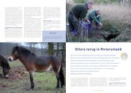
Natural grazing in restored natural areas in the river forelands<br />
started in the Millingerwaard in the early 1990s as a modest<br />
experiment on 5 ha of river dunes with a few Konik horses and<br />
Galloway cattle. Today, hundreds of hectares along the 15 km long<br />
riverbank are involved and hundreds of cattle and horses roam the<br />
foreland wilderness. Surveillance work is delegated to local<br />
experts (e.g. enthusiastic farmers) and the project is almost<br />
self-supporting economically. Income is generated by the natural<br />
growth of the herds. Part of the surplus is destined for the<br />
production and sale of “wilderness meat” marketed by <strong>ARK</strong><br />
through its internet, local contacts, a “Wilderniscafé” and<br />
newsletter. Another part of the surplus is sold as livestock to<br />
natural grazing projects elsewhere in the Netherlands and abroad.<br />
4. Supporting eco-tourism, recreation and mixed farming<br />
Since 1992, the booming natural and “wild” qualities of the area,<br />
along with successful communications campaigns, have triggered<br />
new economic opportunities. Hundreds of thousands of people<br />
now visit the area annually. Restaurants, hotels and cafés have<br />
revived and new ones have sprung up, resulting in a substantial<br />
growth of jobs in tourism and recreation. The river and its<br />
landscape are big business! Infrastructure and bus services also<br />
improved.<br />
Promoting the area name “<strong>Gelderse</strong> <strong>Poort</strong>” as a brand contributed<br />
enormously. Most if not all of the facilities use the landscape<br />
quality of the <strong>Gelderse</strong> <strong>Poort</strong> in their marketing strategy. At the<br />
entrance of the Millingerwaard reserve, the Wilderniscafé provides<br />
visitors with nature information, guided tours, festivities and food<br />
and drinks sourced largely from the region.<br />
In 2004, a new “mixed farming” pilot began with local farmers to<br />
integrate food production, nature restoration and tourism. One task<br />
was to develop migration corridors for flora and fauna between<br />
agricultural fields – a web of green landscape lines such as broad<br />
hedges along ditches or strips with natural vegetation. Landowners<br />
would manage the new landscape elements, as well as extensive<br />
grazing and new public footpaths. Farmers were initially compensated<br />
for their “green services” through a “landscape auction” in<br />
September 2007 when dozens of companies and individuals donated<br />
a total of 120,000 Euros, enabling a 10-year contract of the project.<br />
5. Increasing flood retention capacity<br />
The new method of clay excavation suggested by Living Rivers<br />
produced millions of cubic metres of extra flood retention capacity.<br />
Several summer dikes were removed, sediment layers were peeled<br />
off and new side channels were constructed. It is estimated that<br />
this created 1,500 ha of natural riverine habitat.<br />
Project Magnification<br />
The project area is now increasingly considered the “green lung”<br />
of an expanding urbanized and economically important region.<br />
The pilot areas were important to show politicians, decisionmakers<br />
and others how clay mining and other solutions enhanced<br />
the powers of nature – when it is given more space, nature returns.<br />
One economic driver and/or pilot project is enough to provoke a<br />
chain reaction resulting in more economic partners joining in and /<br />
or starting other projects.<br />
Since 1992, experiences in the <strong>Gelderse</strong> <strong>Poort</strong> have been rapidly<br />
followed by some 50 similar projects in other areas started along<br />
the lines of the first pilot, with authorities and private entrepreneurs<br />
having discovered the opportunities for working toward<br />
building a new nature-based economy.
OEMN Mission<br />
WWF’s One Europe More Nature (OEMN) project uses an innovative<br />
approach to forge unusual partnerships so that business and<br />
nature can co-exist. Its mechanisms lead to win-win solutions for<br />
all, allowing Europe’s rural workers to make incomes from the<br />
countryside while protecting nature. OEMN, tested at many pilot<br />
rural locations throughout Europe, is now mainstreaming conservation<br />
into everyday European business life.<br />
Other WWF OEMN pilot project sites<br />
Väinameri (Estonia), Maramures (Romania), Tisza (Hungary),<br />
Sinca Noua (Romania), Doñana (Spain), Merja Zerga (Morocco),<br />
Prespa (Greece, Albania, Former Yugoslav Republic of Macedonia)<br />
Contacts<br />
About WWF OEMN<br />
Charlie Avis<br />
Project Leader<br />
charlie.avis@wwf.hu<br />
Mob.: +36 30 414 44 54<br />
About <strong>ARK</strong><br />
Johan Bekhuis<br />
<strong>ARK</strong> <strong>Natuurontwikkeling</strong><br />
p/a Weth. Sandersstraat 10<br />
6579 AK Kekerdom<br />
Mob.: +31 651 79 08 35<br />
johan.bekhuis@xs4all.nl<br />
www.ark.eu<br />
About WWF in the Netherlands<br />
Arjan Berkhuysen<br />
WWF-Netherlands<br />
Driebergseweg 10<br />
3708 JB Zeist<br />
The Netherlands<br />
Tel.: +31 306 93 73 33<br />
aberkhuysen@wwf.nl<br />
More information about<br />
WWF OEMN on the internet:<br />
www.panda.org/europe/oemn<br />
Photo credits<br />
Toomas Kokovkin, Bart Beekers<br />
De <strong>Gelderse</strong> <strong>Poort</strong><br />
(Netherlands)