Next steps The work needs to be refined in some areas, based on more precise criteria and information. The fire regime classification should be improved and high resolution satellite images (such as Landsat ETM+) used for the entire territory, supported by adequate ground verification. Conservation values within intact forest landscapes should be mapped and described illustrated so that well-informed and balanced decisions can be made without delay about conservation and use. Conservation values must also be mapped outside <strong>of</strong> the intact forest landscapes, i.e. in the production landscape. Mapping must become more detailed and incorporate the kvartal grid <strong>of</strong> Russian forestry. A retrospective study would add knowledge on the global carbon cycle and form a reference for monitoring future changes. Areas considered as immediate priority for refined mapping <strong>of</strong> conservation values include the Ural Mountains and Southern taiga belt in European Russia (the Leningrad, Vologda, Kostroma, Kirov and Perm Oblasts), the Altay-Sayan area in Western Siberia, the Angara-Enisey and Baikal Lake areas in Eastern Siberia, and the Sikhote-Alin Range in the Russian Far East. Purpose This atlas presents an inventory <strong>of</strong> intact forest landscapes (i.e. the remaining large, unbroken areas <strong>of</strong> pristine nature within the forest zone <strong>of</strong> Russia). This endeavor was carried out by a group <strong>of</strong> Russian nongovernmental conservation and scientific organizations between 1999 and 2002 as part <strong>of</strong> the Global <strong>Forest</strong> Watch initiative. The purpose <strong>of</strong> the atlas is to provide an accurate picture <strong>of</strong> remaining intact forest landscapes in Russia, and the boundaries <strong>of</strong> federally protected areas, to allow decisions about these landscapes to become better informed and more balanced. In particular, the results are crucial to implementation <strong>of</strong> Article 4 (On Environmental Protection) <strong>of</strong> the Law <strong>of</strong> the Russian Federation, which states that “priority objects for conservation are natural ecosystems, natural landscapes and natural associations, unaffected by anthropogenic influences (un<strong>of</strong>ficial translation).” The atlas will also support the forest industry’s effort to exercise precaution in sourcing wood from specific, ecologically sensitive areas. Definitions and criteria An intact forest landscape is a landscape in the forest zone that is whole and natural, undivided by infrastructure and almost entirely unaffected by human activities. It is large enough to support viable populations <strong>of</strong> large predatory vertebrates and keep most <strong>of</strong> the territory free <strong>of</strong> edge effects (minimum 50 thousand hectares). It may, and typically does, contain a mosaic <strong>of</strong> ecosystems (i.e. it is more than a forest). It has a natural fire regime. Method A three-step procedure was used to exclude non-intact areas and delineate remaining intact landscapes: Areas around human settlements and infrastructure were excluded along with residual fragments smaller than 50,000 ha, based on a 1:500,000 scale topographic map <strong>of</strong> Russia. Further exclusion <strong>of</strong> non-intact areas and residual fragments smaller than 50,000 ha, based on medium resolution satellite images (a country-wide mosaic <strong>of</strong> Resurs MSU-SK with 150 m resolution from the summer and winter seasons, and Landsat ETM+ Quicklooks with 300 m resolution). Most agricultural areas and clearcuts <strong>of</strong> various ages were excluded at this stage. Further exclusion <strong>of</strong> non-intact areas and residual fragments smaller than 50,000 ha, followed by fine tuning <strong>of</strong> boundaries, based on high-resolution satellite images (Landsat ETM+ with a resolution <strong>of</strong> 30 meters, ASTER with a resolution <strong>of</strong> 15 meters, and Resurs MSU-E with a resolution <strong>of</strong> 35 meters. Satellite images from 1999 to 2001 were used and reflect the status <strong>of</strong> the landscape at the middle <strong>of</strong> year 2000. All satellite images were geo-referenced onto the 1:500,000 or finer scale topographical map. <strong>Forest</strong> inventory maps at various scales at the level <strong>of</strong> leskhoz (local <strong>of</strong>fice <strong>of</strong> the state forest management agency), other thematic maps and field data on the degree <strong>of</strong> disturbance were used at all stages <strong>of</strong> the analysis. In total, approximately 9000 Landsat ETM+ Quicklooks, 5000 ASTER, 200 Resurs MSU-E, 800 Resurs MSU-SK and 350 Landsat ETM+ scenes were used. 6 <strong>Atlas</strong> <strong>of</strong> Russia’s <strong>Intact</strong> <strong>Forest</strong> <strong>Landscapes</strong>
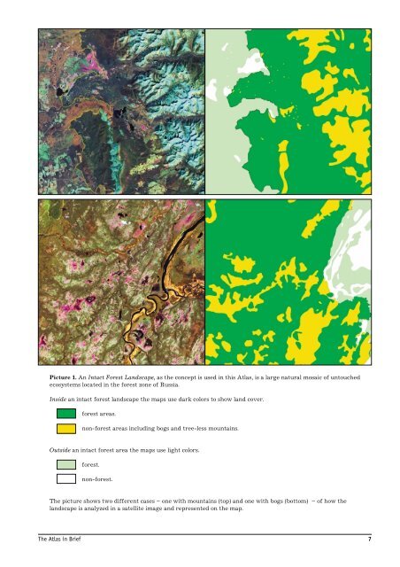
Picture 1. An <strong>Intact</strong> <strong>Forest</strong> Landscape, as the concept is used in this <strong>Atlas</strong>, is a large natural mosaic <strong>of</strong> untouched ecosystems located in the forest zone <strong>of</strong> Russia. Inside an intact forest landscape the maps use dark colors to show land cover. forest areas. non-forest areas including bogs and tree-less mountains. Outside an intact forest area the maps use light colors. forest. non-forest. The picture shows two different cases – one with mountains (top) and one with bogs (bottom) – <strong>of</strong> how the landscape is analyzed in a satellite image and represented on the map. The <strong>Atlas</strong> in Brief 7