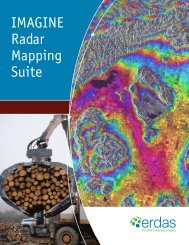
Leica Photogrammetry Suite Productivity Accuracy Deep Functionality
Leica Photogrammetry Suite Productivity Accuracy Deep Functionality
Leica Photogrammetry Suite Productivity Accuracy Deep Functionality

You also want an ePaper? Increase the reach of your titles
YUMPU automatically turns print PDFs into web optimized ePapers that Google loves.
<strong>Leica</strong> <strong>Photogrammetry</strong> <strong>Suite</strong><br />
<strong>Productivity</strong><br />
<strong>Accuracy</strong><br />
<strong>Deep</strong> <strong>Functionality</strong>
This image of Walensee, Switzerland, was taken with the<br />
<strong>Leica</strong> ADS40 Airborne Digital Sensor.<br />
Experts in photogrammetry and production mapping today are pushed harder and<br />
harder to produce more in a shorter period of time — but not at the expense of<br />
accuracy. Most photogrammetric software, while offering in-depth functionality and<br />
adequate accuracy, can be complex and difficult to use, not to mention expensive.<br />
That affects production…<br />
A New Standard in <strong>Photogrammetry</strong><br />
The demand for geospatial information is increasing<br />
at a remarkable pace. People who are not geospatially<br />
oriented are beginning to understand the value geospatial<br />
information brings to everyday business needs. For<br />
those with photogrammetric needs, one might ask,<br />
how do you streamline projects into one fast, manageable<br />
workflow With this, is it possible to reach new levels of<br />
production throughput without compromising the detail<br />
and accuracy your customers expect or the functionality<br />
you’ve grown accustomed to You can do all of this and<br />
more with <strong>Leica</strong> <strong>Photogrammetry</strong> <strong>Suite</strong> (LPS) from <strong>Leica</strong><br />
Geosystems Geospatial Imaging. LPS — a new standard<br />
in photogrammetry — is a seamlessly integrated collection<br />
of software tools that lets you transform raw imagery<br />
into reliable data layers required for all digital mapping,<br />
GIS analysis and 3D visualization.<br />
With a rich history, <strong>Leica</strong> Geosystems continues to lead the<br />
industry with a growing portfolio of interoperable geospatial<br />
solutions in image exploitation, processing, visualization and<br />
data management. LPS empowers geospatial professionals<br />
to create precise data and put it to work.<br />
<strong>Productivity</strong> Taken to the Next Level<br />
In today’s I-want-it-yesterday environment, it’s no longer<br />
good enough to just produce accurate data. If your company<br />
is like most, additional resources are not an option. That’s<br />
why we put so much emphasis on designing LPS to make<br />
you as efficient as possible without compromising quality<br />
and accuracy.
Photogrammetric Workflow Workflow<br />
Input Imagery<br />
Radiometric Adjustment<br />
Project Setup<br />
Walensee DTM with a contour interval of 50m.<br />
Camera Definition<br />
Interior Orientation<br />
A process-driven workflow is the key to increased<br />
productivity, and a process-driven system that efficiently<br />
transforms imagery into reliable geospatial content is the<br />
engine that drives it. Features such as automatic interior<br />
orientation, automatic tie point measurement, automatic<br />
terrain extraction and intelligent multiple-image loading let<br />
you focus on using your expertise to fine-tune the data by<br />
taking many of the repetitive tasks off your hands.<br />
<strong>Leica</strong> <strong>Photogrammetry</strong> <strong>Suite</strong> helps you save time in other<br />
ways, too. The clean, intuitive interface makes it easy to<br />
learn and easy to use. The workflow driven toolbar guides<br />
the process, giving you everything you need to execute<br />
a photogrammetric project from beginning to end. Data<br />
interoperability is never an issue — data from other leading<br />
photogrammetric software may be used in LPS. You may<br />
even continue using PRO600 and ORIMA and, if necessary,<br />
replace your current software with the relevant LPS modules.<br />
In addition, you can streamline production workflow with the<br />
LPS process driven toolbar and Project Manager.<br />
LPS Architecture<br />
Aerial Triangulation<br />
Terrain Generation<br />
Edit Terrain<br />
Feature Extraction<br />
Orthophoto Generation & Mosaicking<br />
Better Solutions for a Better Price<br />
Superior technology doesn’t have to come with a higher<br />
price tag. <strong>Leica</strong> <strong>Photogrammetry</strong> <strong>Suite</strong> is affordable, while<br />
meeting all of your mapping needs.<br />
The modular design of LPS makes it scalable to<br />
accommodate a variety of photogrammetric processes.<br />
Add-on modules, productivity bundles and customizability<br />
let you tailor your system to your exact needs — you’ll never<br />
be forced to purchase a tool you won’t use.<br />
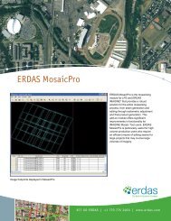
MosaicPro<br />
With LPS, even technical assistance and training services<br />
are affordable. We know you depend on your system to<br />
be in top working order, so the experienced, knowledgeable<br />
professionals at <strong>Leica</strong> Geosystems stand ready to assist<br />
you with everything from training and customized solutions<br />
to technical and on-site installation assistance.
This image of Burbank, California, was taken with the <strong>Leica</strong> RCD105 39-megapixel medium format digital camera.<br />
<strong>Accuracy</strong> You Can Depend On<br />
We know how important accuracy is in the photogrammetry<br />
industry. Because of this, LPS uses state-of-the-art<br />
photogrammetric and image-processing technology<br />
to fine-tune your data and report results:<br />
Automatic point measurement and terrain extraction<br />
Subpixel stereo display and point positioning<br />
Proven and accepted triangulation<br />
Rigorous sensor models<br />
Built-in data quality checks<br />
With LPS, accuracy is never in doubt.<br />
<strong>Leica</strong> <strong>Photogrammetry</strong> <strong>Suite</strong> Core<br />
LPS Core enables you to perform powerful yet simple<br />
orientation and orthorectification. The Core module<br />
provides all of the necessary tools required to<br />
transform raw imagery into reliable geospatial data.<br />
This comprehensive suite includes:<br />
ERDAS IMAGINE ® Advantage<br />
Image Viewer<br />
Image Imports and Exports<br />
Color Balancing<br />
Map Compositioning<br />
3D Surfacing<br />
Image Processing Tools<br />
Ortho-mosaicking<br />
Automatic Interior Orientation Triangulation<br />
Manual and Automatic Point Measurement<br />
LPS Project Manager
This image of downtown Los Angeles was taken with the <strong>Leica</strong> RCD105<br />
39-megapixel medium format digital camera.<br />
Add-On Modules<br />
LPS is scalable, so you can purchase only the tools<br />
you need to build your solution on top of the Core.<br />
The add-on modules provide additional productionoriented<br />
tools that help maximize data throughput.<br />
LPS Stereo brings you the power of extracting<br />
geospatial content in a stereo viewing environment.<br />
It features subpixel pointing, continuous roaming and<br />
zooming, as well as fast-graphics rendering. Viewing<br />
options include Stereo, Split Panel, Mono and Tri-View.<br />
LPS Terrain Editor (TE) includes point, area and linebased<br />
terrain editing needed to clean DTMs using<br />
stereo imagery as a reference backdrop. TE supports<br />
many DTM formats, including the <strong>Leica</strong> Terrain format,<br />
TerraModel TINs and raster DEMs.<br />
ORIMA Digital <strong>Photogrammetry</strong> (DP) for LPS is a<br />
modern, easy-to-use orientation management<br />
software that processes large datasets of image<br />
coordinates, ground control points and GPS<br />
coordinates. ORIMA lets you perform productionfocused<br />
aerial triangulation for analog and digital<br />
frame and <strong>Leica</strong> ADS40 imagery with outstanding<br />
diagnostic tools.<br />
PRO600 puts flexible, easy-to-learn CAD-based tools<br />
in your hands for large-scale digital mapping using<br />
stereo imagery, including signs, symbols, colors, line<br />
thickness, user-defined line-types and forms.<br />
Automatic Terrain Extraction (ATE) allows for fast,<br />
accurate automatic terrain extraction from multiple<br />
images using sophisticated techniques with built-in<br />
accuracy reporting.<br />
<strong>Leica</strong> MosaicPro features improved seam editing<br />
capabilities, enhanced functionality and improved<br />
radiometric adjustment abilities. With seam editing,<br />
image previewing and a streamlined user interface,<br />
<strong>Leica</strong> MosaicPro increases efficiency through a smooth<br />
process and improved functionality, which ultimately<br />
reduces project time.<br />
ImageEqualizer® corrects variations and flaws in<br />
imagery due to hot spots, vignetting, atmospheric<br />
effects and film processing in scanned aerial<br />
photography or unbalanced satellite images.<br />
Stereo Analyst for IMAGINE is feature extraction, 3D<br />
model generation, interpretation, measurement and<br />
visualization tool which uses stereo imagery to derive<br />
3D information.<br />
The New Standard -<br />
Just a Phone Call Away<br />
You can have it all with the new standard in<br />
photogrammetry — the <strong>Leica</strong> <strong>Photogrammetry</strong><br />
<strong>Suite</strong>, from the company geospatial professionals<br />
have trusted for generations. Take your<br />
photogrammetry technology to the next level<br />
today. Call +1 877 463 7327 or e-mail<br />
info@gi.leica-geosystems.com for more information.
About <strong>Leica</strong> Geosystems Geospatial Imaging<br />
To be successful in our changing marketplace, you need reliable,<br />
enterprise-enabled geospatial information. <strong>Leica</strong> Geosystems Geospatial<br />
Imaging transforms your raw data to useable information, integrating<br />
a broad range of geospatial technology throughout your enterprise,<br />
via web-based, mobile and desktop clients. Delivering the most<br />
comprehensive solutions in image exploitation, processing,<br />
visualization and data management, <strong>Leica</strong> Geosystems provides<br />
robust image compression techniques and the most efficient delivery<br />
of imagery over the Internet or within an organization. With Open<br />
Geospatial Consortium (OGC) and International Organization for<br />
Standardization (ISO) interoperability, <strong>Leica</strong> Geosystems develops<br />
solutions with the most advanced service-oriented platform available.<br />
Those who use <strong>Leica</strong> Geosystems products trust them for their<br />
precision, seamless integration, interoperability and superior customer<br />
support. Geospatial solutions from <strong>Leica</strong> Geosystems - when it has<br />
to be right.<br />
<strong>Leica</strong> Geosystems is part of the Hexagon Group, Sweden. For more<br />
information about <strong>Leica</strong> Geosystems or its products and services,<br />
please call +1 770 776 3400, toll free +1 866 534 2286, or visit<br />
www.gi.leica-geosystems.com.<br />
Copyright © 2008 <strong>Leica</strong> Geosystems Geospatial Imaging, LLC. Unpublished – All rights reserved.<br />
Use, reproduction or disclosure is governed solely by the <strong>Leica</strong> Geosystems Geospatial Imaging, LLC standard<br />
commercial license. Contractor/Manufacturer is <strong>Leica</strong> Geosystems Geospatial Imaging, LLC, 5051 Peachtree<br />
Corners Circle, <strong>Suite</strong> 100, Norcross, GA 30092-2500 USA.<br />
<strong>Leica</strong> Geosystems Geospatial Imaging, LLC<br />
5051 Peachtree Corners Circle, <strong>Suite</strong> 100<br />
Norcross, GA 30092-2500 USA<br />
Phone +1 770 776 3400<br />
gi.leica-geosystems.com