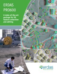
Leica Photogrammetry Suite Productivity Accuracy Deep Functionality
Leica Photogrammetry Suite Productivity Accuracy Deep Functionality
Leica Photogrammetry Suite Productivity Accuracy Deep Functionality

You also want an ePaper? Increase the reach of your titles
YUMPU automatically turns print PDFs into web optimized ePapers that Google loves.
About <strong>Leica</strong> Geosystems Geospatial Imaging<br />
To be successful in our changing marketplace, you need reliable,<br />
enterprise-enabled geospatial information. <strong>Leica</strong> Geosystems Geospatial<br />
Imaging transforms your raw data to useable information, integrating<br />
a broad range of geospatial technology throughout your enterprise,<br />
via web-based, mobile and desktop clients. Delivering the most<br />
comprehensive solutions in image exploitation, processing,<br />
visualization and data management, <strong>Leica</strong> Geosystems provides<br />
robust image compression techniques and the most efficient delivery<br />
of imagery over the Internet or within an organization. With Open<br />
Geospatial Consortium (OGC) and International Organization for<br />
Standardization (ISO) interoperability, <strong>Leica</strong> Geosystems develops<br />
solutions with the most advanced service-oriented platform available.<br />
Those who use <strong>Leica</strong> Geosystems products trust them for their<br />
precision, seamless integration, interoperability and superior customer<br />
support. Geospatial solutions from <strong>Leica</strong> Geosystems - when it has<br />
to be right.<br />
<strong>Leica</strong> Geosystems is part of the Hexagon Group, Sweden. For more<br />
information about <strong>Leica</strong> Geosystems or its products and services,<br />
please call +1 770 776 3400, toll free +1 866 534 2286, or visit<br />
www.gi.leica-geosystems.com.<br />
Copyright © 2008 <strong>Leica</strong> Geosystems Geospatial Imaging, LLC. Unpublished – All rights reserved.<br />
Use, reproduction or disclosure is governed solely by the <strong>Leica</strong> Geosystems Geospatial Imaging, LLC standard<br />
commercial license. Contractor/Manufacturer is <strong>Leica</strong> Geosystems Geospatial Imaging, LLC, 5051 Peachtree<br />
Corners Circle, <strong>Suite</strong> 100, Norcross, GA 30092-2500 USA.<br />
<strong>Leica</strong> Geosystems Geospatial Imaging, LLC<br />
5051 Peachtree Corners Circle, <strong>Suite</strong> 100<br />
Norcross, GA 30092-2500 USA<br />
Phone +1 770 776 3400<br />
gi.leica-geosystems.com