Leica Photogrammetry Suite Productivity Accuracy Deep Functionality
Leica Photogrammetry Suite Productivity Accuracy Deep Functionality
Leica Photogrammetry Suite Productivity Accuracy Deep Functionality

Create successful ePaper yourself
Turn your PDF publications into a flip-book with our unique Google optimized e-Paper software.
This image of downtown Los Angeles was taken with the <strong>Leica</strong> RCD105<br />
39-megapixel medium format digital camera.<br />
Add-On Modules<br />
LPS is scalable, so you can purchase only the tools<br />
you need to build your solution on top of the Core.<br />
The add-on modules provide additional productionoriented<br />
tools that help maximize data throughput.<br />
LPS Stereo brings you the power of extracting<br />
geospatial content in a stereo viewing environment.<br />
It features subpixel pointing, continuous roaming and<br />
zooming, as well as fast-graphics rendering. Viewing<br />
options include Stereo, Split Panel, Mono and Tri-View.<br />
LPS Terrain Editor (TE) includes point, area and linebased<br />
terrain editing needed to clean DTMs using<br />
stereo imagery as a reference backdrop. TE supports<br />
many DTM formats, including the <strong>Leica</strong> Terrain format,<br />
TerraModel TINs and raster DEMs.<br />
ORIMA Digital <strong>Photogrammetry</strong> (DP) for LPS is a<br />
modern, easy-to-use orientation management<br />
software that processes large datasets of image<br />
coordinates, ground control points and GPS<br />
coordinates. ORIMA lets you perform productionfocused<br />
aerial triangulation for analog and digital<br />
frame and <strong>Leica</strong> ADS40 imagery with outstanding<br />
diagnostic tools.<br />
PRO600 puts flexible, easy-to-learn CAD-based tools<br />
in your hands for large-scale digital mapping using<br />
stereo imagery, including signs, symbols, colors, line<br />
thickness, user-defined line-types and forms.<br />
Automatic Terrain Extraction (ATE) allows for fast,<br />
accurate automatic terrain extraction from multiple<br />
images using sophisticated techniques with built-in<br />
accuracy reporting.<br />
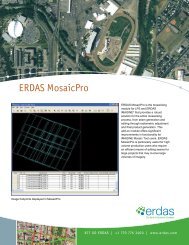
<strong>Leica</strong> MosaicPro features improved seam editing<br />
capabilities, enhanced functionality and improved<br />
radiometric adjustment abilities. With seam editing,<br />
image previewing and a streamlined user interface,<br />
<strong>Leica</strong> MosaicPro increases efficiency through a smooth<br />
process and improved functionality, which ultimately<br />
reduces project time.<br />
ImageEqualizer® corrects variations and flaws in<br />
imagery due to hot spots, vignetting, atmospheric<br />
effects and film processing in scanned aerial<br />
photography or unbalanced satellite images.<br />
Stereo Analyst for IMAGINE is feature extraction, 3D<br />
model generation, interpretation, measurement and<br />
visualization tool which uses stereo imagery to derive<br />
3D information.<br />
The New Standard -<br />
Just a Phone Call Away<br />
You can have it all with the new standard in<br />
photogrammetry — the <strong>Leica</strong> <strong>Photogrammetry</strong><br />
<strong>Suite</strong>, from the company geospatial professionals<br />
have trusted for generations. Take your<br />
photogrammetry technology to the next level<br />
today. Call +1 877 463 7327 or e-mail<br />
info@gi.leica-geosystems.com for more information.