Ancient Geological Sites in Eurobodalla 3.1 MB PDF
Ancient Geological Sites in Eurobodalla 3.1 MB PDF
Ancient Geological Sites in Eurobodalla 3.1 MB PDF

Create successful ePaper yourself
Turn your PDF publications into a flip-book with our unique Google optimized e-Paper software.
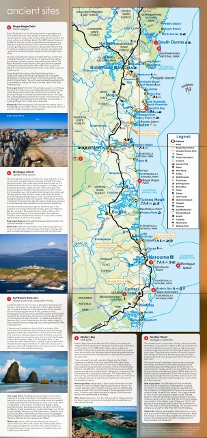
ancient sites<br />
5<br />
B<strong>in</strong>gie B<strong>in</strong>gie Po<strong>in</strong>t<br />
Cool magma<br />
B<strong>in</strong>gie B<strong>in</strong>gie Po<strong>in</strong>t is a site of <strong>in</strong>tense <strong>in</strong>terest to geologists and<br />
their students because of the prolific and spectacular display of<br />
<strong>in</strong>trusive igneous rocks on the northern side of the po<strong>in</strong>t, which lies<br />
at the northern end of B<strong>in</strong>gie Beach. The NSW National Parks and<br />
Wildlife Service says the area is regarded as outstand<strong>in</strong>g among<br />
exposures of igneous <strong>in</strong>trusive rocks <strong>in</strong> New South Wales and is<br />
the ma<strong>in</strong> geological po<strong>in</strong>t of <strong>in</strong>terest <strong>in</strong> <strong>Eurobodalla</strong> National Park.<br />
It is where a complex association of two igneous rock types exists<br />
- granite (Tuross Head tonalite) and gabroic diorite (B<strong>in</strong>gie B<strong>in</strong>gie<br />
suite).<br />
Intrusive rock bodies are masses of magma that have cooled and<br />
crystallized below the earth’s surface as opposed to hav<strong>in</strong>g been<br />
formed from a volcanic eruption and cooled on the surface. The<br />
B<strong>in</strong>gie B<strong>in</strong>gie Po<strong>in</strong>t rocks are part of the early Devonian granites<br />
of the Moruya batholith and are 415 to 390 million years old.A<br />
batholith is a body of rock that has formed <strong>in</strong> the earth’s crust and is<br />
usually granite.<br />
B<strong>in</strong>gie B<strong>in</strong>gie Po<strong>in</strong>t is also on the B<strong>in</strong>gi Dream<strong>in</strong>g Track, a<br />
coastal path used by the Br<strong>in</strong>ja-Yu<strong>in</strong> people prior to European<br />
development. The track is a total of 13.5 km and runs from Congo<br />
south to Tuross Heads. The po<strong>in</strong>t is easily accessible and well worth<br />
a visit whether to explore the rocks or to walk a part of the B<strong>in</strong>gi<br />
Dream<strong>in</strong>g Track.<br />
How to get there: Follow the Pr<strong>in</strong>ces Highway south out of Moruya<br />
for about 9km. Take the turn-off at B<strong>in</strong>gi Road to B<strong>in</strong>gi and Congo.<br />
Follow B<strong>in</strong>gi Road for about 7km until the T-junction and a sign<br />
po<strong>in</strong>t<strong>in</strong>g to B<strong>in</strong>gie Po<strong>in</strong>t and <strong>Eurobodalla</strong> National Park. Turn right<br />
(this is still B<strong>in</strong>gi Road) and follow the road for a few kilometres, then<br />
turn left (aga<strong>in</strong> this is still B<strong>in</strong>gi Road) and follow the road down to<br />
the B<strong>in</strong>gie B<strong>in</strong>gie Po<strong>in</strong>t. There are no amenities.<br />
What to do: Walk amongst the rocks and see the contrast, take <strong>in</strong><br />
the 360 degree view; walk to Tuross or Congo, take a deck chair and<br />
watch for whales; practise your photography.<br />
3<br />
1<br />
2<br />
B<strong>in</strong>gie B<strong>in</strong>gie Po<strong>in</strong>t<br />
48km<br />
4<br />
6<br />
Montague Island<br />
Jewel <strong>in</strong> the crown<br />
This amaz<strong>in</strong>g nature reserve, which has won many awards for its ecotourism<br />
tours, is a seabird haven and is part of the Mt Dromedary<br />
Igneous Complex. The northern part of the island is made up of a<br />
andesite lava extrusion from a volcanic eruption on Gulaga, (or Mt<br />
Dromedary as it is also called), about 95 million years ago <strong>in</strong> the<br />
Cretaceous period. The dark coloured rocks <strong>in</strong> the north contrast<br />
with the southern part of the island, which has been formed through<br />
<strong>in</strong>trusive igneous rocks that have cooled underneath the surface<br />
and been exposed through erosion. These rocks were also formed<br />
through the activity of the ancient volcano. These igneous <strong>in</strong>trusions<br />
<strong>in</strong> the south of the island now take the shape of impressive sculptural<br />
tors that have been well-rounded and smoothed with weather<strong>in</strong>g.<br />
Until about n<strong>in</strong>e thousand years ago the island was part of the<br />
ma<strong>in</strong>land, connect<strong>in</strong>g with Cape Dromedary, just south of Mystery<br />
Bay, by a sand spit. Montague Island is now 9km offshore from<br />
Narooma and of <strong>in</strong>terest to not only geologists, but lighthouse<br />
historians, nature lovers and eco-tourists. It is also a very culturally<br />
significant place to the local Yu<strong>in</strong> people.<br />
How to get there: Book through the Narooma Visitors Centre. You<br />
can book overnight or day trips.<br />
What to do: Help with conservation work; watch the pengu<strong>in</strong>s as<br />
the surf <strong>in</strong>to the rocks <strong>in</strong> the even<strong>in</strong>gs; whale watch <strong>in</strong> spr<strong>in</strong>g; relax,<br />
pa<strong>in</strong>t and take photographs; bird watch and climb the lighthouse.<br />
5<br />
7<br />
6<br />
Igneous rock formation of Montague Island<br />
7<br />
Surf Beach Narooma<br />
Glasshouse rocks and pillow lava<br />
Surf Beach, Narooma has two sites of geological significance and<br />
beauty at either end of the sandy beach, which is approximately<br />
1km <strong>in</strong> length and looks out to Montague Island. At the southern<br />
end lie the impos<strong>in</strong>g Glasshouse Rocks, possibly the most<br />
photographed rocks along the <strong>Eurobodalla</strong> coastl<strong>in</strong>e and have been<br />
recognised by the geological sites and monuments subcommittee<br />
of the <strong>Geological</strong> Society of Australia. The Glasshouse Rocks are<br />
Narooma Chert, a mix of sedimentary chert and shale, are part of<br />
the Cambrian/Ordovician Wagonga Group dat<strong>in</strong>g between 510-440<br />
million years old.<br />
It’s easy to see the aesthetic chevron folds <strong>in</strong> a number of the<br />
rocks, where the sedimentary layers have been squeezed <strong>in</strong>to zig<br />
zag patterns. Although <strong>in</strong>terpretations of ancient tectonics are far<br />
from unanimous, many geologists consider that these rocks came<br />
together as part of a subduction zone, with an ancient Pacific plate<br />
thrust under the eastern edge of the Gondwana plate. At the<br />
northern end of Surf Beach there is a display of igneous pillow lava,<br />
which formed through the lava flow of a submar<strong>in</strong>e volcano or hot<br />
spot also <strong>in</strong> the ancient Pacific Ocean, and made its way to the edge<br />
of the cont<strong>in</strong>ent <strong>in</strong> the subduction process.<br />
Glasshouse Rocks, Narooma<br />
How to get there: The Glasshouse Rocks beg<strong>in</strong> at the southern<br />
headland at the end of Surf Beach. This headland is also home to<br />
Narooma’s cemetery. At low tide you can walk round the headland<br />
to Glasshouse Rocks North Beach and see more of the rocks, which<br />
are impressive <strong>in</strong> their stature. The pillow lava display is easily<br />
accessed along the beach approximately only 300m north of the<br />
Surf Beach car park and amenities. To get to Surf Beach turn off the<br />
Pr<strong>in</strong>ces Highway, Narooma, <strong>in</strong>to Willcocks Avenue, follow this road<br />
down to Surf Beach. (Note Willcocks Avenue turns <strong>in</strong>to Ball<strong>in</strong>galla<br />
Street.) Magnificent views of Glasshouse Rocks may be enjoyed from<br />
Narooma Golf Club and the rise above Surf Beach.<br />
What to do: Have a coffee and someth<strong>in</strong>g to eat; swim; surf;<br />
walk to Glasshouse Rocks and explore the cemetery; take photos<br />
of the mysterious light that comes from the rocks and check out<br />
the beautiful colour, texture and patterns <strong>in</strong> the pillow lava at the<br />
northern end of the beach.<br />
8<br />
Mystery Bay<br />
K<strong>in</strong>k zone<br />
Mystery Bay’s name arises because of the mystery surround<strong>in</strong>g the<br />
disappearance of a government geologist, Lamont Young, his assistant<br />
and three other men <strong>in</strong> 1880, whose mission was to <strong>in</strong>spect new<br />
goldfields. The bay and its dramatic rocks that arise from the sea and<br />
along the shorel<strong>in</strong>e, with Montague Island the brood<strong>in</strong>g backdrop have<br />
also caused locals and tourists to ponder on the mysterious nature of<br />
the place itself.<br />
These rocks which are such a dom<strong>in</strong>ant feature are chert, black<br />
mudstone and slate and date back nearly 500 million years to the<br />
Ordovician period. The outcrops lie <strong>in</strong> a k<strong>in</strong>k zone, mean<strong>in</strong>g they’ve<br />
been subjected to great pressure dur<strong>in</strong>g the mov<strong>in</strong>g of tectonic plates.<br />
A feature called foliation, which has formed dur<strong>in</strong>g movement at high<br />
pressure and which has enabled further deformation, is apparent <strong>in</strong> the<br />
k<strong>in</strong>ks and breaks <strong>in</strong> the angular brittle rocks. This makes these rocks<br />
look as if they could have been pieced together one by one. K<strong>in</strong>k zones<br />
are widely developed, but are particularly well shown <strong>in</strong> this area of<br />
<strong>Eurobodalla</strong>’s coastl<strong>in</strong>e.<br />
How to get there: Mystery Bay is 15km south of Narooma. From the<br />
highway turn left on to Mystery Bay Road and follow to the end. The<br />
car park opposite Lamont Young Drive as you come <strong>in</strong>to Mystery Bay<br />
is where you will f<strong>in</strong>d a memorial plaque to the lost geologist and his<br />
party. It is also a good place to access the display of k<strong>in</strong>k zone rocks<br />
that lie at the northern end of the beach.<br />
What to do: Camp, swim, surf, fish, walk around the village and along<br />
the beach, explore the rockpools, bushwalk <strong>in</strong> <strong>Eurobodalla</strong> National<br />
Park, dive and snorkel.<br />
9<br />
K<strong>in</strong>k zone, Mystery Bay<br />
9<br />
8<br />
Another World<br />
Gulaga’s mysteries<br />
The forested ancient volcano that is Gulaga, also known as Mt<br />
Dromedary, can be seen from Tathra to Moruya, and hides near<br />
its summit magnificent granite tors that are of great spiritual<br />
and cultural significance to the Yu<strong>in</strong> Aborig<strong>in</strong>al people of the<br />
south coast. There have been a number of volcanic eruptions<br />
from Gulaga, the first about 95 million years ago dur<strong>in</strong>g the<br />
Cretaceous period when d<strong>in</strong>osaurs were still at the top of the<br />
food cha<strong>in</strong>.<br />
The volcano has had a significant impact on the surround<strong>in</strong>g<br />
environment with both Little Dromedary (Najanuka) to the<br />
east and Montague Island (Baranguba) formed through the<br />
volcano’s activity. Gulaga, which is now about 800m above sea<br />
level, would have orig<strong>in</strong>ally been close to 2000m higher, and its<br />
foothills would have extended to Tuross. The mounta<strong>in</strong> that you<br />
see today is basically the <strong>in</strong>ner core of the orig<strong>in</strong>al volcano. The<br />
volcano has been dormant s<strong>in</strong>ce the Cretaceous - which ended<br />
65 million years ago.<br />
How to get there: The NSW National Parks and Wildlife<br />
Service and the Gulaga Board of Management consist<strong>in</strong>g<br />
of a majority of Yu<strong>in</strong> Aborig<strong>in</strong>al owners are responsible for<br />
the management of Gulaga National Park and encourage all<br />
visitors to enjoy the walk to the summit. This is approximately<br />
an 11km, 5 hour return trip that is steep <strong>in</strong> parts. The walk<br />
beg<strong>in</strong>s on the path beh<strong>in</strong>d Pam’s General Store at Tilba Tilba.<br />
There are two turn-offs to Tilba Tilba from the Pr<strong>in</strong>ces Highway,<br />
approximately 18 and 16kms south of Narooma. The first will<br />
take you through heritage-listed Central Tilba and then on to<br />
Tilba Tilba which is 3km from the highway. The second turn-off<br />
will take you straight to Tilba Tilba, 1km from the highway.<br />
What to do: Walk<strong>in</strong>g, photography. Take a light picnic <strong>in</strong> your<br />
pack as you walk the path up to the top of the mounta<strong>in</strong>. Enjoy<br />
the changes <strong>in</strong> the surround<strong>in</strong>g vegetation and birdlife as you<br />
go from the lowlands up the mounta<strong>in</strong>, through pockets of<br />
misty ra<strong>in</strong>forest near the summit.<br />
Many thanks to associate professor of earth and environmental sciences<br />
at the University of Wollongong, Chris Fergusson; to the NSW National<br />
Parks and Wildlife Service Narooma branch and to the <strong>Geological</strong><br />
Society of Australia, for cooperation and help with this project.