Ancient Geological Sites in Eurobodalla 3.1 MB PDF
Ancient Geological Sites in Eurobodalla 3.1 MB PDF
Ancient Geological Sites in Eurobodalla 3.1 MB PDF

You also want an ePaper? Increase the reach of your titles
YUMPU automatically turns print PDFs into web optimized ePapers that Google loves.
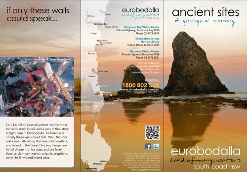
if only these walls<br />
could speak...<br />
Nelligen<br />
Durras<br />
Batemans Bay<br />
Tollgate Islands Batemans Bay Visitor Centre<br />
Pr<strong>in</strong>ces Highway, Batemans Bay 2536<br />
Mogo<br />
Phone 02 4472 6900<br />
ancient sites<br />
Mossy Po<strong>in</strong>t<br />
Broulee Island<br />
Broulee<br />
Information Service<br />
Moruya Library<br />
Vulcan Street, Moruya 2537<br />
Iron stone boxwork, Wasp Head Durras<br />
Moruya<br />
Tuross Head<br />
Narooma Visitor Centre<br />
Pr<strong>in</strong>ces Highway, Narooma 2546<br />
Phone 02 4476 2881<br />
For more ideas on<br />
holiday<strong>in</strong>g <strong>in</strong> <strong>Eurobodalla</strong><br />
or to book your<br />
accommodation & tours<br />
Bodalla<br />
Dalmeny<br />
Narooma<br />
Montague<br />
Island<br />
FREECALL<br />
1800 802 528<br />
www.eurobodalla.com.au<br />
Central Tilba<br />
Tilba Tilba<br />
Mystery Bay<br />
Our 4.6 billion year-old planet has the most<br />
fantastic story to tell, and a part of that story<br />
is right here <strong>in</strong> <strong>Eurobodalla</strong>. It’s been said<br />
‘if only these walls could talk’. Well, the rock<br />
walls and cliffs along this beautiful coastl<strong>in</strong>e,<br />
and <strong>in</strong>land <strong>in</strong> the Great Divid<strong>in</strong>g Range, are<br />
full of chatter - of ice ages and sea level<br />
rises, ancient cont<strong>in</strong>ents, volcanic eruptions,<br />
early life forms and <strong>in</strong>land seas.<br />
SYDNEY•<br />
CANBERRA•<br />
<strong>Eurobodalla</strong><br />
MELBOURNE •<br />
Whilst every endeavour has been made to ensure<br />
the accuracy of the <strong>in</strong>formation conta<strong>in</strong>ed <strong>in</strong> this<br />
publication, <strong>Eurobodalla</strong> Shire Council, their<br />
employees, contractors and agents cannot be<br />
held responsible for any consequences result<strong>in</strong>g<br />
from the use of the <strong>in</strong>formation or errors conta<strong>in</strong>ed<br />
here<strong>in</strong>. All images are copyright of their respective<br />
owners and may not be used <strong>in</strong> any form without<br />
the appropriate permissions. Edition: 06/12<br />
© 2012 <strong>Eurobodalla</strong> Shire Council
a journey back<br />
to ancient times<br />
Giant granite tors, Gulaga<br />
1<br />
Wasp Head South Durras<br />
2<br />
An <strong>in</strong>credible journey<br />
The golden warm colours of the sculpted sandstone cliffs, the exposed<br />
southern edge of the 280 million year old Sydney Bas<strong>in</strong>, are a unique<br />
treat at Wasp Head, but the spectacle doesn’t end with these beautiful<br />
cliffs. Out on the rock ledge of the head, both south and north, you<br />
will f<strong>in</strong>d the most amaz<strong>in</strong>g rock formations and evidence of many<br />
millennia and life that has gone before. You’ll need your camera as<br />
you encounter the honeycomb weather<strong>in</strong>g of the eroded sandstone<br />
on the northern side of the head, from afar this looks like a discarded<br />
fisherman’s net or <strong>in</strong> some places an elaborate spider’s web. While on<br />
the southern side the display of ironstone box work - iron rich sediment<br />
that has been formed <strong>in</strong>to a box-like pattern - is spectacular and is one<br />
of the highlights of Murramarang National Park.<br />
You’ll also see clusters of shellfish fossils, which are clearly evident,<br />
embedded <strong>in</strong> the rocks, as is an old fault plane and igneous dike, with<br />
boulders of petrified magma, (now basalt), clearly visible. Dropstones<br />
and pools of sedimentary conglomerate rock, carried to the area <strong>in</strong> melt<br />
water from west to east as the earth was emerg<strong>in</strong>g from an ancient ice<br />
age, are also visible and contribute to the richness of this site.<br />
Myrtle Beach<br />
Where two worlds collide<br />
A trip to Myrtle Beach is an opportunity to see two worlds collide.<br />
At Myrtle Beach the breathtak<strong>in</strong>g sandstone cliffs of the Sydney<br />
Bas<strong>in</strong> come to an end and rise up to meet the much older Wagonga<br />
Ordovician rocks of the Lachlan Fold Belt, which cont<strong>in</strong>ue south. The<br />
po<strong>in</strong>t where two major geological units meet is called an unconformity<br />
and this unconformity is clearly and strik<strong>in</strong>gly revealed <strong>in</strong> the cliff face<br />
at the northern to middle section of the beach.<br />
The sedimentary rock that forms the massive Sydney Bas<strong>in</strong>, extend<strong>in</strong>g<br />
from Newcastle to the beaches just south of Durras and <strong>in</strong>land to take<br />
<strong>in</strong> the Blue Mounta<strong>in</strong>s, was laid down dur<strong>in</strong>g the Permian and Triassic<br />
periods, between 300 and 230million years ago, while the older<br />
Wagonga Ordovician beds were created 500 to 450 million years ago.<br />
At Myrtle Beach look at the cliffs on the northern end of the beach<br />
– these are the sandstone cliffs that are the southern most exposed<br />
edge of the Sydney Bas<strong>in</strong>, while the cliffs you see at the southern end<br />
of the beach are from the Ordovician period.<br />
Sandstone cliffs of Sydney Bas<strong>in</strong><br />
This world-class gallery of amaz<strong>in</strong>g formations and<br />
folds of sandstone, siltstone, shale, granite and<br />
basalt along <strong>Eurobodalla</strong>’s coast <strong>in</strong> some places<br />
date back as far as 510 million years, while the<br />
coastl<strong>in</strong>e itself was shaped around 90 to 70 million<br />
years ago when the Lord Howe Rise rifted away<br />
from what is now the south-east coast. In recent<br />
times geologically speak<strong>in</strong>g, that is over the last<br />
two to three million years, there has been extensive<br />
variation <strong>in</strong> the sea-level along the east coast<br />
relat<strong>in</strong>g to northern hemisphere glacial periods.<br />
From the stunn<strong>in</strong>g sandstone <strong>in</strong> the north at the<br />
edge of the Sydney Bas<strong>in</strong> at Durras, to the dramatic<br />
chert and mudstone rocks, with their angular faults<br />
and folds, that arise out of the sea at Mystery<br />
Bay, with Montague Island a backdrop and the<br />
unpredictable Tasman Sea lapp<strong>in</strong>g <strong>in</strong>sistently at<br />
your heels, a trip along <strong>Eurobodalla</strong>’s coast and <strong>in</strong>to<br />
the mounta<strong>in</strong> wilderness is a journey through time<br />
you’ll never forget.<br />
www.eurobodalla.com.au<br />
Ironstone box work<br />
How to get there: Wasp Head is about 8.5km from the Pr<strong>in</strong>ces<br />
Highway. Take the South Durras turn-off just 9.6km north of Batemans<br />
Bay and follow it until you reach the Murramarang Resort. Turn left<br />
immediately after the Murramarang Resort car park, travel along<br />
the dirt road for 230 metres, then turn left (no sign) and you’ll drive<br />
downhill to the back of Mill Beach where you will see a car park. From<br />
here you can walk to the Wasp Head rock ledge – north – and at low<br />
tide you can walk right around the head.<br />
To access the southern side of Wasp Head turn left after the<br />
Murramarang Resort car park but <strong>in</strong>stead of turn<strong>in</strong>g left to Mill Beach<br />
go straight ahead for another 200m, where you will f<strong>in</strong>d the Wasp Head<br />
car park. Follow the track straight <strong>in</strong> front of you which is signposted<br />
and clearly def<strong>in</strong>ed, for the first 60m, turn right and connect with an<br />
<strong>in</strong>formal foot track, walk another 60m to the rock ledge. This is a good<br />
access po<strong>in</strong>t dur<strong>in</strong>g high tide, when you won’t be able to walk around<br />
the rock ledge. The closest toilets are at the back of Cookies Beach at<br />
the western side of Murramarang Resort near the boat ramp.<br />
What to do: Look for the clusters of shell fossils; discover the dike on<br />
the southern side of the headland; walk around the headland at low<br />
tide, picnic on the grass near the old boiler on the northern side. Take<br />
artistic photographs of the wonderful rock formations and patterns <strong>in</strong><br />
this unique and beautiful natural gallery.<br />
How to get there: Myrtle Beach is about 9km from the Pr<strong>in</strong>ces<br />
Highway. Take the South Durras turn-off just 9.6km north of Batemans<br />
Bay and follow it until you reach the Murramarang Resort. Keep on the<br />
road and it will take you through the Murramarang Resort car park<strong>in</strong>g<br />
area. Keep travell<strong>in</strong>g south along the Old South Coast Road for just<br />
over 1km until you get to the Dark Beach/Myrtle Beach turn-off where<br />
you turn left, then drive along this road for 450 metres to the ma<strong>in</strong> car<br />
park to access both beaches.<br />
The walk from the car park to Myrtle Beach is approximately 400<br />
metres. The start of the track is fac<strong>in</strong>g you as you enter the car park.<br />
This track heads part of the way east and is signposted - walk for 200<br />
metres, take the first turn right (which is not signposted) walk a further<br />
200 metres, descend the last part via the staircase. The closest public<br />
toilet is near Cookies Beach, next to the Murramarang Resort.<br />
What to do: Walk<strong>in</strong>g, picnick<strong>in</strong>g, swimm<strong>in</strong>g, photography. This is one<br />
of the best spots <strong>in</strong> Murramarang National Park; the walk to the beach<br />
takes you through what the locals call the ‘enchanted forest’, which is<br />
an <strong>in</strong>credible display of stunted spotted gum forests.
3<br />
Guerilla Bay<br />
From the ancient Pacific<br />
Guerilla Bay is one of the most hidden, sheltered and picturesque bays<br />
<strong>in</strong> <strong>Eurobodalla</strong>, and has been formed <strong>in</strong> some of the oldest rocks along<br />
<strong>Eurobodalla</strong>’s coastl<strong>in</strong>e, dat<strong>in</strong>g back 510 million years. These excit<strong>in</strong>g<br />
rock formations and features are layers of chert and slate, <strong>in</strong>itially<br />
laid down <strong>in</strong> the ancient Pacific Ocean - before becom<strong>in</strong>g part of the<br />
Gondwana cont<strong>in</strong>ent possibly dur<strong>in</strong>g an <strong>in</strong>terval of subduction.<br />
A subduction zone is an area where tectonic plates move together or<br />
converge, with one plate overlapp<strong>in</strong>g and overrid<strong>in</strong>g the other. They<br />
can s<strong>in</strong>k to great depths <strong>in</strong> the Earth’s mantle at a 25 to 90 degree<br />
angle. Through the high temperatures and pressures associated with<br />
this process, seabed sediment is converted to rock. Although plate<br />
movement only occurs at a rate of centimetres per year (comparable<br />
to f<strong>in</strong>gernail and toenail growth rates), an active zone such as <strong>in</strong> Japan<br />
or New Zealand, can cause tsunamis and earthquakes. Through plate<br />
movement sediments and rocks can be carried long distances to<br />
become part of land masses.<br />
Squeezed, bent and broken after they formed, possibly as a result of<br />
compressive movement with<strong>in</strong> the ancient subduction zone, these<br />
Guerilla Bay rocks now consist of a mix of fragments called tectonic<br />
melange. Also conta<strong>in</strong>ed <strong>in</strong> these chert rocks are tooth-like microfossils<br />
(less than 1mm) from the gut of ext<strong>in</strong>ct eel-like animals, however a<br />
microscope is needed to see these m<strong>in</strong>ute fossils.<br />
Tectonic melange, Guerilla Bay<br />
How to get there: Guerilla Bay is 13km south of Batemans Bay and<br />
accessible from George Bass Drive. Drive south along the Pr<strong>in</strong>ces Highway<br />
to Mogo, turn left <strong>in</strong>to Tomak<strong>in</strong> Road then left <strong>in</strong>to George Bass Drive. Or<br />
take the scenic coast route from Batemans Bay along Beach Road to George<br />
Bass Drive via Batehaven, Lilli Pilli, Malua Bay and Rosedale. From George<br />
Bass Drive, turn east <strong>in</strong>to Burri Po<strong>in</strong>t Road which takes you to Guerilla Bay.<br />
There is a small car park, a few picnic tables but no other amenities.<br />
Th<strong>in</strong>gs to do: Guerilla Bay is suitable for swimm<strong>in</strong>g, snorkell<strong>in</strong>g and<br />
kayak<strong>in</strong>g <strong>in</strong> calm seas and is the start<strong>in</strong>g po<strong>in</strong>t for the 1.5km Banksia Walk to<br />
Burrewarra Po<strong>in</strong>t. The kids will love the rock pools and climb<strong>in</strong>g the rocks.<br />
4<br />
Bendethera<br />
Sparkl<strong>in</strong>g limestone <strong>in</strong> the mounta<strong>in</strong>s<br />
White limestone <strong>in</strong> the creek bed that runs along the walk<strong>in</strong>g trail lead<strong>in</strong>g<br />
to the Bendethera caves is easily seen and is lovely <strong>in</strong> its natural state.<br />
It’s also a rem<strong>in</strong>der that you’re now walk<strong>in</strong>g through the largest karst<br />
(limestone) area <strong>in</strong> Deua National Park. The walk<strong>in</strong>g trail meanders<br />
along, follow<strong>in</strong>g and cross<strong>in</strong>g Con Creek many times, with the sound<br />
of the bubbl<strong>in</strong>g, flow<strong>in</strong>g water a peaceful, welcome fellow traveller.<br />
About 3km <strong>in</strong>to the walk, cover<strong>in</strong>g the hillside to the right of the trail, is<br />
another feature of the area - the endemic Bendethera wattle (also known<br />
as blue bush). Bendethera wattle is unique to the limestone soils <strong>in</strong> this<br />
region. Depend<strong>in</strong>g on the time of year you can expect to see a display of<br />
shimmer<strong>in</strong>g blue-green foliage or a sea of yellow flowers.<br />
To the left of the trail, and with <strong>in</strong>terpretive signs thanks to the diligence<br />
of the NSW National Parks and Wildlife Service are a number of dol<strong>in</strong>es -<br />
which are circular bowl shaped depressions <strong>in</strong> the limestone. Dol<strong>in</strong>es are<br />
one of many weather<strong>in</strong>g features <strong>in</strong>clud<strong>in</strong>g caves, that form when ra<strong>in</strong>water<br />
dissolves limestone and the solution seeps away through the rock.<br />
Sparkl<strong>in</strong>g limestone<br />
Unique Bendethera wattle<br />
The limestone has been identified as form<strong>in</strong>g <strong>in</strong> a shallow sea dur<strong>in</strong>g<br />
the Silurian Period and is between 440 and 415 million years old.<br />
Limestone consists of calcium carbonate, the ma<strong>in</strong> glu<strong>in</strong>g agent <strong>in</strong><br />
cement. The limestone conta<strong>in</strong>s abundant fossils, the rema<strong>in</strong>s of shell<br />
mar<strong>in</strong>e animals. It predates the Great Divid<strong>in</strong>g Range itself, which<br />
formed from 250 million years BP onward, possibly through uplift<strong>in</strong>g<br />
over the ages and dur<strong>in</strong>g the rift<strong>in</strong>g of the Lord Howe Rise from the<br />
east coast 90 to 70 million years ago.<br />
How to get there: The Bendethera Caves walk<strong>in</strong>g trail is 48km from<br />
Moruya. If driv<strong>in</strong>g south from Batemans Bay on the Pr<strong>in</strong>ces Highway<br />
turn right at the roundabout at Moruya <strong>in</strong>to Campbell Street, which<br />
is the road to Araluen. Campbell St turns <strong>in</strong>to Luck Street, which will<br />
take you out of town for about 3kms then turn left <strong>in</strong>to Womban Road.<br />
Womban Road becomes Little Sugarloaf Road. Follow Little Sugarloaf<br />
for 30km until you get to the Bendethera Fire trail, which is clearly<br />
signposted as the way to Bendethera. Be aware that from this po<strong>in</strong>t on<br />
it is four-wheel-drive access only and there is steep terra<strong>in</strong> and three<br />
river cross<strong>in</strong>gs. Turn left onto the fire trail and follow for 9kms. The only<br />
public toilets are a few kilometres from the walk<strong>in</strong>g trail at a clear<strong>in</strong>g<br />
near the river, where the old homestead was situated.<br />
The walk<strong>in</strong>g trail to the caves is an 8km return trip, and is very steep<br />
<strong>in</strong> its f<strong>in</strong>al stages. If access<strong>in</strong>g the caves take appropriate footwear,<br />
headgear and torches. The wattle and dol<strong>in</strong>es are about 3km along<br />
the track and the walk there is moderately easy with numerous creek<br />
cross<strong>in</strong>gs. Always check <strong>in</strong> with the National Parks and Wildlife Service<br />
as to conditions.<br />
What do to: Get away from it all and camp along the Deua River<br />
near site of the old homestead; bushwalk; explore the caves and the<br />
limestone environment; taste the clear mounta<strong>in</strong> creek water near<br />
its source.For more <strong>in</strong>formation call the National Parks and Wildlife<br />
Service at Narooma on 02 4476 0800.
ancient sites<br />
5<br />
B<strong>in</strong>gie B<strong>in</strong>gie Po<strong>in</strong>t<br />
Cool magma<br />
B<strong>in</strong>gie B<strong>in</strong>gie Po<strong>in</strong>t is a site of <strong>in</strong>tense <strong>in</strong>terest to geologists and<br />
their students because of the prolific and spectacular display of<br />
<strong>in</strong>trusive igneous rocks on the northern side of the po<strong>in</strong>t, which lies<br />
at the northern end of B<strong>in</strong>gie Beach. The NSW National Parks and<br />
Wildlife Service says the area is regarded as outstand<strong>in</strong>g among<br />
exposures of igneous <strong>in</strong>trusive rocks <strong>in</strong> New South Wales and is<br />
the ma<strong>in</strong> geological po<strong>in</strong>t of <strong>in</strong>terest <strong>in</strong> <strong>Eurobodalla</strong> National Park.<br />
It is where a complex association of two igneous rock types exists<br />
- granite (Tuross Head tonalite) and gabroic diorite (B<strong>in</strong>gie B<strong>in</strong>gie<br />
suite).<br />
Intrusive rock bodies are masses of magma that have cooled and<br />
crystallized below the earth’s surface as opposed to hav<strong>in</strong>g been<br />
formed from a volcanic eruption and cooled on the surface. The<br />
B<strong>in</strong>gie B<strong>in</strong>gie Po<strong>in</strong>t rocks are part of the early Devonian granites<br />
of the Moruya batholith and are 415 to 390 million years old.A<br />
batholith is a body of rock that has formed <strong>in</strong> the earth’s crust and is<br />
usually granite.<br />
B<strong>in</strong>gie B<strong>in</strong>gie Po<strong>in</strong>t is also on the B<strong>in</strong>gi Dream<strong>in</strong>g Track, a<br />
coastal path used by the Br<strong>in</strong>ja-Yu<strong>in</strong> people prior to European<br />
development. The track is a total of 13.5 km and runs from Congo<br />
south to Tuross Heads. The po<strong>in</strong>t is easily accessible and well worth<br />
a visit whether to explore the rocks or to walk a part of the B<strong>in</strong>gi<br />
Dream<strong>in</strong>g Track.<br />
How to get there: Follow the Pr<strong>in</strong>ces Highway south out of Moruya<br />
for about 9km. Take the turn-off at B<strong>in</strong>gi Road to B<strong>in</strong>gi and Congo.<br />
Follow B<strong>in</strong>gi Road for about 7km until the T-junction and a sign<br />
po<strong>in</strong>t<strong>in</strong>g to B<strong>in</strong>gie Po<strong>in</strong>t and <strong>Eurobodalla</strong> National Park. Turn right<br />
(this is still B<strong>in</strong>gi Road) and follow the road for a few kilometres, then<br />
turn left (aga<strong>in</strong> this is still B<strong>in</strong>gi Road) and follow the road down to<br />
the B<strong>in</strong>gie B<strong>in</strong>gie Po<strong>in</strong>t. There are no amenities.<br />
What to do: Walk amongst the rocks and see the contrast, take <strong>in</strong><br />
the 360 degree view; walk to Tuross or Congo, take a deck chair and<br />
watch for whales; practise your photography.<br />
3<br />
1<br />
2<br />
B<strong>in</strong>gie B<strong>in</strong>gie Po<strong>in</strong>t<br />
48km<br />
4<br />
6<br />
Montague Island<br />
Jewel <strong>in</strong> the crown<br />
This amaz<strong>in</strong>g nature reserve, which has won many awards for its ecotourism<br />
tours, is a seabird haven and is part of the Mt Dromedary<br />
Igneous Complex. The northern part of the island is made up of a<br />
andesite lava extrusion from a volcanic eruption on Gulaga, (or Mt<br />
Dromedary as it is also called), about 95 million years ago <strong>in</strong> the<br />
Cretaceous period. The dark coloured rocks <strong>in</strong> the north contrast<br />
with the southern part of the island, which has been formed through<br />
<strong>in</strong>trusive igneous rocks that have cooled underneath the surface<br />
and been exposed through erosion. These rocks were also formed<br />
through the activity of the ancient volcano. These igneous <strong>in</strong>trusions<br />
<strong>in</strong> the south of the island now take the shape of impressive sculptural<br />
tors that have been well-rounded and smoothed with weather<strong>in</strong>g.<br />
Until about n<strong>in</strong>e thousand years ago the island was part of the<br />
ma<strong>in</strong>land, connect<strong>in</strong>g with Cape Dromedary, just south of Mystery<br />
Bay, by a sand spit. Montague Island is now 9km offshore from<br />
Narooma and of <strong>in</strong>terest to not only geologists, but lighthouse<br />
historians, nature lovers and eco-tourists. It is also a very culturally<br />
significant place to the local Yu<strong>in</strong> people.<br />
How to get there: Book through the Narooma Visitors Centre. You<br />
can book overnight or day trips.<br />
What to do: Help with conservation work; watch the pengu<strong>in</strong>s as<br />
the surf <strong>in</strong>to the rocks <strong>in</strong> the even<strong>in</strong>gs; whale watch <strong>in</strong> spr<strong>in</strong>g; relax,<br />
pa<strong>in</strong>t and take photographs; bird watch and climb the lighthouse.<br />
5<br />
7<br />
6<br />
Igneous rock formation of Montague Island<br />
7<br />
Surf Beach Narooma<br />
Glasshouse rocks and pillow lava<br />
Surf Beach, Narooma has two sites of geological significance and<br />
beauty at either end of the sandy beach, which is approximately<br />
1km <strong>in</strong> length and looks out to Montague Island. At the southern<br />
end lie the impos<strong>in</strong>g Glasshouse Rocks, possibly the most<br />
photographed rocks along the <strong>Eurobodalla</strong> coastl<strong>in</strong>e and have been<br />
recognised by the geological sites and monuments subcommittee<br />
of the <strong>Geological</strong> Society of Australia. The Glasshouse Rocks are<br />
Narooma Chert, a mix of sedimentary chert and shale, are part of<br />
the Cambrian/Ordovician Wagonga Group dat<strong>in</strong>g between 510-440<br />
million years old.<br />
It’s easy to see the aesthetic chevron folds <strong>in</strong> a number of the<br />
rocks, where the sedimentary layers have been squeezed <strong>in</strong>to zig<br />
zag patterns. Although <strong>in</strong>terpretations of ancient tectonics are far<br />
from unanimous, many geologists consider that these rocks came<br />
together as part of a subduction zone, with an ancient Pacific plate<br />
thrust under the eastern edge of the Gondwana plate. At the<br />
northern end of Surf Beach there is a display of igneous pillow lava,<br />
which formed through the lava flow of a submar<strong>in</strong>e volcano or hot<br />
spot also <strong>in</strong> the ancient Pacific Ocean, and made its way to the edge<br />
of the cont<strong>in</strong>ent <strong>in</strong> the subduction process.<br />
Glasshouse Rocks, Narooma<br />
How to get there: The Glasshouse Rocks beg<strong>in</strong> at the southern<br />
headland at the end of Surf Beach. This headland is also home to<br />
Narooma’s cemetery. At low tide you can walk round the headland<br />
to Glasshouse Rocks North Beach and see more of the rocks, which<br />
are impressive <strong>in</strong> their stature. The pillow lava display is easily<br />
accessed along the beach approximately only 300m north of the<br />
Surf Beach car park and amenities. To get to Surf Beach turn off the<br />
Pr<strong>in</strong>ces Highway, Narooma, <strong>in</strong>to Willcocks Avenue, follow this road<br />
down to Surf Beach. (Note Willcocks Avenue turns <strong>in</strong>to Ball<strong>in</strong>galla<br />
Street.) Magnificent views of Glasshouse Rocks may be enjoyed from<br />
Narooma Golf Club and the rise above Surf Beach.<br />
What to do: Have a coffee and someth<strong>in</strong>g to eat; swim; surf;<br />
walk to Glasshouse Rocks and explore the cemetery; take photos<br />
of the mysterious light that comes from the rocks and check out<br />
the beautiful colour, texture and patterns <strong>in</strong> the pillow lava at the<br />
northern end of the beach.<br />
8<br />
Mystery Bay<br />
K<strong>in</strong>k zone<br />
Mystery Bay’s name arises because of the mystery surround<strong>in</strong>g the<br />
disappearance of a government geologist, Lamont Young, his assistant<br />
and three other men <strong>in</strong> 1880, whose mission was to <strong>in</strong>spect new<br />
goldfields. The bay and its dramatic rocks that arise from the sea and<br />
along the shorel<strong>in</strong>e, with Montague Island the brood<strong>in</strong>g backdrop have<br />
also caused locals and tourists to ponder on the mysterious nature of<br />
the place itself.<br />
These rocks which are such a dom<strong>in</strong>ant feature are chert, black<br />
mudstone and slate and date back nearly 500 million years to the<br />
Ordovician period. The outcrops lie <strong>in</strong> a k<strong>in</strong>k zone, mean<strong>in</strong>g they’ve<br />
been subjected to great pressure dur<strong>in</strong>g the mov<strong>in</strong>g of tectonic plates.<br />
A feature called foliation, which has formed dur<strong>in</strong>g movement at high<br />
pressure and which has enabled further deformation, is apparent <strong>in</strong> the<br />
k<strong>in</strong>ks and breaks <strong>in</strong> the angular brittle rocks. This makes these rocks<br />
look as if they could have been pieced together one by one. K<strong>in</strong>k zones<br />
are widely developed, but are particularly well shown <strong>in</strong> this area of<br />
<strong>Eurobodalla</strong>’s coastl<strong>in</strong>e.<br />
How to get there: Mystery Bay is 15km south of Narooma. From the<br />
highway turn left on to Mystery Bay Road and follow to the end. The<br />
car park opposite Lamont Young Drive as you come <strong>in</strong>to Mystery Bay<br />
is where you will f<strong>in</strong>d a memorial plaque to the lost geologist and his<br />
party. It is also a good place to access the display of k<strong>in</strong>k zone rocks<br />
that lie at the northern end of the beach.<br />
What to do: Camp, swim, surf, fish, walk around the village and along<br />
the beach, explore the rockpools, bushwalk <strong>in</strong> <strong>Eurobodalla</strong> National<br />
Park, dive and snorkel.<br />
9<br />
K<strong>in</strong>k zone, Mystery Bay<br />
9<br />
8<br />
Another World<br />
Gulaga’s mysteries<br />
The forested ancient volcano that is Gulaga, also known as Mt<br />
Dromedary, can be seen from Tathra to Moruya, and hides near<br />
its summit magnificent granite tors that are of great spiritual<br />
and cultural significance to the Yu<strong>in</strong> Aborig<strong>in</strong>al people of the<br />
south coast. There have been a number of volcanic eruptions<br />
from Gulaga, the first about 95 million years ago dur<strong>in</strong>g the<br />
Cretaceous period when d<strong>in</strong>osaurs were still at the top of the<br />
food cha<strong>in</strong>.<br />
The volcano has had a significant impact on the surround<strong>in</strong>g<br />
environment with both Little Dromedary (Najanuka) to the<br />
east and Montague Island (Baranguba) formed through the<br />
volcano’s activity. Gulaga, which is now about 800m above sea<br />
level, would have orig<strong>in</strong>ally been close to 2000m higher, and its<br />
foothills would have extended to Tuross. The mounta<strong>in</strong> that you<br />
see today is basically the <strong>in</strong>ner core of the orig<strong>in</strong>al volcano. The<br />
volcano has been dormant s<strong>in</strong>ce the Cretaceous - which ended<br />
65 million years ago.<br />
How to get there: The NSW National Parks and Wildlife<br />
Service and the Gulaga Board of Management consist<strong>in</strong>g<br />
of a majority of Yu<strong>in</strong> Aborig<strong>in</strong>al owners are responsible for<br />
the management of Gulaga National Park and encourage all<br />
visitors to enjoy the walk to the summit. This is approximately<br />
an 11km, 5 hour return trip that is steep <strong>in</strong> parts. The walk<br />
beg<strong>in</strong>s on the path beh<strong>in</strong>d Pam’s General Store at Tilba Tilba.<br />
There are two turn-offs to Tilba Tilba from the Pr<strong>in</strong>ces Highway,<br />
approximately 18 and 16kms south of Narooma. The first will<br />
take you through heritage-listed Central Tilba and then on to<br />
Tilba Tilba which is 3km from the highway. The second turn-off<br />
will take you straight to Tilba Tilba, 1km from the highway.<br />
What to do: Walk<strong>in</strong>g, photography. Take a light picnic <strong>in</strong> your<br />
pack as you walk the path up to the top of the mounta<strong>in</strong>. Enjoy<br />
the changes <strong>in</strong> the surround<strong>in</strong>g vegetation and birdlife as you<br />
go from the lowlands up the mounta<strong>in</strong>, through pockets of<br />
misty ra<strong>in</strong>forest near the summit.<br />
Many thanks to associate professor of earth and environmental sciences<br />
at the University of Wollongong, Chris Fergusson; to the NSW National<br />
Parks and Wildlife Service Narooma branch and to the <strong>Geological</strong><br />
Society of Australia, for cooperation and help with this project.