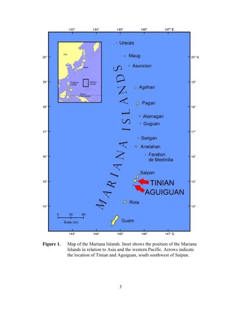
MATERIALS AND METHODS Tinian, <strong>the</strong> third-largest isl<str<strong>on</strong>g>and</str<strong>on</strong>g> in <strong>the</strong> Mariana Isl<str<strong>on</strong>g>and</str<strong>on</strong>g>s, is located between latitude 14E55' N <str<strong>on</strong>g>and</str<strong>on</strong>g> 15E06' N <str<strong>on</strong>g>and</str<strong>on</strong>g> l<strong>on</strong>gitude 145E35' E <str<strong>on</strong>g>and</str<strong>on</strong>g> 145E40' E, some 8 km south southwest <str<strong>on</strong>g>of</str<strong>on</strong>g> Saipan <str<strong>on</strong>g>and</str<strong>on</strong>g> 128 km north <str<strong>on</strong>g>of</str<strong>on</strong>g> Guam (Figure 1). The isl<str<strong>on</strong>g>and</str<strong>on</strong>g> is about 20 km l<strong>on</strong>g <strong>on</strong> its north-south axis <str<strong>on</strong>g>and</str<strong>on</strong>g> 10 km wide <strong>on</strong> its east-west axis, with a l<str<strong>on</strong>g>and</str<strong>on</strong>g> area <str<strong>on</strong>g>of</str<strong>on</strong>g> about 102 km 2 . Basement Eocene volcanic rocks are overlain by Miocene <str<strong>on</strong>g>and</str<strong>on</strong>g> Plio-Pleistocene coral <str<strong>on</strong>g>and</str<strong>on</strong>g> algal limest<strong>on</strong>e <str<strong>on</strong>g>and</str<strong>on</strong>g> Holocene raised beach <str<strong>on</strong>g>and</str<strong>on</strong>g> reef deposits. Doan et al. (1960) mapped <str<strong>on</strong>g>and</str<strong>on</strong>g> described five physiographic divisi<strong>on</strong>s <str<strong>on</strong>g>of</str<strong>on</strong>g> <strong>the</strong> isl<str<strong>on</strong>g>and</str<strong>on</strong>g>: 1) a high, sou<strong>the</strong>rn ridge, where <strong>the</strong> isl<str<strong>on</strong>g>and</str<strong>on</strong>g>’s highest elevati<strong>on</strong> (187 m) is located; 2) a low, median valley that bisects <strong>the</strong> isl<str<strong>on</strong>g>and</str<strong>on</strong>g> in a nor<strong>the</strong>astsouthwest directi<strong>on</strong>; 3) a large central plateau; 4) a small, north-central highl<str<strong>on</strong>g>and</str<strong>on</strong>g> with a maximum elevati<strong>on</strong> <str<strong>on</strong>g>of</str<strong>on</strong>g> 166 m; <str<strong>on</strong>g>and</str<strong>on</strong>g> 5) a nor<strong>the</strong>rn lowl<str<strong>on</strong>g>and</str<strong>on</strong>g> (Figure 2). Aguiguan is a small, steep-sided isl<str<strong>on</strong>g>and</str<strong>on</strong>g> <str<strong>on</strong>g>of</str<strong>on</strong>g> approximately 7.2 km 2 located 8 km southwest <str<strong>on</strong>g>of</str<strong>on</strong>g> Tinian at 14E51' N <str<strong>on</strong>g>and</str<strong>on</strong>g>145E33' E. The isl<str<strong>on</strong>g>and</str<strong>on</strong>g> is composed entirely <str<strong>on</strong>g>of</str<strong>on</strong>g> limest<strong>on</strong>e <str<strong>on</strong>g>and</str<strong>on</strong>g> rises to an elevati<strong>on</strong> <str<strong>on</strong>g>of</str<strong>on</strong>g> 157 m. Most <str<strong>on</strong>g>of</str<strong>on</strong>g> <strong>the</strong> coastline c<strong>on</strong>sists <str<strong>on</strong>g>of</str<strong>on</strong>g> sheer limest<strong>on</strong>e cliffs rising abruptly from <strong>the</strong> sea in a series <str<strong>on</strong>g>of</str<strong>on</strong>g> eight separate terraces (Tayama <str<strong>on</strong>g>and</str<strong>on</strong>g> Ota, 1940). The terraces have been variously grouped into three (Butler, 1992) or four (Tayama <str<strong>on</strong>g>and</str<strong>on</strong>g> Ota, 1940) major terraces. The uppermost terrace forms a nearly flat, central plateau. There are no beaches or embayments (Figure 3). Terrestrial gastropod populati<strong>on</strong>s were surveyed by two methods. For arboreal species, a modificati<strong>on</strong> <str<strong>on</strong>g>of</str<strong>on</strong>g> <strong>the</strong> method used by Hopper <str<strong>on</strong>g>and</str<strong>on</strong>g> Smith (1992) was used. Thirty-minute visual surveys were c<strong>on</strong>ducted by observers in forested areas <str<strong>on</strong>g>of</str<strong>on</strong>g> <strong>the</strong> isl<str<strong>on</strong>g>and</str<strong>on</strong>g>s. Locati<strong>on</strong>s <str<strong>on</strong>g>of</str<strong>on</strong>g> sampling sites were determined by GPS (Garmin ® GPS 72). Presence or absence <str<strong>on</strong>g>of</str<strong>on</strong>g> <str<strong>on</strong>g>snails</str<strong>on</strong>g> was determined by examining leaves <str<strong>on</strong>g>of</str<strong>on</strong>g> broad-leaved tree species, including Hern<str<strong>on</strong>g>and</str<strong>on</strong>g>ia s<strong>on</strong>ora, Guamia mariannae, Cynometra ramiflora, Neisosperma oppositifolia, Ochrosia mariannensis, Mammea odorata, <str<strong>on</strong>g>and</str<strong>on</strong>g> Aglaia mariannensis, which serve as host species for partulids in o<strong>the</strong>r Mariana Isl<str<strong>on</strong>g>and</str<strong>on</strong>g>s. Special emphasis was given to re-visiting sites in Aguiguan where Partula langfordi, an Aguiguan endemic, <str<strong>on</strong>g>and</str<strong>on</strong>g> Partula gibba were reported historically (Craig <str<strong>on</strong>g>and</str<strong>on</strong>g> Ch<str<strong>on</strong>g>and</str<strong>on</strong>g>ran, 1992; Smith, 1995; K<strong>on</strong>do, unpublished data). These species were listed as C<str<strong>on</strong>g>and</str<strong>on</strong>g>idate Species for protecti<strong>on</strong> under <strong>the</strong> U.S. Endangered Species Act. No published records <str<strong>on</strong>g>of</str<strong>on</strong>g> partulid tree snail distributi<strong>on</strong> in Tinian are known; K<strong>on</strong>do (1970) reported Partula gibba from Tinian, but he did not provide locality data. When live arboreal <str<strong>on</strong>g>snails</str<strong>on</strong>g> were located within <strong>the</strong> visual census period, 25-m 2 plots were established under <strong>the</strong> densest understory, as determined by a spherical densiometer. During a 30-min search, all <str<strong>on</strong>g>snails</str<strong>on</strong>g> located to 2 m height within <strong>the</strong> plots were identified to species or collected <str<strong>on</strong>g>and</str<strong>on</strong>g> preserved in 75.5% ethanol for identificati<strong>on</strong> in <strong>the</strong> laboratory. Shell lengths <str<strong>on</strong>g>of</str<strong>on</strong>g> specimens were measured to <strong>the</strong> nearest 0.1 mm with sliding vernier calipers (Digimatic ® 500- 136, Mitutoyo Corp.) or with a Peak ® 10x Scale Loupe. Host tree species were recorded for each snail observed. Leaf litter was examined for 10 min in search <str<strong>on</strong>g>of</str<strong>on</strong>g> fresh partulid ground shells at each sampling site. Observati<strong>on</strong>s <str<strong>on</strong>g>of</str<strong>on</strong>g> dead ground shells were recorded. If no live <str<strong>on</strong>g>snails</str<strong>on</strong>g> or fresh 2
Figure 1. Map <str<strong>on</strong>g>of</str<strong>on</strong>g> <strong>the</strong> Mariana Isl<str<strong>on</strong>g>and</str<strong>on</strong>g>s. Inset shows <strong>the</strong> positi<strong>on</strong> <str<strong>on</strong>g>of</str<strong>on</strong>g> <strong>the</strong> Mariana Isl<str<strong>on</strong>g>and</str<strong>on</strong>g>s in relati<strong>on</strong> to Asia <str<strong>on</strong>g>and</str<strong>on</strong>g> <strong>the</strong> western Pacific. Arrows indicate <strong>the</strong> locati<strong>on</strong> <str<strong>on</strong>g>of</str<strong>on</strong>g> Tinian <str<strong>on</strong>g>and</str<strong>on</strong>g> Aguiguan, south southwest <str<strong>on</strong>g>of</str<strong>on</strong>g> Saipan. 3