

Presentation of SMHI Map Services - Open Geospatial Consortium
Presentation of SMHI Map Services - Open Geospatial Consortium
Presentation of SMHI Map Services - Open Geospatial Consortium

Create successful ePaper yourself
Turn your PDF publications into a flip-book with our unique Google optimized e-Paper software.
<strong>SMHI</strong> <strong>Map</strong> Service <strong>Presentation</strong> - Met Office<br />
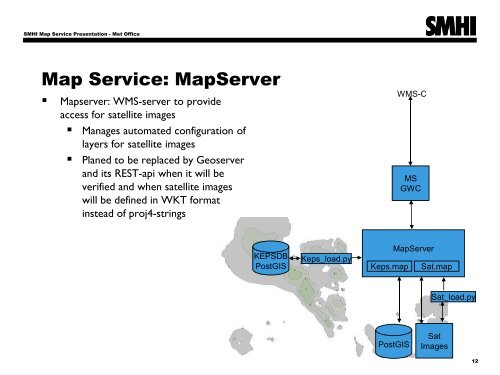
<strong>Map</strong> Service: <strong>Map</strong>Server<br />
• <strong>Map</strong>server: WMS-server to provide<br />
access for satellite images<br />
• Manages automated configuration <strong>of</strong><br />
layers for satellite images<br />
• Planed to be replaced by Geoserver<br />
and its REST-api when it will be<br />
verified and when satellite images<br />
will be defined in WKT format<br />
instead <strong>of</strong> proj4-strings<br />
WMS-C<br />
MS<br />
GWC<br />
KEPSDB<br />
PostGIS<br />
Keps_load.py<br />
Keps.map<br />
<strong>Map</strong>Server<br />
Sat.map<br />
Sat_load.py<br />
PostGIS<br />
Sat<br />
Images<br />
12