

Presentation of SMHI Map Services - Open Geospatial Consortium
Presentation of SMHI Map Services - Open Geospatial Consortium
Presentation of SMHI Map Services - Open Geospatial Consortium

Create successful ePaper yourself
Turn your PDF publications into a flip-book with our unique Google optimized e-Paper software.
<strong>SMHI</strong> <strong>Map</strong> Service <strong>Presentation</strong> - Met Office<br />
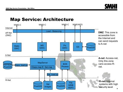
Internet<br />
eR Net<br />
(DMZ)<br />
<strong>Map</strong> Service: Architecture<br />
WMS-C WMS-C<br />
WMS-C WMSWFS<br />
Static<br />
GWC<br />
MS<br />
GWC<br />
Load - Balancing<br />
Pic<br />
GWC<br />
GS<br />
PostGIS<br />
DMZ: This zone is<br />
accessible from<br />
the Internet and<br />
can send requests<br />
to A-net<br />
A-Net<br />
KEPSDB<br />
PostGIS<br />
Keps_load.py<br />
Keps.map<br />
<strong>Map</strong>Server<br />
Sat.map<br />
BOK<br />
Picasso<br />
A-net: Access-net,<br />
Only this zone<br />
cans access R-<br />
net.<br />
Sat_load.py<br />
R-Net<br />
PostGIS<br />
Sat<br />
Images<br />
PostGIS<br />
File<br />
GRIB<br />
HDF5<br />
R-net: Internal<br />
systems with high<br />
security level<br />
9