State of the Mediterranean Marine and Coastal Environment
State of the Mediterranean Marine and Coastal Environment
State of the Mediterranean Marine and Coastal Environment

You also want an ePaper? Increase the reach of your titles
YUMPU automatically turns print PDFs into web optimized ePapers that Google loves.
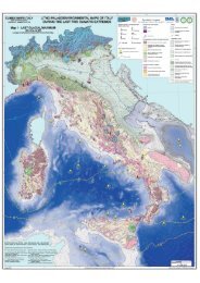
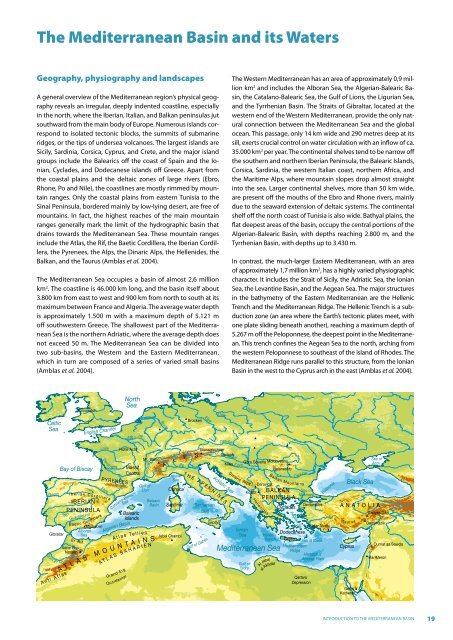
The <strong>Mediterranean</strong> Basin <strong>and</strong> its Waters<br />
Geography, physiography <strong>and</strong> l<strong>and</strong>scapes<br />
A general overview <strong>of</strong> <strong>the</strong> <strong>Mediterranean</strong> region’s physical geography<br />
reveals an irregular, deeply indented coastline, especially<br />
in <strong>the</strong> north, where <strong>the</strong> Iberian, Italian, <strong>and</strong> Balkan peninsulas jut<br />
southward from <strong>the</strong> main body <strong>of</strong> Europe. Numerous isl<strong>and</strong>s correspond<br />
to isolated tectonic blocks, <strong>the</strong> summits <strong>of</strong> submarine<br />
ridges, or <strong>the</strong> tips <strong>of</strong> undersea volcanoes. The largest isl<strong>and</strong>s are<br />
Sicily, Sardinia, Corsica, Cyprus, <strong>and</strong> Crete, <strong>and</strong> <strong>the</strong> major isl<strong>and</strong><br />
groups include <strong>the</strong> Balearics <strong>of</strong>f <strong>the</strong> coast <strong>of</strong> Spain <strong>and</strong> <strong>the</strong> Ionian,<br />
Cyclades, <strong>and</strong> Dodecanese isl<strong>and</strong>s <strong>of</strong>f Greece. Apart from<br />
<strong>the</strong> coastal plains <strong>and</strong> <strong>the</strong> deltaic zones <strong>of</strong> large rivers (Ebro,<br />
Rhone, Po <strong>and</strong> Nile), <strong>the</strong> coastlines are mostly rimmed by mountain<br />
ranges. Only <strong>the</strong> coastal plains from eastern Tunisia to <strong>the</strong><br />
Sinai Peninsula, bordered mainly by low-lying desert, are free <strong>of</strong><br />
mountains. In fact, <strong>the</strong> highest reaches <strong>of</strong> <strong>the</strong> main mountain<br />
ranges generally mark <strong>the</strong> limit <strong>of</strong> <strong>the</strong> hydrographic basin that<br />
drains towards <strong>the</strong> <strong>Mediterranean</strong> Sea. These mountain ranges<br />
include <strong>the</strong> Atlas, <strong>the</strong> Rif, <strong>the</strong> Baetic Cordillera, <strong>the</strong> Iberian Cordillera,<br />
<strong>the</strong> Pyrenees, <strong>the</strong> Alps, <strong>the</strong> Dinaric Alps, <strong>the</strong> Hellenides, <strong>the</strong><br />
Balkan, <strong>and</strong> <strong>the</strong> Taurus (Amblas et al. 2004).<br />
The <strong>Mediterranean</strong> Sea occupies a basin <strong>of</strong> almost 2,6 million<br />
km 2 . The coastline is 46.000 km long, <strong>and</strong> <strong>the</strong> basin itself about<br />
3.800 km from east to west <strong>and</strong> 900 km from north to south at its<br />
maximum between France <strong>and</strong> Algeria. The average water depth<br />
is approximately 1.500 m with a maximum depth <strong>of</strong> 5.121 m<br />
<strong>of</strong>f southwestern Greece. The shallowest part <strong>of</strong> <strong>the</strong> <strong>Mediterranean</strong><br />
Sea is <strong>the</strong> nor<strong>the</strong>rn Adriatic, where <strong>the</strong> average depth does<br />
not exceed 50 m. The <strong>Mediterranean</strong> Sea can be divided into<br />
two sub-basins, <strong>the</strong> Western <strong>and</strong> <strong>the</strong> Eastern <strong>Mediterranean</strong>,<br />
which in turn are composed <strong>of</strong> a series <strong>of</strong> varied small basins<br />
(Amblas et al. 2004).<br />
The Western <strong>Mediterranean</strong> has an area <strong>of</strong> approximately 0,9 million<br />
km 2 <strong>and</strong> includes <strong>the</strong> Alboran Sea, <strong>the</strong> Algerian-Balearic Basin,<br />
<strong>the</strong> Catalano-Balearic Sea, <strong>the</strong> Gulf <strong>of</strong> Lions, <strong>the</strong> Ligurian Sea,<br />
<strong>and</strong> <strong>the</strong> Tyrrhenian Basin. The Straits <strong>of</strong> Gibraltar, located at <strong>the</strong><br />
western end <strong>of</strong> <strong>the</strong> Western <strong>Mediterranean</strong>, provide <strong>the</strong> only natural<br />
connection between <strong>the</strong> <strong>Mediterranean</strong> Sea <strong>and</strong> <strong>the</strong> global<br />
ocean. This passage, only 14 km wide <strong>and</strong> 290 metres deep at its<br />
sill, exerts crucial control on water circulation with an inflow <strong>of</strong> ca.<br />
35.000 km 3 per year. The continental shelves tend to be narrow <strong>of</strong>f<br />
<strong>the</strong> sou<strong>the</strong>rn <strong>and</strong> nor<strong>the</strong>rn Iberian Peninsula, <strong>the</strong> Balearic Isl<strong>and</strong>s,<br />
Corsica, Sardinia, <strong>the</strong> western Italian coast, nor<strong>the</strong>rn Africa, <strong>and</strong><br />
<strong>the</strong> Maritime Alps, where mountain slopes drop almost straight<br />
into <strong>the</strong> sea. Larger continental shelves, more than 50 km wide,<br />
are present <strong>of</strong>f <strong>the</strong> mouths <strong>of</strong> <strong>the</strong> Ebro <strong>and</strong> Rhone rivers, mainly<br />
due to <strong>the</strong> seaward extension <strong>of</strong> deltaic systems. The continental<br />
shelf <strong>of</strong>f <strong>the</strong> north coast <strong>of</strong> Tunisia is also wide. Bathyal plains, <strong>the</strong><br />
flat deepest areas <strong>of</strong> <strong>the</strong> basin, occupy <strong>the</strong> central portions <strong>of</strong> <strong>the</strong><br />
Algerian-Balearic Basin, with depths reaching 2.800 m, <strong>and</strong> <strong>the</strong><br />
Tyrrhenian Basin, with depths up to 3.430 m.<br />
In contrast, <strong>the</strong> much-larger Eastern <strong>Mediterranean</strong>, with an area<br />
<strong>of</strong> approximately 1,7 million km 2 , has a highly varied physiographic<br />
character. It includes <strong>the</strong> Strait <strong>of</strong> Sicily, <strong>the</strong> Adriatic Sea, <strong>the</strong> Ionian<br />
Sea, <strong>the</strong> Levantine Basin, <strong>and</strong> <strong>the</strong> Aegean Sea. The major structures<br />
in <strong>the</strong> bathymetry <strong>of</strong> <strong>the</strong> Eastern <strong>Mediterranean</strong> are <strong>the</strong> Hellenic<br />
Trench <strong>and</strong> <strong>the</strong> <strong>Mediterranean</strong> Ridge. The Hellenic Trench is a subduction<br />
zone (an area where <strong>the</strong> Earth’s tectonic plates meet, with<br />
one plate sliding beneath ano<strong>the</strong>r), reaching a maximum depth <strong>of</strong><br />
5.267 m <strong>of</strong>f <strong>the</strong> Peloponnese, <strong>the</strong> deepest point in <strong>the</strong> <strong>Mediterranean</strong>.<br />
This trench confines <strong>the</strong> Aegean Sea to <strong>the</strong> north, arching from<br />
<strong>the</strong> western Peloponnese to sou<strong>the</strong>ast <strong>of</strong> <strong>the</strong> isl<strong>and</strong> <strong>of</strong> Rhodes. The<br />
<strong>Mediterranean</strong> Ridge runs parallel to this structure, from <strong>the</strong> Ionian<br />
Basin in <strong>the</strong> west to <strong>the</strong> Cyprus arch in <strong>the</strong> east (Amblas et al. 2004).<br />
Celtic<br />
Sea<br />
Duero<br />
Gibraltar<br />
Oum E<br />
Tajo<br />
r Rbi a<br />
A n t i A t l a s<br />
Snowdon<br />
Bay <strong>of</strong> Biscay<br />
I b e r i a n<br />
IBERIAN<br />
PENINSULA<br />
Guadalquivir<br />
B a etic Cord<br />
Adrar Bou<br />
Nasser<br />
Loire<br />
Dord o gne<br />
Ebro<br />
Mulhacen<br />
Alboran<br />
Sea<br />
Er Rif<br />
A T L A S<br />
English Channel<br />
C o r d<br />
illera<br />
PYRENEES<br />
i l e r a<br />
M O U N<br />
A T L A S<br />
Mar<br />
Hohe Acht<br />
ne<br />
Mt. Blanc<br />
Massif<br />
Central<br />
A t l a s Te l<br />
Gr<strong>and</strong> Erg<br />
Sea<br />
Catalano-Balearic<br />
Algerian Basin<br />
Occidental<br />
North<br />
Sea<br />
Balearic<br />
Isl<strong>and</strong>s<br />
Rho ne<br />
Gulf <strong>of</strong><br />
Lion<br />
l i e n<br />
T A I N<br />
S A H A R I E N<br />
Balearic<br />
Basin<br />
S<br />
Rhine<br />
A<br />
L<br />
Jebel Chambi<br />
Po<br />
Ligurian<br />
Sea<br />
Corsica<br />
Sardinia<br />
P<br />
Brocken<br />
S<br />
Elb e<br />
Oder<br />
Danube<br />
Grossglockner<br />
Gerlach<br />
T H E A P E N N I N E S<br />
Tyrrhenian<br />
Sea<br />
Gulf <strong>of</strong> Gabès<br />
Mur<br />
Kkes<br />
Adriatic Sea<br />
Sicily<br />
S ava<br />
Dinaric Alps<br />
Vistula<br />
Gora Goverla Moldoveanu<br />
Balaneshty<br />
Ionian<br />
Sea<br />
Daravica<br />
Korab<br />
Hellenides<br />
BALKAN<br />
PENINSULA<br />
Cyclades<br />
Al Jabal<br />
B a<br />
Hellenic<br />
Trench<br />
<strong>Mediterranean</strong> Sea<br />
Gulf <strong>of</strong><br />
Sidra<br />
al Akhdar<br />
D anube<br />
lkan Mountains<br />
Aegean Sea<br />
Sea <strong>of</strong><br />
Marmara<br />
Qattara<br />
Depression<br />
Dardanelles<br />
Bosporus<br />
Kizlar Sivrisi<br />
Dodecanese<br />
Crete Sea <strong>of</strong> Crete<br />
<strong>Mediterranean</strong><br />
Ridge<br />
Herodotus<br />
Abyssal Plain<br />
Nile<br />
Black Sea<br />
ANATOLIA<br />
Taurus<br />
Cyprus<br />
Gebel<br />
Ka<strong>the</strong>rna<br />
Sea <strong>of</strong><br />
Azov<br />
Erciyes Dagi<br />
Demirkazik<br />
Qurnat as Sawda<br />
Har Meron<br />
INTRODUCTION TO THE MEDITERRANEAN BASIN<br />
19