The State of Arsenic in Nepal - 2003 - Harvard University ...
The State of Arsenic in Nepal - 2003 - Harvard University ...
The State of Arsenic in Nepal - 2003 - Harvard University ...

Create successful ePaper yourself
Turn your PDF publications into a flip-book with our unique Google optimized e-Paper software.
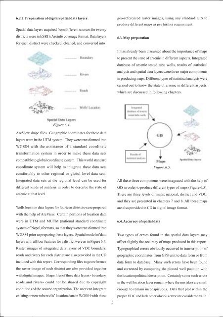
6.2.2. Preparation <strong>of</strong> digital spatial data layers<br />
Spatial data layers acquired from different sources for twenty<br />
districts were <strong>in</strong> ESRI’s Arc<strong>in</strong>fo coverage format. Data layers<br />
for each district were checked, cleaned, and converted <strong>in</strong>to<br />
geo-referenced raster images, us<strong>in</strong>g any standard GIS to<br />
produce different maps as per his/her requirement.<br />
6.3. Map preparation<br />
It has already been discussed about the importance <strong>of</strong> maps<br />
to present the state <strong>of</strong> arsenic <strong>in</strong> different aspects. Integrated<br />
database <strong>of</strong> arsenic tested tube wells, results <strong>of</strong> statistical<br />
analysis and spatial data layers were three major components<br />
<strong>in</strong> produc<strong>in</strong>g maps. Different types <strong>of</strong> statistical analysis were<br />
carried out to know the state <strong>of</strong> arsenic <strong>in</strong> different aspects,<br />
which are discussed <strong>in</strong> follow<strong>in</strong>g chapters.<br />
Figure.6.4.<br />
ArcView shape files. Geographic coord<strong>in</strong>ates for these data<br />
layers were <strong>in</strong> the UTM system. <strong>The</strong>y were transformed <strong>in</strong>to<br />
WGS84 with the assistance <strong>of</strong> a standard coord<strong>in</strong>ate<br />
transformation system <strong>in</strong> order to make these data sets<br />
compatible to global coord<strong>in</strong>ate system. This world standard<br />
coord<strong>in</strong>ate system will help to <strong>in</strong>tegrate these data sets<br />
comfortably to other regional or global level data sets.<br />
Integrated data sets at the regional level can be used for<br />
different k<strong>in</strong>ds <strong>of</strong> analysis <strong>in</strong> order to describe the state <strong>of</strong><br />
arsenic at that level.<br />
Wells location data layers for fourteen districts were prepared<br />
with the help <strong>of</strong> ArcView. Certa<strong>in</strong> portions <strong>of</strong> location data<br />
were <strong>in</strong> UTM and MUTM (national standard coord<strong>in</strong>ate<br />
system <strong>of</strong> <strong>Nepal</strong>) formats, so that they were transformed <strong>in</strong>to<br />
WGS84 prior to prepar<strong>in</strong>g these layers. Spatial model <strong>of</strong> data<br />
layers with all four features for a district were as <strong>in</strong> Figure 6.4.<br />
Raster images <strong>of</strong> <strong>in</strong>tegrated data layers <strong>of</strong> VDC boundary,<br />
roads and rivers for each district are also provided <strong>in</strong> the CD<br />
<strong>in</strong>cluded with this report. Correspond<strong>in</strong>g files to georeference<br />
the raster image <strong>of</strong> each district are also provided together<br />
with digital images. Shape files <strong>of</strong> three data layers - boundary,<br />
roads and rivers- could not be shared due to copyright<br />
conditions <strong>of</strong> the source organization. <strong>The</strong> user can <strong>in</strong>tegrate<br />
exist<strong>in</strong>g or new tube wells’ location data <strong>in</strong> WGS84 with these<br />
15<br />
Figure.6.5.<br />
All these three components were <strong>in</strong>tegrated with the help <strong>of</strong><br />
GIS <strong>in</strong> order to produce different types <strong>of</strong> maps (Figure 6.5).<br />
<strong>The</strong>re are three levels <strong>of</strong> maps: national, district and VDC,<br />
and they are presented <strong>in</strong> chapters 7 and 8. All these maps<br />
are also provided <strong>in</strong> CD <strong>in</strong> digital image format.<br />
6.4. Accuracy <strong>of</strong> spatial data<br />
Two types <strong>of</strong> errors found <strong>in</strong> the spatial data layers may<br />
affect slightly the accuracy <strong>of</strong> maps produced <strong>in</strong> this report.<br />
Typographical errors obviously occurred <strong>in</strong> transcription <strong>of</strong><br />
geographic coord<strong>in</strong>ates from GPS unit to data form or from<br />
data form to database. Many such errors have been found<br />
and corrected by compar<strong>in</strong>g the plotted well position with<br />
the location political description. Certa<strong>in</strong>ly some such errors<br />
<strong>in</strong> the well location layer rema<strong>in</strong> where the mistakes are small<br />
enough to rema<strong>in</strong> <strong>in</strong>conspicuous. Data that plot with<strong>in</strong> the<br />
proper VDC and lack other obvious error are considered valid.