GeoJot+ tablet brochure.pdf - GeoSpatial Experts
GeoJot+ tablet brochure.pdf - GeoSpatial Experts
GeoJot+ tablet brochure.pdf - GeoSpatial Experts

Create successful ePaper yourself
Turn your PDF publications into a flip-book with our unique Google optimized e-Paper software.
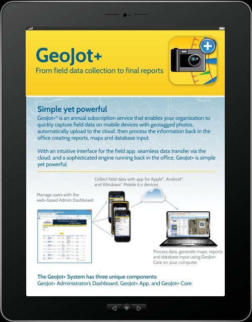
<strong>GeoJot+</strong><br />
From field data collection to final reports<br />
Simple yet powerful<br />
<strong>GeoJot+</strong> ® is an annual subscription service that enables your organization to<br />
quickly capture field data on mobile devices with geotagged photos,<br />
automatically upload to the cloud, then process the information back in the<br />
office creating reports, maps and database input.<br />
With an intuitive interface for the field app, seamless data transfer via the<br />
cloud, and a sophisticated engine running back in the office, <strong>GeoJot+</strong> is simple<br />
yet powerful.<br />
Manage users with the<br />
web-based Admin Dashboard<br />
Collect field data with app for Apple ® , Android ® ,<br />
and Windows ® Mobile 6.x devices<br />
Process data, generate maps, reports<br />
and database input using <strong>GeoJot+</strong><br />
Core on your computer<br />
The <strong>GeoJot+</strong> System has three unique components:<br />
<strong>GeoJot+</strong> Administrator’s Dashboard, <strong>GeoJot+</strong> App, and <strong>GeoJot+</strong> Core.
<strong>GeoJot+</strong> System Features<br />
Field Team Management<br />
• Use app on Android and Apple smartphones<br />
& <strong>tablet</strong>s and Windows Mobile 6.x handheld<br />
GPS units<br />
• Manage all field users under one corporate<br />
account—easily transfer activations from one<br />
device to another ...even across platforms!<br />
• Monitor field data collection in real time<br />
Field Data Collection and<br />
Cloud Data Transfer<br />
• Capture field data through geotagged photos<br />
• Capture multiple images with the same<br />
attribute data<br />
• Create an unlimited number of forms for<br />
data collection<br />
• Distribute forms to field teams for consistent<br />
data collection<br />
• Capture barcode data<br />
• Wirelessly connect with laser rangefinders<br />
• Enhance GPS accuracy on iPhones ® and<br />
iPads ®<br />
• Display GPS location and accuracy on screen<br />
• Set GPS accuracy requirements<br />
• Automatically transfer data via the cloud<br />
• Dynamically rename and organize files<br />
• Collect data in remote or low coverage areas<br />
with offline capabilities<br />
• Review and modify data collected while in<br />
the field<br />
Mapping and Reporting<br />
• Use templates to create<br />
customizable reports<br />
• Create Esri ArcGIS ® shapefiles and<br />
Geodatabases<br />
• Visualize <strong>GeoJot+</strong> data with ArcGIS<br />
extension<br />
• Carry out advanced coordinate<br />
transformations<br />
• Generate Google Earth maps<br />
• QA/QC data enforcing consistency and<br />
quality standards<br />
• Output supports most databases<br />
• Powerful project management tools in<br />
<strong>GeoJot+</strong> Core<br />
Learn more at<br />
www.<strong>GeoSpatial</strong><strong>Experts</strong>.com