Model 114EQ-ASTR - Meade
Model 114EQ-ASTR - Meade
Model 114EQ-ASTR - Meade

Create successful ePaper yourself
Turn your PDF publications into a flip-book with our unique Google optimized e-Paper software.
<strong>Meade</strong><strong>114EQ</strong><strong>ASTR</strong> 3/28/07 9:33 AM Page 8<br />
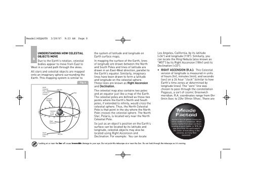
UNDERSTANDING HOW CELESTIAL<br />
OBJECTS MOVE<br />
6<br />
Due to the Earth's rotation, celestial<br />
bodies appear to move from East to<br />
West in a curved path through the skies.<br />
All stars and celestial objects are mapped<br />
onto an imaginary sphere surrounding the<br />
Earth. This mapping system is similar to<br />
17<br />
18<br />
19<br />
16<br />
20<br />
North<br />
Celestial<br />
Pole<br />
(Vicinity of<br />
Polaris)<br />
15<br />
21<br />
South<br />
Celestial<br />
Pole<br />
Celestial<br />
Equator<br />
14<br />
13<br />
Rotation<br />
of the<br />
Earth<br />
12 11<br />
22 23 0 1<br />
Right<br />
Ascension<br />
+90 Déc.<br />
-90 Dec.<br />
Declination<br />
10<br />
2<br />
Star<br />
9<br />
8<br />
4<br />
3<br />
0 Dec.<br />
Fig. 6<br />
7<br />
6<br />
5<br />
the system of latitude and longitude on<br />
Earth surface maps.<br />
In mapping the surface of the Earth, lines<br />
of longitude are drawn between the North<br />
and South Poles and lines of latitude are<br />
drawn in an East-West direction, parallel to<br />
the Earth's equator. Similarly, imaginary<br />
lines have been drawn to form a latitude<br />
and longitude on the celestial sphere.<br />
These lines are known as Right Ascension<br />
and Declination.<br />
The celestial map also contains two poles<br />
and an equator just like a map of the Earth.<br />
The celestial poles are defined as those two<br />
points where the Earth's North and South<br />
poles, if extended to infinity, would cross the<br />
celestial sphere. Thus, the North Celestial<br />
Pole is that point in the sky where the North<br />
Pole crosses the celestial sphere. The North<br />
Star, Polaris, is located very near the North<br />
Celestial Pole.<br />
So just as an object's position on the Earth's<br />
surface can be located by its latitude and<br />
longitude, celestial objects may also be<br />
located using Right Ascension and<br />
Declination. For example: You can locate<br />
Los Angeles, California, by its latitude<br />
(+34°) and longitude (118°). Similarly, you<br />
can locate the Ring Nebula (also known as<br />
"M57") by its Right Ascension (18hr) and its<br />
Declination (+33°).<br />
• RIGHT ASCENSION (R.A.): This Celestial<br />
version of longitude is measured in units<br />
of hours (hr), minutes (min), and seconds<br />
(sec) on a 24 hour "clock" (similar to how<br />
Earth's time zones ar determined by<br />
longitude lines). The "zero" line was<br />
chosen to pass through the constellation<br />
Pegasus, a sort of cosmic Greenwich<br />
meridian. R.A. coordinates range from 0hr<br />
0min 0sec to 23hr 59min 59sec. There are<br />
Jupiter’s four brightest moons are<br />
easily visible in a telescope. When<br />
Galileo Galilei first observed them<br />
rotating around Jupiter in 1610, he<br />
saw proof that the earth wasn’t<br />
the center of everything in the<br />
universe, as many then<br />
supposed.<br />
Looking at or near the Sun will cause irreversible damage to your eye. Do not point this telescope at or near the Sun. Do not look through the telescope as it is moving.