MOHAVE COUNTY REZONING PROCEDURE THE APPLICATION ...
MOHAVE COUNTY REZONING PROCEDURE THE APPLICATION ...
MOHAVE COUNTY REZONING PROCEDURE THE APPLICATION ...

You also want an ePaper? Increase the reach of your titles
YUMPU automatically turns print PDFs into web optimized ePapers that Google loves.
Application Requirements:<br />
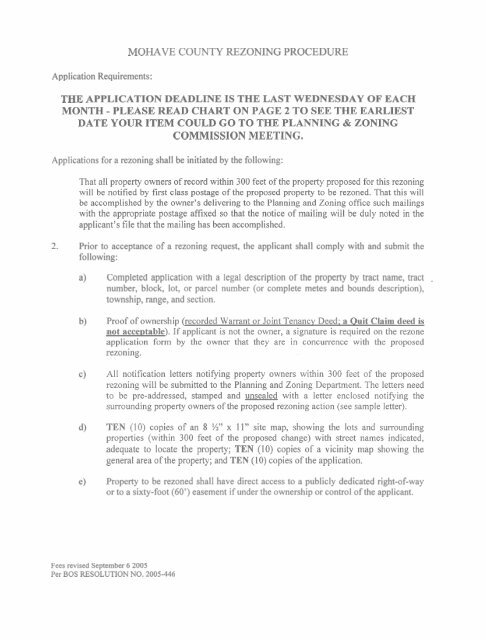
<strong>MOHAVE</strong> <strong>COUNTY</strong> <strong>REZONING</strong> <strong>PROCEDURE</strong><br />
<strong>THE</strong> <strong>APPLICATION</strong> DEADLINE IS <strong>THE</strong> LAST WEDNESDAY OF EACH<br />
MONTH - PLEASE READ CHART ON PAGE 2 TO SEE <strong>THE</strong> EARLIEST<br />
DATE YOUR ITEM COULD GO TO <strong>THE</strong> PLANNING & ZONING<br />
COMMISSION MEETING.<br />
Applications for a rezoning shall be initiated by the following:<br />
That all property owners of record within 300 feet of the property proposed for this rezoning<br />
will be notified by first class postage of the proposed property to be rezoned. That this will<br />
be accomplished by the owner's delivering to the Planning and Zoning office such mailings<br />
with the appropriate postage affixed so that the notice of mailing will be duly noted in the<br />
applicant's file that the mailing has been accomplished.<br />
Prior to acceptance of a rezoning request, the applicant shall comply with and submit the<br />
following:<br />
Completed application with a legal description of the property by tract name, tract -<br />
number, block, lot, or parcel number (or complete metes and bounds description),<br />
township, range, and section.<br />
Proof of ownership (recorded Warrant or Joint Tenancy Deed; a Ouit Claim deed is<br />
not acceptable). If applicant is not the owner, a signature is required on the rezone<br />
application form by the owner that they are in concurrence with the proposed<br />
rezoning.<br />
All notification letters notifying property owners within 300 feet of the proposed<br />
rezoning will be submitted to the planning and Zoning Department. The letters need<br />
to be pre-addressed, stamped and unsealed with a letter enclosed notifying the<br />
surrounding property owners of the proposed rezoning action (see sample letter).<br />
TEN (10) copies of an 8 W x 11" site map, showing the lots and surrounding<br />
properties (within 300 feet of the proposed change) with street names indicated,<br />
adequate to locate the property; TEN (10) copies of a vicinity map showing the<br />
general area of the property; and TEN (10) copies of the application.<br />
Property to be rezoned shall have direct access to a publicly dedicated right-of-way<br />
or to a sixty-foot (60') easement if under the ownership or control of the applicant.<br />
Fees revised September 6 2005<br />
Per BOS RESOLUTION NO. 2005-446
SUBMITTAL DEADLINE<br />
Applications for Rezones, ZUPs, and Extensions of Time for Rezones or ZUPs will not be<br />
considered at a Planning and Zoning Commission meeting sooner than six weeks after the filing<br />
deadline. Applications must be complete and received prior to 12:OO Noon on the last<br />
Wednesday of the month. Incomplete applications will be returned to the applicant or delayed to<br />
a later meeting pending completion of the application or receipt of required supplemental<br />
information. Filing deadlines for the calendar year 2008 are as follows:<br />
Deadline for submittal 12:OO Noon<br />
Date<br />
December 26,2007<br />
January 30,2008<br />
February 27,2008<br />
March 26,2008<br />
April 30,2008<br />
May 28,2008<br />
June 25,2008<br />
July 30,2008<br />
August 27,2008<br />
September 24,2008<br />
October 29,2008<br />
November 26,2008<br />
December 3 1,2008<br />
for<br />
Planning & Zoning Commission Meeting<br />
February 13,2008<br />
March 12,2008<br />
April 9,2008<br />
May 14,2008<br />
June 11,2008<br />
July 9,2008<br />
August 13,2008<br />
September 10,2008<br />
October 8,2008<br />
November 12,2008<br />
December 10,2008<br />
January 14,2009<br />
February 1 1,2009
Mohave County Rezoning Procedure (continued)<br />
Processing fees (updated by BOS Resolution 2007-440 P&Z Ordinance 2007-06<br />
effective 1 01 1 6/07):<br />
From any zone to:<br />
Acreage:<br />
Less than 5 5 - 9.99 10 or more<br />
Agricultural/Residential Zone $540 $640 $740<br />
Any Residential Zone $590 $740 $790<br />
Commercial Zone $740 $890 $1040<br />
Industrial Zone $740 $890 $1040<br />
Special Development Zone $740 $890 $1040<br />
Specific Zoning Plan<br />
$1540 plus $2 per acre<br />
Extension of Time<br />
54 (one half) of Regular Fee (to<br />
include automation fee)<br />
These fees already include a $40 non-refundable automation fee as approved by<br />
the Board of Supervisors Resolution No. 2005-446.<br />
Application to be submitted to:<br />
Mohave County Planning and Zoning Commission<br />
P.O. Box 7000<br />
3675 E. Hwy 66 Ste A<br />
Kingman AZ 86402-7000<br />
(928)757-0903 Fax (928)757-3577
MOHA VE <strong>COUNTY</strong> PLANNING & ZONING DEPARTMENT<br />
P.O. Box 7000 + Kingrnan, Arizona 86402-7000<br />
3675 E. Highway 66, Suite A + (928) 757-0903 + FAX (928) 757-3577<br />
1222 East Hancock Road + Bullhead City, Arizona 86442 (928) 758-0707 + FAX (928) 758-0721<br />
CHRlSTlNE BALLARD<br />
DIRECTOR<br />
Dear Applicant:<br />
Mohave County is asking all applicants for rezones and (zoning) use permits to fill in and sign the<br />
attached waiver form. The following is an explanation of the purpose and effect of the waiver.<br />
Background<br />
Proposition 207 was adopted by Arizona voters on November 7,2006. The Proposition covers two<br />
aspects of land use law. The first aspect was eminent domain or the taking of land for public purpose.<br />
The Proposition defines eminent domain more narrowly than typically defined nationally, but is close<br />
to the definition in the Arizona State Constitution.<br />
The second aspect is the payment to a property owner for any diminution in fair market value<br />
resulting from any change in land use law or the application of the law.<br />
Effect of Proposition 207<br />
Proposition 207 provides that property owners who experience a diminution of value due to a new<br />
land use law or the new application of a land use law can file a claim against the local governmental<br />
entity. There are certain circumstances where the Proposition does not apply:<br />
Property owners have three years from the time the law becomes applicable to file a<br />
claim.<br />
Property owners must show that the diminution in value is a direct result of the land<br />
use regulation.<br />
When property ownership changes, the new owner is subject to all of the new<br />
regulations, unless a regulation has been waived by the local government.<br />
Certain types of regulation are exempt from Proposition 207. These include laws<br />
enacted to comply with a state or federal law; regulations directly aimed at protecting<br />
the public health, safety and welfare (health and building regulations, traffic control,<br />
pollution control); properties considered a public nuisance under common law.<br />
In cases where the property owner's land is not directly regulated by the regulation<br />
or law.<br />
Rezones and (zoning) use permits requested by property owners will fall under Proposition 207.<br />
Potentially, a property owner who obtains a rezone approval from the Board of Supervisors can file a<br />
Proposition 207 claim against Mohave County should the value of the property subsequently<br />
decrease. To be successful, the property owner must prove that the decrease in value is directly the<br />
result of the rezone or the conditions of the rezone.
Mohave County believes that persons who request rezones and (zoning) use permits should bear the<br />
responsibility, good and bad, of their decisions. To this end, Proposition 207 allows local<br />
governments to request that individuals (persons, corporations, etc.) requesting a rezone or (zoning)<br />
use permit be asked to fill out and sign a waiver of their right to file a Proposition 207 claim. The<br />
Board of Supervisors approved the attached form for use.<br />
Mohave County asks that each individual requesting a rezone or (zoning) use permit fill out and sign<br />
the attached waiver form. Completion of this form waives your right to file a claim as a result of any<br />
diminution of property value resulting from the action requested by you via an application form<br />
for a rezone or (zoning) use permit.<br />
If you choose not to fill in the form, Mohave County will process your rezone or (zoning) use permit<br />
application. The Planning and Zoning Commission and/or Board of Supervisors may take into<br />
consideration the lack of a signed waiver form and the likelihood of a future claim when they make a<br />
decision on your application.<br />
Should you have any question, please ask a staff member for clarification.<br />
Sincerely,<br />
Christine Ballard<br />
Director
WAIVER OF CLAIMS FOR DIMINUTION IN VALUE<br />
OF PROPERTY UNDER A.R.S. 12- 1131-1138.<br />
This waiver is executed this d a y of ,200, by<br />
certain land use changes by Mohave County, Arizona (the County).<br />
(the Owner) in conjunction with a request by the Owner for the approval of<br />
RECITALS<br />
WHEREAS, the Owner owns certain real property located within the County which is depicted and legally<br />
described in the attached Exhibit A, incorporated into this agreement (the Property); and<br />
WHEREAS, the Owner has requested that the County enact or approve a certain land use change directly<br />
applicable to the Property; and<br />
WHEREAS, the Owner is aware that, in accordance with the county's land use laws and regulations, the<br />
County may impose various requirements, conditions, and stipulations upon the Property as conditions on the<br />
enactment or approval of land use changes; and<br />
WHEREAS, the Owner understands that the County may rely on the execution of this waiver in determining<br />
whether to enact or approve the requested land use change.<br />
follows:<br />
NOW <strong>THE</strong>REFORE, in consideration of the foregoing, the Owner hereby acknowledges and agrees as<br />
1. The Owner agrees and consents to all the conditions imposed by the County regarding the land use<br />
action:<br />
a. RezoningtZoning Change<br />
b. (Zoning) Use Permit<br />
c. General Plan Amendment<br />
d. Area PlanIArea Plan Amendment<br />
e. Specific Zoning Plan<br />
f. Variance<br />
l3.<br />
h.<br />
Site Plan<br />
Subdivision<br />
I. Ordinance<br />
j.<br />
k.<br />
Development Agreement<br />
WaterIWastewater Service<br />
1. other (please specify)<br />
Referenced in: (ordinance #, application #, permit #)<br />
2. By signing this waiver, the Owner waives any right to claim diminution in value or claim just<br />
compensation for diminution in value under A.R.S. 12-1 131- 1138 related to the land use action as a<br />
result of the County's approval of the action in regards to the Property. This waiver constitutes a<br />
complete release of any and all claims and causes of action that may arise or may be asserted under<br />
A.R.S. 12- 1 13 1 - 1 138 as it exists or may be enacted in the future or that may be amended from time to<br />
time with regard to the Property.<br />
3. This waiver shall not obligate the County to grant the requested land use change or otherwise perform<br />
any legislative, administrative or quasi-judicial act. Without limiting the foregoing, the Owner<br />
understands and acknowledges that the County may rely on the execution of this waiver in<br />
determining whether to grant the requested land use action.
1. This waiver, and any exhibits and addenda attached hereto, constitutes the entire understanding and<br />
agreement of the Owner with respect to claims relating to the specific land use action referenced above.<br />
All prior waivers relating to different land use actions shall remain in full force and effect. This waver<br />
may not be modified or amended except by written agreement between the Owner and the County.<br />
. This waiver runs with the land and is binding upon all present and future owners of the Property.<br />
6. This waiver will be construed and interpreted under the laws of the State of Arizona.<br />
7. Within ten (10) days after the execution of this waiver, the County recorder shall file this waiver in the<br />
Official records of the Recorder's Office, Mohave County, Arizona.<br />
1. The Owner warrants and represents that the Owner holds fee title to the Property, and that no other<br />
person has ownership interest in the Property; and agrees to defend, hold harmless and indemnify the<br />
County in any action regarding ownership and in any action by any party seeking compensation as a<br />
result of the land use action referenced above.<br />
Dated this<br />
day of<br />
Property Owner (any and all owners must sign this agreement. Additional owner's signatures must be<br />
notarized and attached to this waiver)<br />
Print Name:<br />
Print Name:<br />
State of Arizona )<br />
>ss<br />
County of Mohave )<br />
SUBSCRIBED AND SWORN to before me this day of , 20, by,<br />
My Commission Expires:<br />
Notary Public
Mohave County Planning and Zoning Commission<br />
P.O. Box 7000<br />
Kingman Arizona 86402-7000<br />
<strong>APPLICATION</strong> FOR A REZONE<br />
Dear Sir:<br />
I (we)<br />
rezoning of:<br />
hereby request the<br />
(legal description of subject property)<br />
Assessor's Parcel Number (APN)<br />
From:<br />
Proposed to be:<br />
(Current Zoning)<br />
(Proposed Zoning)<br />
For the purpose of:<br />
(Proposed use of Property)<br />
and request that the Board of Supervisors set this matter for public hearing following evaluation<br />
by the Planning and Zoning Commission.<br />
Present use of property:<br />
Owner: (proof required*)<br />
Owner: (address)<br />
Phone:<br />
Property owner concurs:<br />
(Owner's Signature Required)<br />
Zoning<br />
SUBMIT TEN (10) COPIES OF 8 112 X 11 SITE PLAN AND DRAWING WITH<br />
TEN (10) COPIES OF THIS FORM<br />
(TO BE FILLED IN IF OWNER AND APPLICANT DIFFERENT)<br />
Applicant's interest in the property<br />
Applicant:<br />
Address:<br />
City: State: Zip Phone:<br />
*ONE (1) PROOF OF OWNERSHIP: Recorded Warranty or Joint Tenancy Deed; a Quit Claim<br />
Deed is not acceptable.<br />
Date submitted<br />
Received by:<br />
Fee<br />
Receipt No.:<br />
Ten (10) Copies Received:<br />
Application: Other: Sketch:
SAMPLE<br />
Date:<br />
OwnerIApplicant or Agent Name<br />
Address<br />
City, State, Zip<br />
RE: Legal Description of Property<br />
Rezone Request<br />
Dear Property Owner:<br />
I/We (APPLICANT'S NAME) have applied for a change of zone for the above captioned property<br />
from (CURRENT TYPE OF ZONING) to (PROPOSED ZONING) for the purpose of (REASON<br />
FOR REZONE REQUEST). The Mohave County Zoning Ordinance requires all property owners<br />
within 300' of the subject property be notified of this request.<br />
Optional: The enclosed (DOCUMENTATION, MAPS, GRAPHICS) are included for your<br />
reference.<br />
Arizona Revised Statutes, 1 1 -829.C: relating to County Zoning indicates:<br />
If twenty per cent (20%) of the property owners by area and number within the zoning area file<br />
protests to the proposed change, the change shall not be made except by the unanimous vote of all<br />
members of the Board of Supervisors.<br />
Please direct written comments to the Mohave County Planning & Zoning Office at the following<br />
address:<br />
Mohave County Planning & Zoning<br />
P.O. Box 7000<br />
Kingman AZ 86402-7000<br />
(If the applicant is not the owner of the property): As the agent for (OWNER'S NAME), you may<br />
direct your questions or comments to either me or the Mohave County Planning & Zoning Office.<br />
Sincerely,
CHRISTINE BALLARD<br />
DIRECTOR<br />
P.0. Box 7000 + Kingman, Arizona 86402-7000<br />
3675 E. Highway 66, Suite A 4 (928) 757-0903 4 FAX (928)757-3577<br />
1130 East Hancodt Road + Bullhead City, Arizona 86442 + (928) 758-0707 4 FAX (928)763-0870<br />
September 12, 2003<br />
RE:<br />
Rezone applications before the Planning and Zoning Commission for Lots<br />
and /or Parcels with slopes greater than fifteen percent (1 5%).<br />
Dear Applicant:<br />
Beginning with the April 10, 1996 Planning and Zoning Commission meeting,<br />
rezone applications to the Mohave County Planning and Zoning Commission will<br />
require topographic maps as backup information to be submitted along with the<br />
application for lots and/or parcels with slopes areater than fifteen ~ercent (15%).<br />
The following topographic contour intervals, as established by the Mohave County<br />
Subdivision and Road Maintenance Reaulations, 3.6-2, F, area as follows:<br />
Five-foot (5') contour intervals for average slopes of 3 to 15%<br />
Ten-foot (10') contour intervals for average slope gradients over<br />
15%.<br />
The topographic map submitted must have been established from field or aerial<br />
methods by a land surveyor or engineer licensed by the State of Arizona. Copies<br />
of topographic maps of Mohave County may be obtained from acceptable sources<br />
including the Mohave County Public Works Department, the State of Arizona,<br />
United States Geological Survey and others.<br />
Christine Ballard<br />
Director<br />
Planning and Zoning
<strong>REZONING</strong> <strong>APPLICATION</strong> CHECKLIST<br />
I<br />
ITEMS REQUIRED FOR REZONE <strong>APPLICATION</strong><br />
CHECK FOR FEE (DETERMINED BY ACREAGE, SEE FEE CHART)<br />
10 COPIES OF COMPLETED <strong>APPLICATION</strong> WITH OWNER'S<br />
SIGNATURE<br />
10 COPIES OF SITE MAP SHOWING LOCATION AND<br />
DIMENSIONS OF STRUCTURES<br />
10 COPIES OF VICINITY MAP SHOWING GENERAL AREA,<br />
INCLUDING MAJOR STREETS AND PROPERTY ACCESS<br />
NOTIFICATION LETTERS NOTIFYING PROPERTY OWNERS<br />
WITHIN 300 FEET (PRE-ADDRESSED, STAMPED AND<br />
UNSEALED)<br />
ONE (1) COPY OF PROOF OF OWNERSHIP (RECORDED<br />
WARRANTY OR JOINT TENANCY DEED - - A QUIT CLAIM<br />
DEED IS NOT ACCEPTABLE)<br />
WAIVER OF CLAIM FORM COMPLETED, SIGNED, DATED AND<br />
NOTARIZED.