April 2013 (issue 129) - The Sussex Archaeological Society
April 2013 (issue 129) - The Sussex Archaeological Society
April 2013 (issue 129) - The Sussex Archaeological Society
- No tags were found...

Create successful ePaper yourself
Turn your PDF publications into a flip-book with our unique Google optimized e-Paper software.
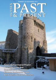
Excavations<br />
BARCOMBE ROMAN BATHS<br />
BARCOMBE ROMAN BATHS<br />
Excavations<br />
Research<br />
Reflections on a Cold Plunge<br />
Reporting on the final year’s dig in Church Field at Barcombe<br />
In October 2012 the bathhouse<br />
excavations at Barcombe were<br />
filled in, thus ending five seasons<br />
of excavations in Church Field<br />
and a total of 14 years of fieldwork<br />
for the Barcombe Roman Villa<br />
Project. It also marked the end<br />
of practical field archaeology at<br />
the University of <strong>Sussex</strong> whose<br />
Centre for Continuing Education<br />
(most recently, until its demise:<br />
Community Engagement) CCE - had<br />
joined the Project as partners of the<br />
Mid <strong>Sussex</strong> Field <strong>Archaeological</strong><br />
Team (MSFAT) in 2006. Over the<br />
years many intriguing features have<br />
been exposed at both the villa and<br />
bathhouse sites. This article reports<br />
upon some of the most interesting<br />
discoveries and outcomes of the<br />
final, very wet, fieldwork in 2012.<br />
<strong>The</strong> Bathhouse:<br />
Cold plunge room<br />
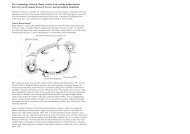
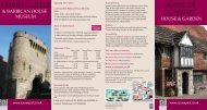
During the five seasons of<br />
excavations starting in 2008 a<br />
rectangular room, approximately<br />
9m by 5.5m, had gradually been<br />
unearthed at the extreme western<br />
end of the complex. It was named<br />
Fig.1 WR2 at the end of 2011.<br />
Photo: D Millum<br />
West Room 2 (WR2) and consisted<br />
of three outer flint walls 700mm<br />
wide to the north, west and south,<br />
all of which had a substantial 1m<br />
wide chalk wall abutting them<br />
internally (Fig.1). On the eastern<br />
side was a shallower 600mm chalk<br />
internal wall adjacent to what<br />
appeared to be a corridor. <strong>The</strong> flint<br />
wall had scattered tegula lying on<br />
its surface which were interpreted<br />
as part of the wall, rather than fallen<br />
roof tiles, as tegula were found, in<br />
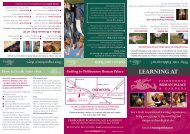
situ, in a lower string course. An<br />
evaluation trench dug to the outside<br />
of the northwest corner showed<br />
a well-built structure with quoins<br />
made from dressed sandstone and<br />
paludina limestone (Fig.2).<br />
Fig.2 <strong>The</strong> NW corner. Scales: 250mm.<br />
Photo: D Millum<br />
Initial theories as to the room’s<br />
function included speculation that<br />
the strength of the walls could<br />
suggest a two-storied structure<br />
or even a watermill. Indeed,<br />
geoarchaeological work by Dr Mike<br />
Allen, and geophysical surveying<br />
by David Staveley, suggest that a<br />
water course passed the structure’s<br />
western flank. However, Ernest<br />
Black felt that the room was a cold<br />
plunge pool and this seemed more<br />
convincing than a counter proposal<br />
of a large latrine.<br />
A priority in 2011 and 2012 was<br />
to investigate the interior of the<br />
room, especially the inside faces<br />
of the walls. As the southwest<br />
quadrant was excavated a scatter<br />
of loose debris on the surface was<br />
resolved into a partition wall across<br />
the room. <strong>The</strong> walls were taken<br />
down internally to their foundations<br />
and a distinct plinth was uncovered<br />
at the base of both the south and<br />
north walls.<br />
Fig.3 Opening in the SW corner. Photo: D Millum<br />
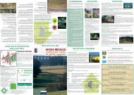
Even more intriguing was the<br />
small square opening at the base<br />
of the extreme south west corner<br />
(Fig. 3). Was this a drain outlet or<br />
water inlet for a cold bath; or did the<br />
plinths imply a suspended floor with<br />
the partition wall merely a sleeper<br />
for bearing joists and the opening<br />
a vent to keep the under-floor area<br />
dry, by drainage and/or ventilation<br />
<strong>The</strong> fuller excavation of this feature<br />
in 2012 recovered part of a copperalloy<br />
spatula and this and a pair of<br />
copper-alloy tweezers from outside<br />
WR2’s southern wall are items<br />
which often form part of Roman<br />
toilet sets. In the north of the room<br />
a black sooty fill to the western side<br />
gave way to a pink opus signinum<br />
layer, with a compacted chalk layer<br />
beneath. Finally the western half of<br />
the partition wall was removed and<br />
distinct differences between the<br />
fills on either side were observed,<br />
with a significant absence of<br />
the opus signinum layer in the<br />
southern area. By the end of the<br />
2012 season, although the interior<br />
of WR2 was fully excavated there<br />
was no evidence that the structure<br />
had been capable of holding water.<br />
However, with so much material<br />
obviously robbed from this building,<br />
possibly within the Roman period,<br />
this lack of evidence could not be<br />
taken as proof that this was always<br />
the case. Another possibility is<br />
that only the smaller southern part<br />
of this room (i.e. the area with the<br />
drain) functioned as a small plunge<br />
pool, whilst the northern part with<br />
its opus signinum floor functioned<br />
as an apodyterium or changing<br />
area.<br />
A bronze ‘wolf and twins’ coin<br />
of c. AD 330-340 was found in the<br />
surface layer of the south east corner<br />
but no datable items were found in<br />
sealed lower contexts. Although this<br />
suggests that WR2 was filled with<br />
sediment by the early 4th century,<br />
it is equally possible that the coin<br />
was a secondary deposition as<br />
part of later sedimentation. <strong>The</strong><br />
black sooty fill in the northwest<br />
corner suggests that this presumed<br />
once recreational building was<br />
subsequently used for a more<br />
industrial purpose.<br />
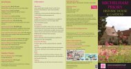
Fig.5 Temperature zone diagram.<br />
Figure 5 aims to explain a<br />
possible temperature zoning for<br />
the bathhouse and shows WR2<br />
placed at the extreme cold end of<br />
the complex and therefore in an<br />
ideal location for a cold wet use<br />
such as a plunge bath. It should be<br />
noted however that we now think<br />
that there may have been at least<br />
three major phases of building at<br />
this site and that the whole building<br />
may not necessarily have been in<br />
use at one time.<br />
Possible Saxon Remains<br />
Earlier in 2012 David Staveley<br />
had undertaken a new geophysical<br />
(magnetometer) survey of<br />
Church Field. <strong>The</strong> most intriguing<br />
discovery revealed was a strange<br />
‘m’ shaped anomaly upslope<br />
from the baths, much nearer to St<br />
Mary’s Church. This anomaly was<br />
further investigated last summer<br />
and a large part of it was exposed<br />
by mechanical excavation (Fig. 6).<br />
Although unfortunately the site has<br />
been badly truncated by ploughing<br />
(many of the features found were<br />
thus very shallow), discoveries<br />
included: a linear south-west northsouth<br />
orientated ditch; two possible<br />
‘wall trenches’ aligned parallel to<br />
the ditch and some 3.5m apart with<br />
one measuring approximately 8m<br />
in length; a large pit filling the gap<br />
between the northern ends of the<br />
two ‘wall trenches’; another large<br />
pit; three postholes and a drain of<br />
probably later date. Some of these<br />
Image: D Millum<br />
features, i.e. the ‘wall trenches’<br />
and the three postholes, may have<br />
formed parts of a timber building.<br />
<strong>The</strong> strange ‘m’ shaped anomaly<br />
thus proved to have been caused<br />
by a combination of some of the<br />
above listed features. Finds, except<br />
charcoal, were few but included<br />
pottery sherds which have been<br />
provisionally identified as Mid<br />
Saxon. It is hoped that C 14 dating<br />
of some of the charcoal will help<br />
to resolve the age of the remains<br />
exposed. Was there perhaps a<br />
shift in settlement focus from the<br />
villa and baths to the vicinity of St<br />
Mary’s Church, with a deliberate<br />
avoidance of areas containing<br />
traces of Roman buildings<br />
Fig.6 <strong>The</strong> North trench after initial cleaning.<br />
Scales: 2m & 500mm. Photo: L Fisher<br />
<strong>The</strong> Maltese Connection<br />
Another important outcome of<br />
the 2012 season at Barcombe was<br />
the success of a Senior Volunteer<br />
exchange project with Heritage<br />
Malta. This Grundtwig (European)<br />
funded project - Inclusive<br />
Archaeology and Cultural Heritage<br />
- involved sending six English, over<br />
50s, volunteers to Malta to work on<br />
the Roman baths at Ghajn Tuffieha<br />
and in return for Heritage Malta<br />
to send six of their Senior staff to<br />
Barcombe. This exchange project<br />
resulted in a sharing of ideas and<br />
methods and the forming of new<br />
friendships, plus Mario Casha’s<br />
brilliantly apt cartoons, an example<br />
of which is shown below.<br />
David Millum, David<br />
Rudling & Chris Butler<br />
Project Directors Chris Butler & David<br />
Rudling, and Site Supervisor David Millum<br />
would like to thank all who have helped<br />
at Barcombe since 1999; the respective<br />
landowners, St Mary’s Church and the<br />
Stroude Family, for their cooperation and<br />
encouragement.<br />
Church Field has now been ploughed and<br />
returned to agricultural use.<br />
<strong>Sussex</strong> Past & Present <strong>April</strong> <strong>2013</strong><br />
www.sussexpast.co.uk www.sussexpast.co.uk <strong>Sussex</strong> Past & Present <strong>April</strong> <strong>2013</strong>