Maidenhead Riverside Conservation Area Appraisal - The Royal ...
Maidenhead Riverside Conservation Area Appraisal - The Royal ...
Maidenhead Riverside Conservation Area Appraisal - The Royal ...
- No tags were found...

Create successful ePaper yourself
Turn your PDF publications into a flip-book with our unique Google optimized e-Paper software.
New gat e<br />
h<br />
olm<br />
House<br />
<strong>The</strong> Wilow s<br />
La n e E n d<br />
Rippledene<br />
Pippins<br />
Sa ti s<br />
<strong>The</strong> Barn<br />
Crofters<br />
Pi n e vi e w<br />
<strong>The</strong> Barn<br />
Ma g p i e Co tt ag e<br />
1<br />
7<br />
Orc har d House<br />
Tudor Lodge<br />
Wynnstay<br />
Nas h Hous e<br />
Sta b l e<br />
Gat e<br />
House<br />
LANE<br />
<strong>The</strong><br />
Pl a yr o om<br />
Eb o r<br />
18<br />
4<br />
Two Gates<br />
6<br />
Talbot Keep<br />
El m wo o d<br />
Bo u l te rs Lo d g e<br />
<strong>The</strong> Lar ch<br />
House<br />
Rosebank<br />
Coogee Bay<br />
House<br />
MeadC ottage<br />
6<br />
14<br />
1a<br />
1<br />
Rivermead<br />
House<br />
Br am b e r<br />
Cotta ge<br />
3<br />
4<br />
5<br />
9<br />
5<br />
Me a dC otta ge<br />
Sq u i re s L o d g e<br />
10<br />
Haluna<br />
2<br />
1<br />
Inglenook<br />
5<br />
3<br />
1<br />
11<br />
Orc har ds<br />
32<br />
<strong>The</strong> Wickets<br />
Me a d en d<br />
6<br />
4<br />
2<br />
By wa y s<br />
33<br />
Taurmead<br />
11<br />
9<br />
7<br />
4<br />
43<br />
45<br />
4<br />
41<br />
8<br />
<strong>The</strong> Pines<br />
Orc har d Le a<br />
7<br />
9<br />
6<br />
11<br />
2<br />
10<br />
5<br />
13<br />
3<br />
Riverholme<br />
12<br />
8<br />
6<br />
15<br />
37<br />
14<br />
9<br />
1<br />
4<br />
7<br />
35<br />
22<br />
3<br />
1<br />
Woodland View<br />
13<br />
RiversWay<br />
26<br />
31<br />
8<br />
9<br />
GreyTiles<br />
Orc har d<br />
Gar dens<br />
<strong>The</strong> W eir Cotta ge<br />
Me ri d i<br />
Vine House<br />
Gre y<br />
1<br />
Clay lands<br />
Tiles<br />
16<br />
5<br />
Glen Cott age<br />
23<br />
25<br />
7<br />
2<br />
1<br />
Horton L odge<br />
1to5<br />
6 to12<br />
<strong>The</strong> Garden House<br />
Glen Hous e<br />
Horton<br />
Gra nge<br />
Archw ay<br />
House<br />
<strong>The</strong> Lodge<br />
<strong>The</strong> Lodge<br />
14<br />
La vi n g to n<br />
<strong>The</strong><br />
Chalet<br />
Blim<br />
2<br />
20<br />
1<br />
Mi l l He ad<br />
(PH)<br />
<strong>The</strong> Belf ry<br />
<strong>The</strong> Weir House<br />
Glen Is land Ga ra ge<br />
5.24m<br />
24.6m<br />
EBS WORTH CL OS E<br />
1<br />
COURT<br />
Landing S tage<br />
Co Cons t Bdy<br />
River Tham<br />
TH E AV ENU E<br />
51<br />
Landing S tage<br />
1<br />
TH E AV ENU E<br />
COURT ROAD<br />
Dr ain<br />
24.1m<br />
FB<br />
MP<br />
El Sub Sta<br />
Pumping<br />
Sta tion<br />
<strong>Maidenhead</strong> Court<br />
Boat H ouse<br />
Landing<br />
Sta ge<br />
MPs<br />
El Sub Sta<br />
Pumping Sta tion<br />
10a<br />
Swimming P ool<br />
Landing S tage<br />
MPs<br />
26<br />
Mi l Rac e<br />
LB<br />
<strong>The</strong> Fosters<br />
Be re s ford<br />
BM 24.48m<br />
CLIVEDEN<br />
MEAD<br />
Ros neath<br />
22<br />
24<br />
24.1m<br />
5<br />
3<br />
39<br />
<strong>Maidenhead</strong> Court<br />
GROVE<br />
28<br />
18<br />
Post<br />
Posts<br />
Glen Island<br />
1 t o6<br />
Works<br />
Track<br />
LOCK MEA D<br />
Mea d Haze<br />
Co Cons t & UA Bdy<br />
Pond<br />
Mi l Rac e<br />
10a<br />
24.1m<br />
10<br />
Tow ing Path<br />
Boat H ouse<br />
Sluice<br />
Weir<br />
LOWER COOKHA MROAD<br />
TU DOR COURT<br />
Lock C ut<br />
Swimming P ool<br />
River Thames<br />
Weir<br />
CR<br />
Glen Island<br />
Swimming<br />
Pool<br />
24.7m<br />
Pumping<br />
Sta tion<br />
Boat H ouse<br />
El Sub Sta<br />
LOCK AVENUE<br />
7<br />
Boat H ouse<br />
Root<br />
Ho<br />
Boat<br />
House<br />
Boat<br />
House<br />
Landing<br />
Sta ge<br />
Mill Race<br />
25.3m<br />
Post<br />
Horsham Reach<br />
Boult er 's<br />
Isla nd<br />
1 t o 5<br />
Croquet Green<br />
Ray Mill Island<br />
BOULTE RS<br />
2 2<br />
3<br />
Car Park<br />
Pumping<br />
Sta tion<br />
25.0m<br />
BM 25.23m<br />
Te lma<br />
FB<br />
Fish Pond<br />
FB<br />
Putting Gree n<br />
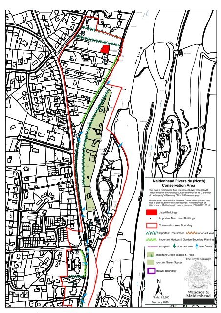
<strong>Maidenhead</strong> <strong>Riverside</strong> (North)<br />
<strong>Conservation</strong> <strong>Area</strong><br />
Pat h<br />
This map is reproduced from Ordnance Survey material with<br />
thepermissionofOrdnanceSurveyonbehalfoftheController<br />
of Her Majesty's Staionery Office © Crown copyright.<br />
Golden Ways<br />
1<br />
MP<br />
Boult er 's<br />
Isla nd<br />
Pat h<br />
Putting<br />
Gre en<br />
PCs<br />
Pat h<br />
Fish Pond<br />
Ra y Mill<br />
Isla nd<br />
Unauthorised reproduction infringes Crown copyright and may<br />
lead to prosecution or civil proceedings. <strong>Royal</strong> Borough of<br />
Windsor and <strong>Maidenhead</strong>. Licence Number 100018817. 2010.<br />
Lock C ut<br />
BOULTERS<br />
CLOSE<br />
MP<br />
FB<br />
Listed Buildings<br />
24.7m<br />
MPs<br />
Bo ulte r' s Co tag es<br />
Boat<br />
House<br />
Important Non Listed Buildings<br />
BOULTE RS LAN E<br />
1<br />
RA Y<br />
4<br />
COURT<br />
MEAD<br />
13<br />
10 12<br />
17<br />
BOULTERS GARDENS<br />
18<br />
TC B<br />
LB<br />
LOWER COOKHAM ROAD<br />
Bollards<br />
Cn<br />
Cn<br />
Bollards<br />
House<br />
Lock<br />
Boult er 's<br />
Lock<br />
Sl<br />
Slipway<br />
FB<br />
Sl<br />
FBs<br />
FB<br />
Tk<br />
Boult er s Inn<br />
MP<br />
<strong>Conservation</strong> <strong>Area</strong> Boundary<br />
Important Tree Screen Important Wall<br />
Important Hedges & Garden Boundary Planting<br />
Cn<br />
25.6m<br />
Bol<br />
Pontoon<br />
Footpath Important Tree View Points<br />
24.7m<br />
RA Y MILL ROAD EAST<br />
BM 24.88m<br />
24.4m<br />
1<br />
Bols<br />
24.1m<br />
Important Green Spaces & Trees<br />
8<br />
CLOSE<br />
HORTON<br />
2<br />
Glen Island<br />
Important Green Spaces<br />
RBWM Boundary<br />
TE RS<br />
COURT<br />
4<br />
7<br />
El Sub Sta<br />
Co Const & UA Bdy<br />
CR<br />
River Thames<br />
Slipway<br />
FB<br />
Mi l Rac e<br />
BOULTERS COURT<br />
3<br />
23.5m<br />
MP<br />
15<br />
MP<br />
Ta plow Court<br />
9<br />
LONG WORTH<br />
DRIVE<br />
1<br />
RA Y M EAD ROAD<br />
BM 23.28m<br />
Landing<br />
Sta ge<br />
MPs<br />
Fn<br />
Scale: 1:3,200<br />
February 2010<br />
St Nic holas 's<br />
Church<br />
(site of)<br />
Memoria l Cross<br />
MP