Herne Bay and Whitstable Landscape appraisal June 2006
Herne Bay and Whitstable Landscape appraisal June 2006
Herne Bay and Whitstable Landscape appraisal June 2006

You also want an ePaper? Increase the reach of your titles
YUMPU automatically turns print PDFs into web optimized ePapers that Google loves.
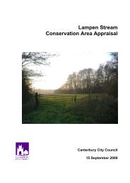
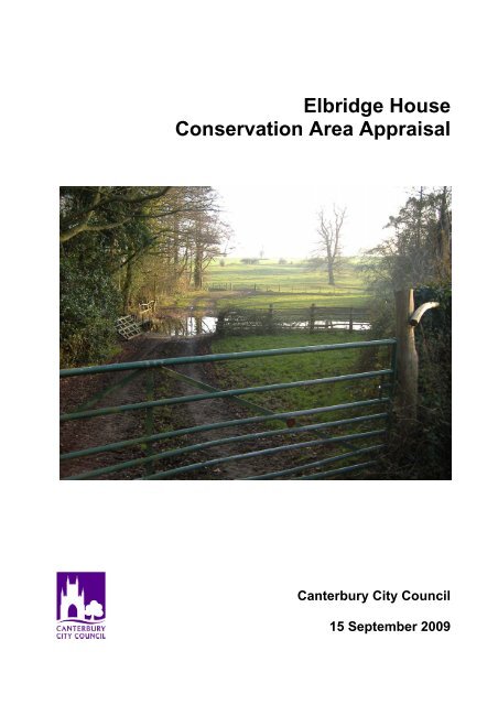
Elbridge House<br />
Conservation Area Appraisal<br />
Canterbury City Council<br />
15 September 2009
Table of Contents<br />
1. Introduction 2<br />
1.1 KEY CHARACTERISTICS 3<br />
1.2 PLANNING POLICY FRAMEWORK 3<br />
National Policy Guidance 3<br />
Regional <strong>and</strong> County Guidance 3<br />
Canterbury City Council Local Plan 3<br />
Heritage, Archaeology <strong>and</strong> Conservation Supplementary Planning Document 4<br />
2. Location <strong>and</strong> Setting 4<br />
2.1 TOPOGRAPHY 4<br />
2.2 BIODIVERSITY ASSESSMENT 5<br />
Trenleypark Wood 5<br />
Swanton Aerial Site 5<br />
Preserving <strong>and</strong> enhancing the wildlife interest 5<br />
3. Archaeology <strong>and</strong> Historic Development. 6<br />
3.1 ARCHAEOLOGY/EVOLUTION 6<br />
3.2 RECENT HISTORY 6<br />
4. Character L<strong>and</strong>scape Setting <strong>and</strong> Connections 7<br />
5. Recommendations 9<br />
5.1 PRIMARY ISSUES 9<br />
5.2 BOUNDARY ASSESSMENT 9<br />
6. Management <strong>and</strong> Improvement 9<br />
7. Statement of Consultation 10<br />
Appendix 11<br />
1. LISTED BUILDINGS DETAILS 11<br />
1
1. Introduction<br />
This <strong>appraisal</strong> examines the key elements that contribute to the special architectural,<br />
natural <strong>and</strong> historic character of Elbridge House Conservation Area. The character of any<br />
area is determined by its topography, location, buildings, natural features <strong>and</strong> open<br />
spaces <strong>and</strong> the age, material <strong>and</strong> style of its buildings. The combination of all these<br />
factors creates a rural atmosphere of a country park <strong>and</strong> in the case of Elbridge House<br />
Conservation Area a unique, special, ‘sense of place’.<br />
Conservation areas were first introduced in<br />
1967 <strong>and</strong> are currently defined as ‘areas of<br />
special architectural or historic interest, the<br />
character or appearance of which it is<br />
desirable to preserve or enhance’ (Section<br />
69 (1) of the Planning (Listed Buildings<br />
<strong>and</strong> Conservation Areas) Act 1990).<br />
The original conservation area was<br />
designated on 28 April 1992. Elbridge<br />
House Park was one of the districts<br />
country parks included in the list of<br />
parkl<strong>and</strong>s that were considered for<br />
designation in the early 1990’s. The houses <strong>and</strong> their l<strong>and</strong>scaped settings were included<br />
within the conservation area to provide protection to their special character.<br />
© © Crown copyright. All rights reserved. Canterbury City<br />
Council Licence No 100019614 (2004). Additional overlaid<br />
information is copyright of Canterbury City Council<br />
Figure 1: Elbridge House Conservation Area <strong>and</strong> Excerpt from Local Plan <strong>2006</strong> Proposals Maps<br />
The City Council considers that the ‘special interest’ justifying designation of a<br />
conservation area should be defined <strong>and</strong> analysed in a written <strong>appraisal</strong> of its character<br />
<strong>and</strong> appearance. This document will be a background paper to the City Council’s Local<br />
Development Framework.<br />
2
1.1 Key Characteristics<br />
1.2 Planning Policy Framework<br />
This <strong>appraisal</strong> concludes that the most significant features<br />
of the Elbridge House Conservation Area are:<br />
• Historic Elbridge house <strong>and</strong> its rural parkl<strong>and</strong> setting<br />
including the pond formed from the Lampen Stream<br />
• Elbridge farmhouse <strong>and</strong> the associated historic farm<br />
buildings especially the Oast House <strong>and</strong> Granary<br />
• Lampen Stream <strong>and</strong> its associated vegetation<br />
• The protected woodl<strong>and</strong> in the southwest of the<br />
conservation area adjacent to Swanton Farm<br />
• The mainly unimproved meadows, fields <strong>and</strong><br />
farml<strong>and</strong> setting, which are bordered by tree belts<br />
<strong>and</strong> hedgerows <strong>and</strong> dotted with specimen trees<br />
• Pockets of woodl<strong>and</strong> <strong>and</strong> individual trees<br />
National Policy Guidance<br />
Government advice on the control of conservation areas <strong>and</strong> historic buildings is set out in<br />
Planning (Listed Buildings <strong>and</strong> Conservation Areas) Act 1990 <strong>and</strong> Planning Policy<br />
Guidance Note 15 – Planning <strong>and</strong> the Historic Environment.<br />
Planning Policy Guidance Notes 12 & 16, the draft South East Plan (March <strong>2006</strong>),<br />
Regional Spatial Strategy, Kent <strong>and</strong> Medway Structure Plan policies <strong>and</strong> Kent Design<br />
Guide provide the general strategic policy context under which the policies in the local<br />
plan function.<br />
Regional <strong>and</strong> County Guidance<br />
The new draft South East plan places importance on the protection of the historic<br />
environment <strong>and</strong> acknowledges the role that the historic environment plays in contributing<br />
towards sustainable development, regeneration, tourism <strong>and</strong> social inclusion. Policy BE7<br />
requires local authorities to adopt policies <strong>and</strong> proposals, which support conservation <strong>and</strong><br />
enhancement of the historic environment. RPG9 sets out key principles for development<br />
in the South East Region.<br />
The Kent & Medway Structure Plan policies also provide the general strategic policy<br />
context. It provides strategic planning polices for the whole county, <strong>and</strong> includes policies<br />
that are particularly relevant to rural areas. Policy QL6: Conservation Areas, sets out<br />
specific policy with respect to conservation areas.<br />
The Kent Design Guide provides a starting point for good design that is well considered<br />
<strong>and</strong> contextually sympathetic, amongst other things. It emphasises the need for the layout<br />
<strong>and</strong> appearance of new development to be based on an <strong>appraisal</strong> of the existing<br />
character.<br />
Canterbury City Council Local Plan<br />
The primary means by which the City Council ensures the preservation <strong>and</strong> enhancement<br />
of the conservation area is through the development control process <strong>and</strong> by applying the<br />
policies of the Canterbury District Local Plan (2001 – 2011). The Local Plan, adopted in<br />
July <strong>2006</strong>, sets out the spatial strategy for the Canterbury District. It includes policies on<br />
housing, the economy, rural housing, the natural <strong>and</strong> built environment, community<br />
infrastructure <strong>and</strong> many others. A number of designations are particularly relevant to<br />
Elbridge, including those relating to conservation areas <strong>and</strong> protected natural areas.<br />
3
Paragraphs 6.83-6.93 of the Local Plan deal with conservation areas <strong>and</strong> include policies<br />
BE7, BE8, BE9 <strong>and</strong> NE5. Policy BE7 provides the primary guidance to developers about<br />
conservation areas.<br />
The planning system has recently changed <strong>and</strong> ultimately a Local Development<br />
Framework (LDF) will replace the Local Plan. The LDF consists of a collection of Local<br />
Development Documents, including the Core Strategy, Proposals Maps, Area Action<br />
Plans, <strong>and</strong> other development plan documents, which may deal with conservation issues<br />
as well as Supplementary Planning Documents<br />
Heritage, Archaeology <strong>and</strong> Conservation Supplementary Planning Document<br />
The Heritage, Archaeology <strong>and</strong> Conservation Supplementary Planning Document was<br />
approved in October 2007. Chapter 4 explains the features that make up a general<br />
conservation <strong>and</strong> are Chapter 5 provides detailed guidance for developments in<br />
Conservation Areas.<br />
2. Location <strong>and</strong> Setting<br />
The Elbridge House Conservation Area is within the Lampen Stream valley between<br />
Trenleypark Wood in the west <strong>and</strong> Stodmarsh in the east. The Lampen Stream rises<br />
about half a mile south of the Canterbury to Littlebourne Road <strong>and</strong> flows in a northeasterly<br />
direction running west to east through the conservation area from Trenleypark<br />
Wood past Elbridge Farm <strong>and</strong> Elbridge House <strong>and</strong> on into the Lampen Stream<br />
Conservation Area to enter the Great Stour north of Stodmarsh.<br />
The Conservation Area includes the former park to Elbridge House, the ornamental<br />
grounds north of Elbridge farm <strong>and</strong> wooded areas to the north, south <strong>and</strong> west. Elbridge<br />
House is situated on the south-facing slope of the Lampen Stream Valley <strong>and</strong> is one of a<br />
small group of attractive historic buildings. The house is set within a small park <strong>and</strong> there<br />
is other ornamental tree planting in the area.<br />
The valley at this point is well wooded.<br />
Most of the l<strong>and</strong> was laid out as formal<br />
parkl<strong>and</strong> setting for the two major houses<br />
<strong>and</strong> the remaining areas included within the<br />
boundary are mostly old un-improved<br />
pasture, woodl<strong>and</strong> <strong>and</strong> l<strong>and</strong> bordering the<br />
Lampen Stream.<br />
The conservation area does not include any<br />
settlements. The built environment consists<br />
of a cluster of buildings near Elbridge House<br />
<strong>and</strong> Elbridge Farmhouse <strong>and</strong> an isolated farmstead <strong>and</strong> cottages, the rest of the<br />
conservation area consists of woods, fields, meadows <strong>and</strong> the Lampen Stream.<br />
2.1 Topography<br />
The Lampen Stream valley is a relatively rare watered valley. It has a weathered<br />
l<strong>and</strong>scape consisting of a wooded stream with fields sloping down to a shallow valley floor<br />
on either side of the stream. Narrow country lanes run along the top ridgelines on either<br />
side of the valley <strong>and</strong> the l<strong>and</strong> flattens out in the south onto a plateau. The base of the<br />
valley is flat <strong>and</strong> has obviously been formed by the stream changing course over many<br />
thous<strong>and</strong>s of years.<br />
4
2.2 Biodiversity Assessment<br />
To the west of this conservation area is Trenleypark Wood, the beginning of a large<br />
ancient woodl<strong>and</strong> complex, which has been declared a Local Wildlife Site by the Kent<br />
Trust for Nature Conservation.<br />
Another Local Wildlife Site is the Swanton Aerial Site part of which is within the<br />
conservation area <strong>and</strong> is covered by an extensive Tree Preservation Order. This is partly<br />
wooded <strong>and</strong> forms a prominent skyline feature when viewed from Elbridge House.<br />
The Trenleypark Wood <strong>and</strong> Swanton<br />
Aerial Site broadleaved woodl<strong>and</strong> Local<br />
Wildlife Sites (LWS) are situated 700 -<br />
1000m to the west of the Conservation<br />
Area.<br />
The southeasterly edge of the<br />
conservation area is mapped in the 2003<br />
Habitat Survey <strong>and</strong> there are good habitat<br />
linkages through swamp, grassl<strong>and</strong>,<br />
pasturel<strong>and</strong>, <strong>and</strong> broadleaved woodl<strong>and</strong><br />
<strong>and</strong> opportunities for species<br />
transgression (“green corridors”)<br />
throughout the conservation area.<br />
Trenleypark Wood<br />
Trenleypark Wood (grid reference TR 191585) was first notified a Local Wildlife Site in<br />
1988. A large ancient woodl<strong>and</strong> complex – one of the few large woods on Tertiary S<strong>and</strong>s<br />
in the north-east of the county, the site consists of broad leaved woodl<strong>and</strong>, running water,<br />
st<strong>and</strong>ing water, scrub, <strong>and</strong> grassl<strong>and</strong>. It was designated for its ancient woodl<strong>and</strong> on acid<br />
soils with 55 ancient woodl<strong>and</strong> indicator plants recorded. Some former s<strong>and</strong> pits are also<br />
included for their wildlife interest. There are good nightingale, warbler <strong>and</strong> woodpecker<br />
populations. Generally, the dominant tree species within the woodl<strong>and</strong> is sweet chestnut,<br />
but other species occur in the relict mixed coppice, including hazel, hornbeam <strong>and</strong> ash.<br />
Oak st<strong>and</strong>ards occur in some parts, while other areas are pure coppice. The state of<br />
management of the woodl<strong>and</strong> varies, with some areas being actively managed <strong>and</strong> others<br />
being unmanaged overstood coppice.<br />
Swanton Aerial Site<br />
Swanton Aerial Site (grid reference TR 202590) was first notified in 1988. It consists of<br />
acid grassl<strong>and</strong> (which provides habitat for a range of invertebrates) <strong>and</strong> a mostly<br />
unmanaged relict ancient broadleaved coppice woodl<strong>and</strong> with oak st<strong>and</strong>ards. Although<br />
the dominant coppice species is sweet chestnut, hornbeam, holly, hazel <strong>and</strong> birch are<br />
other species present. Alder <strong>and</strong> ash coppice occurs along the lowest slopes near the<br />
stream at the western end, <strong>and</strong> several wild service trees are found at the southern end. A<br />
small larch plantation at the northern end of the site is retained for the interest of its<br />
ground flora. Various ancient woodl<strong>and</strong> indicator ground flora species are present on site,<br />
including wood sage Teucrium scorodonia, the native bluebell Hyacinthoides non-scripta,<br />
Dog’s mercury Mercurialis perennis <strong>and</strong> Butcher’s broom Ruscus aculeatus. Badgers are<br />
also known to be present on site.<br />
Preserving <strong>and</strong> enhancing the wildlife interest<br />
The structural diversity <strong>and</strong> water quality of water bodies must be maintained in<br />
accordance with the adjoining grassl<strong>and</strong>, scrubl<strong>and</strong> <strong>and</strong> woodl<strong>and</strong> habitats to provide<br />
plant <strong>and</strong> invertebrate abundance <strong>and</strong> diversity, both of which are important food sources<br />
for a range of birds <strong>and</strong> mammals.<br />
5
The following must be carefully managed to avoid disturbance to the series of special<br />
habitats present in the conservation area, <strong>and</strong> should be considered as part of the<br />
management of any development (following relevant good practice where protected<br />
species (e.g. water voles) are present):<br />
• Sediments entering a nearby or connected water body<br />
• Control or removal of aquatic plants<br />
• Introduction of species<br />
• Control of alien species<br />
• Use of chemicals<br />
• Nutritional enrichment<br />
• Maintenance of ditches <strong>and</strong> water channels to provide shallowly sloping margins to<br />
provide habitat for dragonfly <strong>and</strong> damselfly species<br />
• Impact <strong>and</strong> management of leisure activities<br />
• Water table levels<br />
• Management of scrub<br />
• Provision of scrapes <strong>and</strong> ponds<br />
• Rotational cutting of reedbeds outside of the bird nesting season<br />
• Rotational cutting or intermittent grassl<strong>and</strong> grazing<br />
• Frequency <strong>and</strong> extent of flooding providing beneficial impacts on habitats<br />
• Maintenance of an identified balance between groundwater <strong>and</strong> floodwater levels<br />
• Periodical removal of ditch sediment <strong>and</strong> vegetation<br />
• Field margins <strong>and</strong> hedges<br />
• Sensitive public access<br />
• Sensitive use of machinery (avoid ground compression in sensitive areas)<br />
• Coppice management<br />
• Management of veteran <strong>and</strong> prominent trees in woodl<strong>and</strong> areas <strong>and</strong> the general<br />
l<strong>and</strong>scape<br />
All developments directly or indirectly having an impact upon valued habitats must obtain<br />
an ecological survey by a suitably qualified ecologist. Protected species should always be<br />
considered as part of any development. The impact of a development on biodiversity<br />
should always be considered <strong>and</strong> the biodiversity value enhanced where possible.<br />
There are also a number of agricultural hedgerows within the conservation area that<br />
provide valuable habitat for a number of species. It should be noted that countryside<br />
hedgerows (those not associated with the curtilage of a dwelling) are protected by the<br />
Hedgerow Regulations 1997. These hedgerows cannot be altered (beyond general<br />
maintenance) or removed without 6 weeks prior formal notice being given to the local<br />
planning authority. It should also be noted that the all trees are provided some degree of<br />
protection by the Conservation Area. Any tree located in the conservation area may not be<br />
removed without 6 weeks notice being given to Council.<br />
3. Archaeology <strong>and</strong> Historic Development.<br />
3.1 Archaeology/Evolution<br />
There are no known sites of archaeological interest within the proposed boundaries <strong>and</strong><br />
those, which exist nearby exhibit no recognisable above ground features.<br />
3.2 Recent History<br />
Elbridge House (Listed Grade II) was built about 1803 probably within the site of an earlier<br />
building. Elbridge Farmhouse dates from the 15th century, <strong>and</strong> includes an 18th century<br />
6
granary <strong>and</strong> three 19th century oast kilns. In the 19th century ornamental grounds were<br />
laid out to the north <strong>and</strong> west of this complex <strong>and</strong> some tree belts <strong>and</strong> woodl<strong>and</strong> were<br />
planted to the south on Shepherds Bank. This indicates that the area has been used for<br />
farming <strong>and</strong> a gr<strong>and</strong> family home for at least 600 years.<br />
A comparison of the post 1843 maps with modern maps <strong>and</strong> aerial photos supports the<br />
fact that little has changed in this l<strong>and</strong>scape in the last 150 years beyond some additional<br />
farm buildings.<br />
© © Crown copyright. All rights reserved. Canterbury City Council Licence No 100019614 (2004). Additional overlaid information is copyright of Canterbury City Council<br />
Figure3: Historic map 1843- Figure 4: Aerial photo 2003<br />
4. Character L<strong>and</strong>scape Setting <strong>and</strong> Connections<br />
The valley of Lampen Stream is a particularly attractive feature in this area especially by<br />
contrast with the arable l<strong>and</strong> in intensive monoculture farming on the plateaus on either<br />
side of the valley. It is unusual in that it retains a few historic buildings with traditional<br />
meadows on the slopes into the valley <strong>and</strong> specimen trees as well as substantial copses<br />
of woodl<strong>and</strong> providing a traditional parkl<strong>and</strong> l<strong>and</strong>scape. The meadows are broken up into<br />
smaller fields with the boundaries<br />
defined by hedgerows <strong>and</strong><br />
chestnut wood <strong>and</strong> wire fences.<br />
The ambiance <strong>and</strong> aspect of the<br />
conservation area is one of<br />
isolated farmsteads <strong>and</strong> a gr<strong>and</strong><br />
house set in rural park <strong>and</strong><br />
farml<strong>and</strong> with all of the activities<br />
noises <strong>and</strong> smells that go with it.<br />
The roads in the area are narrow<br />
with soft edges <strong>and</strong> the<br />
boundaries are generally defined<br />
by hedgerows.<br />
The conservation area includes<br />
the former park to Elbridge House, the ornamental grounds north of Elbridge Farm all<br />
contained within the Lampen Stream valley as well as wooded areas to the north, south<br />
<strong>and</strong> west. The whole of this Conservation Area has an unspoiled rural parkl<strong>and</strong><br />
atmosphere. Hedgerows, areas of woodl<strong>and</strong>, shelterbelts <strong>and</strong> specimen trees, punctuate<br />
the l<strong>and</strong>scape. Much of this planting was designated to compliment <strong>and</strong> set off Elbridge<br />
House <strong>and</strong> to improve the views from within the house. The woodl<strong>and</strong> along the ridges to<br />
the north <strong>and</strong> south is very important to views into <strong>and</strong> out of the conservation area<br />
providing a visual screen from the more intensively developed farml<strong>and</strong> beyond.<br />
7
Lampen Stream creates interest along the<br />
valley floor its winding path is bordered by<br />
trees. The small artificial lake created as<br />
part of the Elbridge House Park provides a<br />
focus in the centre of the Conservation<br />
Area. There are particularly attractive views<br />
from the north-south road, which dips into<br />
the valley <strong>and</strong> from Hollybush Lane <strong>and</strong><br />
Swanton Lane across the valley. Elbridge<br />
House <strong>and</strong> its park setting are also very<br />
visible from Swanton Lane. Also of note is<br />
the wooded area of Shepherds Bank, which<br />
provides an attractive backdrop to the<br />
conservation when viewed from the east.<br />
The Conservation Area has few buildings just two clusters of farmsteads <strong>and</strong> rural<br />
houses. The majority of the buildings are located in the north of the conservation area<br />
adjacent to Lampen Stream on the valley floor.<br />
Elbridge House (Listed Grade II) was built about 1803 by the Denne Family. The house is<br />
of buff brick with a Tuscan porch. Ornamental grounds were laid out to the south <strong>and</strong> east<br />
with considerable tree planting including specimen trees on the slope to the south, tree<br />
belts <strong>and</strong> clumps as well as Longshop Wood. The Lampen Stream flows through the<br />
grounds <strong>and</strong> has been widened to form a small lake with an isl<strong>and</strong> below the house.<br />
Elbridge Farmhouse on the west side of Elbridge Hill is listed grade II* <strong>and</strong> is a 15th<br />
century timber framed <strong>and</strong> close-studded ‘Wealden’ hall house. To the north is an 18th<br />
century weather-boarded granary on 16 staddle stones, <strong>and</strong> a tiled roof 18th Century<br />
weather-boarded outbuilding with three 19th century cylindrical red brick oast kilns<br />
attached. Both are listed grade II <strong>and</strong> form an important group with the farmhouse. In the<br />
19th century ornamental grounds were laid out to the north <strong>and</strong> west of this complex <strong>and</strong><br />
some tree belts <strong>and</strong> woodl<strong>and</strong> were planted to the south on Shepherds Bank.<br />
Of additional interest within the meadow which runs down to Lampen Stream from<br />
Hollybush Lane is a World War II blockhouse or pillbox which marks one of the proposed<br />
lines of defence" in case of invasion.<br />
Swanton Farmhouse is located approximately 800m to the south of Elbridge farm in<br />
Swanton wood. It is an 18th century grade listed II red brick property. Swanton Cottage is<br />
adjacent <strong>and</strong> is locally listed.<br />
8
5. Recommendations<br />
5.1 Primary Issues<br />
For a seemingly sleepy rural area there are a number of potential issues facing the<br />
Elbridge House conservation area.<br />
Large-scale modern development in the conservation area would compromise the<br />
character <strong>and</strong> appearance of this area. The use of inappropriate materials <strong>and</strong> building<br />
methods would also impact substantially. The scope for new buildings or extensions is<br />
limited due the impact they would have on the setting of the current buildings <strong>and</strong> within<br />
wider parkl<strong>and</strong>/rural l<strong>and</strong>scape.<br />
The most visible feature of the conservation<br />
area is the single specimen trees, hedgerows<br />
<strong>and</strong> wooded copses lining the valley slopes,<br />
floor <strong>and</strong> ridgelines. Retention of these trees<br />
especially the single st<strong>and</strong>ards <strong>and</strong> woodl<strong>and</strong>s<br />
is important.<br />
A particular threat to this l<strong>and</strong>scape would be<br />
the subdivision or amalgamation of plots<br />
causing the loss of field boundaries or more<br />
buildings. Large-scale intensive farming <strong>and</strong><br />
amalgamation of fields would result in the bare<br />
l<strong>and</strong>scape seen on the plateaus surrounding the valley. Increasing pressure for expansion<br />
<strong>and</strong> modernisation especially from Canterbury’s growing population, <strong>and</strong> the general wish<br />
to live in the countryside not far from town <strong>and</strong> city centres, may, in the future, put<br />
pressure on this area for subdivision for the creation of building plots <strong>and</strong> reuse of farm<br />
buildings as dwellings.<br />
An important feature of the conservation area is the stream valley. The primary issue<br />
facing the Lampen Stream would be the loss of the stream due to water take for domestic<br />
or irrigation purposes. Adjacent intensive farming practices <strong>and</strong> l<strong>and</strong> uses could also<br />
impact upon the health of the stream through nutrification <strong>and</strong> topsoil run off. Protection of<br />
water flows <strong>and</strong> the health of the stream is important in protecting the values of this<br />
conservation area.<br />
5.2 Boundary Assessment<br />
The Elbridge House Conservation Area is unusual in that it includes large areas of<br />
woodl<strong>and</strong>, meadows, trees, rural hinterl<strong>and</strong> <strong>and</strong> a stream. The current boundary takes in<br />
all of the area necessary to protect the parkl<strong>and</strong> setting of the listed buildings near<br />
Elbridge House, as well as the setting of the other listed buildings within the conservation<br />
area <strong>and</strong> the stream <strong>and</strong> woodl<strong>and</strong>s.<br />
6. Management <strong>and</strong> Improvement<br />
There will be a presumption against any further development within the Elbridge House<br />
Conservation Area <strong>and</strong> in future, applicants will have to demonstrate that; not only have<br />
they complied with the general conservation area policies, but, that the proposal does not<br />
involve the loss of woodl<strong>and</strong>s, trees or hedgerows or the widening of roadways or<br />
junctions. In addition, in order to be successful, any new development proposals will need<br />
to be prepared by knowledgeable <strong>and</strong> sensitive designers who can satisfy the City Council<br />
that their proposals will positively enhance the Conservation Area <strong>and</strong> can be achieved<br />
without the loss of gaps, views, or more significantly, open spaces.<br />
9
There is a need to ensure that all future developments in the conservation area respect<br />
the local distinctiveness of Elbridge House Conservation Area, hence some guidance has<br />
been provided below. The key issue is maintenance <strong>and</strong> improvement of those aspects<br />
that contribute to the character <strong>and</strong> quality of the parkl<strong>and</strong> setting <strong>and</strong> scenery.<br />
• Any new development should have a visual underst<strong>and</strong>ing of the historic roots of the<br />
conservation area as a rural farmstead <strong>and</strong> gr<strong>and</strong> house with associated parkl<strong>and</strong> in<br />
a watered valley <strong>and</strong> all that that entails.<br />
• Protection of the current built environment in particular the grade II <strong>and</strong> grade II*<br />
listed buildings.<br />
• Use of in keeping construction materials.<br />
• Ensuring the scale of extensions <strong>and</strong> new buildings are in keeping. It is important that<br />
any change or enlargement does not swamp the few existing buildings.<br />
• Any new development should have close regard to the traditional building styles,<br />
forms, materials <strong>and</strong> techniques characteristic of this area, including the very low<br />
intensity of development. The height, size, design, roofspace, plot width <strong>and</strong> visual<br />
appearance of new development <strong>and</strong> the design of any new vehicle access should<br />
respect the character of the conservation area.<br />
• Protection of the views into, across <strong>and</strong> out of all parts of this conservation area.<br />
• The woodl<strong>and</strong>s, hedgerows <strong>and</strong> individual trees within the Conservation Area should<br />
be retained <strong>and</strong> protected as they make up an important part of the setting.<br />
• Current field boundaries should be retained <strong>and</strong> maintained <strong>and</strong> fields <strong>and</strong> meadows<br />
should not be amalgamated or subdivided.<br />
• Boundary treatments should be traditional such as hedges or wire <strong>and</strong> chestnut post<br />
fences where these are appropriate.<br />
• The water flows <strong>and</strong> health of the stream <strong>and</strong> its immediate surrounds should not be<br />
impacted upon by removal of water from the stream <strong>and</strong>/or use of adjacent l<strong>and</strong>.<br />
When considering new development this need not necessarily mean exact copying of<br />
earlier styles in new work though on occasion this may be the only way. But it does<br />
require developer <strong>and</strong> designer to come to an underst<strong>and</strong>ing of, <strong>and</strong> a respect for, the<br />
character of the area when drawing up their proposals. Every new proposal within the<br />
conservation area should be backed up by a thorough analysis of the site <strong>and</strong> its historic<br />
context. This exercise should ‘inform’ the design process <strong>and</strong> be part of a design<br />
statement submitted with a planning application.<br />
7. Statement of Consultation<br />
A copy of the draft Conservation Area Appraisal has been sent to the Parish Council, all<br />
residents, interest groups <strong>and</strong> local councillors. The formal period for consultation is 29<br />
May 2009 to 26 <strong>June</strong> 2009 <strong>and</strong> responses were received up until 28 July 2009. Two<br />
responses were received.<br />
The draft Conservation Area Appraisal was reported to the Canterbury City Council Rural<br />
Area Members Panel on 16 <strong>June</strong> 2009 for their comment. The Conservation Area<br />
Appraisal was then amended in light of the consultation <strong>and</strong> presented to the<br />
Development Control Committee along with a summary of any responses received on 15<br />
September 2009. One speaker was heard at the meeting. The Development Control<br />
Committee formally adopted the document as a ‘material consideration’.<br />
All persons who responded to the consultation were informed of their right to attend <strong>and</strong><br />
speak at the committee meetings.<br />
10
1. Listed Buildings details<br />
Elbridge House Grade II GV Listed 29.9.52<br />
(formerly listed as Elbridge Hill House)<br />
Elbridge Farmhouse Grade II* GV Listed 29.9.52<br />
.<br />
Oasthouses at Elbridge Farmhouse Grade II<br />
Granary at Elbridge Farm Grade II Listed 14.3.1980<br />
Swanton Farmhouse Grade II Listed 14.3.1980<br />
Appendix 1<br />
11