Herne Bay and Whitstable Landscape appraisal June 2006
Herne Bay and Whitstable Landscape appraisal June 2006
Herne Bay and Whitstable Landscape appraisal June 2006

You also want an ePaper? Increase the reach of your titles
YUMPU automatically turns print PDFs into web optimized ePapers that Google loves.
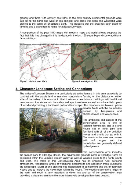
granary <strong>and</strong> three 19th century oast kilns. In the 19th century ornamental grounds were<br />
laid out to the north <strong>and</strong> west of this complex <strong>and</strong> some tree belts <strong>and</strong> woodl<strong>and</strong> were<br />
planted to the south on Shepherds Bank. This indicates that the area has been used for<br />
farming <strong>and</strong> a gr<strong>and</strong> family home for at least 600 years.<br />
A comparison of the post 1843 maps with modern maps <strong>and</strong> aerial photos supports the<br />
fact that little has changed in this l<strong>and</strong>scape in the last 150 years beyond some additional<br />
farm buildings.<br />
© © Crown copyright. All rights reserved. Canterbury City Council Licence No 100019614 (2004). Additional overlaid information is copyright of Canterbury City Council<br />
Figure3: Historic map 1843- Figure 4: Aerial photo 2003<br />
4. Character L<strong>and</strong>scape Setting <strong>and</strong> Connections<br />
The valley of Lampen Stream is a particularly attractive feature in this area especially by<br />
contrast with the arable l<strong>and</strong> in intensive monoculture farming on the plateaus on either<br />
side of the valley. It is unusual in that it retains a few historic buildings with traditional<br />
meadows on the slopes into the valley <strong>and</strong> specimen trees as well as substantial copses<br />
of woodl<strong>and</strong> providing a traditional parkl<strong>and</strong> l<strong>and</strong>scape. The meadows are broken up into<br />
smaller fields with the boundaries<br />
defined by hedgerows <strong>and</strong><br />
chestnut wood <strong>and</strong> wire fences.<br />
The ambiance <strong>and</strong> aspect of the<br />
conservation area is one of<br />
isolated farmsteads <strong>and</strong> a gr<strong>and</strong><br />
house set in rural park <strong>and</strong><br />
farml<strong>and</strong> with all of the activities<br />
noises <strong>and</strong> smells that go with it.<br />
The roads in the area are narrow<br />
with soft edges <strong>and</strong> the<br />
boundaries are generally defined<br />
by hedgerows.<br />
The conservation area includes<br />
the former park to Elbridge House, the ornamental grounds north of Elbridge Farm all<br />
contained within the Lampen Stream valley as well as wooded areas to the north, south<br />
<strong>and</strong> west. The whole of this Conservation Area has an unspoiled rural parkl<strong>and</strong><br />
atmosphere. Hedgerows, areas of woodl<strong>and</strong>, shelterbelts <strong>and</strong> specimen trees, punctuate<br />
the l<strong>and</strong>scape. Much of this planting was designated to compliment <strong>and</strong> set off Elbridge<br />
House <strong>and</strong> to improve the views from within the house. The woodl<strong>and</strong> along the ridges to<br />
the north <strong>and</strong> south is very important to views into <strong>and</strong> out of the conservation area<br />
providing a visual screen from the more intensively developed farml<strong>and</strong> beyond.<br />
7