JOINT PERMIT APPLICATION FORM - Utah Division of Water Rights
JOINT PERMIT APPLICATION FORM - Utah Division of Water Rights
JOINT PERMIT APPLICATION FORM - Utah Division of Water Rights
- No tags were found...

You also want an ePaper? Increase the reach of your titles
YUMPU automatically turns print PDFs into web optimized ePapers that Google loves.
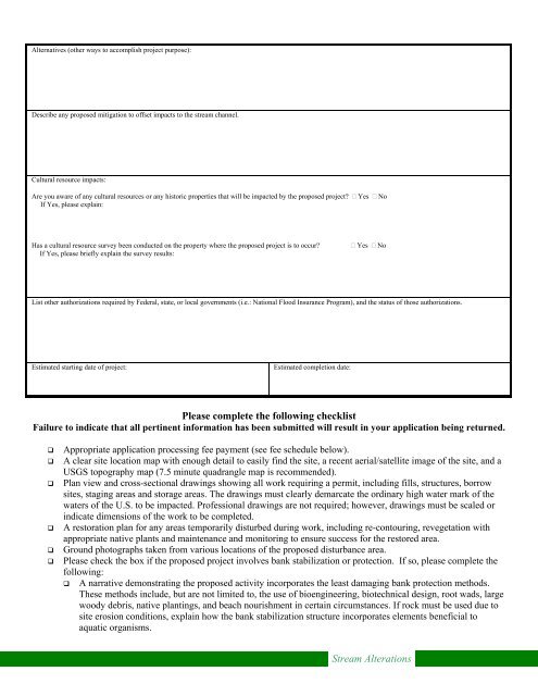
Alternatives (other ways to accomplish project purpose):<br />
Describe any proposed mitigation to <strong>of</strong>fset impacts to the stream channel.<br />
Cultural resource impacts:<br />
Are you aware <strong>of</strong> any cultural resources or any historic properties that will be impacted by the proposed project Yes No<br />
If Yes, please explain:<br />
Has a cultural resource survey been conducted on the property where the proposed project is to occur Yes No<br />
If Yes, please briefly explain the survey results:<br />
List other authorizations required by Federal, state, or local governments (i.e.: National Flood Insurance Program), and the status <strong>of</strong> those authorizations.<br />
Estimated starting date <strong>of</strong> project:<br />
Estimated completion date:<br />
Please complete the following checklist<br />
Failure to indicate that all pertinent information has been submitted will result in your application being returned.<br />
Appropriate application processing fee payment (see fee schedule below).<br />
A clear site location map with enough detail to easily find the site, a recent aerial/satellite image <strong>of</strong> the site, and a<br />
USGS topography map (7.5 minute quadrangle map is recommended).<br />
Plan view and cross-sectional drawings showing all work requiring a permit, including fills, structures, borrow<br />
sites, staging areas and storage areas. The drawings must clearly demarcate the ordinary high water mark <strong>of</strong> the<br />
waters <strong>of</strong> the U.S. to be impacted. Pr<strong>of</strong>essional drawings are not required; however, drawings must be scaled or<br />
indicate dimensions <strong>of</strong> the work to be completed.<br />
A restoration plan for any areas temporarily disturbed during work, including re-contouring, revegetation with<br />
appropriate native plants and maintenance and monitoring to ensure success for the restored area.<br />
Ground photographs taken from various locations <strong>of</strong> the proposed disturbance area.<br />
Please check the box if the proposed project involves bank stabilization or protection. If so, please complete the<br />
following:<br />
A narrative demonstrating the proposed activity incorporates the least damaging bank protection methods.<br />
These methods include, but are not limited to, the use <strong>of</strong> bioengineering, biotechnical design, root wads, large<br />
woody debris, native plantings, and beach nourishment in certain circumstances. If rock must be used due to<br />
site erosion conditions, explain how the bank stabilization structure incorporates elements beneficial to<br />
aquatic organisms.<br />
Stream Alterations


![Lynx avoidance [PDF] - Wisconsin Department of Natural Resources](https://img.yumpu.com/41279089/1/159x260/lynx-avoidance-pdf-wisconsin-department-of-natural-resources.jpg?quality=85)