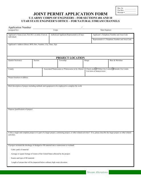
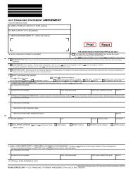
JOINT PERMIT APPLICATION FORM - Utah Division of Water Rights
JOINT PERMIT APPLICATION FORM - Utah Division of Water Rights
JOINT PERMIT APPLICATION FORM - Utah Division of Water Rights
- No tags were found...

Create successful ePaper yourself
Turn your PDF publications into a flip-book with our unique Google optimized e-Paper software.
<strong>JOINT</strong> <strong>PERMIT</strong> <strong>APPLICATION</strong> <strong>FORM</strong><br />
U.S ARMY CORPS OF ENGINEERS – FOR SECTIONS 404 AND 10<br />
UTAH STATE ENGINEER’S OFFICE – FOR NATURAL STREAM CHANNELS<br />
Rec. by ____________<br />
Fee Rec. ____________<br />
Receipt # ____________<br />
Application Number ___________________________________/____________________________________<br />
(assigned by): Corps State Engineer<br />
Applicant’s Name (Last, First M.I. or entity if not an<br />
individual)<br />
Authorized Applicant Representative (if any)<br />
Applicant’s Telephone Number and Area Code<br />
Representative’s Telephone Number and Area Code<br />
Applicant’s Address (Street, RFD, Box, Number, City, State, Zip)<br />
PROJECT LOCATION<br />
Quarter Section(s) Section Township Range Base & Meridian<br />
County Associated <strong>Water</strong>course or <strong>Water</strong>course to be Altered Check one: Within City Limits Outside City Limits<br />
List town or nearest town:<br />
Project location or address:<br />
Brief description <strong>of</strong> project including methods and equipment to be employed to complete the work:<br />
Purpose (justification) <strong>of</strong> project:<br />
Is this a single and complete project or is part <strong>of</strong> a larger project, continuing project, or other related activities If so, please describe the larger project or other related<br />
activities.<br />
If project included the discharge <strong>of</strong> dredged or fill material into a watercourse or wetland:<br />
Cubic yards <strong>of</strong> material:<br />
Acreage or square footage <strong>of</strong> waters <strong>of</strong> the United States affected by the project:<br />
Source and type <strong>of</strong> fill material:<br />
Length <strong>of</strong> stream that will be impacted below ordinary high water elevation:<br />
Stream Alterations
Alternatives (other ways to accomplish project purpose):<br />
Describe any proposed mitigation to <strong>of</strong>fset impacts to the stream channel.<br />
Cultural resource impacts:<br />
Are you aware <strong>of</strong> any cultural resources or any historic properties that will be impacted by the proposed project Yes No<br />
If Yes, please explain:<br />
Has a cultural resource survey been conducted on the property where the proposed project is to occur Yes No<br />
If Yes, please briefly explain the survey results:<br />
List other authorizations required by Federal, state, or local governments (i.e.: National Flood Insurance Program), and the status <strong>of</strong> those authorizations.<br />
Estimated starting date <strong>of</strong> project:<br />
Estimated completion date:<br />
Please complete the following checklist<br />
Failure to indicate that all pertinent information has been submitted will result in your application being returned.<br />
Appropriate application processing fee payment (see fee schedule below).<br />
A clear site location map with enough detail to easily find the site, a recent aerial/satellite image <strong>of</strong> the site, and a<br />
USGS topography map (7.5 minute quadrangle map is recommended).<br />
Plan view and cross-sectional drawings showing all work requiring a permit, including fills, structures, borrow<br />
sites, staging areas and storage areas. The drawings must clearly demarcate the ordinary high water mark <strong>of</strong> the<br />
waters <strong>of</strong> the U.S. to be impacted. Pr<strong>of</strong>essional drawings are not required; however, drawings must be scaled or<br />
indicate dimensions <strong>of</strong> the work to be completed.<br />
A restoration plan for any areas temporarily disturbed during work, including re-contouring, revegetation with<br />
appropriate native plants and maintenance and monitoring to ensure success for the restored area.<br />
Ground photographs taken from various locations <strong>of</strong> the proposed disturbance area.<br />
Please check the box if the proposed project involves bank stabilization or protection. If so, please complete the<br />
following:<br />
A narrative demonstrating the proposed activity incorporates the least damaging bank protection methods.<br />
These methods include, but are not limited to, the use <strong>of</strong> bioengineering, biotechnical design, root wads, large<br />
woody debris, native plantings, and beach nourishment in certain circumstances. If rock must be used due to<br />
site erosion conditions, explain how the bank stabilization structure incorporates elements beneficial to<br />
aquatic organisms.<br />
Stream Alterations
A description <strong>of</strong> current and expected post-activity sediment movement and deposition patterns in and near<br />
the activity area.<br />
A description <strong>of</strong> current and expected post-activity habitat conditions, including the presence <strong>of</strong> fish, wildlife<br />
and plant species in the activity area.<br />
An assessment <strong>of</strong> the likely impact the work would have on upstream, downstream and cross-stream<br />
properties (at a minimum the area assessed should extend from the nearest upstream bend to the nearest<br />
downstream bend <strong>of</strong> the watercourse). Specifically, discuss how the project will impact the following:<br />
Will the activity accelerate deposition or erosion<br />
Will impacts to sensitive species or habitats result from a change in suspended sediment load or turbidity<br />
Will the activity affect the diversity <strong>of</strong> the channel by eliminating in-stream habitat, meanders, or gravel<br />
bars<br />
Will the activity result in a shift in the main flow patterns<br />
A planting plan which involves the use <strong>of</strong> native riparian plants, unless the applicant demonstrates it is not<br />
appropriate or not practicable.<br />
Application is hereby made for a permit or permits to authorize the activities described herein. I certify that I am familiar with the information contained in the<br />
application, and that to the best <strong>of</strong> my knowledge and belief, such information is true, complete and accurate. I further certify that I possess the authority to undertake<br />
the proposed activities or am acting as the duly authorized agent <strong>of</strong> the applicant which is a (check one <strong>of</strong> the following) commercial , non-commercial , or<br />
governmental entity.<br />
Signature <strong>of</strong> Applicant_____________________________________________________________________Date:___________________________________________<br />
I hereby certify that_________________________________________________________________________________________is acting as my agent on this project.<br />
Agent’s address and telephone number: ______________________________________________________________________________________________________<br />
Filing Instructions<br />
Application supplements should be submitted on paper no larger than 11 x 17 inches or alternatively as PDF format<br />
electronic files. If more than one watercourse is to be altered as a result <strong>of</strong> the project, a separate application must be<br />
submitted for each watercourse. Application fees must be received by the <strong>Division</strong> <strong>of</strong> <strong>Water</strong> <strong>Rights</strong> at the time <strong>of</strong><br />
application submission and must be either hand delivered or submitted through standard mail. Checks should be made<br />
out to the <strong>Utah</strong> <strong>Division</strong> <strong>of</strong> <strong>Water</strong> <strong>Rights</strong>.<br />
Application Processing Fees<br />
Application fees are based on the type <strong>of</strong> entity applying for the proposed stream alteration project.<br />
Commercial Entities: $2000.00 per application processed.<br />
Non-Commercial Entities: $100.00 per application processed.<br />
Governmental Entities: $500.00 per application processed.<br />
Stream Alterations


![Lynx avoidance [PDF] - Wisconsin Department of Natural Resources](https://img.yumpu.com/41279089/1/159x260/lynx-avoidance-pdf-wisconsin-department-of-natural-resources.jpg?quality=85)