Southwest Florida - Hernando County
Southwest Florida - Hernando County
Southwest Florida - Hernando County
- No tags were found...

Create successful ePaper yourself
Turn your PDF publications into a flip-book with our unique Google optimized e-Paper software.
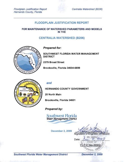
Floodplain Justification Reporl Centralia Watershed (8206)<br />
<strong>Hernando</strong> <strong>County</strong>, <strong>Florida</strong><br />
FLOODPLAIN JUSTIFICATION REPORT<br />
FOR MAINTENANCE OF WATERSHED PARAMETERS AND MODELS <br />
IN THE <br />
CENTRALIA WATERSHED (8206) <br />
Prepared for:<br />
SOUTHWEST FLORIDA WATER MANAGEMENT<br />
DISTRICT<br />
2379 Broad Street<br />
Brooksville, <strong>Florida</strong> 34604-6899<br />
and<br />
HERNANDO COUNTY GOVERNMENT<br />
20 North Main<br />
Brooksville, <strong>Florida</strong> 34601<br />
Prepared by:<br />
<strong>Southwest</strong> <strong>Florida</strong><br />
Water Management District<br />
December 2,2009<br />
<strong>Southwest</strong> <strong>Florida</strong> Water Management District December 2, 2009
2379 Broad Street, Brooksville, <strong>Florida</strong> 34604·6899<br />
<strong>Southwest</strong> <strong>Florida</strong><br />
(352) 796-7211 or 1·800423·1476 (FL only)<br />
Water Management District<br />
TOD only: 1·800·231·6103 (FL only)<br />
............~--~ <br />
On the Internet at WaterMatters.org<br />
An Equal<br />
Opporw"''Y<br />
E~<br />
Bartow Service Office Sarasota Service Office Tampa Service Office<br />
170 Century Boulevard 6750 Fruitville Road 7601 Highway 301 North<br />
Bartow, <strong>Florida</strong> 33830-7700 Sarasota, <strong>Florida</strong> 34240-9711 Tampa, <strong>Florida</strong> 33637-6759<br />
(863) 534·1448 or (941) 377·3722 or (813) 985-7481 or<br />
1-800-492·7862 (FL on ly) 1-800-320-3503 (FL only) 1-800-836-0797 (FL only)<br />
Todd Pressman<br />
Chair, Pinellas<br />
Ronald E. Oakley<br />
Vice Chair, Pasco<br />
Hugh M. Gramling<br />
Secretary, Hillsborough<br />
Sallie Par1l.s<br />
Treasurer, Pinellas<br />
Carlos Beruff<br />
Manatee<br />
Bryan K. Beswick<br />
DeSoto<br />
Jennifer E. Closshey<br />
HIllsborough<br />
Neil Combee<br />
Polk<br />
Albert G. Joerger<br />
Sarasota<br />
Maritza Rovira-Farino<br />
Hillsborough<br />
H. Paul Senft, Jr.<br />
Polk<br />
Douglas B. Tharp<br />
Sumter<br />
Judith C. Whitehead<br />
<strong>Hernando</strong><br />
David L. Moore<br />
Executive Director<br />
William S. Bilenky<br />
General Counsel<br />
PROFESSIONAL ENGINEER CERTIFICATION<br />
I hereby certify that I am a registered professional engineer in the State of <strong>Florida</strong><br />
practicing with the <strong>Southwest</strong> <strong>Florida</strong> Water Management District, a public corporation<br />
authorized to provide engineering analyses by the state of <strong>Florida</strong> Department of<br />
Professional Regulation, Board of Professional Engineers, and that I, or others under my<br />
direct supervision, have prepared the hydraulic and hydrology evaluations, findings,<br />
opinions, calculations, conclusions, inundation maps, electronic databases, and models<br />
inputs hereby represented in the Justification Report for the Centralia Watershed,<br />
<strong>Hernando</strong> <strong>County</strong>, <strong>Florida</strong>.<br />
This information was developed in accordance with the <strong>Southwest</strong> <strong>Florida</strong> Water<br />
Management District's Watershed Management Program Guidelines and Specifications<br />
(G&S). The G&S define the watershed parameters used to develop a computer model<br />
that simulates projected surface water levels. The model includes watershed and rainfall<br />
event simulation parameters such as a design rainfall event and associated antecedent<br />
moisture conditions. This information, including projected surface water levels, was<br />
reviewed for substantial conformance with G&S, through a public review and comment<br />
period, and refined based on comments. The parameters and models are revised<br />
periodically based upon updated information and issued Environmental Resource<br />
Permits (ERPs). The District will consider site specific details and other refinements<br />
during the regulatory review process to revise model parameters and results. Therefore,<br />
the District cannot guarantee its completeness and shall not be liable for any damages<br />
suffered as a result of using this information. Those interested in using this information<br />
should contact the District for the current version of a model and results for a specific<br />
watershed . ERP applicants are encouraged to schedule a pre-application meeting(s)<br />
with the District's Regulatory staff to discuss the use of any watershed study/model in a<br />
subsequent ERP application.<br />
If you have questions, please contact the <strong>Southwest</strong> <strong>Florida</strong> Water Management<br />
District's Engineering Section at 352-796-7211 ext. 4232.<br />
<strong>Southwest</strong> <strong>Florida</strong> Water Management District<br />
Company Name<br />
Harry C. Downing<br />
Name<br />
, .<br />
FL P,E. ~~ 35'i02:<br />
",' e\<br />
. 001\'~l<br />
-.
Floodplain Justification Report<br />
<strong>Hernando</strong> <strong>County</strong>, <strong>Florida</strong><br />
Centralia Watershed (B206)<br />
_____________________________________________________________________________<br />
TABLE OF CONTENTS<br />
1.0 INTRODUCTION ___________________________________________ 1<br />
2.0 GUIDELINES & SPECIFICATIONS _____________________________ 1<br />
3.0 WATERSHED DESCRIPTION _________________________________ 1<br />
4.0 FLOODPLAIN MODEL DEVELOPMENT METHODOLOGY _________ 2<br />
5.0 VERIFICATION & VALIDATION DATA _________________________ 12<br />
6.0 MODELED FLOODPLAINS __________________________________ 14<br />
7.0 FLOODPLAIN JUSTIFICATION _______________________________ 15<br />
8.0 PUBLIC MEETING _________________________________________ 16<br />
9.0 CONCLUSION ____________________________________________ 16<br />
10.0 REFERENCES _____________________________________________ 16<br />
ATTACHMENTS<br />
FIGURES<br />
TABLES<br />
EXHIBITS<br />
Figure 1 - Location Map<br />
Figure 2 - Existing FEMA Floodplain<br />
Figure 3 - 1960 Potentiometric Surface Above Land Surface<br />
Figure 4 - Western Region Floodplain Comparisons<br />
Figure 5 - Corresponding Land Surface and 1960 Potentiometric Surface<br />
Figure 6 - Evaluation Areas for Multi-Day<br />
Figure 7 - Projected 1- and 5-day Elevation Comparison<br />
Figure 8 - Two-Sink Area Investigation<br />
Figure 9 - Catchments Selected for Multi-Day Assignment<br />
Figure 10 - Well Levels<br />
Figure 11 - Withlacoochee River and Weeki Wachee Well Levels<br />
Figure 12 - 1960 Potentiometric Surface Overlain On To 1970 Aerial Photos<br />
Figure 13 - Centralia Romp Well with Historic Contours<br />
Figure 14 - Pasco 16 Well<br />
Figure 15 - Modeled 100-Year/24-Hour Floodplain<br />
Table 1 - Floodplain Justification Summary<br />
Exhibit – Model Map<br />
________________________________________________________________<br />
<strong>Southwest</strong> <strong>Florida</strong> Water Management District December 2, 2009
Floodplain Justification Report<br />
<strong>Hernando</strong> <strong>County</strong>, <strong>Florida</strong><br />
Centralia Watershed (B206)<br />
_____________________________________________________________________________<br />
1.0 INTRODUCTION<br />
The purpose of this Floodplain Justification Report is to provide information regarding the reasonableness<br />
of the floodplain elevations simulated as part of the Centralia Watershed Management Plan Efforts. This<br />
effort is an update of the preliminary floodplains generated during previous watershed management<br />
efforts in 2006. After review and acceptance of this effort, the floodplain information will be used as part<br />
of the map modernization process in updating flood hazard areas for flood insurance mapping (FIRM)<br />
purposes.<br />
Engineering staff of the <strong>Southwest</strong> <strong>Florida</strong> Water Management District (District) and subcontractors ECT,<br />
Inc. conducted this watershed management effort to be used by the District and <strong>Hernando</strong> <strong>County</strong>,<br />
<strong>Florida</strong> as part of the floodplain mapping modernization process for <strong>Hernando</strong> <strong>County</strong>. This justification<br />
report was prepared by the District.<br />
A watershed model and Geographic Information System (ESRI ArcMap TM ) database is provided along<br />
with the report. Additional information used to support the development of the floodplains is provided in<br />
electronic deliverables. An overview of the methodology and results is provided for general reference<br />
only. More detailed information is provided in the enclosed electronic databases.<br />
This Floodplain Justification Report reflects comments made during internal reviews conducted in August<br />
2008, March 2009, and June 2009. Responses and modifications to the modeled floodplains are<br />
provided in a spreadsheet related Geodatabase located under the “COMMENT” subdirectory of the<br />
project submittal.<br />
2.0 GUIDELINES AND SPECIFICATIONS<br />
The watershed management activities were conducted in general accordance with the following<br />
documents:<br />
SWFWMD Guidelines & Specifications (G&S), current version with addendums<br />
FEMA Guidelines & Specifications for Flood Mapping Partners, 2003<br />
3.0 WATERSHED DESCRIPTION<br />
The Centralia Watershed is approximately 25.2 square miles (16,105 acres) in size and is located in<br />
north-west <strong>Hernando</strong> <strong>County</strong> (Figure 1). General characteristics of the watershed are summarized<br />
below:<br />
<br />
<br />
Topography – the terrain slopes from approximately 200 feet NAVD 88 beginning with<br />
Bailey Hill located in the southeast portion of the watershed and gradually declining to<br />
elevations less than 10-feet at the Gulf coastal areas located near US 19. The watershed<br />
is characterized by numerous depressions created by dissolution and collapsing of the<br />
underlying limestone that become more characteristic of wetlands near the coast. A<br />
natural channel exists in the eastern portion of the watershed, but gradually disappears<br />
as it enters the more karst areas of the watershed.<br />
Water Bodies – no significant lakes exist within the watershed. Sinks, wetlands, and<br />
predominantly dry depressions are pervasive throughout the watershed. A creek (Dry<br />
Creek) in the southeastern part of the watershed conveys runoff from Bailey Hill. A<br />
remnant creek still exists in the northeastern portion of the watershed that conveyed<br />
runoff from an area that has now been mined for limerock.<br />
________________________________________________________________<br />
<strong>Southwest</strong> <strong>Florida</strong> Water Management District December 2, 2009
Floodplain Justification Report<br />
Centralia Watershed (B206)<br />
<strong>Hernando</strong> <strong>County</strong>, <strong>Florida</strong> Page 2 of 31<br />
_____________________________________________________________________________<br />
Soils – deep sandy soils characterize (predominantly Candler) approximately 60-70<br />
percent of the watershed. Candler soils are characterized as hydrologic „A‟ soils which<br />
have good infiltration and very low runoff potential. The upper horizon of this soil has a<br />
permeability of 70 feet per day on average, based on the Soil Survey Geodatabase<br />
(SSURGO). A lower horizon below 4 feet has a permeability of 26 feet per day. Water<br />
tables within these soils are 6-8 feet or greater below the surface. With deep<br />
characteristic water tables these soils can infiltrate significant volumes of rainfall even at<br />
very high intensities.<br />
<br />
<br />
Landuse – the watershed is predominantly rural with a large portion of the watershed<br />
located east of U.S. 19 developed into single family residential lots that are about 0.5<br />
acres in size, but can range up to 10 acres. Approximately 25% of the lots are occupied.<br />
Limerock pits and spoil area characterizes the northeast portion of the watershed while<br />
the southeast portion of the watershed remains in its natural condition. The portion of the<br />
watershed located west of US 19 is predominately in its natural state.<br />
Existing Floodplains - a large portion of the watershed has no existing Federal<br />
Emergency Management Agency (FEMA) floodplain designations (Figure 2.). FEMA<br />
delineations total approximately 237 acres of which most are characterized as Zone A. A<br />
few AE zones exist along the western boundary of the watershed. Delineations appear to<br />
have been based on 5-foot contour map accuracy or USGS quadrangle resolution since<br />
floodplain boundaries cross several contours from the more accurate LiDAR derived<br />
topography.<br />
4.0 FLOODPLAIN MODEL DEVELOPMENT METHODOLOGY<br />
Compilation of acquired data, reports and historical data elements were relied upon to develop what is<br />
considered reasonable floodplain elevations throughout the watershed. Watershed management<br />
activities conducted in support of the generation of the floodplains included the following:<br />
<br />
Digital Topographic Information<br />
o<br />
Terrain for the watershed was based on LiDAR collected in January 2007 for <strong>Hernando</strong><br />
<strong>County</strong> areas having a 95% vertical accuracy of ±0.5 foot for ground that is readily<br />
visible. The acquired LiDAR data at 6-foot post spacing was converted to a Digital<br />
Elevation Model (DEM) of 5-foot spacing for processing catchment information.<br />
Adjustments were made to the terrain in basins BS1400, BS1500, and BS1540 to<br />
account for a conveyance system that was located during the public input process.<br />
Terrain elevation data is in NAVD 88.<br />
<br />
Watershed Evaluation<br />
o<br />
o<br />
Generic watershed feature collection, evaluation, and assembly into datasets from<br />
existing sources. Existing data sources from the previous study and ERP construction<br />
plans were used to identify watershed features, and populate the Geographic Watershed<br />
Information System. ERP data and construction plans used within the watershed<br />
evaluation are documented in the Technical Support Data Notebook (TSDN).<br />
In some areas of the watershed the available terrain and construction details were not<br />
sufficient to develop the connectivity of the watershed. In such cases, field<br />
reconnaissance was performed to identify conveyance patterns and contributing areas to<br />
key storage areas, especially along the Suncoast Corridor that traverses the watershed.<br />
In some instances Geospatial data were collected to verify (xyz) information of key<br />
structure elements that appeared suspect. Limited survey accuracy techniques, GPS<br />
________________________________________________________________<br />
<strong>Southwest</strong> <strong>Florida</strong> Water Management District December 2, 2009
Floodplain Justification Report<br />
Centralia Watershed (B206)<br />
<strong>Hernando</strong> <strong>County</strong>, <strong>Florida</strong> Page 3 of 31<br />
_____________________________________________________________________________<br />
and relative elevations to roadways crowns, depth of cover, etc. were used to meet the<br />
time constraints of the project schedule. All data were converted to NAVD 88.<br />
o<br />
Watershed boundaries, catchment boundaries, surface storage, and conveyance<br />
features of interest were developed based on the 2007 topographical data supplemented<br />
with conveyance feature information. Centralia watershed boundaries contiguous to<br />
other watersheds were matched to prevent overlaps and gaps as much as possible.<br />
o<br />
From use of the topographical data, closed conveyance features locations were<br />
anticipated and inventoried for pipes and inlets. When such conveyance systems did not<br />
exist, open conveyance systems such as channels, and overland weirs were used to<br />
connect catchments throughout the watershed.<br />
<br />
Watershed Management Plan<br />
o<br />
o<br />
o<br />
Under this element of the plan, generic and specific hydraulic feature information were<br />
processed into GIS feature layers and tables in support of the computer simulation<br />
model.<br />
Watershed feature information from GIS and other table information were translated into<br />
compatible input data for the ICPR Version 3.10 PercPack computer model to<br />
characterize the hydrology and hydraulic features of the watershed. The FEMA approved<br />
ICPR TM model version 3 for analyzing the watersheds response to design and historic<br />
storm events.<br />
Storm Events modeled:<br />
• The 100 year – 24-hour, 3-day, 5-day, 7-day durations and 500 year – 24-hour<br />
duration events using Technical Paper 49 (Weather Bureau, 1964) and the<br />
SWFWMD G&S designated rainfalls depths of 12.5, 14.8, 16.8, 18.0 inches for<br />
the 100-year events and 16.0 inches for the 500-year event, respectively were<br />
modeled. The 24-hour and 5-day distributions were based on the SWFWMD<br />
G&S. The <strong>Florida</strong> Type II Modified rainfall distribution was used for the one-day<br />
events according to the SWFWMD G&S. The multi-day events were distributed<br />
using the FDOT distributions as provided with ICPR, while the 5-day distribution<br />
was based on the Bear Creek Study provided in the SWFWMD G&S. The 24-hr,<br />
<strong>Florida</strong> Type II Modified distribution includes short-term peak intensities in order<br />
to simulate peak runoff rates that occur for small contributing areas during<br />
intense thunder storms.<br />
• Twenty-four and multi-day (5-day) rainfall events were simulated for the<br />
watershed. For the large relief and low permeable soils in the eastern portion of<br />
the watershed, the 24-hour storm generated the highest peak stages. For the<br />
western portion of the watershed, the multi-day generated the highest stages due<br />
to the filling of the available depression and soil storage. It was decided to use<br />
the 24-hour storm event for determining the resultant floodplains for the eastern<br />
portion of the watershed since there was no compelling evidence for the multiday<br />
event floodplains. For the western portion of the watershed model results,<br />
available historic and more recent high water marks, and potentiometric surface<br />
information generated in 1960 provided compelling evidence for the multi-day<br />
events.<br />
• Multi-day Justification - As part of the Peer Review, it was indicated that that a<br />
multi-day rainfall event would provide a better projection of the floodplain in<br />
certain areas of the Centralia watershed rather than the 24-hour event. Typically,<br />
________________________________________________________________<br />
<strong>Southwest</strong> <strong>Florida</strong> Water Management District December 2, 2009
Floodplain Justification Report<br />
Centralia Watershed (B206)<br />
<strong>Hernando</strong> <strong>County</strong>, <strong>Florida</strong> Page 4 of 31<br />
_____________________________________________________________________________<br />
the 24-hour distributed with the Type II Modified SCS distribution addresses flood<br />
projections associated with peak responsive areas, whereas multi-day events<br />
address volume responsive areas. The Centralia watershed exhibits both<br />
characteristics. Initially, it was theorized that the starting water table or seasonal<br />
high elevations would characterize the volume sensitive areas, but modeled 24-<br />
hour flood projections in the western portion of the watershed still exhibited<br />
slightly lower elevations than might be expected in some areas. The 24-hour<br />
projections were sufficient for the eastern portion of the watershed based on high<br />
water marks that were available and the modeling results.<br />
The Centralia watershed is dominated by unconfined to semi-confined aquifer<br />
system that affects the surface level response to rainfall. The 2004<br />
potentiometric surface in concert with iterative simulation adjustments were used<br />
to develop initial water table conditions throughout the watershed since this<br />
period represented the most recent magnitude rainfall whereby documented<br />
flood elevations (high water marks) could be readily obtained. High water marks<br />
from collected data and aerial photos were used to determine the<br />
reasonableness of the results. Historical aerial photos provided the visual signs<br />
(tree-lines, wet prairies, etc.) regarding reasonableness of floodplains primarily in<br />
the western portion of the watershed. Aerial photos showing tree-lines from<br />
1944, 1951, and 1970, and the more recent photography of 2004 and 2005 were<br />
used to make inferences about historical flooding.<br />
In general it appears that 1960 may have generated the highest sustained flood<br />
elevations as evidence by the tree die-off manifested in the 1970 aerials and the<br />
now observed re-growth in the 2000 vintage series photography. The best<br />
verification came from the high water mark information from the recent<br />
hurricanes of 2004 and comparing those elevations to simulated flood elevations.<br />
The 2004 high water marks were used to verify the parameterization of the model<br />
along with the ROMP monitoring well data for the surficial and <strong>Florida</strong>n<br />
monitoring water level data. The 1960 tree-line or clear zone and the 1960<br />
potentiometric surface provided information on the near upper limit of most likely<br />
flooding. It should be noted that specific elevations for historical high water<br />
levels are sparse. The intersection of the 1960 potentiometric surface with land<br />
surface elevations provided better spatial inferences than can be achieved by the<br />
high water mark information alone.<br />
Comparison of the 1960 potentiometric surface intersection with land surface and<br />
the 1970 photos generally indicate that the multi-day events provide better<br />
projections of the 100-year event particularly in the western portion of the<br />
watershed. In a majority of the basins, the multi-day events are contained within<br />
the 1960 potentiometric intersected surface or polygon areas (Figure 3).<br />
Simulated floodplains trended smaller than the 1960 potentiometric surface area<br />
in the southwest portion of the watershed (Figure 4). It may be that the<br />
extensive ditching and draining of this area has had an impact on the<br />
potentiometric surface and flood elevations. There has also been a significant<br />
reduction in the contributing area in a subwatershed located just upstream of this<br />
area. In any event, it is recognized that there is compelling evidence that flood<br />
projections within these areas are better reflected by the multi-day event.<br />
The area where the multi-day better represents historical flood signatures<br />
corresponds to areas where land surface elevations are 25-feet or less (Figure<br />
5). These are the only areas that the multi-day can be applied provided the<br />
following criteria are met. The use of multi-day results will be used in areas<br />
where land elevations within a basin are typically 25-feet or less and the multiday<br />
floodplain is within the foot print of the 1960 intersected pot surface with land<br />
________________________________________________________________<br />
<strong>Southwest</strong> <strong>Florida</strong> Water Management District December 2, 2009
Floodplain Justification Report<br />
Centralia Watershed (B206)<br />
<strong>Hernando</strong> <strong>County</strong>, <strong>Florida</strong> Page 5 of 31<br />
_____________________________________________________________________________<br />
surface. If the one-day or the multi-day (5-day) event produces a floodplain<br />
greater than the 1960 pot surface, the one-day will be used in that basin. There<br />
is one exception area that is identified in Figure 7. Mining areas where earthen<br />
material has been excavated down to the water table is also apparent in the map.<br />
These areas will be excluded from floodplain mapping.<br />
Simulations for 1 thru 7-day durations were conducted to determine the<br />
watershed‟s response to single and multi-day events and are included in a<br />
geodatabase table “ICPR_Node_Results.” Based on the simulations, 594<br />
junctions out of 932 non-boundary junctions exhibited a higher or same peak<br />
response with the 1-day (within ± 0.01 feet) as compare to the multi-day rainfall<br />
indicating peak sensitivity. None of the junctions exhibited peak elevations with<br />
the 3-day rainfall. One hundred seventy-two (172) junctions exhibited peak<br />
elevations with the 5-day rainfall. Of the 177 junctions that exhibited peak<br />
elevations with the 7-day rainfall, 156 were less than 0.5 feet higher than the 5-<br />
day rainfall and 108 of those were within 0.1 feet or less. Only 21 had projected<br />
peaks greater than 0.5 feet. To maintain consistency throughout the watershed,<br />
it is recommended that the either the one-day or 5-day be used. The one-day<br />
will be used wherever land surface elevations within a basin are greater than 25-<br />
feet which occur primarily in the eastern portion of the watershed. There is no<br />
compelling information to indicate that the multi-day should be imposed in this<br />
area. Mining areas will be excluded from floodplain assignment. In the western<br />
portion of the watershed where basins have land surface elevations 25-feet or<br />
less, the most appropriate rainfall duration will be used based on the compelling<br />
evidence. In this case, if the multi-day is higher than the 1-day and the multi-day<br />
floodplains are within the 1960 pot surface intersect with the land surface, then<br />
the multi-day (5-day for consistency) will be used. Otherwise, if either the 1-day<br />
or 5-day exceeds the 1960 pot surface the 1-day results will be used. Figure 6<br />
indicates the basins where the multi-day was evaluated.<br />
Figure 7 represents the results of the 1-day and 5-day comparisons. Green dots<br />
represent the junctions with flood elevations that are higher for the 1-day rainfall<br />
duration or the 1-day is within 0.01-foot of the 5-day duration rainfall. Yellow dots<br />
represent where the 5-day is less than one-half foot higher than the 1-day, while<br />
the red dots indicate where the 5-day is greater than one-half foot. Since the 1-<br />
day event is in agreement with high water marks observed in the eastern portion<br />
of the watershed the multi-day will not be applied in that area.<br />
On July 9, 2009, a field investigation was conducted in an area where significant<br />
differences existed between the one-day and multi-day events (Figure 8). This<br />
area is located in the southwest central portion of the watershed, and represents<br />
the terminal or last receiving area of runoff from a creek system. A rather large<br />
sink resides (Two-Sinks) in this location which is considered a volume sensitive<br />
area. High water marks (lichen lines) were very apparent and were higher than<br />
what the aerial photos of 2005 would lead one to expect. Preliminary review of<br />
collected high water elevations were between 27-28 feet, which is higher than the<br />
1960 potentiometric surface for the same area. This suggests that more than<br />
just local runoff is reaching the area from upstream portions of the watershed,<br />
and it is being infiltrated at such at rate that tree mortality is minimal. The recent<br />
observation of past flooding in this area provides compelling evidence for flood<br />
projections using a multi-day rainfall event, since the resultant flooding from the<br />
one-day duration is less than the recent flooding for the Two-Sinks area.<br />
The Frances rainfall simulation in concert with the high water marks collected<br />
were used to adjust the infiltration capacity in this area. A culvert of a specific<br />
diameter, length, and roughness factor was used to simulate the additional<br />
________________________________________________________________<br />
<strong>Southwest</strong> <strong>Florida</strong> Water Management District December 2, 2009
Floodplain Justification Report<br />
Centralia Watershed (B206)<br />
<strong>Hernando</strong> <strong>County</strong>, <strong>Florida</strong> Page 6 of 31<br />
_____________________________________________________________________________<br />
infiltration capacity of the sink area not reflected by percolation. This area will be<br />
included in multi-day response area along with adjacent basins that area<br />
affected.<br />
The multi-day (5-day) will be applied only in the areas indicated in Figure 9<br />
based on the multi-day evaluation for each of the basins which includes the Two-<br />
Sink area previously mention. One hundred five basins out of 230 selected for<br />
evaluation had the multi-day rainfall applied for determining the 100-year flood<br />
elevations. The total number of basins in the watershed is 877. The darker<br />
purple color is the location of where the multi-day was applied. The lighter purple<br />
color are areas that were evaluated for multi-day assignment, but did not meet<br />
the criteria for compelling information (i.e., either the one-day or the 5-day<br />
exceeded the 1960 intersect area). The mining area located in the eastern<br />
portion of the watershed will be excluded from the floodplain mapping.<br />
• Doppler (OneRain) temporally and spatially derived rainfall for Hurricane Frances<br />
from September 4 to September 9, 2004 (96 hrs.) was applied to the watershed<br />
for verification of the model parameters. Rainfall during this period ranged from<br />
10.8 to 15.5 inches with an average of 13.4 inches.<br />
o<br />
The ICPR Model included the following elements:<br />
• 877 subbasins (delineated based on the DTM)<br />
• 948 active nodes representing storage in the form of ponds and depressions,<br />
channel junctions, boundaries, and receiving groundwater.<br />
• 3266 active reaches of which 1084 had simulated flow -<br />
<br />
<br />
<br />
<br />
<br />
123 Channels (all flowing) - representing 11.4 miles<br />
230 Pipes (200 with flow) – representing primarily conveyance<br />
connection through roadways<br />
2463 Weirs (342 with flow) - representing fixed structures, and natural<br />
and road overflows<br />
13 Drop structures (11 with flow) - mainly associated with SMAs<br />
455 (445 Percolation links active) – representing ground water infiltration<br />
within streams and depressions<br />
o<br />
Model Parameterization was based on the following criteria:<br />
• Hydrologic Parameterization<br />
Catchment delineation was based on the following watershed<br />
characterization:<br />
o<br />
o<br />
All significant depression storage areas were parameterized<br />
Channel segments or reaches identified based on a maximum<br />
length of 500 feet, change in grade and hydraulic characteristics,<br />
and confluences.<br />
________________________________________________________________<br />
<strong>Southwest</strong> <strong>Florida</strong> Water Management District December 2, 2009
Floodplain Justification Report<br />
Centralia Watershed (B206)<br />
<strong>Hernando</strong> <strong>County</strong>, <strong>Florida</strong> Page 7 of 31<br />
_____________________________________________________________________________<br />
o DRAs identified through ERPs, topographic information, and field<br />
investigation<br />
o<br />
Complex conveyance systems to DRAs were simplified<br />
(especially along the Suncoast Parkway where multiple inlets<br />
within the median were identified)<br />
<br />
Green-Ampt method used in ICPR Model for generating rainfall excess<br />
o<br />
Soil parameters were provided by the SWFWMD in the form of<br />
GIS layer information and look-up tables and applied in<br />
accordance with the procedures discussed in the draft<br />
document, "Determination of Green-Ampt Parameters for<br />
Hydrology Computations In ICPR, SWFWMD August 2008."<br />
Sources for the data include the IFAS Soil Characterization Data,<br />
and the NRCS Soil Survey GeoDatabase. These parameters<br />
were used in the initial simulations and adjusted based on the<br />
comparison of observed vs. simulated results. These<br />
parameters were converted to the appropriate units and<br />
representation for use in the ICPR model. Parameters include:<br />
• Hydraulic Conductivity (SSURGO) – with a factor of onehalf<br />
applied to the specified value. The resultant value is<br />
in agreement with the reported ERP values particularly<br />
for the Candler Soils.<br />
• Depth to the Water Table (Seasonal High) – SSURGO<br />
values used for initial simulations with verification based<br />
on the September 2004 potentiometric surface map.<br />
Other data was used as this typically represents the<br />
initial conditions for modeling. In some instances the<br />
seasonal high is above the ground surface.<br />
• Soil Storage and porosity (IFAS Database and table<br />
provided by Rawls and Brakensiek, respectively). Soil<br />
storage is based on the IFAS Characterization data with<br />
an assumed depth to the water table and the soil at field<br />
capacity.<br />
• Effective Porosity = 0.90 x soil porosity.<br />
• ICPR Cutoff Depth is ICPRs representation of the<br />
location of the water table below the ground surface and<br />
is equal to (soil storage) / (effective porosity).<br />
• Suction Head = initial suction head of the soil based on<br />
literature values. It was found that the soil infiltrated<br />
volume is relatively insensitive to this parameter.<br />
o<br />
o<br />
Soil parameters were calculated individually for each subbasin<br />
using GIS processing tools and SAS.<br />
Percolation locations were based on an initial ICPR model run<br />
without percolation to identify where floodplains occurred in deep<br />
water table areas. After the percolation locations were identified,<br />
an iterative process was initiated to determine the percolation<br />
________________________________________________________________<br />
<strong>Southwest</strong> <strong>Florida</strong> Water Management District December 2, 2009
Floodplain Justification Report<br />
Centralia Watershed (B206)<br />
<strong>Hernando</strong> <strong>County</strong>, <strong>Florida</strong> Page 8 of 31<br />
_____________________________________________________________________________<br />
area for each location. The accepted percolation areas were<br />
then included in the basin hydrology as impervious areas.<br />
<br />
Impervious and Directly Connected Impervious Area Determination<br />
o<br />
Impervious area determination of the watershed was based on<br />
the processing of <strong>County</strong> Tax Assessor information and paved<br />
areas. Percent impervious area on a lot-by-lot basis was<br />
determined for <strong>Hernando</strong> <strong>County</strong> and then applied to the<br />
watershed. Directly Connected Impervious Areas (DCIA)<br />
percentages were calculated using equations derived from<br />
studies throughout the United States. The percent DCIA was<br />
calculated from the impervious areas and type. It was decided to<br />
use this method rather than build upon the FDOT fluccscode.<br />
DCIA percentages for the percolation areas were set to 100 to<br />
turn-off the Green-Ampt infiltration calculations and just use the<br />
percolation component of the model.<br />
<br />
<br />
Time of Concentration (Tc) based on the determination of the longest<br />
flow path for each catchment using GIS tools and the TR-55<br />
methodology. The flow paths were intersected with the District's<br />
Landuse layer to determine whether paved or unpaved areas were<br />
encountered.<br />
The unit hydrograph method was applied to the time series rainfall<br />
excess to simulate runoff from the individual catchments. A 256 peak<br />
factor unit hydrograph was used per the G&S. A 256 peak or shape<br />
factor represents gently sloping terrains.<br />
• Hydraulic Parameterization<br />
<br />
<br />
<br />
Storage representation for depressions at ICPR junctions was based on<br />
the DTM of the watershed and extracted using the ESRI ArcHydro tools<br />
at specified elevation intervals.<br />
Channel storage is directly accounted for in the ICPR model during the<br />
routing process based on cross section data. Junction storage was not<br />
applied to catchments that had channel conveyance features other than<br />
some minor storage to help maintain model stability.<br />
Irregular cross-sections were determined from the DTM and the LiDAR<br />
data of the watershed.<br />
o<br />
Cross-sections for overland flow weirs were based on the<br />
intersection of DTM and shared catchment boundaries, and the<br />
use of the ET-GEOWIZARD to extract the sequenced xyz points.<br />
SAS Loess smoothing techniques were applied to both the xy<br />
and z data to reduce the number of data points used to represent<br />
the cross-section. Smoothing of the xy data was necessary due<br />
to the artifact of using a DEM grid. Weir lengths were more<br />
correctly estimated with the application of the smoothing.<br />
Lengths were typically 20-30% shorter than representation from<br />
the DEM grid with artifact kinks.<br />
________________________________________________________________<br />
<strong>Southwest</strong> <strong>Florida</strong> Water Management District December 2, 2009
Floodplain Justification Report<br />
Centralia Watershed (B206)<br />
<strong>Hernando</strong> <strong>County</strong>, <strong>Florida</strong> Page 9 of 31<br />
_____________________________________________________________________________<br />
o Cross-sections for the channels were extracted directly from the<br />
LiDAR data using the LP-360 tool with xyz data provided every<br />
foot. Only smoothing of the z or elevation data was required<br />
because channel cross sections were represented by straight<br />
line segments.<br />
<br />
Culvert Inverts<br />
o<br />
Based on survey data, as-build-plans, construction plans, and<br />
estimated from the DEM with cover requirements when conflicts<br />
arose or no other data was available.<br />
<br />
Outfalls Along Watershed Boundaries<br />
o<br />
o<br />
Most outfalls for the watershed occurred along the western<br />
coastal boundary and were represented as overland flow weirs<br />
with no tailwater.<br />
One overflow into the Tooke Lake watershed occurred through a<br />
small culvert. Overflows into contiguous areas did not appear to<br />
be interactive so no time series elevations or tailwater interaction<br />
was considered.<br />
• Junction and Water Table Initial Conditions Evaluations<br />
<br />
Information Summary<br />
o<br />
o<br />
o<br />
o<br />
o<br />
o<br />
o<br />
o<br />
SSURGO depths to water table converted to elevations using the<br />
DEM and raster calculations<br />
September 2004 potentiometric surface map<br />
October 1960 potentiometric surface map (USGS Report)<br />
High water information from FDOT construction plans<br />
Limited Surficial Well Data<br />
Limited Geotechnical data to DRAs<br />
High water signatures based on review of 1970 aerial black &<br />
white photos<br />
Vegetative boundaries tree lines and wetlands used as indicators<br />
of water table conditions<br />
<br />
The 2004 potentiometric surface corrected to represent the surficial<br />
aquifer levels was used for the modeled initial stage for 100-year flood<br />
level projections This entailed the addition of 4.5 feet to the 2004<br />
surface. The resultant elevations were compared to the USGS<br />
measured October 1960 potentiometric surface after hurricane Donna in<br />
September of 1960. The 1960 surface was still significantly higher than<br />
the 2004 corrected surface. The corrected initial condition only affects<br />
the western third of the watershed where above or near surface water<br />
________________________________________________________________<br />
<strong>Southwest</strong> <strong>Florida</strong> Water Management District December 2, 2009
Floodplain Justification Report<br />
Centralia Watershed (B206)<br />
<strong>Hernando</strong> <strong>County</strong>, <strong>Florida</strong> Page 10 of 31<br />
_____________________________________________________________________________<br />
table conditions exists. It is not a factor for the remaining portions of the<br />
watershed due to the relative large depths to the potentiometric surface<br />
or water table.<br />
<br />
<br />
For dry depression areas where no wetlands were observed and<br />
significant depths to the water table were projected, the low elevation of<br />
the DTM was used for initial conditions. For the channels the crosssection<br />
low points were used for the starting elevation due to the large<br />
depths to the water table and the lack of any significant sustained base<br />
flow conditions in the creeks. Depths to the water table were determined<br />
by subtracting the water table elevations from the land surface.<br />
Initial Junction Water surface elevations were adjusted to low point<br />
overflows or slightly below when indicated water tables were higher.<br />
These overflows and adjustments were made through the modeling<br />
process by turning the runoff and percolation off and observing where<br />
flow was occurring.<br />
• Use of Channel versus Overland Weir<br />
<br />
<br />
Channels were used when the DTM clearly indicated a defined water<br />
course.<br />
Irregular weirs were used to represent connectivity between depressions<br />
with significant ridges with no observed channel course.<br />
• Percolation as an Outfall<br />
<br />
<br />
Percolation Areas were used in channels and depressions where<br />
hydrologic „A‟ type soils were prevalent and where the water table was<br />
one-foot or greater below the surface or a DRA existed.<br />
Percolation was not included where:<br />
o<br />
o<br />
Shallow or above ground water tables were projected.<br />
Soils groups were not hydrologic „A‟ soils.<br />
<br />
Percolation in creek channels that flowed through characteristic<br />
hydrologic „A‟ soil areas were included due to the observed<br />
geomorphology (i.e., the channels ended internally within the watershed<br />
indicating significant infiltration along its path).<br />
o<br />
Boundary conditions were set up to allow flow from the watershed<br />
• Most overflows from catchments along the outer watershed boundary were set<br />
up automatically even if they would not flow. The same process was followed for<br />
internal overflows between catchments to prevent "glass walls."<br />
• Where boundary overflows would affect other modeled watersheds, resultant<br />
flow hydrographs were furnished to the respective project manager. Due to the<br />
relative small flow rates, no consideration for full interaction was considered.<br />
________________________________________________________________<br />
<strong>Southwest</strong> <strong>Florida</strong> Water Management District December 2, 2009
Floodplain Justification Report<br />
Centralia Watershed (B206)<br />
<strong>Hernando</strong> <strong>County</strong>, <strong>Florida</strong> Page 11 of 31<br />
_____________________________________________________________________________<br />
o Floodplain Analysis using ICPR model results and GIS mapping methods<br />
• Floodplains in depressions were delineated by projecting model stage results<br />
onto the watershed DEM using the "Cut and Fill" tool provide with ArcInfo TM .<br />
The resultant areas were considered to be inundated by the 100-year flooding<br />
and have a base flood elevation (BFE) corresponding to a typical Zone AE<br />
designation used by FEMA Federal Insurance Rate Maps (FIRMS).<br />
• Sloping floodplains along channel features were delineated using contours and<br />
inundation levels from the cross-sections. Since cross-sections are located at<br />
model junctions, the resultant floodplain elevation was applied to the xyz points<br />
providing a guide for the delineations. Contours were then used to interpolate<br />
floodplain boundaries between the cross-sections. These areas were considered<br />
to be inundated by 100-year flooding and have a base flood elevation (BFE)<br />
defined at model junctions corresponding to a typical Zone AE designation use<br />
by FEMA FIRMS.<br />
• In depressions where peak flood elevations intersected with the catchment<br />
boundary a transitional floodplain down the contiguous catchment boundary flow<br />
path was generated to represent potential down slope flooding. No elevations<br />
are provided for these transitions.<br />
<br />
<br />
<br />
Where evidence of a road side swale or other type ditch system exists on<br />
the downstream slope of the receiving catchment, the floodplain width at<br />
the overflow is tapered down to the approximate top width of the<br />
conveyance feature.<br />
In the event only shallow sheet flow is expected along the downstream<br />
slope of relative short distance, gradual tapering according to<br />
engineering judgment was performed.<br />
For long shallow sheet flow systems, greater than 300-500 feet in length,<br />
a gradual tapering is applied down to an approximate estimate of a<br />
steady-state flow width along the ArcHydro designated flow path.<br />
o<br />
Model instabilities in stages and flows were reviewed to determine whether projected<br />
peak flood stage results were reliable.<br />
• In areas where several contiguous depressions can coalesce, link instabilities<br />
can occur as the model computations attempt to compensate for large<br />
conveyances with very small hydraulic gradients. When this occurs there is<br />
oscillations in the flow (going from positive to negative flows, repeatedly), but<br />
typically this is not observable in the stage data. In all cases the stages were<br />
stable and appeared reliable and reasonable. Weirs that were used to represent<br />
overland flow links between depressions exhibited this phenomenon. Half<br />
second time steps were implemented to reduce the number of instabilities or in<br />
this case, oscillations and changing from the Fread to the Mavis weir equation.<br />
Plots of every junction and flow link were reviewed as good engineering practice, and in accordance with<br />
the SWFWMD & FEMA guidelines and specification. The resultant flood elevations are considered<br />
reasonable for use in projecting floodplains using the procedures discussed previously.<br />
________________________________________________________________<br />
<strong>Southwest</strong> <strong>Florida</strong> Water Management District December 2, 2009
Floodplain Justification Report<br />
Centralia Watershed (B206)<br />
<strong>Hernando</strong> <strong>County</strong>, <strong>Florida</strong> Page 12 of 31<br />
_____________________________________________________________________________<br />
5.0 VERIFICATION & VALIDATION DATA<br />
Some limited water surface elevation data exists whereby independent verification of model assumptions<br />
and/or reasonableness of the results could be made. The available data used is summarized below:<br />
<br />
Hydrologic Gauge Data: No long term lake, pond, or aquifer level data is available within<br />
the watershed proper for use as verification or validation of model results. A well located<br />
south of the watershed (Weeki Well) that is used to compute discharges for Weeki Wachee<br />
Springs based on the nearby aquifer levels was considered appropriate for determining the<br />
expected return frequency of potentiometric surface elevations throughout the area. The<br />
period of record for the well is 1964 to present. It was determined that the potentiometric<br />
surface is a good indicator of flood levels in watersheds areas characterized as unconfined to<br />
semi-confined. A review of the yearly maximum water surface elevations for the Weeki Well<br />
indicates that the 2004 level at the well (approximately 23 feet NGVD) has occurred several<br />
times in the past suggesting that the 2004 water potentiometric surface elevations are not<br />
representative of a 100-year event, but more in line with a 10- to 20- year event based on the<br />
number of occurrences (Figure 10). Groundwater elevations within the Weeki and<br />
Masaryktown wells similar to the 2004 water levels have occurred several times in the recent<br />
past.<br />
Regression analysis was performed with a well located within the Brooksville Air Port (ROMP<br />
CB-4N Masaryktown Avpk FLDN) to determine whether the Weeki Well record of maximum<br />
annual events could be extended to include a known flood event that occurred in 1960. The<br />
R 2 of the regression was 0.86 on a scale from 0 to 1.0 where 1.0 is a perfect prediction. The<br />
projected water surface elevation for the Weeki Well for 1960 was 28.5 feet NGVD<br />
(Figure 10). A <strong>Florida</strong> Geological Survey (USGS, RI No. 34, 1964) estimate of the 1960<br />
potentiometric surface at the well location after the passing of hurricane Donna was between<br />
27-28 feet NGVD which verifies the regression results. This elevation is significantly higher<br />
than that achieved during the 2004 event by 5 feet or more. Based on this analysis it was<br />
concluded that flood levels greater than 2004 would be more indicative of a large return<br />
interval event such as the 100-year. This analysis allows bracketing of the historical high<br />
water marks which are discussed later.<br />
To determine the expected return frequency for the 1960 event potentiometric surface in<br />
areas like Centralia, surface water flows and levels for the USGS Gage at Trilby for the<br />
Withlacoochee River were reviewed. River flows typically extend back almost 100 years, and<br />
the USGS has recently performed return frequency analyses on these gauging stations<br />
(USGS, SIR 2005-5080, 2005). Based on this report, the 1960 event is about a 75-year<br />
event for the river with two other known floods in 1933 and 1934 of greater magnitude. A<br />
comparison of the Weeki Well water elevations to the river stages at the Trilby gage was<br />
conducted to determine whether any correlation exists whereby a return frequency for<br />
observed high water marks in depressions and potentiometric surfaces within the Centralia<br />
Watershed could be established. A review of Figure 11 indicates that maximum annual<br />
levels in the Weeki Well correspond for the most part to the maximum annual flows and<br />
levels within the Withlacoochee River. Other comparative reviews from wells and lake level<br />
data generated similar results.<br />
To gain a better understanding of the spatial extent of the flooding in 1960, the resultant trend<br />
surface of the 1960 potentiometric surface (RI No. 34) was compared to the LiDAR terrain<br />
data for the watershed. This was performed by subtracting the 1960 surface from the terrain<br />
to determine the areas of inundation. The areas of inundation were then compared to aerial<br />
photography for verification. Also, the potentiometric surface elevations were compared to<br />
high water mark elevations within the watershed.<br />
________________________________________________________________<br />
<strong>Southwest</strong> <strong>Florida</strong> Water Management District December 2, 2009
Floodplain Justification Report<br />
Centralia Watershed (B206)<br />
<strong>Hernando</strong> <strong>County</strong>, <strong>Florida</strong> Page 13 of 31<br />
_____________________________________________________________________________<br />
<br />
SWFWMD Highwater Database: The SWFWMD has compiled high water information from<br />
various sources that includes FDOT plans, surveyed water marks from 2004, flooding<br />
complaints, potentiometric surface maps from 1960, and aerial photography. This<br />
information was reviewed to determine whether projected flood elevations were reasonable<br />
for the Centralia Watershed.<br />
o<br />
o<br />
o<br />
Photographic Documentation: No photographs at the exact time of the flooding are<br />
available for this watershed, but available photographs do provide interpretative<br />
information regarding the extent of the potential flooding. Figure 12 provides an<br />
overlay of where the 1960 potentiometric surface exceeded ground elevations onto<br />
the 1970 aerial photography. The purple polygons indicate the flood extent based<br />
upon the potentiometric surface. The polygons line-up very well to the tree line of the<br />
photo which is indicative of a water surface that occurred of sufficient duration to<br />
establish an open area surrounded by trees that are not tolerant of long-term<br />
inundation. A review of the 2004 aerials indicates that over the recent 40-50 years<br />
that the tree line has moved down slope suggesting that floods of the 1930s, 50s,<br />
and 60s have not occurred recently, but there is nothing to suggests that they would<br />
not under the right hydrologic conditions.<br />
High Water Marks – of various vintages have been acquired from various sources.<br />
Once such location is the depression located at the north side of the intersection<br />
between Centralia Road (CR-476 and U.S. 19). High water information indicates that<br />
levels have ranged between 15 feet to almost 20 feet over recent history. Fifteen feet<br />
corresponds to the 2004 events, while the 19.8 foot probably corresponds to the<br />
1960 condition, which is very close to the 1960 potentiometric estimate of 19.2 foot.<br />
Other highwater marks exists along a creek that crosses Centralia Road in several<br />
places and originates in the upper elevations of Bailey Hill (topographic high of the<br />
watershed). Modeled 100-year elevations corresponded very well to the indicated<br />
highwater marks in this area.<br />
Documented Flooding Areas: There is a couple documented flooding complaints in<br />
the watershed where flooding is projected to occur, but the extent of the flooding at<br />
the time is unknown. The author of this report experienced first hand flooding in the<br />
watershed, particularly in 1974 when Centralia Road washed out in several areas<br />
from a rather large high intensity event.<br />
<br />
<br />
Simulated Rainfall – Hurricane Frances Rainfall of 2004 derived from Doppler Radar data<br />
(OneRain) was developed and used to provide general verification of the model parameters.<br />
Flood results compared favorably with the high water elevations throughout the watershed<br />
when initial water surface conditions were adjusted surficial water tables rather than <strong>Florida</strong>n.<br />
Initial conditions - Hurricane Frances and the design event simulations were based on the<br />
2004 potentiometric surface maps with adjustments. For Hurricane Frances the<br />
potentiometric surface with a correction elevation addition of 3.0 feet was used for estimating<br />
the surficial rather than the <strong>Florida</strong>n. For the 100-year event the potentiometric surface with a<br />
correction addition of 4.5 feet was used. The necessity for the correction is based on high<br />
water mark information within the watershed from the 2004 hurricane season. To achieve the<br />
indicated flood levels in the western portion of the watershed the initial Seasonal High Water<br />
Table had to be adjusted to the 2004 potentiometric surface plus 3.0 feet. The western<br />
portion of the watershed is where the potentiometric surface can exceed land surface<br />
elevations and express itself as surface water.<br />
________________________________________________________________<br />
<strong>Southwest</strong> <strong>Florida</strong> Water Management District December 2, 2009
Floodplain Justification Report<br />
Centralia Watershed (B206)<br />
<strong>Hernando</strong> <strong>County</strong>, <strong>Florida</strong> Page 14 of 31<br />
_____________________________________________________________________________<br />
Review of information provided by the Centralia Regional Observation Monitoring Program<br />
(ROMP) Well in comparison to the potentiometric surface elevations of the September 2004<br />
and October 1960 provide further justification for correcting the initial water table condition<br />
(Figure 13). Both the surficial and the <strong>Florida</strong>n (Ocala) aquifers are monitored at this well<br />
which is located about mid position of the watershed along Centralia Road. Based on the<br />
data, the peak surficial aquifer level demonstrated a response that was higher than the peak<br />
<strong>Florida</strong>n by 3-4 feet for 2004. This suggests that a restrictive horizon exists between the<br />
surficial sands and the upper <strong>Florida</strong>n in the watershed generating high water elevations than<br />
measured in the <strong>Florida</strong>n when extreme rainfall events occur, justifying the need to increase<br />
the initial conditions. The 1960 potentiometric surface was 10-feet higher than the<br />
September 2004 contour map elevations and 5-feet higher than the measured maximum<br />
surficial elevation in 2004 at this location. The land surface elevation at the well is about 10-<br />
12 feet above the 1960 potentiometric surface elevation.<br />
Further review of well level data (Figure 14) from the Pasco 16 Well (located in the southeast<br />
portion of the Pasco High) in Pasco <strong>County</strong> and the ROMP CB-4N Masaryktown AVPK<br />
FLDN (located at the Brooksville Airport) suggests that aquifer levels were near their<br />
maximum elevations when Hurricane Donna occurred driving levels up further by about 2-3<br />
feet. These two wells are the only wells where water level data was available during the<br />
1960 events. The lesser response (change in levels) to Hurricane Donna as compared to the<br />
tropical depression response in later July prior to Donna would suggest that aquifer levels<br />
were near land surface and possibly discharging to surface water features. This<br />
phenomenon is exhibited in the 1960 potentiometric surface overlay with land surface,<br />
whereby some model nodes exhibited flow at time zero.<br />
<br />
Public Comments Data – no public meetings have been conducted at this time.<br />
6.0 MODELED FLOODPLAINS<br />
The 100-year / 24 hour and 5-day (1% annual probability) storm events were used for estimation of<br />
floodplains for this watershed. These storm events were used due to the peak sensitive characteristics<br />
of the eastern portion of the watershed as a result of steep sloping terrain and shallow depths to the<br />
seasonal high water table and the 5-day in the western portion which is more volume sensitive and<br />
subject to groundwater discharge. Comparison of flood results between the 100-year / 24 hour and a<br />
multi-day event (5-day) indicated that the watershed did in fact demonstrate a greater flood response in<br />
the eastern area for the 1-day event and the western with the 5-day event. The western portion of the<br />
watershed demonstrated a greater response to the multi-day event because of the depressional<br />
characteristics of the watershed which respond more to the volume of rainfall rather than intensity.<br />
Historical review of the aquifer response to rainfall in these karst areas indicates that the initial<br />
watershed conditions before a storm are highly dependent on pre- rainfall antecedent conditions. The<br />
selection of initial conditions and rainfall is a major factor for projecting reasonable flood elevations. For<br />
Centralia, it was opted to go with the 1-day and the 5-day events, and an adjusted water table because<br />
of the volumetric considerations for the western portion of the watershed. Accordingly, the 100-year /<br />
24-hour and 5-day storms with the projected initial conditions were considered most reasonable to use<br />
for this floodplain delineation effort.<br />
The results of the modeling provided a better indication of the watershed floodplain delineation than<br />
currently designated by FEMA. The analyses performed projected significantly more floodplain than<br />
FEMA from a historical and modeling perspective: 2,051 acres – excluding mine floodplains (12.7% of<br />
the watershed) as compare to 237 acres (1.5% of watershed) for existing FEMA floodplain areas. The<br />
existing floodplains are broken down as follows:<br />
<br />
<br />
271 acres – associated with major conveyance systems or creeks<br />
838 acres in depressions<br />
________________________________________________________________<br />
<strong>Southwest</strong> <strong>Florida</strong> Water Management District December 2, 2009
Floodplain Justification Report<br />
Centralia Watershed (B206)<br />
<strong>Hernando</strong> <strong>County</strong>, <strong>Florida</strong> Page 15 of 31<br />
_____________________________________________________________________________<br />
900 acres in wetlands<br />
42 acres transitional<br />
The maximum floodplain depth is 22.07 feet at a sink located at the terminal end of a conveyance system,<br />
with an average maximum depth for the nodes throughout the watershed of 2.5 feet. Of the total<br />
floodplain area of 2,223 acres, approximately 900 acres are 1-foot or less which includes transitional<br />
areas. Individual depressional floodplains with a maximum depth of 1-foot or less represents about 102<br />
acres.<br />
Figure 15 and Exhibit 1 provide the resulting floodplains based upon the modeling and analysis efforts for<br />
the 100-year events. Table 1 includes elevation and depth information for the modeled floodplains as<br />
well as apparent flood impacts to roads, yards, houses, etc. on a catchment by catchment basis. Table 1<br />
data was used to evaluate the reasonableness of the modeled floodplains in comparison to other<br />
information, such as pot surface information, etc. Information provided in the tables and figures includes:<br />
basin information, general land cover, flood area, flood depths, and types of flooding.<br />
In general, floodplain areas increased in the watershed as compared to FEMA. The primary reason for<br />
the difference is the limited data available to FEMA (terrain and water level data) from which to delineate<br />
floodplains in comparison to the level of effort conducted under this study. Based on the superiority of<br />
the terrain information (LiDAR vs. USGS Quadrangle maps), modeling (dynamic vs. steady-state), and<br />
availability of historical data investigations, the 100-year flood hazards in this study are by far considered<br />
more reasonable. Historically, FEMA floodplain delineations efforts have been concentrated around<br />
rivers and connected lakes where level and flow data are available to statistically determine floodplains.<br />
7.0 FLOODPLAIN JUSTIFICATION<br />
The goal of this report is to provide information (verification / validation data) that the preliminary<br />
floodplains developed are reasonable and justified by sound engineering practices. Historical photos,<br />
high water marks, potentiometric surface maps, well data, statistical analyses, and computer modeling<br />
were used to determine and verify the floodplains delineated. Evaluation data of subbasin conditions to<br />
support justifications are provided in Table 1 on a subbasin by subbasin basis. Table 1 data was used<br />
to evaluate the reasonableness of the modeled floodplains by providing evaluative information and<br />
floodplain statistics. Comparative floodplain information to existing FEMA information is for the most<br />
part non-existent. All 877 modeled subbains are listed.<br />
The vast majority of the floodplain areas delineated have no previous existing FEMA floodplain<br />
identified. This is not the result of change in watershed conditions (although some areas have<br />
experienced development and significant land use alterations, especially in the mined areas); but the<br />
result of the first time holistic watershed floodplain study using the most up-to-date methodologies. The<br />
newly identified floodplain areas have the benefit of detailed topographical and engineering analyses to<br />
provide accurate assessment of the flood prone areas even in the small areas that have been identified<br />
previously by FEMA. Detailed consideration of watershed hydro-geomorphic characteristics has allowed<br />
for a more refined delineation of the flood prone areas.<br />
In comparison to riverine floodplain studies, the Centralia watershed does not have comprehensive longterm<br />
time data from which statistical inferences or complete validation can be made of the floodplain<br />
results. Reasonableness of model results is based on the model techniques used, and the comparison<br />
of records of past events where available. Flood results from locations where data were qualitatively<br />
validated and calibrated were applied systematically throughout the watershed. The flooding that<br />
occurred in the 1960s is considered the flood of record for these karst coastal areas and was used to<br />
bracket the expected flood levels from other historical events including the 2004 hurricanes. Available<br />
information indicates that the 2004 Hurricane season in the Centralia area probably generated what is<br />
considered a 10- to 20-year flood because of recent historical reoccurrence of similar levels.<br />
________________________________________________________________<br />
<strong>Southwest</strong> <strong>Florida</strong> Water Management District December 2, 2009
Floodplain Justification Report<br />
Centralia Watershed (B206)<br />
<strong>Hernando</strong> <strong>County</strong>, <strong>Florida</strong> Page 16 of 31<br />
_____________________________________________________________________________<br />
The 1960 event while known to cause significant flooding in this area, but not well documented, was<br />
considered a 100-year plus event because the rainfall data from the Brooksville rain gage indicates that<br />
the flooding was the result of above average rainfall for 3-4 contiguous years, the largest recorded 2-<br />
year rainfall on record, and the combination of 4 major storm events occurring within a little more than<br />
year of each other. As a result of this comparative analysis, it is concluded that the floodplain generated<br />
in this study are reasonable. Floodplains generated in this study are generally considered to be lower<br />
than what occurred in 1960, but are higher than what occurred in 2004. Results vary depending on<br />
location within the watershed.<br />
Evidence suggests that the upper portion of the watershed is more responsive to the 100-year / 24-hour<br />
event, while the western third of the watershed is responsive to both the 1 and 5-day events and water<br />
table elevations. It was determined that these two storms provide reasonable estimation of flood hazard<br />
areas in the Centralia Watershed. Based on the data summarized in the previous sections, the<br />
engineering methodology relied upon in the estimation of flood prone areas are considered reasonable.<br />
Accordingly, the delineated floodplains are considered reasonable and their presence and estimated<br />
depth and extent justified as such.<br />
8.0 PUBLIC MEETING<br />
A public meeting was noticed and held at the <strong>Southwest</strong> <strong>Florida</strong> Water Management District on July 28,<br />
2009 regarding the SWFWMD floodplains. As a result of the notification, about 20 inquiries were made<br />
by attendance or phone call. Of the 20 inquiries, 1 resulted in a field investigation and subsequent<br />
adjustments to the model to better reflect the conveyance in the area of basins BS1400, BS1500, and<br />
BS1540 (also see comment geodatabase for location). A channel was investigated that had greater<br />
flow depth than previously modeled. The watershed DEM, and model conveyance was modified to<br />
reflect the changes. The residence previously in the floodplain is no longer. Two other inquiries were<br />
made regarding the addition of a culvert under a driveway, and the removal of insignificant floodplains<br />
within the property. All others homeowners who had inquiries were in agreement with the results.<br />
9.0 CONCLUSION<br />
Based on the information provided herein, the floodplains appear reasonable and justifiable based on<br />
the available data and the methodology employed.<br />
10.0 REFERENCES<br />
Determination of Green-Ampt Parameters For Hydrology computations in ICPR, SWFWMD<br />
August 2008.<br />
FEMA Guidelines & Specifications for Flood Mapping Partners, FEMA 2003.<br />
SWFWMD Guidelines & Specification (G&S), current version with addendums.<br />
Geohydrologic Reconnaissance of Pasco and Southern <strong>Hernando</strong> Counties, <strong>Florida</strong>, USGS and<br />
<strong>Florida</strong> Geological Survey, Report of Investigations No. 34, Tallahassee 1964.<br />
Estimating the Magnitude and Frequency of Floods for Streams in West-Central <strong>Florida</strong>, 2001,<br />
Scientific Investigations Report 2005-5080, USGS.<br />
Well Level and Potentiometric Surface Maps (USGS and SWFWMD) as noted in report.<br />
Technical Paper No. 49, Two- to Ten-day Precipitation for Return Periods of 2 to 100 Years in the<br />
Contiguous United States, Weather Bureau, 1964.<br />
________________________________________________________________<br />
<strong>Southwest</strong> <strong>Florida</strong> Water Management District December 2, 2009
Floodplain Justification Report<br />
Centralia Watershed (B206)<br />
<strong>Hernando</strong> <strong>County</strong>, <strong>Florida</strong> Page 17 of 31<br />
_____________________________________________________________________________<br />
Figure 1: Location Map<br />
________________________________________________________________<br />
<strong>Southwest</strong> <strong>Florida</strong> Water Management District December 2, 2009
Floodplain Justification Report<br />
Centralia Watershed (B206)<br />
<strong>Hernando</strong> <strong>County</strong>, <strong>Florida</strong> Page 18 of 31<br />
_____________________________________________________________________________<br />
Figure 2: Existing FEMA Floodplain<br />
________________________________________________________________<br />
<strong>Southwest</strong> <strong>Florida</strong> Water Management District December 2, 2009
Floodplain Justification Report<br />
Centralia Watershed (B206)<br />
<strong>Hernando</strong> <strong>County</strong>, <strong>Florida</strong> Page 19 of 31<br />
_____________________________________________________________________________<br />
Figure 3: 1960 Potentiometric Surface Above Land Surface Areas<br />
________________________________________________________________<br />
<strong>Southwest</strong> <strong>Florida</strong> Water Management District December 2, 2009
Floodplain Justification Report<br />
Centralia Watershed (B206)<br />
<strong>Hernando</strong> <strong>County</strong>, <strong>Florida</strong> Page 20 of 31<br />
_____________________________________________________________________________<br />
Figure 4: Western Region Floodplain Comparisons<br />
________________________________________________________________<br />
<strong>Southwest</strong> <strong>Florida</strong> Water Management District December 2, 2009
Floodplain Justification Report<br />
Centralia Watershed (B206)<br />
<strong>Hernando</strong> <strong>County</strong>, <strong>Florida</strong> Page 21 of 31<br />
_____________________________________________________________________________<br />
Figure 5: Corresponding Land Surface and 1960 Potentiometric Surface<br />
________________________________________________________________<br />
<strong>Southwest</strong> <strong>Florida</strong> Water Management District December 2, 2009
Floodplain Justification Report<br />
Centralia Watershed (B206)<br />
<strong>Hernando</strong> <strong>County</strong>, <strong>Florida</strong> Page 22 of 31<br />
_____________________________________________________________________________<br />
Figure 6: Evaluation Areas for Multi-Day<br />
________________________________________________________________<br />
<strong>Southwest</strong> <strong>Florida</strong> Water Management District December 2, 2009
Floodplain Justification Report<br />
Centralia Watershed (B206)<br />
<strong>Hernando</strong> <strong>County</strong>, <strong>Florida</strong> Page 23 of 31<br />
_____________________________________________________________________________<br />
Figure 7: Projected 1 and 5-day Elevation Comparison<br />
________________________________________________________________<br />
<strong>Southwest</strong> <strong>Florida</strong> Water Management District December 2, 2009
Two-Sink Area<br />
Floodplain Justification Report<br />
Centralia Watershed (B206)<br />
<strong>Hernando</strong> <strong>County</strong>, <strong>Florida</strong> Page 24 of 31<br />
_____________________________________________________________________________<br />
Figure 8: Two – Sink Area Investigation<br />
________________________________________________________________<br />
<strong>Southwest</strong> <strong>Florida</strong> Water Management District December 2, 2009
Floodplain Justification Report<br />
Centralia Watershed (B206)<br />
<strong>Hernando</strong> <strong>County</strong>, <strong>Florida</strong> Page 25 of 31<br />
_____________________________________________________________________________<br />
Figure 9: Catchments Selected for Multi-Day Flood Assignment<br />
________________________________________________________________<br />
<strong>Southwest</strong> <strong>Florida</strong> Water Management District December 2, 2009
Floodplain Justification Report<br />
Centralia Watershed (B206)<br />
<strong>Hernando</strong> <strong>County</strong>, <strong>Florida</strong> Page 26 of 31<br />
_____________________________________________________________________________<br />
Figure 10: Well Levels<br />
________________________________________________________________<br />
<strong>Southwest</strong> <strong>Florida</strong> Water Management District December 2, 2009
Floodplain Justification Report<br />
Centralia Watershed (B206)<br />
<strong>Hernando</strong> <strong>County</strong>, <strong>Florida</strong> Page 27 of 31<br />
_____________________________________________________________________________<br />
Figure 11: Withlacoochee River and Weeki Wachee Well Levels<br />
________________________________________________________________<br />
<strong>Southwest</strong> <strong>Florida</strong> Water Management District December 2, 2009
Floodplain Justification Report<br />
Centralia Watershed (B206)<br />
<strong>Hernando</strong> <strong>County</strong>, <strong>Florida</strong> Page 28 of 31<br />
_____________________________________________________________________________<br />
Figure 12: 1960 Potentiometric Surface Overlain On To 1970 Aerial Photos<br />
________________________________________________________________<br />
<strong>Southwest</strong> <strong>Florida</strong> Water Management District December 2, 2009
Floodplain Justification Report<br />
Centralia Watershed (B206)<br />
<strong>Hernando</strong> <strong>County</strong>, <strong>Florida</strong> Page 29 of 31<br />
_____________________________________________________________________________<br />
Figure 13: Centralia Romp Well with Historic Contours<br />
________________________________________________________________<br />
<strong>Southwest</strong> <strong>Florida</strong> Water Management District December 2, 2009
Floodplain Justification Report<br />
Centralia Watershed (B206)<br />
<strong>Hernando</strong> <strong>County</strong>, <strong>Florida</strong> Page 30 of 31<br />
_____________________________________________________________________________<br />
Figure 14: Pasco 16 Well<br />
________________________________________________________________<br />
<strong>Southwest</strong> <strong>Florida</strong> Water Management District December 2, 2009
Suncoast<br />
Parkway<br />
US 19<br />
Floodplain Justification Report<br />
Centralia Watershed (B206)<br />
<strong>Hernando</strong> <strong>County</strong>, <strong>Florida</strong> Page 31 of 31<br />
_____________________________________________________________________________<br />
Figure 15: Modeled Floodplain<br />
________________________________________________________________<br />
<strong>Southwest</strong> <strong>Florida</strong> Water Management District December 2, 2009
SUBBASIN<br />
AREA<br />
(ACRES)<br />
MAPPED<br />
FLOOD<br />
EVENT<br />
SUBBASIN PREDOMINANT<br />
LANDUSE (RESIDENTIAL,<br />
COMMERCIAL,<br />
INSTITUTIONAL,<br />
AGRICULTURAL,<br />
TRANSPORTATION, OPEN<br />
SPACE, OPEN WATER,<br />
MINING, OTHER)<br />
SUBBASIN PRIMARY<br />
MODELED FLOOD<br />
FEATURE<br />
(DEPRESSION, WET<br />
POND, WETLAND,<br />
CONVEYANCE)<br />
SUBBASIN DISCHARGE<br />
CONDITIONS (CLOSED<br />
BASIN OR POSITIVE<br />
OUTFALL)<br />
SUBBASIN INITIAL STAGE<br />
ASSUMPTIONS (DRY(DTM<br />
USED)), AERIAL<br />
INTERPRTATION FOR<br />
AVERAGE WET WATER<br />
SURFACE CONTROL<br />
ELEVATION<br />
SUBBASIN<br />
PERCOLATION<br />
INCORPORATED IN<br />
MODELING<br />
SUBBASIN VERIFICATION /<br />
VALIDATION DATA AVAIILABLE<br />
(YES OR NO - IF YES PROVIDE<br />
TABLE 1<br />
FLOODPLAIN JUSTIFICATION SUMMARY<br />
CENTRALIA WATERSHED - HERNANDO COUNTY, FL<br />
(100YR/24HR STORM 12.5" RAINFALL, SCS II FLMOD)<br />
FEMA % OF<br />
TOTAL AREA<br />
(ACRES)<br />
MODEL MODEL<br />
FEMA AREA (A<br />
BASIN ID JUNCTION ID<br />
DETAIL)<br />
or AE) (ACRES)<br />
BA1015 NA1015 5.64 100y_1d OPEN SPACE WETLAND CLOSED BASIN Nat_Wet 1.48 26.2% 13.82 0.64 11.41% 3.64 0.00 0.64 11.41% -0.84 0 0 0 0 YES<br />
BA9640 NA9640 3.64 100y_1d OPEN SPACE WET POND CLOSED BASIN Wet_Dep 0.0% 13.16 0.93 25.65% 4.02 0.00 0.93 25.65% 0.93 0 0 0 0 YES<br />
BA9730 NA9730 19.78 100y_1d OPEN SPACE WETLAND CLOSED BASIN Nat_Wet 0.0% 12.54 4.45 22.50% 2.52 0.29 4.74 23.97% 4.74 0 0 0 0 YES<br />
BA9740 NA9740 9.99 100y_1d OPEN SPACE WET POND CLOSED BASIN Wet_Dep 0.0% 12.08 1.05 10.47% 0.73 0.00 1.05 10.47% 1.05 1 0 0 0 YES<br />
BA9850 NA9850 12.16 100y_1d OPEN SPACE WET POND CLOSED BASIN Wet_Dep 0.0% 14.06 1.47 12.10% 4.72 0.00 1.47 12.10% 1.47 0 0 0 0 YES<br />
BA9880 NA9880 4.32 100y_1d OPEN SPACE DEPRESSION CLOSED BASIN Dry 0.0% 15.04 1.25 28.84% 1.95 0.00 1.25 28.84% 1.25 0 0 0 0 YES<br />
BA9910 NA9910 7.63 100y_1d OPEN SPACE WETLAND CLOSED BASIN Nat_Wet 0.0% 14.53 1.78 23.33% 5.22 0.00 1.78 23.33% 1.78 0 0 0 0 YES<br />
BA9920 NA9920 7.97 100y_1d OPEN SPACE DEPRESSION CLOSED BASIN Dry Yes 0.0% 15.04 3.74 46.96% 1.92 0.00 3.74 46.96% 3.74 0 0 0 0 YES<br />
BA9930 NA9930 8.95 100y_1d OPEN SPACE DEPRESSION CLOSED BASIN Dry 0.0% 14.51 0.00 0.03% 0.00 0.00 0.00 0.03% 0.00 0 0 0 0 YES<br />
BA9940 NA9940 3.39 100y_1d OPEN SPACE DEPRESSION CLOSED BASIN Dry 0.0% 15.02 0.00 0.08% 0.00 0.00 0.00 0.08% 0.00 0 0 0 0 YES<br />
BA9950 NA9950 14.10 100y_5d OPEN SPACE WETLAND CLOSED BASIN Nat_Wet 4.71 33.4% 13.69 6.10 43.29% 4.36 0.00 6.10 43.29% 1.39 0 0 0 1 YES<br />
BA9980 NA9980 14.08 100y_1d OPEN SPACE WETLAND CLOSED BASIN Nat_Wet 3.22 22.9% 14.32 2.81 19.98% 4.14 0.00 2.81 19.98% -0.41 0 0 0 0 YES<br />
BB6860 NB6860 24.48 100y_5d OPEN SPACE WET POND CLOSED BASIN Wet_Dep 0.0% 11.81 2.59 10.59% 1.66 0.41 3.00 12.27% 3.00 1 0 0 0 YES<br />
BB7030 NB7030 8.76 100y_1d OPEN SPACE WET POND CLOSED BASIN Wet_Dep 0.0% 12.40 3.79 43.29% 2.28 0.32 4.11 46.94% 4.11 0 0 0 1 YES<br />
BB7270 NB7270 7.06 100y_5d OPEN SPACE WET POND CLOSED BASIN Wet_Dep Yes 0.0% 14.52 3.30 46.68% 1.61 0.00 3.30 46.68% 3.30 0 0 0 1 YES<br />
BB7340 NB7340 5.74 100y_1d OPEN SPACE WET POND CLOSED BASIN Wet_Dep Yes 0.0% 14.07 2.17 37.80% 1.56 0.00 2.17 37.80% 2.17 0 0 0 0 YES<br />
BB7560 NB7560 16.54 100y_5d OPEN SPACE WET POND CLOSED BASIN Wet_Dep Off 0.0% 14.57 2.43 14.71% 1.69 0.00 2.43 14.71% 2.43 0 0 0 0 YES<br />
BB7600 NB7600 6.57 100y_1d OPEN SPACE WET POND CLOSED BASIN Wet_Dep Yes 0.0% 13.00 1.21 18.40% 1.08 0.19 1.40 21.30% 1.40 1 0 0 0 YES<br />
BB7820 NB7820 9.79 100y_5d OPEN SPACE WET POND CLOSED BASIN Wet_Dep Yes 0.0% 14.73 4.75 48.55% 4.05 0.00 4.75 48.55% 4.75 0 0 0 0 YES<br />
BB7830 NB7830 8.05 100y_1d OPEN SPACE DEPRESSION CLOSED BASIN Dry 0.0% 15.32 0.00 0.03% 0.00 0.00 0.00 0.03% 0.00 0 0 0 0 YES<br />
BC2610 NC2610 5.50 100y_1d OPEN SPACE DEPRESSION CLOSED BASIN Dry 0.0% 17.43 0.00 0.05% 0.00 0.00 0.00 0.05% 0.00 0 0 0 0 YES<br />
BC2620 NC2620 7.70 100y_1d OPEN SPACE DEPRESSION CLOSED BASIN Dry 0.0% 17.17 0.00 0.03% 0.00 0.00 0.00 0.03% 0.00 0 0 0 0 YES<br />
BC2640 NC2640 20.96 100y_1d OPEN SPACE WETLAND CLOSED BASIN Nat_Wet 1.11 5.3% 8.66 7.92 37.77% 2.83 0.49 8.41 40.10% 7.30 1 0 0 0 YES<br />
BC2730 NC2730 6.34 100y_1d OPEN SPACE WET POND CLOSED BASIN Wet_Dep 0.0% 16.09 1.11 17.49% 5.41 0.00 1.11 17.49% 1.11 0 0 0 0 YES<br />
BC2880 NC2880 9.14 100y_1d OPEN SPACE WETLAND CLOSED BASIN Nat_Wet 0.0% 11.53 3.21 35.08% 2.96 0.00 3.21 35.08% 3.21 0 0 0 0 YES<br />
BC2990 NC2990 17.18 100y_1d OPEN SPACE WETLAND CLOSED BASIN Nat_Wet 0.0% 13.90 4.02 23.41% 5.73 0.00 4.02 23.41% 4.02 0 0 0 0 YES<br />
BC3000 NC3000 8.34 100y_5d OPEN SPACE WET POND CLOSED BASIN Wet_Dep 0.0% 12.26 1.76 21.13% 0.99 0.00 1.76 21.13% 1.76 1 0 0 0 YES<br />
BC3040 NC3040 11.19 100y_1d OPEN SPACE WET POND CLOSED BASIN Wet_Dep Yes 0.0% 14.77 2.52 22.52% 1.67 0.00 2.52 22.52% 2.52 0 0 0 0 YES<br />
BC3130 NC3130 6.62 100y_1d OPEN SPACE WETLAND CLOSED BASIN Nat_Wet 0.0% 13.79 2.95 44.57% 3.69 0.00 2.95 44.57% 2.95 0 0 0 0 YES<br />
BC3190 NC3190 4.75 100y_1d OPEN SPACE WETLAND CLOSED BASIN Nat_Wet 0.0% 13.79 2.86 60.20% 5.29 0.09 2.95 62.10% 2.95 0 0 0 0 YES<br />
BC3200 NC3200 4.30 100y_1d OPEN SPACE WET POND CLOSED BASIN Wet_Dep 0.0% 11.01 1.64 38.08% 1.77 0.00 1.64 38.08% 1.64 0 0 0 0 YES<br />
BC3280 NC3280 23.59 100y_1d OPEN SPACE WETLAND CLOSED BASIN Nat_Wet 0.0% 10.11 7.48 31.71% 3.08 0.36 7.84 33.24% 7.84 0 0 0 0 YES<br />
BC3300 NC3300 20.13 100y_1d OPEN SPACE WETLAND CLOSED BASIN Nat_Wet 0.0% 10.44 7.87 39.08% 4.26 0.30 8.17 40.58% 8.17 0 0 0 0 YES<br />
BC3320 NC3320 10.90 100y_1d OPEN SPACE WETLAND CLOSED BASIN Nat_Wet 0.0% 13.78 5.99 54.93% 4.79 0.00 5.99 54.93% 5.99 1 0 0 0 YES<br />
BC3360 NC3360 14.49 100y_1d OPEN SPACE WETLAND CLOSED BASIN Nat_Wet 0.0% 10.14 4.31 29.77% 2.88 1.00 5.31 36.68% 5.31 2 0 0 0 YES<br />
BC3560 NC3560 13.15 100y_1d OPEN SPACE WETLAND CLOSED BASIN Nat_Wet 0.0% 13.80 3.63 27.57% 2.72 0.00 3.63 27.57% 3.63 0 0 0 0 YES<br />
BC3640 NC3640 35.57 100y_1d OPEN SPACE WETLAND CLOSED BASIN Nat_Wet 0.0% 13.80 16.32 45.87% 3.60 0.28 16.60 46.66% 16.60 1 0 0 0 YES<br />
BC3740 NC3740 7.69 100y_1d OPEN SPACE WETLAND CLOSED BASIN Nat_Wet 0.0% 9.48 3.64 47.33% 4.25 0.00 3.64 47.33% 3.64 0 0 0 0 YES<br />
BC3930 NC3930 92.61 100y_1d OPEN SPACE WETLAND CLOSED BASIN Nat_Wet 17.52 18.9% 9.14 41.48 44.79% 3.03 0.54 42.02 45.38% 24.50 0 0 0 2 YES<br />
BC3950 NC3950 1.83 100y_1d OPEN SPACE WETLAND CLOSED BASIN Nat_Wet 0.0% 11.47 0.96 52.48% 5.25 0.00 0.96 52.48% 0.96 0 0 0 0 YES<br />
BD8360 ND8360 13.44 100y_1d OPEN SPACE WETLAND CLOSED BASIN Nat_Wet 4.12 30.7% 10.77 3.99 29.68% 3.73 0.00 3.99 29.68% -0.13 0 0 0 0 YES<br />
BD8770 ND8770 5.06 100y_1d OPEN SPACE WETLAND CLOSED BASIN Nat_Wet 2.40 47.4% 10.26 1.35 26.67% 3.15 0.00 1.35 26.67% -1.05 0 0 0 0 YES<br />
BD8790 ND8790 11.67 100y_5d OPEN SPACE WET POND CLOSED BASIN Wet_Dep 0.0% 13.47 2.43 20.83% 3.24 0.00 2.43 20.83% 2.43 2 0 0 0 YES<br />
BD8970 ND8970 12.85 100y_1d OPEN SPACE DEPRESSION CLOSED BASIN Dry 0.0% 14.27 0.00 0.02% 0.00 0.00 0.00 0.02% 0.00 0 0 0 0 YES<br />
BD8980 ND8980 15.89 100y_1d OPEN SPACE DEPRESSION CLOSED BASIN Dry 0.0% 18.63 0.00 0.02% 0.00 0.00 0.00 0.02% 0.00 0 0 0 0 YES<br />
BD9080 ND9080 33.83 100y_1d OPEN SPACE WETLAND CLOSED BASIN Nat_Wet 11.77 34.8% 9.13 5.55 16.42% 2.07 0.46 6.01 17.78% -5.76 0 0 0 1 YES<br />
BD9100 ND9100 21.84 100y_1d OPEN SPACE DEPRESSION CLOSED BASIN Dry 0.0% 16.12 0.00 0.01% 0.00 0.00 0.00 0.01% 0.00 0 0 0 0 YES<br />
BD9120 ND9120 19.26 100y_1d OPEN SPACE DEPRESSION CLOSED BASIN Dry 0.0% 16.86 0.00 0.01% 0.00 0.00 0.00 0.01% 0.00 0 0 0 0 YES<br />
BD9150 ND9150 14.90 100y_1d OPEN SPACE DEPRESSION CLOSED BASIN Dry 0.0% 16.17 0.00 0.02% 0.00 0.00 0.00 0.02% 0.00 0 0 0 0 YES<br />
BD9280 ND9280 46.55 100y_5d OPEN SPACE WETLAND CLOSED BASIN Nat_Wet 13.03 28.0% 15.55 7.55 16.21% 5.21 0.00 7.55 16.21% -5.48 0 0 0 2 YES<br />
BD9320 ND9320 3.28 100y_1d OPEN SPACE WETLAND CLOSED BASIN Nat_Wet 0.75 22.9% 10.77 1.02 30.97% 1.72 0.11 1.13 34.32% 0.38 1 0 0 0 YES<br />
BD9520 ND9520 28.89 100y_1d OPEN SPACE WETLAND CLOSED BASIN Nat_Wet 0.0% 13.95 5.57 19.27% 5.15 0.00 5.57 19.27% 5.57 0 0 0 0 YES<br />
BD9630 ND9630 22.31 100y_1d OPEN SPACE WETLAND CLOSED BASIN Nat_Wet 10.10 45.3% 13.24 11.07 49.60% 4.45 0.73 11.80 52.87% 1.70 0 0 0 1 YES<br />
BD9650 ND9650 10.07 100y_1d OPEN SPACE WETLAND CLOSED BASIN Period_Wet 1.85 18.4% 13.93 3.27 32.48% 0.59 0.00 3.27 32.48% 1.42 0 0 0 0 YES<br />
BD9750 ND9750 11.26 100y_1d OPEN SPACE WETLAND CLOSED BASIN Nat_Wet 3.75 33.3% 13.26 2.85 25.31% 4.07 0.00 2.85 25.31% -0.90 0 0 0 0 YES<br />
BD9780 ND9780 26.34 100y_1d OPEN SPACE WETLAND CLOSED BASIN Nat_Wet 4.45 16.9% 13.25 5.46 20.75% 3.24 0.00 5.46 20.75% 1.01 0 0 0 2 YES<br />
BD9790 ND9790 18.37 100y_1d OPEN SPACE WETLAND CLOSED BASIN Nat_Wet 8.64 47.0% 11.92 5.52 30.05% 3.50 1.35 6.87 37.40% -1.77 1 0 0 0 YES<br />
BF7720 NF7720 16.82 100y_1d RESIDENTIAL DEPRESSION CLOSED BASIN Dry Yes 0.0% 24.09 0.05 0.28% 0.15 0.00 0.05 0.28% 0.05 0 0 1 1 YES<br />
BF7750 NF7750 3.61 100y_1d OPEN SPACE DEPRESSION CLOSED BASIN Dry 0.0% 21.27 0.00 0.07% 0.00 0.00 0.00 0.07% 0.00 0 0 0 0 YES<br />
BF7870 NF7870 6.27 100y_1d OPEN SPACE DEPRESSION CLOSED BASIN Dry Yes 0.0% 21.28 0.46 7.33% 3.71 0.00 0.46 7.33% 0.46 1 0 0 0 YES<br />
BF7880 NF7880 9.21 100y_5d OPEN SPACE DEPRESSION CLOSED BASIN Dry Yes 0.0% 20.36 0.24 2.56% 0.99 0.00 0.24 2.56% 0.24 0 0 0 1 YES<br />
BF7890 NF7890 11.20 100y_1d OPEN SPACE WETLAND CLOSED BASIN Nat_Wet 0.0% 15.52 0.23 2.05% 0.83 0.00 0.23 2.05% 0.23 0 0 0 1 YES<br />
BF7920 NF7920 6.96 100y_5d RESIDENTIAL WETLAND CLOSED BASIN Nat_Wet 0.0% 19.70 1.28 18.35% 3.37 0.00 1.28 18.35% 1.28 1 0 2 0 YES<br />
BF7930 NF7930 19.74 100y_5d OPEN SPACE WETLAND CLOSED BASIN Nat_Wet 0.0% 19.70 4.88 24.70% 4.97 0.00 4.88 24.70% 4.88 0 0 0 2 YES<br />
BF8000 NF8000 5.51 100y_1d OPEN SPACE DEPRESSION CLOSED BASIN Dry Yes 0.0% 21.50 0.00 0.08% 0.00 0.00 0.00 0.08% 0.00 0 0 0 0 YES<br />
BF8020 NF8020 12.84 100y_5d OPEN SPACE WETLAND CLOSED BASIN Period_Wet 0.0% 17.44 1.24 9.63% 3.00 0.00 1.24 9.63% 1.24 0 0 0 2 YES<br />
BF8040 NF8040 27.61 100y_5d RESIDENTIAL WETLAND CLOSED BASIN Period_Wet Yes 0.0% 21.49 3.66 13.27% 3.49 0.00 3.66 13.27% 3.66 0 0 3 0 YES<br />
BF8060 NF8060 17.54 100y_5d OPEN SPACE WETLAND CLOSED BASIN Nat_Wet 0.0% 17.44 1.22 6.94% 3.37 0.36 1.58 9.00% 1.58 0 0 0 0 YES<br />
BF8080 NF8080 4.09 100y_1d OPEN SPACE WETLAND CLOSED BASIN Nat_Wet 0.0% 16.10 0.51 12.45% 3.84 0.00 0.51 12.45% 0.51 0 0 0 0 YES<br />
BF8100 NF8100 29.25 100y_1d OPEN SPACE WETLAND CLOSED BASIN Nat_Wet 4.94 16.9% 9.85 5.47 18.71% 2.59 0.20 5.67 19.39% 0.73 0 0 0 1 YES<br />
BF8110 NF8110 38.34 100y_1d OPEN SPACE DEPRESSION CLOSED BASIN Dry Yes 0.0% 24.94 0.08 0.22% 0.10 0.00 0.08 0.22% 0.08 0 0 0 1 YES<br />
BF8120 NF8120 5.66 100y_5d OPEN SPACE WETLAND CLOSED BASIN Nat_Wet 1.40 24.7% 16.96 1.32 23.27% 4.13 0.00 1.32 23.27% -0.08 0 0 0 0 YES<br />
BF8150 NF8150 14.85 100y_1d OPEN SPACE WETLAND CLOSED BASIN Nat_Wet 7.50 50.5% 16.10 6.28 42.32% 5.94 0.00 6.28 42.32% -1.22 0 0 0 2 YES<br />
BF8170 NF8170 12.84 100y_5d OPEN SPACE WETLAND CLOSED BASIN Nat_Wet 0.0% 17.10 3.56 27.69% 3.89 0.01 3.57 27.77% 3.57 0 0 0 0 YES<br />
BF8180 NF8180 5.38 100y_5d OPEN SPACE WETLAND CLOSED BASIN Nat_Wet 1.31 24.3% 16.96 1.54 28.71% 5.23 0.00 1.54 28.71% 0.23 0 0 0 0 YES<br />
BF8190 NF8190 4.53 100y_1d OPEN SPACE DEPRESSION CLOSED BASIN Dry 0.0% 19.29 0.00 0.06% 0.00 0.00 0.00 0.06% 0.00 0 0 0 0 YES<br />
BF8230 NF8230 7.03 100y_1d OPEN SPACE DEPRESSION CLOSED BASIN Dry 0.0% 21.27 0.00 0.04% 0.00 0.00 0.00 0.04% 0.00 0 0 0 0 YES<br />
BF8240 NF8240 10.79 100y_5d OPEN SPACE WETLAND CLOSED BASIN Nat_Wet 0.0% 14.19 2.36 21.91% 3.19 0.00 2.36 21.91% 2.36 0 0 0 0 YES<br />
BF8250 NF8250 6.39 100y_1d OPEN SPACE DEPRESSION CLOSED BASIN Dry Yes 0.0% 24.86 0.07 1.05% 0.09 0.00 0.07 1.05% 0.07 0 0 1 0 YES<br />
MODELED<br />
FLOODPLAIN<br />
ELEVATION<br />
(FEET NAVD)<br />
MODELED<br />
FLOODPLAIN<br />
(ACRES)<br />
MODELED<br />
FLOODPLAIN %<br />
OF TOTAL ACRES<br />
MODELED<br />
FLOODPLAIN MAX<br />
DEPTH (FEET)<br />
TRANSITIONAL<br />
(ESTIMATED)<br />
FLOODPLAIN<br />
AREA<br />
TOTAL<br />
FLOODPLAIN AREA-<br />
MODELED PLUS<br />
TRANSITIONAL<br />
ACRES<br />
TOTAL<br />
FLOODPLAIN %<br />
OF TOTAL AREA<br />
FLOODPLAIN<br />
DIFFERENCE -<br />
MODELED<br />
MINUS FEMA<br />
(ACRES)<br />
APPARENT<br />
FLOOD<br />
IMPACT:<br />
ROADS<br />
APPARENT<br />
FLOOD<br />
IMPACT:<br />
DWELLINGS<br />
APPARENT<br />
FLOOD<br />
IMPACT: YARDS<br />
APPARENT<br />
FLOOD IMPACT:<br />
VACANT LOTS<br />
MODELED<br />
FLOODPALIN<br />
REASONABLE<br />
BASED ON<br />
AVAILABLE<br />
INFORMATION<br />
MARCH 2009 1 of 11
SUBBASIN<br />
AREA<br />
(ACRES)<br />
MAPPED<br />
FLOOD<br />
EVENT<br />
SUBBASIN PREDOMINANT<br />
LANDUSE (RESIDENTIAL,<br />
COMMERCIAL,<br />
INSTITUTIONAL,<br />
AGRICULTURAL,<br />
TRANSPORTATION, OPEN<br />
SPACE, OPEN WATER,<br />
MINING, OTHER)<br />
SUBBASIN PRIMARY<br />
MODELED FLOOD<br />
FEATURE<br />
(DEPRESSION, WET<br />
POND, WETLAND,<br />
CONVEYANCE)<br />
SUBBASIN DISCHARGE<br />
CONDITIONS (CLOSED<br />
BASIN OR POSITIVE<br />
OUTFALL)<br />
SUBBASIN INITIAL STAGE<br />
ASSUMPTIONS (DRY(DTM<br />
USED)), AERIAL<br />
INTERPRTATION FOR<br />
AVERAGE WET WATER<br />
SURFACE CONTROL<br />
ELEVATION<br />
SUBBASIN<br />
PERCOLATION<br />
INCORPORATED IN<br />
MODELING<br />
SUBBASIN VERIFICATION /<br />
VALIDATION DATA AVAIILABLE<br />
(YES OR NO - IF YES PROVIDE<br />
DETAIL)<br />
FEMA % OF<br />
TOTAL AREA<br />
(ACRES)<br />
MODEL MODEL<br />
FEMA AREA (A<br />
BASIN ID JUNCTION ID<br />
or AE) (ACRES)<br />
BF8280 NF8280 36.61 100y_1d OPEN SPACE WETLAND CLOSED BASIN Period_Wet Yes 0.0% 19.42 1.64 4.48% 4.72 0.00 1.64 4.48% 1.64 0 0 0 1 YES<br />
BF8290 NF8290 13.66 100y_1d OPEN SPACE DEPRESSION POSITIVE OUTFALL Dry 0.0% 20.32 0.25 1.81% 1.42 0.00 0.25 1.81% 0.25 0 0 0 0 YES<br />
BF8310 NF8310 22.23 100y_5d OPEN SPACE WETLAND CLOSED BASIN Nat_Wet Yes 0.0% 18.70 1.19 5.38% 3.26 0.00 1.19 5.38% 1.19 0 0 0 3 YES<br />
BF8320 NF8320 2.39 100y_1d OPEN SPACE DEPRESSION CLOSED BASIN Dry 0.0% 22.23 0.00 0.11% 0.00 0.00 0.00 0.11% 0.00 0 0 0 0 YES<br />
BF8400 NF8400 13.79 100y_1d OPEN SPACE DEPRESSION CLOSED BASIN Dry Yes 0.0% 20.45 0.49 3.59% 1.08 0.00 0.49 3.59% 0.49 0 0 0 1 YES<br />
BF8430 NF8430 18.57 100y_1d OPEN SPACE DEPRESSION CLOSED BASIN Dry 0.0% 14.15 0.00 0.01% 0.00 0.00 0.00 0.01% 0.00 0 0 0 0 YES<br />
BF8450 NF8450 34.11 100y_1d OPEN SPACE WETLAND CLOSED BASIN Period_Wet 0.0% 15.16 0.00 0.01% 0.00 0.00 0.00 0.01% 0.00 0 0 0 0 YES<br />
BF8460 NF8460 5.05 100y_5d OPEN SPACE WETLAND CLOSED BASIN Nat_Wet 0.0% 15.22 0.82 16.19% 3.42 0.00 0.82 16.19% 0.82 0 0 0 0 YES<br />
BF8480 NF8480 5.01 100y_5d OPEN SPACE WETLAND CLOSED BASIN Nat_Wet Yes 0.0% 14.90 1.04 20.83% 3.61 0.00 1.04 20.83% 1.04 0 0 0 1 YES<br />
BF8510 NF8510 4.30 100y_1d OPEN SPACE DEPRESSION CLOSED BASIN Dry 0.0% 19.85 0.00 0.06% 0.00 0.00 0.00 0.06% 0.00 0 0 0 0 YES<br />
BF8540 NF8540 30.25 100y_5d OPEN SPACE WETLAND CLOSED BASIN Period_Wet Yes 0.0% 20.61 1.88 6.21% 0.91 0.00 1.88 6.21% 1.88 0 0 1 2 YES<br />
BF8560 NF8560 7.04 100y_1d OPEN SPACE WET POND CLOSED BASIN Wet_Dep 0.0% 13.78 0.01 0.14% 0.50 0.00 0.01 0.14% 0.01 0 0 0 0 YES<br />
BF8580 NF8580 10.98 100y_1d OPEN SPACE DEPRESSION CLOSED BASIN Dry 0.0% 13.63 0.00 0.02% 0.00 0.00 0.00 0.02% 0.00 0 0 0 0 YES<br />
BF8610 NF8610 8.96 100y_1d OPEN SPACE DEPRESSION CLOSED BASIN Dry 0.0% 22.46 0.00 0.03% 0.00 0.00 0.00 0.03% 0.00 0 0 0 0 YES<br />
BF8670 NF8670 12.88 100y_1d OPEN SPACE DEPRESSION CLOSED BASIN Dry 0.0% 18.32 0.00 0.02% 0.00 0.00 0.00 0.02% 0.00 0 0 0 0 YES<br />
BF8780 NF8780 4.92 100y_1d OPEN SPACE DEPRESSION CLOSED BASIN Dry 0.0% 18.84 0.00 0.05% 0.00 0.00 0.00 0.05% 0.00 0 0 0 0 YES<br />
BF8810 NF8810 3.43 100y_1d OPEN SPACE DEPRESSION CLOSED BASIN Dry 0.0% 17.45 0.00 0.08% 0.00 0.00 0.00 0.08% 0.00 0 0 0 0 YES<br />
BF8860 NF8860 23.29 100y_5d OPEN SPACE WETLAND CLOSED BASIN Nat_Wet 3.00 12.9% 16.03 4.56 19.58% 6.26 0.00 4.56 19.58% 1.56 0 0 0 0 YES<br />
BF8870 NF8870 6.78 100y_1d OPEN SPACE DEPRESSION CLOSED BASIN Dry 0.0% 19.55 0.00 0.04% 0.00 0.00 0.00 0.04% 0.00 0 0 0 0 YES<br />
BF8890 NF8890 25.70 100y_5d OPEN SPACE WETLAND POSITIVE OUTFALL Period_Wet Yes 0.0% 19.29 5.13 19.96% 0.70 0.00 5.13 19.96% 5.13 0 0 0 2 YES<br />
BF8910 NF8910 7.93 100y_1d OPEN SPACE DEPRESSION CLOSED BASIN Dry 0.0% 22.36 0.03 0.43% 0.04 0.00 0.03 0.43% 0.03 0 0 0 1 YES<br />
BF8920 NF8920 2.53 100y_1d OPEN SPACE DEPRESSION CLOSED BASIN Dry 0.0% 17.32 0.00 0.10% 0.00 0.00 0.00 0.10% 0.00 0 0 0 0 YES<br />
BF8930 NF8930 17.87 100y_1d OPEN SPACE DEPRESSION CLOSED BASIN Dry 0.0% 18.75 0.00 0.01% 0.00 0.00 0.00 0.01% 0.00 0 0 0 0 YES<br />
BF9000 NF9000 23.28 100y_1d OPEN SPACE DEPRESSION CLOSED BASIN Dry 3.46 14.9% 17.13 0.00 0.01% 0.00 0.00 0.00 0.01% -3.46 0 0 0 0 YES<br />
BF9010 NF9010 61.39 100y_5d OPEN SPACE DEPRESSION CLOSED BASIN Period_Wet Yes 19.32 11.37 0.76 0.00 0 0 0 3 YES<br />
BF9020 NF9020 8.03 100y_5d OPEN SPACE WETLAND CLOSED BASIN Nat_Wet Yes 17.17 0.66 2.91 0.00 0 0 0 1 YES<br />
BF9030 NF9030 8.91 100y_5d RESIDENTIAL DEPRESSION CLOSED BASIN Dry Yes 19.34 2.12 1.22 0.00 0 0 0 2 YES<br />
BF9040 NF9040 1.08 100y_1d COMMERCIAL DEPRESSION CLOSED BASIN Dry Yes 16.84 0.20 0.69 0.00 0 0 1 1 YES<br />
BF9050 NF9050 9.90 100y_5d RESIDENTIAL DEPRESSION CLOSED BASIN Dry Yes 18.76 2.78 0.99 0.00 0 0 1 0 YES<br />
BF9060 NF9060 18.11 100y_5d OPEN SPACE WETLAND CLOSED BASIN Nat_Wet Yes 0.0% 19.18 2.86 15.78% 6.77 0.00 2.86 15.78% 2.86 0 0 0 1 YES<br />
BF9070 NF9070 1.25 100y_5d RESIDENTIAL DEPRESSION CLOSED BASIN Dry Yes 18.95 0.20 0.58 0.00 0 0 0 0 YES<br />
BF9080 NF9080 3.38 100y_1d COMMERCIAL DEPRESSION CLOSED BASIN Dry 20.87 1.04 0.81 0.00 1 0 0 0 YES<br />
BF9130 NF9130 12.91 100y_1d OPEN SPACE DEPRESSION CLOSED BASIN Dry Yes 0.0% 23.01 1.07 8.25% 3.50 0.00 1.07 8.25% 1.07 0 0 1 0 YES<br />
BF9160 NF9160 14.47 100y_5d OPEN SPACE WETLAND CLOSED BASIN Period_Wet Yes 0.0% 17.56 2.28 15.74% 1.02 0.00 2.28 15.74% 2.28 0 0 0 1 YES<br />
BF9170 NF9170 21.87 100y_5d OPEN SPACE DEPRESSION CLOSED BASIN Dry Off 18.68 6.69 4.97 0.00 1 0 1 0 YES<br />
BF9180 NF9180 20.64 100y_5d OPEN SPACE WETLAND CLOSED BASIN Period_Wet Yes 17.95 5.29 1.50 0.00 0 0 0 0 YES<br />
BF9190 NF9190 24.08 100y_5d RESIDENTIAL DEPRESSION CLOSED BASIN Dry Yes 19.79 4.16 1.02 0.00 1 0 0 3 YES<br />
BF9200 NF9200 18.46 100y_1d OPEN SPACE DEPRESSION CLOSED BASIN Dry Yes 20.44 2.35 0.99 0.00 1 0 0 1 YES<br />
BH5140 NH5140 3.46 100y_1d AGRICULTURAL WETLAND CLOSED BASIN Nat_Wet 0.0% 11.62 1.62 46.77% 2.42 0.08 1.70 49.08% 1.70 0 0 0 0 YES<br />
BH5180 NH5180 16.16 100y_1d AGRICULTURAL WETLAND CLOSED BASIN Nat_Wet 0.0% 11.58 9.57 59.20% 4.19 0.07 9.64 59.63% 9.64 0 0 0 0 YES<br />
BH5190 NH5190 13.12 100y_1d OPEN SPACE WETLAND CLOSED BASIN Nat_Wet 0.0% 12.37 3.04 23.15% 2.28 1.08 4.12 31.39% 4.12 1 0 0 0 YES<br />
BH5250 NH5250 8.24 100y_1d AGRICULTURAL WETLAND CLOSED BASIN Nat_Wet 0.21 2.5% 8.96 1.41 17.08% 0.86 0.00 1.41 17.08% 1.20 0 0 0 0 YES<br />
BH5360 NH5360 6.77 100y_1d OPEN SPACE WET POND CLOSED BASIN Wet_Dep 0.0% 12.31 1.81 26.77% 1.30 0.47 2.28 33.72% 2.28 2 0 0 0 YES<br />
BH5590 NH5590 14.18 100y_1d OPEN SPACE WETLAND CLOSED BASIN Nat_Wet 0.0% 13.53 8.54 60.25% 3.35 0.00 8.54 60.25% 8.54 0 0 0 0 YES<br />
BH5600 NH5600 9.77 100y_1d OPEN SPACE WETLAND CLOSED BASIN Nat_Wet 0.0% 11.73 3.17 32.46% 2.61 1.10 4.27 43.72% 4.27 0 0 0 0 YES<br />
BH5900 NH5900 1.12 100y_1d OPEN SPACE WET POND CLOSED BASIN Wet_Dep 0.0% 13.47 0.68 60.39% 0.62 0.00 0.68 60.39% 0.68 1 0 0 0 YES<br />
BH6000 NH6000 88.57 100y_1d OPEN SPACE WETLAND CLOSED BASIN Nat_Wet 16.79 19.0% 13.54 48.88 55.19% 5.48 0.84 49.72 56.13% 32.93 0 0 0 2 YES<br />
BH6210 NH6210 17.56 100y_5d OPEN SPACE DEPRESSION CLOSED BASIN Dry 0.0% 16.26 7.70 43.85% 2.20 0.00 7.70 43.85% 7.70 0 0 0 0 YES<br />
BH6460 NH6460 13.39 100y_5d OPEN SPACE WET POND CLOSED BASIN Wet_Dep 0.0% 16.58 6.05 45.22% 3.87 0.00 6.05 45.22% 6.05 0 0 0 0 YES<br />
BH6560 NH6560 13.96 100y_1d OPEN SPACE DEPRESSION CLOSED BASIN Dry 0.0% 15.45 0.00 0.02% 0.00 0.00 0.00 0.02% 0.00 0 0 0 0 YES<br />
BH6570 NH6570 6.95 100y_5d OPEN SPACE WETLAND CLOSED BASIN Nat_Wet 0.14 2.0% 16.52 3.41 49.02% 4.24 0.00 3.41 49.02% 3.27 0 0 0 0 YES<br />
BH6740 NH6740 20.31 100y_5d OPEN SPACE WETLAND CLOSED BASIN Nat_Wet 7.81 38.5% 16.52 11.11 54.72% 6.22 0.00 11.11 54.72% 3.30 0 0 0 0 YES<br />
BH6770 NH6770 60.94 100y_1d OPEN SPACE WETLAND CLOSED BASIN Nat_Wet 0.0% 13.54 16.53 27.13% 3.41 1.32 17.85 29.29% 17.85 0 0 0 0 YES<br />
BH6800 NH6800 3.70 100y_5d OPEN SPACE WETLAND CLOSED BASIN Nat_Wet 1.66 44.9% 16.52 2.16 58.39% 4.42 0.00 2.16 58.39% 0.50 0 0 0 0 YES<br />
BH6960 NH6960 24.19 100y_5d OPEN SPACE WET POND CLOSED BASIN Wet_Dep Yes 0.0% 15.08 2.94 12.14% 2.03 0.21 3.15 13.01% 3.15 1 0 0 0 YES<br />
BH6970 NH6970 20.93 100y_5d OPEN SPACE WET POND CLOSED BASIN Wet_Dep 0.0% 16.52 2.94 14.04% 3.16 0.06 3.00 14.33% 3.00 1 0 0 0 YES<br />
BH7190 NH7190 2.96 100y_5d OPEN SPACE WET POND CLOSED BASIN Wet_Dep 0.0% 15.86 1.20 40.69% 2.78 0.00 1.20 40.69% 1.20 0 0 0 1 YES<br />
BH7290 NH7290 9.51 100y_1d OPEN SPACE WETLAND CLOSED BASIN Nat_Wet 0.0% 15.29 0.66 6.96% 7.12 0.00 0.66 6.96% 0.66 0 0 0 0 YES<br />
BH7310 NH7310 2.40 100y_5d OPEN SPACE DEPRESSION CLOSED BASIN Dry 0.0% 17.72 0.40 16.57% 0.50 0.00 0.40 16.57% 0.40 0 0 0 0 YES<br />
BH7370 NH7370 11.72 100y_1d OPEN SPACE DEPRESSION CLOSED BASIN Dry 0.0% 18.21 0.00 0.02% 0.00 0.00 0.00 0.02% 0.00 0 0 0 0 YES<br />
BH7410 NH7410 20.96 100y_5d OPEN SPACE WET POND CLOSED BASIN Wet_Dep 0.0% 16.78 2.84 13.53% 8.59 0.00 2.84 13.53% 2.84 0 0 0 0 YES<br />
BH7430 NH7430 25.00 100y_5d OPEN SPACE WETLAND CLOSED BASIN Nat_Wet 2.72 10.9% 16.78 7.61 30.45% 6.01 0.00 7.61 30.45% 4.89 0 0 0 1 YES<br />
BH7490 NH7490 5.67 100y_1d OPEN SPACE DEPRESSION CLOSED BASIN Dry 0.0% 16.10 1.56 27.53% 0.58 0.01 1.57 27.70% 1.57 0 0 0 1 YES<br />
BH7580 NH7580 4.95 100y_1d OPEN SPACE DEPRESSION CLOSED BASIN Dry 0.0% 22.06 0.00 0.05% 0.00 0.00 0.00 0.05% 0.00 0 0 0 0 YES<br />
BH7590 NH7590 3.44 100y_1d OPEN SPACE DEPRESSION CLOSED BASIN Dry 0.0% 16.10 0.10 2.96% 0.15 0.00 0.10 2.96% 0.10 0 0 0 0 YES<br />
BH7610 NH7610 3.27 100y_1d OPEN SPACE DEPRESSION CLOSED BASIN Dry 0.0% 16.14 0.74 22.73% 0.77 0.00 0.74 22.73% 0.74 0 0 0 0 YES<br />
BH7710 NH7710 1.12 100y_1d OPEN SPACE DEPRESSION CLOSED BASIN Dry 0.0% 16.93 0.47 42.40% 0.71 0.00 0.47 42.40% 0.47 0 0 0 0 YES<br />
BH7770 NH7770 15.26 100y_1d OPEN SPACE DEPRESSION CLOSED BASIN Dry 0.0% 15.86 0.00 0.02% 0.00 0.00 0.00 0.02% 0.00 0 0 0 0 YES<br />
BH7840 NH7840 9.44 100y_1d OPEN SPACE DEPRESSION CLOSED BASIN Dry 0.0% 16.65 0.00 0.03% 0.00 0.00 0.00 0.03% 0.00 0 0 0 0 YES<br />
BI3800 NI3800 10.16 100y_1d OPEN SPACE WETLAND CLOSED BASIN Nat_Wet 0.0% 13.29 4.77 46.93% 5.01 0.00 4.77 46.93% 4.77 1 0 0 0 YES<br />
BI3960 NI3960 10.84 100y_1d OPEN SPACE DEPRESSION CLOSED BASIN Dry 0.0% 20.16 0.07 0.64% 0.11 0.00 0.07 0.64% 0.07 0 0 0 0 YES<br />
BI3980 NI3980 11.93 100y_1d OPEN SPACE WETLAND CLOSED BASIN Nat_Wet 0.0% 13.67 3.05 25.56% 5.05 0.00 3.05 25.56% 3.05 0 0 0 0 YES<br />
BI4000 NI4000 6.06 100y_1d OPEN SPACE WET POND CLOSED BASIN Wet_Dep Yes 0.0% 14.80 2.52 41.65% 3.60 0.00 2.52 41.65% 2.52 0 0 0 0 YES<br />
BI4080 NI4080 7.01 100y_1d OPEN SPACE WETLAND CLOSED BASIN Nat_Wet 0.0% 13.18 3.36 47.92% 6.78 0.09 3.45 49.20% 3.45 2 0 0 0 YES<br />
BI4100 NI4100 9.16 100y_5d OPEN SPACE WETLAND CLOSED BASIN Nat_Wet Yes 0.0% 16.73 1.94 21.20% 4.30 0.00 1.94 21.20% 1.94 0 0 0 0 YES<br />
BI4120 NI4120 11.03 100y_5d OPEN SPACE DEPRESSION CLOSED BASIN Dry 0.0% 16.44 0.55 4.99% 0.80 0.00 0.55 4.99% 0.55 0 0 0 0 YES<br />
BI4160 NI4160 5.18 100y_1d OPEN SPACE DEPRESSION CLOSED BASIN Dry 0.0% 29.72 0.00 0.05% 0.00 0.00 0.00 0.05% 0.00 0 0 0 0 YES<br />
BI4190 NI4190 16.93 100y_1d OPEN SPACE WETLAND CLOSED BASIN Nat_Wet 0.0% 13.09 5.60 33.09% 3.34 0.07 5.67 33.51% 5.67 1 0 0 0 YES<br />
BI4220 NI4220 6.31 100y_1d OPEN SPACE WETLAND CLOSED BASIN Nat_Wet 0.0% 9.45 1.74 27.57% 2.63 0.00 1.74 27.57% 1.74 1 0 0 0 YES<br />
BI4230 NI4230 11.30 100y_1d OPEN SPACE WETLAND CLOSED BASIN Nat_Wet 0.0% 13.08 7.83 69.29% 4.02 0.00 7.83 69.29% 7.83 0 0 0 0 YES<br />
BI4270 NI4270 40.00 100y_5d OPEN SPACE WETLAND CLOSED BASIN Nat_Wet 0.0% 17.77 6.64 16.60% 6.66 0.00 6.64 16.60% 6.64 1 0 0 0 YES<br />
BI4300 NI4300 6.89 100y_5d OPEN SPACE WETLAND CLOSED BASIN Nat_Wet 0.0% 17.43 2.83 41.13% 6.89 0.00 2.83 41.13% 2.83 1 0 0 0 YES<br />
BI4320 NI4320 6.53 100y_1d OPEN SPACE WETLAND CLOSED BASIN Nat_Wet 0.0% 10.06 1.90 29.07% 2.04 0.00 1.90 29.07% 1.90 0 0 0 0 YES<br />
BI4370 NI4370 28.68 100y_1d OPEN SPACE WETLAND CLOSED BASIN Nat_Wet 0.0% 14.29 6.51 22.69% 3.56 0.10 6.61 23.04% 6.61 0 0 0 0 YES<br />
MODELED<br />
FLOODPLAIN<br />
ELEVATION<br />
(FEET NAVD)<br />
MODELED<br />
FLOODPLAIN<br />
(ACRES)<br />
MODELED<br />
FLOODPLAIN %<br />
OF TOTAL ACRES<br />
MODELED<br />
FLOODPLAIN MAX<br />
DEPTH (FEET)<br />
TRANSITIONAL<br />
(ESTIMATED)<br />
FLOODPLAIN<br />
AREA<br />
TOTAL<br />
FLOODPLAIN AREA-<br />
MODELED PLUS<br />
TRANSITIONAL<br />
ACRES<br />
TOTAL<br />
FLOODPLAIN %<br />
OF TOTAL AREA<br />
FLOODPLAIN<br />
DIFFERENCE -<br />
MODELED<br />
MINUS FEMA<br />
(ACRES)<br />
APPARENT<br />
FLOOD<br />
IMPACT:<br />
ROADS<br />
APPARENT<br />
FLOOD<br />
IMPACT:<br />
DWELLINGS<br />
APPARENT<br />
FLOOD<br />
IMPACT: YARDS<br />
APPARENT<br />
FLOOD IMPACT:<br />
VACANT LOTS<br />
MODELED<br />
FLOODPALIN<br />
REASONABLE<br />
BASED ON<br />
AVAILABLE<br />
INFORMATION<br />
MARCH 2009 2 of 11
SUBBASIN<br />
AREA<br />
(ACRES)<br />
MAPPED<br />
FLOOD<br />
EVENT<br />
SUBBASIN PREDOMINANT<br />
LANDUSE (RESIDENTIAL,<br />
COMMERCIAL,<br />
INSTITUTIONAL,<br />
AGRICULTURAL,<br />
TRANSPORTATION, OPEN<br />
SPACE, OPEN WATER,<br />
MINING, OTHER)<br />
SUBBASIN PRIMARY<br />
MODELED FLOOD<br />
FEATURE<br />
(DEPRESSION, WET<br />
POND, WETLAND,<br />
CONVEYANCE)<br />
SUBBASIN DISCHARGE<br />
CONDITIONS (CLOSED<br />
BASIN OR POSITIVE<br />
OUTFALL)<br />
SUBBASIN INITIAL STAGE<br />
ASSUMPTIONS (DRY(DTM<br />
USED)), AERIAL<br />
INTERPRTATION FOR<br />
AVERAGE WET WATER<br />
SURFACE CONTROL<br />
ELEVATION<br />
SUBBASIN<br />
PERCOLATION<br />
INCORPORATED IN<br />
MODELING<br />
SUBBASIN VERIFICATION /<br />
VALIDATION DATA AVAIILABLE<br />
(YES OR NO - IF YES PROVIDE<br />
DETAIL)<br />
FEMA % OF<br />
TOTAL AREA<br />
(ACRES)<br />
MODEL MODEL<br />
FEMA AREA (A<br />
BASIN ID JUNCTION ID<br />
or AE) (ACRES)<br />
BI4450 NI4450 20.25 100y_1d OPEN SPACE WETLAND CLOSED BASIN Nat_Wet 0.0% 13.11 8.18 40.38% 3.90 0.00 8.18 40.38% 8.18 1 0 0 0 YES<br />
BI4520 NI4520 20.69 100y_1d OPEN SPACE WET POND POSITIVE OUTFALL Wet_Dep 0.0% 14.27 2.75 13.29% 2.81 0.00 2.75 13.29% 2.75 1 0 0 0 YES<br />
BI4590 NI4590 7.94 100y_1d OPEN SPACE WETLAND CLOSED BASIN Nat_Wet 0.0% 12.69 1.92 24.13% 1.66 0.00 1.92 24.13% 1.92 0 0 0 0 YES<br />
BI4610 NI4610 10.36 100y_1d OPEN SPACE WETLAND CLOSED BASIN Nat_Wet 0.0% 11.76 2.95 28.49% 1.94 0.47 3.42 33.03% 3.42 1 0 0 0 YES<br />
BI4630 NI4630 39.14 100y_5d OPEN SPACE WETLAND CLOSED BASIN Nat_Wet 0.0% 17.43 20.06 51.26% 8.30 0.00 20.06 51.26% 20.06 0 0 0 2 YES<br />
BI4660 NI4660 11.45 100y_1d OPEN SPACE WETLAND CLOSED BASIN Nat_Wet 0.0% 14.29 2.13 18.64% 2.12 0.00 2.13 18.64% 2.13 0 0 1 1 YES<br />
BI4720 NI4720 18.12 100y_1d OPEN SPACE DEPRESSION CLOSED BASIN Dry 0.0% 18.50 0.00 0.01% 0.00 0.00 0.00 0.01% 0.00 0 0 0 0 YES<br />
BI4730 NI4730 42.86 100y_1d AGRICULTURAL WETLAND CLOSED BASIN Nat_Wet 0.0% 11.05 5.58 13.01% 1.72 3.24 8.82 20.57% 8.82 1 0 0 0 YES<br />
BI4740 NI4740 12.95 100y_1d RESIDENTIAL DEPRESSION CLOSED BASIN Dry Yes 0.0% 31.63 0.04 0.28% 0.46 0.00 0.04 0.28% 0.04 0 1 0 0 YES<br />
BI4760 NI4760 19.60 100y_1d OPEN SPACE DEPRESSION CLOSED BASIN Dry 0.0% 24.72 0.00 0.01% 0.00 0.00 0.00 0.01% 0.00 0 0 0 0 YES<br />
BI4810 NI4810 17.70 100y_1d OPEN SPACE DEPRESSION CLOSED BASIN Dry Yes 0.0% 23.44 0.26 1.48% 1.35 0.00 0.26 1.48% 0.26 0 0 1 0 YES<br />
BI4820 NI4820 25.43 100y_1d RESIDENTIAL DEPRESSION CLOSED BASIN Dry Yes 0.0% 29.91 0.02 0.07% 0.04 0.00 0.02 0.07% 0.02 0 0 1 0 YES<br />
BI4850 NI4850 6.96 100y_5d OPEN SPACE WET POND CLOSED BASIN Wet_Dep Off 0.0% 17.07 0.69 9.84% 4.67 0.00 0.69 9.84% 0.69 0 0 0 0 YES<br />
BI4870 NI4870 1.40 100y_1d AGRICULTURAL WETLAND CLOSED BASIN Nat_Wet 0.0% 13.10 0.59 41.83% 4.99 0.02 0.61 43.26% 0.61 0 0 0 0 YES<br />
BI4900 NI4900 3.19 100y_1d OPEN SPACE DEPRESSION CLOSED BASIN Dry 0.0% 17.28 0.00 0.08% 0.00 0.00 0.00 0.08% 0.00 0 0 0 0 YES<br />
BI4910 NI4910 21.13 100y_5d OPEN WATER WETLAND CLOSED BASIN Nat_Wet 0.0% 17.43 15.57 73.70% 8.38 0.00 15.57 73.70% 15.57 1 0 0 0 YES<br />
BI4940 NI4940 5.86 100y_1d OPEN SPACE DEPRESSION CLOSED BASIN Dry 0.0% 19.08 0.00 0.04% 0.00 0.00 0.00 0.04% 0.00 0 0 0 0 YES<br />
BI4950 NI4950 1.89 100y_1d AGRICULTURAL DEPRESSION CLOSED BASIN Dry 0.0% 37.47 0.00 0.14% 0.00 0.00 0.00 0.14% 0.00 0 0 0 0 YES<br />
BI4960 NI4960 35.56 100y_5d OPEN SPACE WETLAND CLOSED BASIN Nat_Wet 0.0% 17.43 13.11 36.88% 6.71 0.00 13.11 36.88% 13.11 0 0 0 3 YES<br />
BI4970 NI4970 9.14 100y_1d RESIDENTIAL DEPRESSION POSITIVE OUTFALL Dry 0.0% 60.30 0.00 0.04% 0.43 0.00 0.00 0.04% 0.00 0 0 0 0 YES<br />
BI5010 NI5010 28.70 100y_1d OPEN SPACE WETLAND CLOSED BASIN Nat_Wet 0.0% 14.40 7.41 25.83% 3.87 0.00 7.41 25.83% 7.41 0 0 0 0 YES<br />
BI5020 NI5020 20.35 100y_1d AGRICULTURAL WETLAND CLOSED BASIN Nat_Wet 0.0% 13.52 11.86 58.29% 5.88 0.00 11.86 58.29% 11.86 1 0 0 0 YES<br />
BI5030 NI5030 1.09 100y_1d AGRICULTURAL WETLAND CLOSED BASIN Nat_Wet 0.0% 12.39 0.65 59.84% 0.89 0.16 0.81 74.52% 0.81 0 0 0 0 YES<br />
BI5040 NI5040 11.19 100y_1d OPEN SPACE DEPRESSION CLOSED BASIN Dry 0.0% 19.66 0.00 0.02% 0.00 0.00 0.00 0.02% 0.00 0 0 0 0 YES<br />
BI5070 NI5070 19.72 100y_1d OPEN SPACE DEPRESSION CLOSED BASIN Dry Yes 0.0% 41.55 0.19 0.94% 0.32 0.00 0.19 0.94% 0.19 0 0 0 2 YES<br />
BI5100 NI5100 39.11 100y_1d AGRICULTURAL DEPRESSION CLOSED BASIN Dry Yes 0.0% 22.95 0.35 0.90% 0.42 0.00 0.35 0.90% 0.35 0 0 1 1 YES<br />
BI5130 NI5130 6.11 100y_5d OPEN SPACE WETLAND CLOSED BASIN Nat_Wet 0.0% 17.43 4.54 74.33% 7.15 0.00 4.54 74.33% 4.54 0 0 0 0 YES<br />
BI5160 NI5160 11.36 100y_5d OPEN SPACE WETLAND CLOSED BASIN Nat_Wet 0.0% 17.43 6.79 59.74% 3.98 0.00 6.79 59.74% 6.79 1 0 0 0 YES<br />
BI5170 NI5170 5.50 100y_1d AGRICULTURAL WETLAND CLOSED BASIN Nat_Wet 0.0% 12.81 2.76 50.17% 4.63 0.00 2.76 50.17% 2.76 0 0 0 0 YES<br />
BI5200 NI5200 19.59 100y_1d RESIDENTIAL DEPRESSION CLOSED BASIN Dry Yes 0.0% 29.72 0.05 0.23% 0.12 0.00 0.05 0.23% 0.05 0 0 1 0 YES<br />
BI5210 NI5210 6.47 100y_1d AGRICULTURAL DEPRESSION CLOSED BASIN Dry 0.0% 23.64 0.00 0.04% 0.00 0.00 0.00 0.04% 0.00 0 0 0 0 YES<br />
BI5230 NI5230 6.46 100y_1d AGRICULTURAL WETLAND CLOSED BASIN Nat_Wet 0.0% 12.92 3.62 56.03% 2.65 0.13 3.75 58.04% 3.75 1 0 0 0 YES<br />
BI5260 NI5260 6.96 100y_1d OPEN SPACE DEPRESSION CLOSED BASIN Dry 0.0% 55.10 0.00 0.04% 0.00 0.00 0.00 0.04% 0.00 0 0 0 0 YES<br />
BI5270 NI5270 10.13 100y_1d OPEN SPACE DEPRESSION CLOSED BASIN Dry Yes 0.0% 26.01 0.00 0.03% 0.00 0.00 0.00 0.03% 0.00 0 0 0 1 YES<br />
BI5300 NI5300 27.13 100y_1d OPEN SPACE DEPRESSION CLOSED BASIN Dry Yes 0.0% 36.10 0.00 0.01% 0.00 0.00 0.00 0.01% 0.00 0 0 0 0 YES<br />
BI5320 NI5320 22.78 100y_1d OPEN SPACE WETLAND CLOSED BASIN Nat_Wet 0.0% 16.67 0.44 1.95% 1.17 0.00 0.44 1.95% 0.44 0 0 0 0 YES<br />
BI5330 NI5330 13.18 100y_1d OPEN SPACE DEPRESSION CLOSED BASIN Dry 0.0% 22.25 0.01 0.08% 0.02 0.00 0.01 0.08% 0.01 0 0 0 0 YES<br />
BI5340 NI5340 93.24 100y_5d OPEN WATER WETLAND POSITIVE OUTFALL Nat_Wet 42.16 45.2% 17.10 64.50 69.18% 9.04 0.01 64.51 69.19% 22.35 0 0 0 3 YES<br />
BI5380 NI5380 20.60 100y_1d AGRICULTURAL DEPRESSION CLOSED BASIN Dry 0.0% 20.56 0.00 0.01% 0.00 0.00 0.00 0.01% 0.00 0 0 0 0 YES<br />
BI5400 NI5400 13.82 100y_1d AGRICULTURAL WETLAND CLOSED BASIN Nat_Wet 0.0% 14.39 4.56 33.02% 4.19 0.09 4.65 33.67% 4.65 1 0 0 0 YES<br />
BI5420 NI5420 15.90 100y_1d OPEN SPACE WETLAND CLOSED BASIN Nat_Wet 0.0% 16.56 0.27 1.72% 0.40 0.00 0.27 1.72% 0.27 0 0 0 0 YES<br />
BI5430 NI5430 5.65 100y_1d OPEN SPACE WETLAND CLOSED BASIN Nat_Wet 0.0% 13.00 3.55 62.86% 3.88 0.05 3.60 63.74% 3.60 0 0 0 0 YES<br />
BI5440 NI5440 6.71 100y_1d OPEN SPACE DEPRESSION CLOSED BASIN Dry 0.0% 29.14 0.00 0.04% 0.00 0.00 0.00 0.04% 0.00 0 0 0 0 YES<br />
BI5480 NI5480 28.37 100y_1d OPEN SPACE WETLAND CLOSED BASIN Nat_Wet 0.0% 13.52 6.47 22.79% 2.31 1.14 7.61 26.81% 7.61 0 0 0 0 YES<br />
BI5490 NI5490 19.56 100y_1d RESIDENTIAL DEPRESSION CLOSED BASIN Dry Yes 0.0% 27.72 0.35 1.81% 0.97 0.00 0.35 1.81% 0.35 0 0 0 2 YES<br />
BI5510 NI5510 22.73 100y_1d RESIDENTIAL DEPRESSION CLOSED BASIN Dry Yes 0.0% 39.58 0.25 1.12% 1.28 0.00 0.25 1.12% 0.25 0 0 1 0 YES<br />
BI5520 NI5520 16.47 100y_1d OPEN SPACE DEPRESSION POSITIVE OUTFALL Dry Yes 0.0% 47.55 0.01 0.07% 0.85 0.00 0.01 0.07% 0.01 0 0 0 1 YES<br />
BI5540 NI5540 25.90 100y_5d OPEN SPACE WET POND CLOSED BASIN Wet_Dep 0.0% 14.94 3.76 14.53% 3.31 0.00 3.76 14.53% 3.76 1 0 0 0 YES<br />
BI5560 NI5560 6.77 100y_1d RESIDENTIAL DEPRESSION CLOSED BASIN Dry Yes 0.0% 43.62 0.00 0.04% 0.00 0.00 0.00 0.04% 0.00 0 0 0 0 YES<br />
BI5580 NI5580 54.94 100y_1d AGRICULTURAL DEPRESSION POSITIVE OUTFALL Dry Yes 0.0% 22.28 2.59 4.71% 0.79 0.00 2.59 4.71% 2.59 0 0 0 2 YES<br />
BI5620 NI5620 16.00 100y_1d OPEN SPACE WET POND POSITIVE OUTFALL Wet_Dep 0.0% 17.29 0.99 6.20% 3.22 0.00 0.99 6.20% 0.99 2 0 0 0 YES<br />
BI5630 NI5630 2.41 100y_5d OPEN SPACE WET POND CLOSED BASIN Wet_Dep Yes 0.0% 17.10 0.57 23.54% 4.77 0.00 0.57 23.54% 0.57 0 0 0 0 YES<br />
BI5640 NI5640 33.89 100y_1d RESIDENTIAL DEPRESSION CLOSED BASIN Dry Yes 0.0% 29.28 0.19 0.57% 0.22 0.00 0.19 0.57% 0.19 0 0 0 2 YES<br />
BI5660 NI5660 10.51 100y_1d RESIDENTIAL DEPRESSION CLOSED BASIN Dry Yes 0.0% 42.42 0.07 0.63% 0.07 0.00 0.07 0.63% 0.07 0 0 0 1 YES<br />
BI5690 NI5690 4.91 100y_1d AGRICULTURAL DEPRESSION POSITIVE OUTFALL Dry 0.0% 39.73 0.01 0.11% 0.66 0.00 0.01 0.11% 0.01 0 0 0 0 YES<br />
BI5750 NI5750 24.05 100y_5d OPEN SPACE WETLAND CLOSED BASIN Nat_Wet Yes 0.01 0.0% 17.10 3.35 13.93% 5.02 0.00 3.35 13.93% 3.34 0 0 0 0 YES<br />
BI5760 NI5760 1.68 100y_1d RESIDENTIAL DEPRESSION CLOSED BASIN Dry 0.0% 25.85 0.01 0.64% 0.34 0.00 0.01 0.64% 0.01 0 0 0 2 YES<br />
BI5770 NI5770 18.98 100y_5d AGRICULTURAL WETLAND POSITIVE OUTFALL Nat_Wet 0.29 1.5% 17.10 8.91 46.96% 5.01 0.00 8.91 46.96% 8.62 0 0 0 2 YES<br />
BI5780 NI5780 22.18 100y_1d RESIDENTIAL DEPRESSION POSITIVE OUTFALL Dry 0.0% 26.52 0.00 0.02% 1.39 0.00 0.00 0.02% 0.00 0 0 0 0 YES<br />
BI5860 NI5860 19.08 100y_1d RESIDENTIAL DEPRESSION CLOSED BASIN Dry Yes 0.0% 25.66 1.29 6.75% 0.84 0.00 1.29 6.75% 1.29 0 0 1 0 YES<br />
BI5890 NI5890 14.27 100y_1d RESIDENTIAL DEPRESSION CLOSED BASIN Dry Yes 0.0% 37.51 0.33 2.28% 1.30 0.00 0.33 2.28% 0.33 0 0 0 4 YES<br />
BI5910 NI5910 3.84 100y_1d RESIDENTIAL DEPRESSION POSITIVE OUTFALL Dry Yes 0.0% 26.20 0.01 0.17% 0.80 0.00 0.01 0.17% 0.01 0 0 1 1 YES<br />
BI5920 NI5920 9.72 100y_1d RESIDENTIAL DEPRESSION CLOSED BASIN Dry 0.0% 22.31 0.01 0.05% 0.91 0.00 0.01 0.05% 0.01 0 0 0 0 YES<br />
BI5940 NI5940 29.68 100y_1d OPEN SPACE WETLAND CLOSED BASIN Nat_Wet 0.0% 14.90 8.49 28.61% 4.01 0.42 8.91 30.02% 8.91 1 0 0 0 YES<br />
BI5960 NI5960 20.06 100y_1d RESIDENTIAL WETLAND CLOSED BASIN Period_Wet Yes 0.0% 33.24 0.43 2.14% 2.31 0.00 0.43 2.14% 0.43 0 0 0 2 YES<br />
BI5970 NI5970 3.04 100y_1d RESIDENTIAL DEPRESSION CLOSED BASIN Dry Yes 0.0% 34.74 0.07 2.22% 0.66 0.00 0.07 2.22% 0.07 0 0 1 1 YES<br />
BI6020 NI6020 29.61 100y_1d OPEN SPACE WETLAND CLOSED BASIN Nat_Wet 0.0% 17.24 4.53 15.32% 8.18 0.00 4.53 15.32% 4.53 1 0 1 6 YES<br />
BI6030 NI6030 4.47 100y_1d RESIDENTIAL DEPRESSION CLOSED BASIN Dry Yes 0.0% 31.54 0.16 3.56% 1.39 0.00 0.16 3.56% 0.16 0 0 0 1 YES<br />
BI6050 NI6050 4.46 100y_1d AGRICULTURAL WET POND CLOSED BASIN Wet_Dep 0.0% 17.23 1.56 34.99% 3.69 0.00 1.56 34.99% 1.56 0 0 0 0 YES<br />
BI6060 NI6060 22.98 100y_5d AGRICULTURAL WETLAND CLOSED BASIN Nat_Wet 0.0% 17.10 6.25 27.18% 8.97 0.02 6.27 27.27% 6.27 0 0 0 0 YES<br />
BI6080 NI6080 19.23 100y_5d OPEN SPACE WET POND CLOSED BASIN Wet_Dep 2.41 12.5% 21.78 2.57 13.37% 8.68 0.00 2.57 13.37% 0.16 0 0 1 5 YES<br />
BI6090 NI6090 32.03 100y_5d RESIDENTIAL WETLAND CLOSED BASIN Nat_Wet 10.79 33.7% 19.44 7.32 22.86% 10.30 0.00 7.32 22.86% -3.47 0 0 3 6 YES<br />
BI6100 NI6100 57.32 100y_5d OPEN SPACE WETLAND CLOSED BASIN Nat_Wet 4.69 8.2% 16.51 14.72 25.68% 6.55 0.00 14.72 25.68% 10.03 0 0 0 0 YES<br />
BI6140 NI6140 6.41 100y_1d TRANSPORTATION DEPRESSION CLOSED BASIN Dry Yes 0.0% 20.94 0.15 2.27% 1.57 0.00 0.15 2.27% 0.15 0 0 0 0 YES<br />
BI6150 NI6150 5.85 100y_5d OPEN SPACE WETLAND CLOSED BASIN Nat_Wet 0.0% 17.00 1.84 31.37% 6.82 0.00 1.84 31.37% 1.84 0 0 0 0 YES<br />
BI6180 NI6180 7.73 100y_5d OPEN SPACE DEPRESSION CLOSED BASIN Dry 0.0% 19.87 0.01 0.16% 0.55 0.00 0.01 0.16% 0.01 0 0 0 1 YES<br />
BI6200 NI6200 20.87 100y_1d RESIDENTIAL WETLAND POSITIVE OUTFALL Nat_Wet Yes 0.0% 21.86 1.47 7.04% 4.78 0.00 1.47 7.04% 1.47 0 0 0 3 YES<br />
BI6250 NI6250 9.84 100y_1d AGRICULTURAL DEPRESSION CLOSED BASIN Dry 0.0% 21.42 0.00 0.03% 0.00 0.00 0.00 0.03% 0.00 0 0 0 0 YES<br />
BI6270 NI6270 10.98 100y_5d RESIDENTIAL WETLAND CLOSED BASIN Nat_Wet 0.0% 19.44 0.93 8.43% 6.99 0.00 0.93 8.43% 0.93 0 0 1 3 YES<br />
BI6280 NI6280 5.64 100y_1d OPEN SPACE DEPRESSION CLOSED BASIN Dry Yes 0.0% 23.24 0.01 0.17% 0.01 0.00 0.01 0.17% 0.01 0 0 0 0 YES<br />
BI6290 NI6290 50.69 100y_1d RESIDENTIAL DEPRESSION CLOSED BASIN Dry Yes 0.0% 30.73 0.27 0.53% 0.30 0.00 0.27 0.53% 0.27 0 0 3 0 YES<br />
BI6390 NI6390 29.37 100y_1d OPEN SPACE DEPRESSION CLOSED BASIN Dry Yes 0.0% 28.51 0.00 0.01% 0.00 0.00 0.00 0.01% 0.00 0 0 0 0 YES<br />
BI6400 NI6400 25.17 100y_5d RESIDENTIAL WETLAND CLOSED BASIN Nat_Wet 4.33 17.2% 19.43 4.49 17.83% 10.42 0.00 4.49 17.83% 0.16 0 1 0 0 YES<br />
BI6420 NI6420 9.28 100y_1d AGRICULTURAL DEPRESSION CLOSED BASIN Dry 0.0% 20.93 0.00 0.03% 0.00 0.00 0.00 0.03% 0.00 0 0 0 0 YES<br />
MODELED<br />
FLOODPLAIN<br />
ELEVATION<br />
(FEET NAVD)<br />
MODELED<br />
FLOODPLAIN<br />
(ACRES)<br />
MODELED<br />
FLOODPLAIN %<br />
OF TOTAL ACRES<br />
MODELED<br />
FLOODPLAIN MAX<br />
DEPTH (FEET)<br />
TRANSITIONAL<br />
(ESTIMATED)<br />
FLOODPLAIN<br />
AREA<br />
TOTAL<br />
FLOODPLAIN AREA-<br />
MODELED PLUS<br />
TRANSITIONAL<br />
ACRES<br />
TOTAL<br />
FLOODPLAIN %<br />
OF TOTAL AREA<br />
FLOODPLAIN<br />
DIFFERENCE -<br />
MODELED<br />
MINUS FEMA<br />
(ACRES)<br />
APPARENT<br />
FLOOD<br />
IMPACT:<br />
ROADS<br />
APPARENT<br />
FLOOD<br />
IMPACT:<br />
DWELLINGS<br />
APPARENT<br />
FLOOD<br />
IMPACT: YARDS<br />
APPARENT<br />
FLOOD IMPACT:<br />
VACANT LOTS<br />
MODELED<br />
FLOODPALIN<br />
REASONABLE<br />
BASED ON<br />
AVAILABLE<br />
INFORMATION<br />
MARCH 2009 3 of 11
SUBBASIN<br />
AREA<br />
(ACRES)<br />
MAPPED<br />
FLOOD<br />
EVENT<br />
SUBBASIN PREDOMINANT<br />
LANDUSE (RESIDENTIAL,<br />
COMMERCIAL,<br />
INSTITUTIONAL,<br />
AGRICULTURAL,<br />
TRANSPORTATION, OPEN<br />
SPACE, OPEN WATER,<br />
MINING, OTHER)<br />
SUBBASIN PRIMARY<br />
MODELED FLOOD<br />
FEATURE<br />
(DEPRESSION, WET<br />
POND, WETLAND,<br />
CONVEYANCE)<br />
SUBBASIN DISCHARGE<br />
CONDITIONS (CLOSED<br />
BASIN OR POSITIVE<br />
OUTFALL)<br />
SUBBASIN INITIAL STAGE<br />
ASSUMPTIONS (DRY(DTM<br />
USED)), AERIAL<br />
INTERPRTATION FOR<br />
AVERAGE WET WATER<br />
SURFACE CONTROL<br />
ELEVATION<br />
SUBBASIN<br />
PERCOLATION<br />
INCORPORATED IN<br />
MODELING<br />
SUBBASIN VERIFICATION /<br />
VALIDATION DATA AVAIILABLE<br />
(YES OR NO - IF YES PROVIDE<br />
DETAIL)<br />
FEMA % OF<br />
TOTAL AREA<br />
(ACRES)<br />
MODEL MODEL<br />
FEMA AREA (A<br />
BASIN ID JUNCTION ID<br />
or AE) (ACRES)<br />
BI6450 NI6450 7.58 100y_1d OPEN SPACE DEPRESSION CLOSED BASIN Dry Yes 0.0% 20.30 0.02 0.30% 0.27 0.00 0.02 0.30% 0.02 0 0 0 0 YES<br />
BI6480 NI6480 10.27 100y_1d RESIDENTIAL DEPRESSION CLOSED BASIN Dry Yes 0.0% 21.73 0.40 3.86% 1.07 0.00 0.40 3.86% 0.40 0 0 0 1 YES<br />
BI6500 NI6500 23.17 100y_1d OPEN SPACE DEPRESSION CLOSED BASIN Dry 0.0% 17.53 0.00 0.01% 0.00 0.00 0.00 0.01% 0.00 0 0 0 0 YES<br />
BI6540 NI6540 6.81 100y_1d AGRICULTURAL DEPRESSION CLOSED BASIN Dry 0.0% 20.64 0.00 0.04% 0.00 0.00 0.00 0.04% 0.00 0 0 0 0 YES<br />
BI6590 NI6590 7.62 100y_1d OPEN SPACE DEPRESSION CLOSED BASIN Dry Yes 0.0% 20.28 0.44 5.74% 2.82 0.00 0.44 5.74% 0.44 1 0 0 0 YES<br />
BI6650 NI6650 18.22 100y_1d RESIDENTIAL DEPRESSION CLOSED BASIN Dry Yes 0.0% 21.45 0.48 2.66% 1.93 0.00 0.48 2.66% 0.48 0 0 0 2 YES<br />
BI6710 NI6710 21.32 100y_5d OPEN SPACE DEPRESSION CLOSED BASIN Dry Yes 0.0% 17.97 0.05 0.24% 0.16 0.00 0.05 0.24% 0.05 0 0 0 1 YES<br />
BI6730 NI6730 18.76 100y_1d AGRICULTURAL DEPRESSION CLOSED BASIN Dry Yes 0.0% 22.53 1.32 7.02% 1.27 0.00 1.32 7.02% 1.32 0 0 0 0 YES<br />
BI6820 NI6820 49.12 100y_1d RESIDENTIAL DEPRESSION CLOSED BASIN Dry Yes 0.0% 23.29 1.11 2.26% 2.11 0.00 1.11 2.26% 1.11 0 0 0 1 YES<br />
BI6850 NI6850 3.07 100y_1d OPEN SPACE DEPRESSION CLOSED BASIN Dry Yes 0.0% 39.24 0.03 0.94% 0.07 0.00 0.03 0.94% 0.03 0 0 0 2 YES<br />
BI6910 NI6910 1.33 100y_1d AGRICULTURAL DEPRESSION CLOSED BASIN Dry 0.0% 21.21 0.01 0.89% 0.13 0.00 0.01 0.89% 0.01 0 0 0 0 YES<br />
BI6930 NI6930 8.77 100y_1d RESIDENTIAL DEPRESSION POSITIVE OUTFALL Dry Yes 0.0% 36.63 0.00 0.04% 0.63 0.00 0.00 0.04% 0.00 0 0 0 1 YES<br />
BI6980 NI6980 16.33 100y_5d RESIDENTIAL WETLAND CLOSED BASIN Nat_Wet Yes 0.0% 17.25 0.21 1.30% 3.73 0.00 0.21 1.30% 0.21 0 0 1 0 YES<br />
BI7040 NI7040 31.19 100y_1d OPEN SPACE DEPRESSION CLOSED BASIN Dry Yes 0.0% 20.43 0.23 0.75% 0.12 0.00 0.23 0.75% 0.23 0 0 0 0 YES<br />
BI7130 NI7130 3.00 100y_1d OPEN SPACE DEPRESSION CLOSED BASIN Dry 0.0% 31.11 0.00 0.09% 0.01 0.00 0.00 0.09% 0.00 0 0 0 0 YES<br />
BI7140 NI7140 14.33 100y_1d RESIDENTIAL DEPRESSION CLOSED BASIN Dry Yes 0.0% 32.37 0.00 0.02% 0.00 0.00 0.00 0.02% 0.00 0 0 0 0 YES<br />
BI7260 NI7260 13.95 100y_5d RESIDENTIAL WETLAND POSITIVE OUTFALL Nat_Wet 0.97 7.0% 19.16 0.66 4.74% 10.10 0.00 0.66 4.74% -0.31 0 0 1 0 YES<br />
BI7270 NI7270 0.55 100y_5d RESIDENTIAL WETLAND CLOSED BASIN Period_Wet 0.0% 18.54 0.02 4.11% 0.26 0.00 0.02 4.11% 0.02 0 0 0 0 YES<br />
BI7330 NI7330 3.41 100y_1d RESIDENTIAL DEPRESSION CLOSED BASIN Dry Yes 0.0% 18.48 0.01 0.27% 0.04 0.00 0.01 0.27% 0.01 0 0 1 0 YES<br />
BI7340 NI7340 12.56 100y_1d OPEN SPACE DEPRESSION POSITIVE OUTFALL Dry 0.0% 22.13 0.32 2.58% 0.73 0.00 0.32 2.58% 0.32 0 0 1 0 YES<br />
BI7350 NI7350 20.38 100y_1d OPEN SPACE DEPRESSION CLOSED BASIN Dry Yes 0.0% 20.34 0.70 3.44% 0.88 0.00 0.70 3.44% 0.70 0 0 3 1 YES<br />
BI7360 NI7360 2.61 100y_1d RESIDENTIAL DEPRESSION POSITIVE OUTFALL Dry 0.0% 22.78 0.01 0.25% 0.02 0.00 0.01 0.25% 0.01 0 0 0 0 YES<br />
BI7370 NI7370 12.45 100y_1d RESIDENTIAL DEPRESSION CLOSED BASIN Dry Yes 0.0% 23.37 0.16 1.25% 0.12 0.00 0.16 1.25% 0.16 0 0 1 1 YES<br />
BI7390 NI7390 52.49 100y_5d OPEN SPACE WETLAND CLOSED BASIN Nat_Wet 13.13 25.0% 18.78 10.94 20.85% 8.21 0.00 10.94 20.85% -2.19 0 0 2 2 YES<br />
BJ0100 NJ0100 1.12 100y_1d OPEN SPACE DEPRESSION CLOSED BASIN Dry Yes 0.0% 17.48 0.26 23.01% 0.99 0.00 0.26 23.01% 0.26 1 0 0 2 YES<br />
BJ0110 NJ0110 5.15 100y_1d OPEN SPACE DEPRESSION CLOSED BASIN Dry Yes 0.0% 16.99 1.70 33.06% 1.96 0.00 1.70 33.06% 1.70 0 1 0 2 YES<br />
BJ0120 NJ0120 3.50 100y_1d OPEN SPACE DEPRESSION CLOSED BASIN Dry Yes 0.0% 19.17 0.17 4.97% 0.72 0.00 0.17 4.97% 0.17 0 0 0 2 YES<br />
BJ0130 NJ0130 5.91 100y_1d OPEN SPACE DEPRESSION CLOSED BASIN Dry Yes 0.0% 19.33 0.69 11.62% 1.16 0.00 0.69 11.62% 0.69 0 0 0 4 YES<br />
BJ0140 NJ0140 16.76 100y_1d OPEN SPACE DEPRESSION POSITIVE OUTFALL Dry 0.0% 16.02 0.05 0.30% 2.22 0.00 0.05 0.30% 0.05 0 0 0 0 YES<br />
BJ0150 NJ0150 5.07 100y_1d OPEN SPACE WET POND CLOSED BASIN Wet_Dep 0.0% 11.99 0.58 11.45% 1.44 0.00 0.58 11.45% 0.58 0 0 0 0 YES<br />
BJ0180 NJ0180 18.29 100y_1d OPEN SPACE WETLAND CLOSED BASIN Nat_Wet 0.0% 9.72 6.48 35.43% 2.40 0.71 7.19 39.31% 7.19 1 0 0 0 YES<br />
BJ0190 NJ0190 7.47 100y_1d OPEN SPACE WETLAND CLOSED BASIN Nat_Wet 0.0% 16.15 0.49 6.62% 4.51 0.00 0.49 6.62% 0.49 0 0 0 1 YES<br />
BJ0200 NJ0200 10.70 100y_1d OPEN SPACE DEPRESSION CLOSED BASIN Dry Yes 0.0% 16.99 2.56 23.93% 1.91 0.00 2.56 23.93% 2.56 0 0 0 4 YES<br />
BJ0220 NJ0220 17.45 100y_1d OPEN SPACE WET POND CLOSED BASIN Wet_Dep 0.0% 11.79 5.79 33.16% 2.66 0.01 5.80 33.22% 5.80 1 0 0 0 YES<br />
BJ0230 NJ0230 13.58 100y_1d AGRICULTURAL WETLAND CLOSED BASIN Nat_Wet 0.0% 9.72 6.62 48.77% 2.59 0.00 6.62 48.77% 6.62 0 0 0 0 YES<br />
BJ0250 NJ0250 3.77 100y_1d OPEN SPACE DEPRESSION CLOSED BASIN Dry Yes 0.0% 16.72 0.95 25.21% 1.05 0.00 0.95 25.21% 0.95 0 0 0 0 YES<br />
BJ0260 NJ0260 5.74 100y_1d OPEN SPACE WETLAND POSITIVE OUTFALL Nat_Wet Yes 0.0% 15.98 0.50 8.67% 1.93 0.00 0.50 8.67% 0.50 0 0 0 1 YES<br />
BJ0280 NJ0280 3.82 100y_1d OPEN SPACE DEPRESSION POSITIVE OUTFALL Dry 0.0% 19.84 0.06 1.64% 0.74 0.00 0.06 1.64% 0.06 0 0 0 2 YES<br />
BJ0300 NJ0300 3.81 100y_1d OPEN SPACE WETLAND CLOSED BASIN Period_Wet Yes 0.0% 20.04 0.12 3.20% 0.93 0.00 0.12 3.20% 0.12 0 0 0 1 YES<br />
BJ0320 NJ0320 18.32 100y_1d OPEN SPACE WET POND CLOSED BASIN Wet_Dep 0.0% 13.21 1.79 9.75% 2.13 0.00 1.79 9.75% 1.79 1 0 0 0 YES<br />
BJ0340 NJ0340 43.03 100y_1d OPEN SPACE WETLAND CLOSED BASIN Nat_Wet 0.0% 9.73 25.72 59.76% 4.29 0.00 25.72 59.76% 25.72 1 0 0 0 YES<br />
BJ0350 NJ0350 3.22 100y_1d OPEN SPACE DEPRESSION POSITIVE OUTFALL Dry Yes 0.0% 22.48 0.00 0.14% 0.48 0.00 0.00 0.14% 0.00 0 0 0 1 YES<br />
BJ0370 NJ0370 17.81 100y_1d OPEN SPACE WET POND CLOSED BASIN Wet_Dep 0.0% 11.60 3.69 20.72% 2.49 0.20 3.89 21.84% 3.89 0 0 0 0 YES<br />
BJ0390 NJ0390 6.42 100y_1d OPEN SPACE DEPRESSION CLOSED BASIN Dry Yes 0.0% 17.69 0.33 5.14% 1.25 0.00 0.33 5.14% 0.33 0 0 0 1 YES<br />
BJ0400 NJ0400 7.28 100y_1d OPEN SPACE WETLAND CLOSED BASIN Period_Wet Yes 0.0% 19.16 0.24 3.27% 1.53 0.00 0.24 3.27% 0.24 0 0 0 1 YES<br />
BJ0410 NJ0410 13.04 100y_1d OPEN SPACE WETLAND CLOSED BASIN Period_Wet Yes 0.0% 19.65 0.28 2.12% 2.57 0.00 0.28 2.12% 0.28 0 0 0 1 YES<br />
BJ0440 NJ0440 9.31 100y_1d OPEN SPACE DEPRESSION POSITIVE OUTFALL Dry Yes 0.0% 18.43 1.11 11.90% 2.26 0.00 1.11 11.90% 1.11 0 0 0 0 YES<br />
BJ0500 NJ0500 6.97 100y_1d OPEN SPACE WETLAND CLOSED BASIN Period_Wet Yes 0.0% 19.42 0.32 4.60% 1.27 0.00 0.32 4.60% 0.32 0 0 0 1 YES<br />
BJ0510 NJ0510 9.03 100y_1d OPEN SPACE WETLAND CLOSED BASIN Period_Wet Yes 0.0% 18.75 0.32 3.54% 3.12 0.00 0.32 3.54% 0.32 0 0 0 0 YES<br />
BJ0520 NJ0520 10.77 100y_1d OPEN SPACE WETLAND CLOSED BASIN Period_Wet Yes 0.0% 55.03 0.11 1.06% 1.43 0.00 0.11 1.06% 0.11 0 0 0 1 YES<br />
BJ0540 NJ0540 5.86 100y_1d OPEN SPACE WETLAND CLOSED BASIN Period_Wet Yes 0.0% 19.72 0.07 1.23% 0.30 0.00 0.07 1.23% 0.07 0 0 0 1 YES<br />
BJ0550 NJ0550 2.54 100y_1d RESIDENTIAL DEPRESSION POSITIVE OUTFALL Dry Yes 0.0% 22.21 0.04 1.57% 0.11 0.00 0.04 1.57% 0.04 0 0 0 1 YES<br />
BJ0560 NJ0560 23.45 100y_1d OPEN SPACE DEPRESSION CLOSED BASIN Dry 0.0% 59.55 0.04 0.15% 0.19 0.00 0.04 0.15% 0.04 0 0 1 0 YES<br />
BJ0590 NJ0590 3.35 100y_1d OPEN SPACE DEPRESSION POSITIVE OUTFALL Dry Yes 0.0% 24.57 0.10 2.98% 0.51 0.00 0.10 2.98% 0.10 0 0 0 1 YES<br />
BJ0620 NJ0620 11.56 100y_1d OPEN SPACE WETLAND CLOSED BASIN Nat_Wet 0.0% 17.34 1.10 9.49% 8.90 0.00 1.10 9.49% 1.10 0 0 0 1 YES<br />
BJ0640 NJ0640 7.65 100y_1d RESIDENTIAL DEPRESSION CLOSED BASIN Dry Yes 0.0% 22.23 0.06 0.74% 0.20 0.00 0.06 0.74% 0.06 0 0 0 1 YES<br />
BJ0650 NJ0650 15.52 100y_1d OPEN SPACE WETLAND CLOSED BASIN Period_Wet Yes 0.0% 18.24 0.53 3.39% 1.21 0.00 0.53 3.39% 0.53 0 0 0 1 YES<br />
BJ0670 NJ0670 9.62 100y_1d OPEN SPACE WETLAND CLOSED BASIN Period_Wet Yes 0.0% 19.73 0.34 3.56% 1.19 0.00 0.34 3.56% 0.34 0 0 0 1 YES<br />
BJ0680 NJ0680 4.62 100y_1d OPEN SPACE DEPRESSION POSITIVE OUTFALL Dry Yes 0.0% 21.60 0.00 0.09% 0.60 0.00 0.00 0.09% 0.00 0 0 0 2 YES<br />
BJ0690 NJ0690 40.68 100y_1d OPEN SPACE WETLAND CLOSED BASIN Nat_Wet 0.0% 10.65 4.07 10.00% 1.96 0.00 4.07 10.00% 4.07 0 0 0 0 YES<br />
BJ0700 NJ0700 4.73 100y_1d OPEN SPACE WETLAND CLOSED BASIN Nat_Wet 0.0% 17.96 0.82 17.30% 10.38 0.00 0.82 17.30% 0.82 0 0 0 0 YES<br />
BJ0710 NJ0710 3.39 100y_1d OPEN SPACE DEPRESSION CLOSED BASIN Dry Yes 0.0% 19.41 0.41 12.13% 1.17 0.00 0.41 12.13% 0.41 0 0 0 1 YES<br />
BJ0720 NJ0720 10.34 100y_1d RESIDENTIAL DEPRESSION POSITIVE OUTFALL Dry Yes 0.0% 22.45 0.08 0.73% 0.24 0.00 0.08 0.73% 0.08 0 0 0 1 YES<br />
BJ0760 NJ0760 5.66 100y_1d RESIDENTIAL DEPRESSION POSITIVE OUTFALL Dry Yes 0.0% 19.41 0.36 6.39% 1.01 0.00 0.36 6.39% 0.36 0 0 2 0 YES<br />
BJ0780 NJ0780 9.93 100y_1d RESIDENTIAL DEPRESSION POSITIVE OUTFALL Dry Yes 0.0% 20.54 0.07 0.73% 0.24 0.00 0.07 0.73% 0.07 0 0 1 0 YES<br />
BJ0790 NJ0790 17.43 100y_1d OPEN SPACE DEPRESSION CLOSED BASIN Dry Yes 0.0% 20.89 0.45 2.56% 0.58 0.00 0.45 2.56% 0.45 0 0 0 1 YES<br />
BJ0810 NJ0810 11.96 100y_1d OPEN SPACE DEPRESSION CLOSED BASIN Dry Yes 0.0% 48.83 0.02 0.18% 0.05 0.00 0.02 0.18% 0.02 0 0 0 1 YES<br />
BJ0820 NJ0820 3.87 100y_1d OPEN SPACE DEPRESSION CLOSED BASIN Dry 0.0% 24.07 0.00 0.07% 0.00 0.00 0.00 0.07% 0.00 0 0 0 0 YES<br />
BJ0830 NJ0830 9.82 100y_1d OPEN SPACE WETLAND CLOSED BASIN Period_Wet Yes 0.0% 60.82 0.18 1.87% 0.42 0.00 0.18 1.87% 0.18 0 0 0 1 YES<br />
BJ0840 NJ0840 3.51 100y_1d RESIDENTIAL DEPRESSION CLOSED BASIN Dry Yes 0.0% 25.09 0.00 0.07% 0.00 0.00 0.00 0.07% 0.00 0 0 0 0 YES<br />
BJ0850 NJ0850 13.78 100y_1d OPEN SPACE DEPRESSION CLOSED BASIN Dry 0.0% 22.05 0.00 0.02% 0.00 0.00 0.00 0.02% 0.00 0 0 0 0 YES<br />
BJ0860 NJ0860 5.58 100y_1d RESIDENTIAL WETLAND CLOSED BASIN Period_Wet Yes 0.0% 19.19 0.23 4.19% 0.46 0.00 0.23 4.19% 0.23 0 0 0 0 YES<br />
BJ0870 NJ0870 4.90 100y_1d OPEN SPACE DEPRESSION CLOSED BASIN Dry 0.0% 23.25 0.00 0.05% 0.00 0.00 0.00 0.05% 0.00 0 0 0 0 YES<br />
BJ0880 NJ0880 17.89 100y_1d RESIDENTIAL DEPRESSION CLOSED BASIN Dry Yes 0.0% 20.83 0.05 0.29% 0.14 0.00 0.05 0.29% 0.05 0 0 0 0 YES<br />
BJ0890 NJ0890 8.72 100y_1d RESIDENTIAL WETLAND POSITIVE OUTFALL Period_Wet Yes 0.0% 22.46 0.03 0.31% 0.09 0.00 0.03 0.31% 0.03 0 0 0 1 YES<br />
BJ0900 NJ0900 28.61 100y_1d OPEN SPACE DEPRESSION CLOSED BASIN Dry 0.0% 30.19 0.02 0.07% 0.10 0.00 0.02 0.07% 0.02 0 0 1 0 YES<br />
BJ0910 NJ0910 16.62 100y_1d OPEN SPACE WETLAND CLOSED BASIN Period_Wet Yes 0.0% 45.76 0.00 0.02% 0.01 0.00 0.00 0.02% 0.00 0 0 0 1 YES<br />
BJ0920 NJ0920 3.64 100y_1d OPEN SPACE DEPRESSION CLOSED BASIN Dry Yes 0.0% 27.20 0.04 0.99% 0.10 0.00 0.04 0.99% 0.04 0 0 0 1 YES<br />
BJ0930 NJ0930 9.26 100y_1d OPEN SPACE DEPRESSION CLOSED BASIN Dry 0.0% 20.20 0.00 0.03% 0.00 0.00 0.00 0.03% 0.00 0 0 0 0 YES<br />
BJ0940 NJ0940 9.92 100y_1d RESIDENTIAL DEPRESSION CLOSED BASIN Dry Yes 0.0% 19.30 0.47 4.71% 0.60 0.00 0.47 4.71% 0.47 0 0 0 1 YES<br />
BJ0950 NJ0950 59.34 100y_5d OPEN SPACE WETLAND CLOSED BASIN Nat_Wet 0.0% 8.84 27.85 46.93% 3.72 0.14 27.99 47.16% 27.99 0 0 0 0 YES<br />
BJ0970 NJ0970 7.47 100y_1d OPEN SPACE WET POND CLOSED BASIN Wet_Dep Off 0.0% 13.58 0.83 11.09% 0.69 0.00 0.83 11.09% 0.83 0 0 0 0 YES<br />
BJ0990 NJ0990 431.82 100y_5d OPEN WATER WETLAND CLOSED BASIN Nat_Wet 0.0% 9.29 267.28 61.90% 4.18 2.86 270.14 62.56% 270.14 0 0 0 0 YES<br />
BJ1010 NJ1010 9.11 100y_1d OPEN SPACE DEPRESSION CLOSED BASIN Dry 0.0% 26.83 0.01 0.15% 0.02 0.00 0.01 0.15% 0.01 0 0 0 0 YES<br />
MODELED<br />
FLOODPLAIN<br />
ELEVATION<br />
(FEET NAVD)<br />
MODELED<br />
FLOODPLAIN<br />
(ACRES)<br />
MODELED<br />
FLOODPLAIN %<br />
OF TOTAL ACRES<br />
MODELED<br />
FLOODPLAIN MAX<br />
DEPTH (FEET)<br />
TRANSITIONAL<br />
(ESTIMATED)<br />
FLOODPLAIN<br />
AREA<br />
TOTAL<br />
FLOODPLAIN AREA-<br />
MODELED PLUS<br />
TRANSITIONAL<br />
ACRES<br />
TOTAL<br />
FLOODPLAIN %<br />
OF TOTAL AREA<br />
FLOODPLAIN<br />
DIFFERENCE -<br />
MODELED<br />
MINUS FEMA<br />
(ACRES)<br />
APPARENT<br />
FLOOD<br />
IMPACT:<br />
ROADS<br />
APPARENT<br />
FLOOD<br />
IMPACT:<br />
DWELLINGS<br />
APPARENT<br />
FLOOD<br />
IMPACT: YARDS<br />
APPARENT<br />
FLOOD IMPACT:<br />
VACANT LOTS<br />
MODELED<br />
FLOODPALIN<br />
REASONABLE<br />
BASED ON<br />
AVAILABLE<br />
INFORMATION<br />
MARCH 2009 4 of 11
SUBBASIN<br />
AREA<br />
(ACRES)<br />
MAPPED<br />
FLOOD<br />
EVENT<br />
SUBBASIN PREDOMINANT<br />
LANDUSE (RESIDENTIAL,<br />
COMMERCIAL,<br />
INSTITUTIONAL,<br />
AGRICULTURAL,<br />
TRANSPORTATION, OPEN<br />
SPACE, OPEN WATER,<br />
MINING, OTHER)<br />
SUBBASIN PRIMARY<br />
MODELED FLOOD<br />
FEATURE<br />
(DEPRESSION, WET<br />
POND, WETLAND,<br />
CONVEYANCE)<br />
SUBBASIN DISCHARGE<br />
CONDITIONS (CLOSED<br />
BASIN OR POSITIVE<br />
OUTFALL)<br />
SUBBASIN INITIAL STAGE<br />
ASSUMPTIONS (DRY(DTM<br />
USED)), AERIAL<br />
INTERPRTATION FOR<br />
AVERAGE WET WATER<br />
SURFACE CONTROL<br />
ELEVATION<br />
SUBBASIN<br />
PERCOLATION<br />
INCORPORATED IN<br />
MODELING<br />
SUBBASIN VERIFICATION /<br />
VALIDATION DATA AVAIILABLE<br />
(YES OR NO - IF YES PROVIDE<br />
DETAIL)<br />
FEMA % OF<br />
TOTAL AREA<br />
(ACRES)<br />
MODEL MODEL<br />
FEMA AREA (A<br />
BASIN ID JUNCTION ID<br />
or AE) (ACRES)<br />
BJ1020 NJ1020 9.26 100y_1d OPEN SPACE DEPRESSION CLOSED BASIN Dry 0.0% 22.67 0.00 0.03% 0.00 0.00 0.00 0.03% 0.00 0 0 0 0 YES<br />
BJ1030 NJ1030 19.15 100y_1d RESIDENTIAL DEPRESSION CLOSED BASIN Dry Yes 0.0% 19.84 1.01 5.25% 1.76 0.00 1.01 5.25% 1.01 0 0 3 3 YES<br />
BJ1050 NJ1050 4.27 100y_1d OPEN SPACE DEPRESSION CLOSED BASIN Dry 0.0% 22.55 0.00 0.06% 0.00 0.00 0.00 0.06% 0.00 0 0 0 0 YES<br />
BJ1070 NJ1070 8.16 100y_1d OPEN SPACE WETLAND CLOSED BASIN Nat_Wet 0.0% 11.55 1.92 23.53% 1.62 0.71 2.63 32.23% 2.63 1 0 0 0 YES<br />
BJ1080 NJ1080 24.35 100y_1d OPEN SPACE DEPRESSION CLOSED BASIN Dry Yes 0.0% 23.76 0.07 0.29% 0.16 0.00 0.07 0.29% 0.07 0 0 0 0 YES<br />
BJ1110 NJ1110 4.37 100y_1d OPEN SPACE DEPRESSION CLOSED BASIN Dry 0.0% 25.08 0.00 0.06% 0.00 0.00 0.00 0.06% 0.00 0 0 0 0 YES<br />
BJ1120 NJ1120 5.95 100y_1d OPEN SPACE DEPRESSION CLOSED BASIN Dry 0.0% 21.04 0.00 0.04% 0.00 0.00 0.00 0.04% 0.00 0 0 0 0 YES<br />
BJ1130 NJ1130 8.63 100y_1d RESIDENTIAL DEPRESSION CLOSED BASIN Dry Yes 0.0% 18.83 0.21 2.47% 0.52 0.00 0.21 2.47% 0.21 0 0 0 0 YES<br />
BJ1140 NJ1140 7.94 100y_1d RESIDENTIAL WETLAND CLOSED BASIN Period_Wet Yes 0.0% 17.98 0.02 0.24% 0.20 0.00 0.02 0.24% 0.02 0 0 0 1 YES<br />
BJ1150 NJ1150 8.72 100y_1d OPEN SPACE DEPRESSION POSITIVE OUTFALL Dry 0.0% 22.52 0.01 0.09% 0.22 0.00 0.01 0.09% 0.01 0 0 0 1 YES<br />
BJ1160 NJ1160 7.17 100y_1d OPEN SPACE WET POND CLOSED BASIN Wet_Dep Yes 0.0% 15.31 0.38 5.26% 1.69 0.00 0.38 5.26% 0.38 0 0 0 0 YES<br />
BJ1170 NJ1170 12.54 100y_1d OPEN SPACE DEPRESSION CLOSED BASIN Dry Yes 0.0% 20.07 0.01 0.09% 0.03 0.00 0.01 0.09% 0.01 0 0 0 0 YES<br />
BJ1180 NJ1180 8.99 100y_1d OPEN SPACE WET POND CLOSED BASIN Wet_Dep Yes 0.0% 15.22 1.27 14.12% 1.17 0.00 1.27 14.12% 1.27 0 0 0 1 YES<br />
BJ1190 NJ1190 78.10 100y_1d OPEN SPACE DEPRESSION CLOSED BASIN Dry Yes 0.0% 29.29 0.76 0.97% 1.88 0.00 0.76 0.97% 0.76 0 0 0 1 YES<br />
BJ1210 NJ1210 380.82 100y_1d OPEN SPACE DEPRESSION CLOSED BASIN Dry Yes 0.0% 37.73 2.65 0.70% 3.20 0.07 2.72 0.71% 2.72 3 0 0 2 YES<br />
BJ1220 NJ1220 28.38 100y_1d OPEN SPACE DEPRESSION POSITIVE OUTFALL Dry Yes 0.0% 49.59 0.10 0.35% 2.18 0.00 0.10 0.35% 0.10 0 0 0 1 YES<br />
BJ1230 NJ1230 5.44 100y_1d RESIDENTIAL DEPRESSION CLOSED BASIN Dry 0.0% 64.80 0.66 12.13% 0.68 0.00 0.66 12.13% 0.66 0 0 0 3 YES<br />
BJ1240 NJ1240 9.10 100y_1d OPEN SPACE DEPRESSION CLOSED BASIN Dry 0.0% 14.13 0.00 0.03% 0.00 0.00 0.00 0.03% 0.00 0 0 0 0 YES<br />
BJ1250 NJ1250 19.99 100y_1d OPEN SPACE DEPRESSION CLOSED BASIN Dry 0.0% 19.36 0.00 0.01% 0.00 0.00 0.00 0.01% 0.00 0 0 0 0 YES<br />
BJ1260 NJ1260 36.73 100y_1d OPEN SPACE WETLAND CLOSED BASIN Nat_Wet 0.0% 12.27 16.29 44.36% 5.85 0.00 16.29 44.36% 16.29 0 0 0 0 YES<br />
BJ1270 NJ1270 9.34 100y_5d OPEN SPACE WETLAND CLOSED BASIN Nat_Wet 0.0% 9.30 2.70 28.88% 3.13 0.00 2.70 28.88% 2.70 0 0 0 0 YES<br />
BJ1280 NJ1280 27.67 100y_1d OPEN SPACE WETLAND CLOSED BASIN Period_Wet Yes 0.0% 70.12 0.17 0.62% 0.43 0.00 0.17 0.62% 0.17 0 0 0 1 YES<br />
BJ1290 NJ1290 9.75 100y_1d OPEN SPACE DEPRESSION CLOSED BASIN Dry 0.0% 21.11 0.00 0.03% 0.00 0.00 0.00 0.03% 0.00 0 0 0 0 YES<br />
BJ1300 NJ1300 2.16 100y_1d OPEN SPACE DEPRESSION CLOSED BASIN Dry 0.0% 33.71 0.00 0.12% 0.00 0.00 0.00 0.12% 0.00 0 0 0 0 YES<br />
BJ1310 NJ1310 27.49 100y_1d OPEN SPACE WETLAND CLOSED BASIN Period_Wet Yes 0.0% 56.52 0.27 0.97% 2.05 0.00 0.27 0.97% 0.27 0 0 0 1 YES<br />
BJ1320 NJ1320 0.99 100y_1d OPEN SPACE DEPRESSION CLOSED BASIN Dry 0.0% 17.21 0.00 0.26% 0.00 0.00 0.00 0.26% 0.00 0 0 0 0 YES<br />
BJ1330 NJ1330 8.59 100y_1d OPEN SPACE DEPRESSION CLOSED BASIN Dry Yes 0.0% 21.70 0.01 0.13% 0.01 0.00 0.01 0.13% 0.01 0 0 0 0 YES<br />
BJ1340 NJ1340 22.62 100y_5d OPEN SPACE WETLAND CLOSED BASIN Nat_Wet 0.0% 8.53 6.50 28.72% 3.24 0.00 6.50 28.72% 6.50 0 0 0 0 YES<br />
BJ1350 NJ1350 6.39 100y_1d RESIDENTIAL DEPRESSION CLOSED BASIN Dry Yes 0.0% 22.15 0.07 1.12% 0.20 0.00 0.07 1.12% 0.07 0 0 1 1 YES<br />
BJ1370 NJ1370 53.19 100y_1d OPEN SPACE DEPRESSION CLOSED BASIN Dry Yes 0.0% 32.77 0.12 0.23% 0.37 0.00 0.12 0.23% 0.12 0 0 0 1 YES<br />
BJ1380 NJ1380 6.44 100y_1d OPEN SPACE DEPRESSION CLOSED BASIN Dry Yes 0.0% 20.09 0.06 0.86% 0.99 0.00 0.06 0.86% 0.06 0 0 0 0 YES<br />
BJ1390 NJ1390 26.42 100y_1d OPEN SPACE DEPRESSION CLOSED BASIN Dry Yes 0.0% 19.60 0.43 1.62% 1.39 0.00 0.43 1.62% 0.43 0 0 0 0 YES<br />
BJ1400 NJ1400 16.90 100y_1d OPEN SPACE WETLAND CLOSED BASIN Nat_Wet 0.0% 9.13 8.92 52.79% 4.05 0.00 8.92 52.79% 8.92 2 0 0 0 YES<br />
BJ1410 NJ1410 46.27 100y_1d OPEN SPACE DEPRESSION CLOSED BASIN Dry Yes 0.0% 58.08 0.45 0.98% 1.72 0.00 0.45 0.98% 0.45 0 0 0 2 YES<br />
BJ1440 NJ1440 6.83 100y_1d RESIDENTIAL DEPRESSION CLOSED BASIN Dry Yes 0.0% 19.75 0.46 6.80% 1.38 0.00 0.46 6.80% 0.46 0 0 1 1 YES<br />
BJ1460 NJ1460 14.55 100y_1d OPEN SPACE DEPRESSION CLOSED BASIN Dry Yes 0.0% 19.57 0.14 0.97% 0.46 0.00 0.14 0.97% 0.14 0 0 0 0 YES<br />
BJ1480 NJ1480 9.50 100y_1d OPEN SPACE DEPRESSION CLOSED BASIN Dry 0.0% 20.75 0.00 0.03% 0.00 0.00 0.00 0.03% 0.00 0 0 0 0 YES<br />
BJ1490 NJ1490 5.60 100y_1d OPEN SPACE WETLAND CLOSED BASIN Nat_Wet 0.0% 12.30 3.48 62.13% 4.92 0.00 3.48 62.13% 3.48 0 0 0 0 YES<br />
BJ1510 NJ1510 16.53 100y_1d OPEN SPACE DEPRESSION CLOSED BASIN Dry Yes 0.0% 17.83 0.25 1.51% 1.45 0.00 0.25 1.51% 0.25 0 0 0 0 YES<br />
BJ1520 NJ1520 15.01 100y_1d OPEN SPACE DEPRESSION CLOSED BASIN Dry Yes 0.0% 18.56 0.76 5.05% 2.25 0.00 0.76 5.05% 0.76 0 0 0 3 YES<br />
BJ1530 NJ1530 6.55 100y_1d OPEN SPACE DEPRESSION CLOSED BASIN Dry 0.0% 17.39 0.00 0.04% 0.00 0.00 0.00 0.04% 0.00 0 0 0 0 YES<br />
BJ1540 NJ1540 20.13 100y_1d OPEN SPACE DEPRESSION CLOSED BASIN Dry Yes 0.0% 27.06 0.00 0.01% 0.00 0.00 0.00 0.01% 0.00 0 0 0 0 YES<br />
BJ1550 NJ1550 75.18 100y_5d OPEN SPACE WETLAND CLOSED BASIN Nat_Wet 0.0% 8.52 34.61 46.03% 3.46 1.20 35.81 47.63% 35.81 0 0 0 1 YES<br />
BJ1560 NJ1560 7.14 100y_1d OPEN SPACE DEPRESSION CLOSED BASIN Dry 0.0% 16.09 0.00 0.04% 0.00 0.00 0.00 0.04% 0.00 0 0 0 0 YES<br />
BJ1570 NJ1570 10.48 100y_1d OPEN SPACE DEPRESSION CLOSED BASIN Dry Yes 0.0% 67.14 0.04 0.35% 0.11 0.00 0.04 0.35% 0.04 0 0 0 0 YES<br />
BJ1580 NJ1580 21.59 100y_1d RESIDENTIAL DEPRESSION CLOSED BASIN Dry Yes 0.0% 20.96 0.41 1.91% 2.29 0.00 0.41 1.91% 0.41 0 0 0 1 YES<br />
BJ1610 NJ1610 10.13 100y_1d OPEN SPACE DEPRESSION CLOSED BASIN Dry Yes 0.0% 23.12 0.03 0.29% 0.07 0.00 0.03 0.29% 0.03 0 0 0 0 YES<br />
BJ1620 NJ1620 15.61 100y_1d OPEN SPACE WETLAND CLOSED BASIN Nat_Wet 0.0% 14.80 4.69 30.05% 4.44 0.00 4.69 30.05% 4.69 0 0 0 0 YES<br />
BJ1630 NJ1630 7.83 100y_1d RESIDENTIAL DEPRESSION POSITIVE OUTFALL Dry Yes 0.0% 20.09 0.03 0.38% 0.06 0.00 0.03 0.38% 0.03 0 0 0 1 YES<br />
BJ1650 NJ1650 18.05 100y_1d OPEN SPACE DEPRESSION CLOSED BASIN Dry Yes 0.0% 23.54 0.01 0.03% 0.00 0.00 0.01 0.03% 0.01 0 0 0 0 YES<br />
BJ1660 NJ1660 9.99 100y_1d RESIDENTIAL DEPRESSION POSITIVE OUTFALL Dry Yes 0.0% 22.63 0.13 1.30% 0.93 0.00 0.13 1.30% 0.13 0 0 1 1 YES<br />
BJ1670 NJ1670 9.09 100y_1d OPEN SPACE WETLAND CLOSED BASIN Nat_Wet 0.0% 12.31 4.40 48.46% 3.19 0.00 4.40 48.46% 4.40 1 0 0 0 YES<br />
BJ1680 NJ1680 9.90 100y_1d RESIDENTIAL DEPRESSION CLOSED BASIN Dry Yes 0.0% 22.39 0.13 1.31% 1.11 0.00 0.13 1.31% 0.13 0 0 0 2 YES<br />
BJ1690 NJ1690 56.27 100y_1d OPEN SPACE WETLAND POSITIVE OUTFALL Nat_Wet 0.0% 12.55 2.67 4.75% 2.84 0.42 3.09 5.49% 3.09 0 0 0 2 YES<br />
BJ1700 NJ1700 9.44 100y_1d OPEN SPACE DEPRESSION CLOSED BASIN Dry 0.0% 19.59 0.00 0.03% 0.00 0.00 0.00 0.03% 0.00 0 0 0 0 YES<br />
BJ1720 NJ1720 109.09 100y_1d OPEN SPACE WETLAND CLOSED BASIN Nat_Wet 0.0% 12.30 57.41 52.62% 6.20 0.61 58.02 53.18% 58.02 0 0 0 0 YES<br />
BJ1730 NJ1730 5.39 100y_1d OPEN SPACE DEPRESSION CLOSED BASIN Dry 0.0% 18.21 0.00 0.05% 0.00 0.00 0.00 0.05% 0.00 0 0 0 0 YES<br />
BJ1750 NJ1750 21.81 100y_1d OPEN SPACE WETLAND CLOSED BASIN Nat_Wet 0.0% 9.82 10.02 45.93% 4.33 0.00 10.02 45.93% 10.02 0 0 0 0 YES<br />
BJ1760 NJ1760 3.14 100y_1d OPEN SPACE DEPRESSION POSITIVE OUTFALL Wet_Dep 0.0% 22.60 0.06 1.87% 0.90 0.00 0.06 1.87% 0.06 0 0 0 1 YES<br />
BJ1770 NJ1770 8.17 100y_1d OPEN SPACE WET POND CLOSED BASIN Wet_Dep 0.0% 14.04 0.76 9.29% 4.29 0.00 0.76 9.29% 0.76 0 0 0 0 YES<br />
BJ1800 NJ1800 23.36 100y_1d OPEN SPACE WETLAND CLOSED BASIN Nat_Wet 0.0% 9.14 10.95 46.86% 5.05 0.09 11.04 47.24% 11.04 0 0 0 0 YES<br />
BJ1820 NJ1820 10.87 100y_1d OPEN SPACE DEPRESSION CLOSED BASIN Dry 0.0% 23.20 0.00 0.02% 0.00 0.00 0.00 0.02% 0.00 0 0 0 0 YES<br />
BJ1830 NJ1830 8.71 100y_1d OPEN SPACE DEPRESSION CLOSED BASIN Dry Yes 0.0% 22.07 0.01 0.12% 0.02 0.00 0.01 0.12% 0.01 0 0 0 0 YES<br />
BJ1840 NJ1840 14.31 100y_5d OPEN SPACE DEPRESSION CLOSED BASIN Dry 0.0% 15.20 0.07 0.47% 0.17 0.00 0.07 0.47% 0.07 0 0 0 0 YES<br />
BJ1860 NJ1860 24.44 100y_1d RESIDENTIAL WETLAND CLOSED BASIN Period_Wet Yes 0.0% 18.59 1.26 5.17% 2.54 0.00 1.26 5.17% 1.26 0 0 0 0 YES<br />
BJ1870 NJ1870 12.68 100y_1d OPEN SPACE DEPRESSION CLOSED BASIN Dry Yes 0.0% 18.69 0.49 3.89% 1.27 0.00 0.49 3.89% 0.49 0 0 0 0 YES<br />
BJ1880 NJ1880 2.87 100y_1d OPEN SPACE DEPRESSION CLOSED BASIN Dry Yes 0.0% 23.34 0.00 0.09% 0.00 0.00 0.00 0.09% 0.00 0 0 0 0 YES<br />
BJ1910 NJ1910 21.80 100y_1d RESIDENTIAL WET POND CLOSED BASIN Wet_Dep 0.0% 18.57 1.02 4.70% 7.05 0.00 1.02 4.70% 1.02 0 0 1 3 YES<br />
BJ1930 NJ1930 28.88 100y_1d RESIDENTIAL DEPRESSION CLOSED BASIN Dry Yes 0.0% 52.45 0.06 0.20% 0.03 0.00 0.06 0.20% 0.06 0 0 1 0 YES<br />
BJ1940 NJ1940 2.11 100y_1d OPEN SPACE DEPRESSION CLOSED BASIN Dry 0.0% 25.14 0.00 0.12% 0.00 0.00 0.00 0.12% 0.00 0 0 0 0 YES<br />
BJ1950 NJ1950 6.28 100y_1d OPEN SPACE DEPRESSION CLOSED BASIN Dry Yes 0.0% 26.11 0.05 0.76% 0.09 0.00 0.05 0.76% 0.05 0 0 0 0 YES<br />
BJ1960 NJ1960 3.68 100y_1d OPEN SPACE DEPRESSION POSITIVE OUTFALL Dry 0.0% 25.75 0.00 0.08% 0.42 0.00 0.00 0.08% 0.00 0 0 0 0 YES<br />
BJ2000 NJ2000 46.09 100y_1d RESIDENTIAL DEPRESSION CLOSED BASIN Dry Yes 0.0% 55.01 0.36 0.79% 0.28 0.00 0.36 0.79% 0.36 0 0 0 2 YES<br />
BJ2020 NJ2020 4.34 100y_1d RESIDENTIAL DEPRESSION CLOSED BASIN Dry Yes 0.0% 22.45 0.06 1.37% 0.40 0.00 0.06 1.37% 0.06 0 0 0 1 YES<br />
BJ2030 NJ2030 1.98 100y_1d RESIDENTIAL DEPRESSION CLOSED BASIN Dry Yes 0.0% 22.39 0.32 16.17% 1.32 0.00 0.32 16.17% 0.32 0 0 0 2 YES<br />
BJ2040 NJ2040 16.45 100y_1d RESIDENTIAL WETLAND POSITIVE OUTFALL Nat_Wet Yes 0.0% 18.72 0.70 4.27% 4.07 0.00 0.70 4.27% 0.70 0 0 0 2 YES<br />
BJ2050 NJ2050 38.26 100y_1d OPEN SPACE WETLAND CLOSED BASIN Nat_Wet 0.0% 14.72 7.17 18.74% 7.58 0.00 7.17 18.74% 7.17 0 0 0 0 YES<br />
BJ2060 NJ2060 10.05 100y_1d OPEN SPACE WETLAND POSITIVE OUTFALL Nat_Wet 0.0% 12.92 0.85 8.42% 2.84 0.14 0.99 9.81% 0.99 0 0 0 0 YES<br />
BJ2080 NJ2080 5.18 100y_1d OPEN SPACE DEPRESSION CLOSED BASIN Dry 0.0% 52.89 0.01 0.14% 0.02 0.00 0.01 0.14% 0.01 0 0 0 0 YES<br />
BJ2090 NJ2090 3.90 100y_1d OPEN SPACE DEPRESSION CLOSED BASIN Dry 0.0% 27.07 0.00 0.07% 0.00 0.00 0.00 0.07% 0.00 0 0 0 0 YES<br />
BJ2130 NJ2130 19.16 100y_1d OPEN SPACE WETLAND CLOSED BASIN Nat_Wet 0.0% 14.92 2.50 13.06% 3.87 0.00 2.50 13.06% 2.50 0 0 0 2 YES<br />
BJ2160 NJ2160 9.33 100y_1d RESIDENTIAL DEPRESSION POSITIVE OUTFALL Dry Yes 0.0% 21.14 0.07 0.76% 0.41 0.00 0.07 0.76% 0.07 0 0 0 1 YES<br />
BJ2170 NJ2170 102.93 100y_5d OPEN SPACE WETLAND CLOSED BASIN Nat_Wet 0.0% 18.97 2.96 2.87% 9.42 0.00 2.96 2.87% 2.96 0 0 0 4 YES<br />
BJ2200 NJ2200 8.74 100y_1d RESIDENTIAL DEPRESSION POSITIVE OUTFALL Dry Yes 0.0% 26.82 0.19 2.17% 0.72 0.00 0.19 2.17% 0.19 0 0 0 1 YES<br />
MODELED<br />
FLOODPLAIN<br />
ELEVATION<br />
(FEET NAVD)<br />
MODELED<br />
FLOODPLAIN<br />
(ACRES)<br />
MODELED<br />
FLOODPLAIN %<br />
OF TOTAL ACRES<br />
MODELED<br />
FLOODPLAIN MAX<br />
DEPTH (FEET)<br />
TRANSITIONAL<br />
(ESTIMATED)<br />
FLOODPLAIN<br />
AREA<br />
TOTAL<br />
FLOODPLAIN AREA-<br />
MODELED PLUS<br />
TRANSITIONAL<br />
ACRES<br />
TOTAL<br />
FLOODPLAIN %<br />
OF TOTAL AREA<br />
FLOODPLAIN<br />
DIFFERENCE -<br />
MODELED<br />
MINUS FEMA<br />
(ACRES)<br />
APPARENT<br />
FLOOD<br />
IMPACT:<br />
ROADS<br />
APPARENT<br />
FLOOD<br />
IMPACT:<br />
DWELLINGS<br />
APPARENT<br />
FLOOD<br />
IMPACT: YARDS<br />
APPARENT<br />
FLOOD IMPACT:<br />
VACANT LOTS<br />
MODELED<br />
FLOODPALIN<br />
REASONABLE<br />
BASED ON<br />
AVAILABLE<br />
INFORMATION<br />
MARCH 2009 5 of 11
SUBBASIN<br />
AREA<br />
(ACRES)<br />
MAPPED<br />
FLOOD<br />
EVENT<br />
SUBBASIN PREDOMINANT<br />
LANDUSE (RESIDENTIAL,<br />
COMMERCIAL,<br />
INSTITUTIONAL,<br />
AGRICULTURAL,<br />
TRANSPORTATION, OPEN<br />
SPACE, OPEN WATER,<br />
MINING, OTHER)<br />
SUBBASIN PRIMARY<br />
MODELED FLOOD<br />
FEATURE<br />
(DEPRESSION, WET<br />
POND, WETLAND,<br />
CONVEYANCE)<br />
SUBBASIN DISCHARGE<br />
CONDITIONS (CLOSED<br />
BASIN OR POSITIVE<br />
OUTFALL)<br />
SUBBASIN INITIAL STAGE<br />
ASSUMPTIONS (DRY(DTM<br />
USED)), AERIAL<br />
INTERPRTATION FOR<br />
AVERAGE WET WATER<br />
SURFACE CONTROL<br />
ELEVATION<br />
SUBBASIN<br />
PERCOLATION<br />
INCORPORATED IN<br />
MODELING<br />
SUBBASIN VERIFICATION /<br />
VALIDATION DATA AVAIILABLE<br />
(YES OR NO - IF YES PROVIDE<br />
DETAIL)<br />
FEMA % OF<br />
TOTAL AREA<br />
(ACRES)<br />
MODEL MODEL<br />
FEMA AREA (A<br />
BASIN ID JUNCTION ID<br />
or AE) (ACRES)<br />
BJ2230 NJ2230 9.19 100y_1d OPEN SPACE DEPRESSION POSITIVE OUTFALL Dry Yes 0.0% 24.73 0.14 1.55% 1.15 0.00 0.14 1.55% 0.14 0 0 0 3 YES<br />
BJ2260 NJ2260 6.44 100y_5d OPEN SPACE WET POND CLOSED BASIN Wet_Dep 0.0% 15.82 0.14 2.17% 5.36 0.00 0.14 2.17% 0.14 0 0 0 0 YES<br />
BJ2310 NJ2310 13.23 100y_1d OPEN SPACE DEPRESSION CLOSED BASIN Dry 0.0% 23.00 0.00 0.02% 0.00 0.00 0.00 0.02% 0.00 0 0 0 0 YES<br />
BJ2320 NJ2320 22.85 100y_1d RESIDENTIAL DEPRESSION CLOSED BASIN Dry Yes 0.0% 27.89 0.10 0.42% 2.59 0.00 0.10 0.42% 0.10 0 0 0 0 YES<br />
BJ2330 NJ2330 1.94 100y_1d RESIDENTIAL DEPRESSION CLOSED BASIN Dry Yes 0.0% 28.30 0.05 2.38% 0.44 0.00 0.05 2.38% 0.05 0 0 0 1 YES<br />
BJ2340 NJ2340 66.95 100y_1d OPEN SPACE WETLAND CLOSED BASIN Nat_Wet 0.0% 10.97 35.79 53.46% 4.78 0.12 35.91 53.64% 35.91 2 0 0 0 YES<br />
BJ2360 NJ2360 4.36 100y_1d OPEN SPACE DEPRESSION CLOSED BASIN Dry 0.0% 21.47 0.00 0.06% 0.00 0.00 0.00 0.06% 0.00 0 0 0 0 YES<br />
BJ2370 NJ2370 3.84 100y_1d RESIDENTIAL DEPRESSION CLOSED BASIN Dry Yes 0.0% 23.85 0.03 0.79% 0.07 0.00 0.03 0.79% 0.03 0 0 0 1 YES<br />
BJ2380 NJ2380 11.00 100y_1d RESIDENTIAL WETLAND CLOSED BASIN Period_Wet Yes 0.0% 18.77 0.37 3.38% 0.71 0.00 0.37 3.38% 0.37 0 0 0 1 YES<br />
BJ2420 NJ2420 10.36 100y_5d OPEN SPACE DEPRESSION POSITIVE OUTFALL Dry Off 0.0% 14.77 2.24 21.58% 2.24 0.00 2.24 21.58% 2.24 0 0 0 2 YES<br />
BJ2430 NJ2430 15.58 100y_1d RESIDENTIAL DEPRESSION CLOSED BASIN Dry Off 0.0% 23.98 2.40 15.40% 0.90 0.00 2.40 15.40% 2.40 0 0 2 1 YES<br />
BJ2440 NJ2440 0.52 100y_1d TRANSPORTATION DEPRESSION POSITIVE OUTFALL Dry 0.0% 13.31 0.00 0.65% 0.65 0.00 0.00 0.65% 0.00 0 0 0 0 YES<br />
BJ2470 NJ2470 24.78 100y_1d RESIDENTIAL DEPRESSION POSITIVE OUTFALL Dry 0.0% 47.04 0.00 0.02% 1.14 0.00 0.00 0.02% 0.00 0 0 0 2 YES<br />
BJ2480 NJ2480 8.57 100y_1d OPEN SPACE WET POND CLOSED BASIN Wet_Dep 0.0% 12.56 1.86 21.74% 4.38 0.00 1.86 21.74% 1.86 0 0 0 0 YES<br />
BJ2490 NJ2490 5.88 100y_1d OPEN SPACE DEPRESSION CLOSED BASIN Dry 0.0% 29.30 0.00 0.04% 0.00 0.00 0.00 0.04% 0.00 0 0 0 0 YES<br />
BJ2510 NJ2510 1.39 100y_1d RESIDENTIAL DEPRESSION CLOSED BASIN Dry Yes 0.0% 31.28 0.02 1.17% 0.21 0.00 0.02 1.17% 0.02 0 1 0 0 YES<br />
BJ2520 NJ2520 9.49 100y_1d RESIDENTIAL DEPRESSION CLOSED BASIN Dry Yes 0.0% 27.32 0.20 2.07% 1.66 0.00 0.20 2.07% 0.20 0 0 1 0 YES<br />
BJ2530 NJ2530 2.60 100y_1d RESIDENTIAL DEPRESSION POSITIVE OUTFALL Dry Yes 0.0% 20.40 0.19 7.35% 0.27 0.00 0.19 7.35% 0.19 0 0 1 0 YES<br />
BJ2550 NJ2550 2.83 100y_1d RESIDENTIAL DEPRESSION POSITIVE OUTFALL Dry Yes 0.0% 27.33 0.04 1.33% 1.67 0.00 0.04 1.33% 0.04 0 0 1 0 YES<br />
BJ2560 NJ2560 13.38 100y_1d OPEN SPACE WETLAND CLOSED BASIN Nat_Wet 0.0% 15.79 1.64 12.24% 9.69 0.00 1.64 12.24% 1.64 0 0 0 0 YES<br />
BJ2580 NJ2580 10.46 100y_1d RESIDENTIAL DEPRESSION CLOSED BASIN Dry Yes 0.0% 20.41 0.08 0.78% 0.28 0.00 0.08 0.78% 0.08 0 0 1 0 YES<br />
BJ2600 NJ2600 34.49 100y_1d RESIDENTIAL DEPRESSION CLOSED BASIN Dry Yes 0.0% 52.23 0.22 0.64% 0.17 0.00 0.22 0.64% 0.22 0 0 0 1 YES<br />
BJ2630 NJ2630 6.87 100y_1d RESIDENTIAL DEPRESSION POSITIVE OUTFALL Dry Yes 0.0% 24.01 0.12 1.74% 0.67 0.00 0.12 1.74% 0.12 0 0 1 1 YES<br />
BJ2650 NJ2650 10.41 100y_1d RESIDENTIAL DEPRESSION CLOSED BASIN Dry Yes 0.0% 28.19 0.00 0.02% 0.00 0.00 0.00 0.02% 0.00 0 0 2 0 YES<br />
BJ2670 NJ2670 9.42 100y_1d RESIDENTIAL DEPRESSION CLOSED BASIN Dry Yes 0.0% 33.24 0.08 0.87% 0.16 0.00 0.08 0.87% 0.08 0 0 1 0 YES<br />
BJ2680 NJ2680 20.44 100y_1d OPEN SPACE WETLAND CLOSED BASIN Nat_Wet 0.0% 10.98 12.16 59.48% 4.95 0.00 12.16 59.48% 12.16 1 0 0 0 YES<br />
BJ2700 NJ2700 20.35 100y_1d OPEN SPACE DEPRESSION CLOSED BASIN Dry Yes 0.0% 19.97 0.46 2.26% 0.81 0.00 0.46 2.26% 0.46 0 0 0 2 YES<br />
BJ2720 NJ2720 25.27 100y_1d RESIDENTIAL DEPRESSION CLOSED BASIN Dry Yes 0.0% 24.57 0.18 0.70% 0.45 0.00 0.18 0.70% 0.18 0 0 1 0 YES<br />
BJ2750 NJ2750 27.31 100y_1d RESIDENTIAL DEPRESSION POSITIVE OUTFALL Dry Yes 0.0% 38.66 0.40 1.48% 1.53 0.00 0.40 1.48% 0.40 0 0 0 0 YES<br />
BJ2770 NJ2770 3.64 100y_1d RESIDENTIAL DEPRESSION CLOSED BASIN Dry Yes 0.0% 30.81 0.03 0.81% 0.08 0.00 0.03 0.81% 0.03 0 0 1 0 YES<br />
BJ2790 NJ2790 100.81 100y_1d RESIDENTIAL DEPRESSION CLOSED BASIN Dry Yes 0.0% 28.81 0.45 0.45% 0.75 0.00 0.45 0.45% 0.45 0 0 0 1 YES<br />
BJ2830 NJ2830 21.97 100y_1d RESIDENTIAL DEPRESSION CLOSED BASIN Dry Yes 0.0% 21.46 0.38 1.75% 0.80 0.00 0.38 1.75% 0.38 0 0 1 1 YES<br />
BJ2850 NJ2850 66.10 100y_5d OPEN SPACE WETLAND CLOSED BASIN Nat_Wet 0.0% 14.65 31.75 48.04% 7.95 0.01 31.76 48.05% 31.76 0 0 0 1 YES<br />
BJ2860 NJ2860 1.74 100y_1d RESIDENTIAL DEPRESSION CLOSED BASIN Dry 0.0% 31.10 0.01 0.63% 1.46 0.00 0.01 0.63% 0.01 0 0 0 0 YES<br />
BJ2870 NJ2870 7.94 100y_1d OPEN SPACE DEPRESSION CLOSED BASIN Dry 0.0% 18.68 0.04 0.53% 0.07 0.00 0.04 0.53% 0.04 0 0 0 1 YES<br />
BJ2890 NJ2890 5.98 100y_1d RESIDENTIAL DEPRESSION CLOSED BASIN Dry Yes 0.0% 32.62 0.05 0.90% 0.09 0.00 0.05 0.90% 0.05 0 0 0 1 YES<br />
BJ2900 NJ2900 6.87 100y_1d RESIDENTIAL DEPRESSION CLOSED BASIN Dry Yes 0.0% 22.79 0.13 1.88% 0.71 0.00 0.13 1.88% 0.13 0 0 2 0 YES<br />
BJ2920 NJ2920 6.74 100y_1d RESIDENTIAL DEPRESSION CLOSED BASIN Dry Yes 0.0% 30.20 0.00 0.04% 0.00 0.00 0.00 0.04% 0.00 0 0 0 1 YES<br />
BJ2950 NJ2950 15.06 100y_1d RESIDENTIAL DEPRESSION POSITIVE OUTFALL Dry Yes 0.0% 45.89 0.28 1.83% 3.52 0.00 0.28 1.83% 0.28 0 0 0 0 YES<br />
BJ2980 NJ2980 4.59 100y_1d OPEN SPACE WET POND CLOSED BASIN Wet_Dep Yes 0.0% 13.76 1.51 32.86% 1.70 0.00 1.51 32.86% 1.51 1 0 0 0 YES<br />
BJ3010 NJ3010 13.63 100y_1d OPEN SPACE DEPRESSION CLOSED BASIN Dry 0.0% 16.26 0.00 0.02% 0.00 0.00 0.00 0.02% 0.00 0 0 0 0 YES<br />
BJ3020 NJ3020 31.05 100y_1d OPEN SPACE WETLAND CLOSED BASIN Nat_Wet 0.0% 14.64 5.45 17.57% 5.60 0.03 5.48 17.66% 5.48 1 0 0 0 YES<br />
BJ3030 NJ3030 5.85 100y_1d AGRICULTURAL DEPRESSION CLOSED BASIN Dry 0.0% 24.70 0.09 1.59% 0.28 0.00 0.09 1.59% 0.09 0 0 0 0 YES<br />
BJ3080 NJ3080 7.92 100y_1d RESIDENTIAL DEPRESSION CLOSED BASIN Dry Yes 0.0% 55.57 0.00 0.03% 0.00 0.00 0.00 0.03% 0.00 0 0 0 0 YES<br />
BJ3100 NJ3100 15.24 100y_1d RESIDENTIAL DEPRESSION CLOSED BASIN Dry Yes 0.0% 17.20 1.38 9.05% 1.57 0.00 1.38 9.05% 1.38 0 0 0 0 YES<br />
BJ3110 NJ3110 1.06 100y_1d OPEN SPACE WET POND CLOSED BASIN Wet_Dep 0.0% 15.77 0.38 35.67% 7.31 0.00 0.38 35.67% 0.38 0 0 0 0 YES<br />
BJ3160 NJ3160 3.34 100y_1d RESIDENTIAL DEPRESSION POSITIVE OUTFALL Dry Yes 0.0% 22.52 0.07 2.13% 0.53 0.00 0.07 2.13% 0.07 0 0 0 1 YES<br />
BJ3170 NJ3170 49.65 100y_1d RESIDENTIAL DEPRESSION CLOSED BASIN Dry Yes 0.0% 27.33 0.29 0.59% 0.41 0.00 0.29 0.59% 0.29 0 0 3 0 YES<br />
BJ3210 NJ3210 7.79 100y_1d RESIDENTIAL DEPRESSION CLOSED BASIN Dry Yes 0.0% 22.58 0.11 1.46% 0.38 0.00 0.11 1.46% 0.11 0 0 3 0 YES<br />
BJ3220 NJ3220 5.82 100y_1d RESIDENTIAL DEPRESSION CLOSED BASIN Dry Yes 0.0% 30.44 0.01 0.14% 0.03 0.00 0.01 0.14% 0.01 0 0 0 0 YES<br />
BJ3230 NJ3230 24.16 100y_1d RESIDENTIAL DEPRESSION POSITIVE OUTFALL Dry Yes 0.0% 21.53 0.91 3.77% 4.17 0.07 0.98 4.06% 0.98 1 0 2 2 YES<br />
BJ3250 NJ3250 16.44 100y_5d OPEN SPACE WET POND POSITIVE OUTFALL Wet_Dep 0.0% 14.90 1.64 9.95% 2.89 0.00 1.64 9.95% 1.64 0 0 0 0 YES<br />
BJ3270 NJ3270 13.21 100y_1d RESIDENTIAL DEPRESSION CLOSED BASIN Dry Yes 0.0% 44.27 0.07 0.51% 1.10 0.00 0.07 0.51% 0.07 0 0 0 1 YES<br />
BJ3330 NJ3330 4.74 100y_1d RESIDENTIAL DEPRESSION CLOSED BASIN Dry Yes 0.0% 30.10 0.02 0.32% 0.04 0.00 0.02 0.32% 0.02 0 0 0 0 YES<br />
BJ3340 NJ3340 6.50 100y_1d AGRICULTURAL DEPRESSION CLOSED BASIN Dry 0.0% 23.29 0.00 0.04% 0.00 0.00 0.00 0.04% 0.00 0 0 0 0 YES<br />
BJ3380 NJ3380 7.01 100y_1d AGRICULTURAL DEPRESSION CLOSED BASIN Dry 0.0% 22.36 0.00 0.04% 0.00 0.00 0.00 0.04% 0.00 0 0 0 0 YES<br />
BJ3400 NJ3400 9.30 100y_1d OPEN SPACE WET POND CLOSED BASIN Wet_Dep 0.0% 16.44 2.59 27.85% 2.42 0.00 2.59 27.85% 2.59 0 0 0 3 YES<br />
BJ3420 NJ3420 10.88 100y_1d OPEN SPACE WETLAND CLOSED BASIN Period_Wet Yes 0.0% 64.96 0.16 1.46% 1.75 0.00 0.16 1.46% 0.16 0 0 0 1 YES<br />
BJ3430 NJ3430 6.94 100y_5d OPEN SPACE DEPRESSION CLOSED BASIN Dry 0.0% 16.85 0.05 0.76% 0.12 0.00 0.05 0.76% 0.05 0 0 0 0 YES<br />
BJ3450 NJ3450 10.09 100y_1d RESIDENTIAL DEPRESSION CLOSED BASIN Dry Yes 0.0% 20.29 0.34 3.35% 4.10 0.00 0.34 3.35% 0.34 0 0 1 0 YES<br />
BJ3460 NJ3460 10.27 100y_1d RESIDENTIAL DEPRESSION POSITIVE OUTFALL Dry Yes 0.0% 22.34 0.43 4.18% 0.88 0.00 0.43 4.18% 0.43 1 0 3 1 YES<br />
BJ3510 NJ3510 27.87 100y_1d RESIDENTIAL DEPRESSION CLOSED BASIN Dry Yes 0.0% 38.17 0.21 0.75% 1.09 0.00 0.21 0.75% 0.21 1 0 1 0 YES<br />
BJ3520 NJ3520 20.21 100y_1d RESIDENTIAL DEPRESSION CLOSED BASIN Dry Yes 0.0% 44.12 0.21 1.06% 0.99 0.00 0.21 1.06% 0.21 0 0 2 2 YES<br />
BJ3540 NJ3540 17.55 100y_1d RESIDENTIAL WET POND CLOSED BASIN Dry Yes 0.0% 18.90 1.22 6.95% 3.56 0.00 1.22 6.95% 1.22 0 0 2 1 YES<br />
BJ3590 NJ3590 7.48 100y_1d AGRICULTURAL DEPRESSION CLOSED BASIN Dry Yes 0.0% 25.20 0.00 0.03% 0.00 0.00 0.00 0.03% 0.00 0 0 0 0 YES<br />
BJ3600 NJ3600 6.94 100y_1d RESIDENTIAL DEPRESSION POSITIVE OUTFALL Dry Yes 0.0% 48.09 0.14 1.99% 0.50 0.00 0.14 1.99% 0.14 0 0 0 1 YES<br />
BJ3620 NJ3620 13.86 100y_1d RESIDENTIAL DEPRESSION CLOSED BASIN Dry Yes 0.0% 24.41 0.07 0.54% 0.20 0.00 0.07 0.54% 0.07 0 0 1 0 YES<br />
BJ3660 NJ3660 57.69 100y_1d RESIDENTIAL DEPRESSION CLOSED BASIN Dry Yes 0.0% 24.39 0.11 0.20% 0.21 0.00 0.11 0.20% 0.11 0 0 0 1 YES<br />
BJ3690 NJ3690 6.32 100y_1d RESIDENTIAL DEPRESSION POSITIVE OUTFALL Dry Yes 0.0% 26.38 0.06 1.00% 0.28 0.00 0.06 1.00% 0.06 0 0 1 1 YES<br />
BJ3720 NJ3720 5.58 100y_1d AGRICULTURAL DEPRESSION CLOSED BASIN Dry 0.0% 24.96 0.00 0.07% 0.01 0.00 0.00 0.07% 0.00 0 0 0 0 YES<br />
BJ3730 NJ3730 34.03 100y_1d RESIDENTIAL DEPRESSION POSITIVE OUTFALL Dry Yes 0.0% 44.97 0.20 0.59% 0.32 0.00 0.20 0.59% 0.20 0 0 0 1 YES<br />
BJ3760 NJ3760 7.33 100y_5d OPEN SPACE WET POND POSITIVE OUTFALL Wet_Dep Yes 0.0% 15.52 2.76 37.60% 3.25 0.00 2.76 37.60% 2.76 0 0 0 1 YES<br />
BJ3770 NJ3770 24.39 100y_5d OPEN SPACE WETLAND CLOSED BASIN Nat_Wet Yes 0.0% 15.52 7.11 29.16% 3.83 0.00 7.11 29.16% 7.11 0 0 0 4 YES<br />
BJ3810 NJ3810 3.62 100y_5d OPEN SPACE WET POND CLOSED BASIN Wet_Dep 0.0% 15.52 0.91 25.10% 4.06 0.00 0.91 25.10% 0.91 0 0 0 0 YES<br />
BJ3820 NJ3820 42.70 100y_1d RESIDENTIAL DEPRESSION POSITIVE OUTFALL Dry Yes 0.0% 48.18 0.09 0.21% 1.24 0.00 0.09 0.21% 0.09 0 0 0 1 YES<br />
BJ3830 NJ3830 17.37 100y_1d AGRICULTURAL DEPRESSION CLOSED BASIN Dry Yes 0.0% 21.60 0.00 0.01% 0.00 0.00 0.00 0.01% 0.00 0 0 0 0 YES<br />
BJ3840 NJ3840 14.28 100y_5d OPEN SPACE WET POND CLOSED BASIN Wet_Dep Off 0.0% 17.07 1.77 12.39% 2.97 0.00 1.77 12.39% 1.77 0 0 0 0 YES<br />
BJ3850 NJ3850 9.75 100y_1d RESIDENTIAL DEPRESSION POSITIVE OUTFALL Dry Yes 0.0% 49.27 0.00 0.03% 0.00 0.00 0.00 0.03% 0.00 0 0 1 0 YES<br />
BJ3860 NJ3860 18.20 100y_1d OPEN SPACE DEPRESSION CLOSED BASIN Dry Yes 0.0% 23.13 0.00 0.01% 0.00 0.00 0.00 0.01% 0.00 0 0 0 0 YES<br />
BJ3880 NJ3880 16.78 100y_1d OPEN SPACE DEPRESSION CLOSED BASIN Dry Yes 0.0% 43.63 0.20 1.20% 1.97 0.00 0.20 1.20% 0.20 0 0 0 1 YES<br />
BJ3900 NJ3900 4.89 100y_1d OPEN SPACE WETLAND POSITIVE OUTFALL Period_Wet Yes 0.0% 49.28 0.12 2.42% 0.80 0.00 0.12 2.42% 0.12 0 0 0 1 YES<br />
BJ3910 NJ3910 41.76 100y_1d OPEN SPACE WETLAND CLOSED BASIN Period_Wet Yes 0.0% 46.18 0.69 1.65% 1.89 0.00 0.69 1.65% 0.69 0 0 0 1 YES<br />
BJ3920 NJ3920 6.53 100y_1d OPEN SPACE DEPRESSION POSITIVE OUTFALL Dry Yes 0.0% 52.46 0.19 2.91% 0.32 0.00 0.19 2.91% 0.19 0 0 0 4 YES<br />
BJ3950 NJ3950 16.82 100y_1d RESIDENTIAL DEPRESSION CLOSED BASIN Dry Yes 0.0% 24.90 0.16 0.93% 1.63 0.00 0.16 0.93% 0.16 0 0 2 0 YES<br />
MODELED<br />
FLOODPLAIN<br />
ELEVATION<br />
(FEET NAVD)<br />
MODELED<br />
FLOODPLAIN<br />
(ACRES)<br />
MODELED<br />
FLOODPLAIN %<br />
OF TOTAL ACRES<br />
MODELED<br />
FLOODPLAIN MAX<br />
DEPTH (FEET)<br />
TRANSITIONAL<br />
(ESTIMATED)<br />
FLOODPLAIN<br />
AREA<br />
TOTAL<br />
FLOODPLAIN AREA-<br />
MODELED PLUS<br />
TRANSITIONAL<br />
ACRES<br />
TOTAL<br />
FLOODPLAIN %<br />
OF TOTAL AREA<br />
FLOODPLAIN<br />
DIFFERENCE -<br />
MODELED<br />
MINUS FEMA<br />
(ACRES)<br />
APPARENT<br />
FLOOD<br />
IMPACT:<br />
ROADS<br />
APPARENT<br />
FLOOD<br />
IMPACT:<br />
DWELLINGS<br />
APPARENT<br />
FLOOD<br />
IMPACT: YARDS<br />
APPARENT<br />
FLOOD IMPACT:<br />
VACANT LOTS<br />
MODELED<br />
FLOODPALIN<br />
REASONABLE<br />
BASED ON<br />
AVAILABLE<br />
INFORMATION<br />
MARCH 2009 6 of 11
SUBBASIN<br />
AREA<br />
(ACRES)<br />
MAPPED<br />
FLOOD<br />
EVENT<br />
SUBBASIN PREDOMINANT<br />
LANDUSE (RESIDENTIAL,<br />
COMMERCIAL,<br />
INSTITUTIONAL,<br />
AGRICULTURAL,<br />
TRANSPORTATION, OPEN<br />
SPACE, OPEN WATER,<br />
MINING, OTHER)<br />
SUBBASIN PRIMARY<br />
MODELED FLOOD<br />
FEATURE<br />
(DEPRESSION, WET<br />
POND, WETLAND,<br />
CONVEYANCE)<br />
SUBBASIN DISCHARGE<br />
CONDITIONS (CLOSED<br />
BASIN OR POSITIVE<br />
OUTFALL)<br />
SUBBASIN INITIAL STAGE<br />
ASSUMPTIONS (DRY(DTM<br />
USED)), AERIAL<br />
INTERPRTATION FOR<br />
AVERAGE WET WATER<br />
SURFACE CONTROL<br />
ELEVATION<br />
SUBBASIN<br />
PERCOLATION<br />
INCORPORATED IN<br />
MODELING<br />
SUBBASIN VERIFICATION /<br />
VALIDATION DATA AVAIILABLE<br />
(YES OR NO - IF YES PROVIDE<br />
DETAIL)<br />
FEMA % OF<br />
TOTAL AREA<br />
(ACRES)<br />
MODEL MODEL<br />
FEMA AREA (A<br />
BASIN ID JUNCTION ID<br />
or AE) (ACRES)<br />
BJ3970 NJ3970 7.70 100y_1d AGRICULTURAL DEPRESSION CLOSED BASIN Dry Yes 0.0% 23.52 0.00 0.03% 0.00 0.00 0.00 0.03% 0.00 0 0 0 1 YES<br />
BJ3990 NJ3990 9.26 100y_1d AGRICULTURAL DEPRESSION CLOSED BASIN Dry 0.0% 22.14 0.00 0.03% 0.00 0.00 0.00 0.03% 0.00 0 0 0 0 YES<br />
BJ4010 NJ4010 16.04 100y_1d OPEN SPACE DEPRESSION CLOSED BASIN Dry Yes 0.0% 24.06 0.00 0.02% 0.00 0.00 0.00 0.02% 0.00 0 0 0 0 YES<br />
BJ4090 NJ4090 9.73 100y_1d RESIDENTIAL DEPRESSION CLOSED BASIN Dry Yes 0.0% 47.29 0.13 1.29% 0.20 0.00 0.13 1.29% 0.13 0 0 1 0 YES<br />
BJ4140 NJ4140 19.22 100y_1d AGRICULTURAL DEPRESSION CLOSED BASIN Dry Yes 0.0% 27.26 0.00 0.01% 0.00 0.00 0.00 0.01% 0.00 0 0 0 0 YES<br />
BJ4150 NJ4150 7.57 100y_1d RESIDENTIAL DEPRESSION CLOSED BASIN Dry Yes 0.0% 29.04 0.08 1.04% 0.84 0.00 0.08 1.04% 0.08 0 0 2 0 YES<br />
BJ4180 NJ4180 37.14 100y_1d RESIDENTIAL DEPRESSION CLOSED BASIN Dry Yes 0.0% 36.13 0.29 0.78% 1.03 0.00 0.29 0.78% 0.29 0 0 1 1 YES<br />
BJ4200 NJ4200 45.00 100y_1d OPEN SPACE WETLAND CLOSED BASIN Period_Wet Yes 0.0% 47.19 0.58 1.29% 1.05 0.00 0.58 1.29% 0.58 0 0 0 1 YES<br />
BJ4210 NJ4210 11.78 100y_1d RESIDENTIAL DEPRESSION CLOSED BASIN Dry Yes 0.0% 40.97 1.16 9.85% 4.74 0.00 1.16 9.85% 1.16 0 0 1 0 YES<br />
BJ4220 NJ4220 8.34 100y_1d RESIDENTIAL DEPRESSION POSITIVE OUTFALL Dry Yes 0.0% 44.28 0.00 0.04% 1.08 0.00 0.00 0.04% 0.00 0 0 1 0 YES<br />
BJ4240 NJ4240 6.51 100y_1d RESIDENTIAL DEPRESSION CLOSED BASIN Dry Yes 0.0% 44.62 0.09 1.31% 0.19 0.00 0.09 1.31% 0.09 0 0 1 0 YES<br />
BJ4250 NJ4250 13.27 100y_1d AGRICULTURAL DEPRESSION CLOSED BASIN Dry 0.0% 22.40 0.00 0.02% 0.00 0.00 0.00 0.02% 0.00 0 0 0 0 YES<br />
BJ4290 NJ4290 14.89 100y_1d OPEN SPACE DEPRESSION CLOSED BASIN Dry 0.0% 25.34 0.00 0.02% 0.00 0.00 0.00 0.02% 0.00 0 0 0 0 YES<br />
BJ4330 NJ4330 45.15 100y_1d RESIDENTIAL DEPRESSION CLOSED BASIN Dry Yes 0.0% 35.43 0.21 0.46% 2.09 0.00 0.21 0.46% 0.21 0 0 3 0 YES<br />
BJ4340 NJ4340 8.62 100y_1d RESIDENTIAL DEPRESSION POSITIVE OUTFALL Dry Yes 0.0% 76.44 0.14 1.66% 0.25 0.00 0.14 1.66% 0.14 0 0 1 3 YES<br />
BJ4350 NJ4350 33.95 100y_1d RESIDENTIAL DEPRESSION CLOSED BASIN Dry Yes 0.0% 29.04 0.20 0.60% 1.97 0.00 0.20 0.60% 0.20 0 0 4 0 YES<br />
BJ4390 NJ4390 13.53 100y_1d RESIDENTIAL DEPRESSION CLOSED BASIN Dry Yes 0.0% 28.31 0.16 1.20% 0.37 0.00 0.16 1.20% 0.16 0 0 1 0 YES<br />
BJ4450 NJ4450 27.01 100y_1d RESIDENTIAL DEPRESSION CLOSED BASIN Dry Yes 46.97 0.61 1.92 0.00 1 0 0 1 YES<br />
BJ4460 NJ4460 33.88 100y_1d OPEN SPACE DEPRESSION POSITIVE OUTFALL Dry Yes 0.0% 39.44 0.00 0.01% 0.01 0.00 0.00 0.01% 0.00 0 0 0 0 YES<br />
BJ4470 NJ4470 23.90 100y_1d OPEN SPACE WETLAND CLOSED BASIN Period_Wet Yes 0.0% 60.27 0.43 1.81% 0.79 0.00 0.43 1.81% 0.43 0 0 0 1 YES<br />
BJ4480 NJ4480 8.22 100y_1d RESIDENTIAL DEPRESSION CLOSED BASIN Dry Yes 0.0% 29.89 0.15 1.86% 1.80 0.00 0.15 1.86% 0.15 0 0 0 1 YES<br />
BJ4510 NJ4510 21.81 100y_1d AGRICULTURAL DEPRESSION CLOSED BASIN Dry Yes 0.0% 27.73 0.02 0.08% 0.04 0.00 0.02 0.08% 0.02 0 0 0 0 YES<br />
BJ4550 NJ4550 10.52 100y_1d RESIDENTIAL DEPRESSION CLOSED BASIN Dry Yes 0.0% 37.96 0.10 0.98% 0.17 0.00 0.10 0.98% 0.10 0 0 1 0 YES<br />
BJ4710 NJ4710 22.59 100y_1d OPEN SPACE DEPRESSION CLOSED BASIN Dry Yes 0.0% 62.06 0.26 1.16% 0.52 0.00 0.26 1.16% 0.26 0 0 0 4 YES<br />
BJ4740 NJ4740 2.45 100y_1d RESIDENTIAL DEPRESSION CLOSED BASIN Dry Yes 46.14 0.38 1.08 0.00 1 0 0 0 YES<br />
BJ4750 NJ4750 22.42 100y_1d RESIDENTIAL DEPRESSION CLOSED BASIN Dry Yes 0.0% 38.46 0.00 0.02% 0.00 0.00 0.00 0.02% 0.00 0 0 0 0 YES<br />
BJ4840 NJ4840 16.67 100y_1d OPEN SPACE DEPRESSION CLOSED BASIN Dry Yes 0.0% 47.28 0.00 0.02% 0.00 0.00 0.00 0.02% 0.00 0 0 0 1 YES<br />
BJ4890 NJ4890 13.23 100y_1d OPEN SPACE DEPRESSION CLOSED BASIN Dry Yes 0.0% 70.40 0.02 0.19% 0.07 0.00 0.02 0.19% 0.02 0 0 0 0 YES<br />
BJ8650 NJ8650 11.43 100y_1d OPEN SPACE DEPRESSION CLOSED BASIN Dry Yes 0.0% 58.86 0.11 0.97% 0.32 0.00 0.11 0.97% 0.11 0 0 0 2 YES<br />
BK2070 NK2070 23.93 100y_1d RESIDENTIAL CONVEYANCE POSITIVE OUTFALL Dry Yes 0.0% 58.34 12.72 53.17% 4.64 0.00 12.72 53.17% 12.72 0 0 1 2 YES<br />
BK2080 NK2080 17.39 100y_1d AGRICULTURAL CONVEYANCE POSITIVE OUTFALL Dry Yes 0.0% 54.33 8.62 49.59% 1.91 0.00 8.62 49.59% 8.62 0 0 2 0 YES<br />
BK3470 NK3470 33.80 100y_1d AGRICULTURAL WETLAND CLOSED BASIN Period_Wet 2.72 8.0% 95.33 3.79 11.21% 4.04 0.40 4.19 12.39% 1.47 0 0 0 1 YES<br />
BK3490 NK3490 63.89 100y_1d AGRICULTURAL WETLAND CLOSED BASIN Period_Wet 0.0% 100.09 2.57 4.02% 5.48 0.00 2.57 4.02% 2.57 0 0 1 2 YES<br />
BK3570 NK3570 8.48 100y_1d OPEN SPACE DEPRESSION CLOSED BASIN Dry Yes 0.0% 97.83 0.25 2.96% 0.67 0.00 0.25 2.96% 0.25 0 0 1 2 YES<br />
BK3780 NK3780 17.00 100y_1d AGRICULTURAL WETLAND CLOSED BASIN Period_Wet 0.0% 95.57 1.66 9.76% 4.27 0.26 1.92 11.29% 1.92 0 0 1 0 YES<br />
BK3790 NK3790 2.39 100y_1d AGRICULTURAL DEPRESSION CLOSED BASIN Dry 0.0% 98.11 0.51 21.48% 0.92 0.45 0.96 40.31% 0.96 0 0 0 0 YES<br />
BK3890 NK3890 43.79 100y_1d TRANSPORTATION WETLAND POSITIVE OUTFALL Period_Wet Yes 0.0% 89.57 12.63 28.83% 12.27 0.00 12.63 28.83% 12.63 0 0 0 0 YES<br />
BK4010 NK4010 17.04 100y_1d OPEN SPACE DEPRESSION POSITIVE OUTFALL Dry 0.0% 81.73 0.24 1.40% 2.43 0.03 0.27 1.57% 0.27 0 0 0 4 YES<br />
BK4020 NK4020 5.04 100y_1d OPEN SPACE DEPRESSION CLOSED BASIN Dry Yes 0.0% 93.25 0.04 0.73% 0.12 0.00 0.04 0.73% 0.04 0 0 0 2 YES<br />
BK4060 NK4060 2.26 100y_1d RESIDENTIAL DEPRESSION CLOSED BASIN Dry 0.0% 98.57 0.38 16.74% 3.39 0.00 0.38 16.74% 0.38 1 0 1 0 YES<br />
BK4170 NK4170 42.27 100y_1d OPEN SPACE WETLAND CLOSED BASIN Period_Wet 0.0% 96.93 6.02 14.23% 7.80 0.00 6.02 14.23% 6.02 0 0 3 0 YES<br />
BK4280 NK4280 21.84 100y_1d OTHER WETLAND CLOSED BASIN Period_Wet Yes 0.0% 72.34 0.21 0.98% 1.79 0.00 0.21 0.98% 0.21 0 0 0 2 YES<br />
BK4310 NK4310 34.04 100y_1d AGRICULTURAL WETLAND CLOSED BASIN Period_Wet Yes 0.0% 86.64 2.99 8.79% 5.53 0.19 3.18 9.35% 3.18 1 0 1 0 YES<br />
BK4360 NK4360 62.79 100y_1d OPEN SPACE CONVEYANCE POSITIVE OUTFALL Dry Yes 0.0% 72.60 2.56 4.07% 1.53 0.08 2.64 4.20% 2.64 0 0 0 11 YES<br />
BK4420 NK4420 29.63 100y_1d OPEN SPACE WETLAND CLOSED BASIN Period_Wet Yes 0.0% 68.46 0.27 0.92% 0.73 0.00 0.27 0.92% 0.27 0 0 0 1 YES<br />
BK4540 NK4540 9.44 100y_1d TRANSPORTATION WETLAND CLOSED BASIN Period_Wet Yes 0.0% 84.94 1.64 17.38% 6.59 0.11 1.75 18.55% 1.75 0 0 0 0 YES<br />
BK4580 NK4580 7.15 100y_1d OPEN SPACE DEPRESSION CLOSED BASIN Dry Yes 0.0% 70.85 0.09 1.30% 0.12 0.00 0.09 1.30% 0.09 0 0 0 1 YES<br />
BK4650 NK4650 31.97 100y_1d OPEN SPACE DEPRESSION CLOSED BASIN Dry Yes 0.0% 79.81 1.58 4.95% 1.77 0.20 1.78 5.57% 1.78 0 0 0 1 YES<br />
BK4690 NK4690 5.06 100y_1d OPEN SPACE DEPRESSION POSITIVE OUTFALL Dry Yes 0.0% 68.07 0.07 1.48% 0.36 0.00 0.07 1.48% 0.07 0 0 0 1 YES<br />
BK4700 NK4700 9.77 100y_1d OPEN SPACE WETLAND POSITIVE OUTFALL Period_Wet Yes 0.0% 62.94 0.15 1.55% 0.89 0.04 0.19 1.96% 0.19 1 0 1 1 YES<br />
BK4860 NK4860 21.19 100y_1d RESIDENTIAL DEPRESSION CLOSED BASIN Dry Yes 0.0% 88.98 0.60 2.82% 0.78 0.00 0.60 2.82% 0.60 0 0 0 1 YES<br />
BK4880 NK4880 31.17 100y_1d OPEN SPACE DEPRESSION CLOSED BASIN Dry Yes 0.0% 53.72 0.10 0.33% 0.13 0.00 0.10 0.33% 0.10 0 0 0 0 YES<br />
BK4920 NK4920 15.16 100y_1d TRANSPORTATION WETLAND POSITIVE OUTFALL Period_Wet 0.0% 93.65 2.06 13.56% 6.15 1.22 3.28 21.61% 3.28 0 0 2 3 YES<br />
BK4990 NK4990 58.47 100y_1d OPEN SPACE CONVEYANCE POSITIVE OUTFALL Dry Yes 0.0% 69.10 2.07 3.53% 2.37 0.00 2.07 3.53% 2.07 0 0 0 10 YES<br />
BK5000 NK5000 20.16 100y_1d OPEN SPACE DEPRESSION CLOSED BASIN Dry Yes 0.0% 69.43 0.08 0.38% 0.13 0.00 0.08 0.38% 0.08 0 0 0 0 YES<br />
BK5060 NK5060 24.76 100y_1d RESIDENTIAL CONVEYANCE POSITIVE OUTFALL Dry Yes 0.0% 65.38 3.58 14.46% 2.67 0.00 3.58 14.46% 3.58 0 0 0 12 YES<br />
BK5110 NK5110 48.41 100y_1d OPEN SPACE DEPRESSION CLOSED BASIN Dry Yes 0.0% 50.86 0.00 0.01% 0.00 0.00 0.00 0.01% 0.00 0 0 0 0 YES<br />
BK5210 NK5210 7.78 100y_1d TRANSPORTATION WETLAND POSITIVE OUTFALL Period_Wet Yes 0.0% 92.61 0.43 5.56% 6.51 0.00 0.43 5.56% 0.43 0 0 0 1 YES<br />
BK5220 NK5220 0.72 100y_1d TRANSPORTATION WETLAND POSITIVE OUTFALL Period_Wet Yes 0.0% 84.27 0.14 19.26% 0.92 0.01 0.15 20.65% 0.15 0 0 0 0 YES<br />
BK5230 NK5230 5.64 100y_1d OPEN SPACE DEPRESSION CLOSED BASIN Dry 0.0% 75.92 0.25 4.42% 2.80 0.00 0.25 4.42% 0.25 0 0 1 0 YES<br />
BK5250 NK5250 18.13 100y_1d RESIDENTIAL DEPRESSION POSITIVE OUTFALL Dry 0.0% 85.68 0.02 0.10% 3.51 0.00 0.02 0.10% 0.02 0 0 0 0 YES<br />
BK5280 NK5280 11.10 100y_1d OPEN SPACE DEPRESSION CLOSED BASIN Dry Yes 0.0% 62.04 1.35 12.12% 3.00 0.12 1.47 13.20% 1.47 0 0 0 1 YES<br />
BK5290 NK5290 5.48 100y_1d OPEN SPACE WETLAND POSITIVE OUTFALL Period_Wet Yes 0.0% 78.05 0.36 6.60% 2.93 0.04 0.40 7.33% 0.40 0 0 0 0 YES<br />
BK5310 NK5310 16.79 100y_1d AGRICULTURAL DEPRESSION CLOSED BASIN Dry Yes 0.0% 64.54 3.35 19.93% 12.54 0.25 3.60 21.42% 3.60 0 0 0 1 YES<br />
BK5350 NK5350 21.75 100y_1d TRANSPORTATION WETLAND POSITIVE OUTFALL Period_Wet Yes 0.0% 76.04 3.88 17.84% 11.88 0.01 3.89 17.88% 3.89 0 0 1 0 YES<br />
BK5370 NK5370 23.90 100y_1d OPEN SPACE CONVEYANCE POSITIVE OUTFALL Dry Yes 0.0% 59.70 5.04 21.10% 2.40 0.00 5.04 21.10% 5.04 0 0 0 0 YES<br />
BK5410 NK5410 26.89 100y_1d OPEN SPACE WETLAND POSITIVE OUTFALL Period_Wet 0.0% 72.95 8.68 32.29% 4.61 0.23 8.91 33.14% 8.91 0 0 2 0 YES<br />
BK5420 NK5420 1.44 100y_1d TRANSPORTATION CONVEYANCE POSITIVE OUTFALL Dry 0.0% 76.80 0.56 38.61% 5.80 0.00 0.56 38.61% 0.56 0 0 0 0 YES<br />
BK5430 NK5430 35.54 100y_1d RESIDENTIAL CONVEYANCE POSITIVE OUTFALL Dry 0.0% 80.07 4.55 12.80% 4.97 0.25 4.80 13.50% 4.80 0 1 1 0 YES<br />
BK5440 NK5440 7.77 100y_1d TRANSPORTATION WETLAND POSITIVE OUTFALL Period_Wet Yes 0.0% 71.94 0.62 7.96% 1.77 0.00 0.62 7.96% 0.62 0 0 0 1 YES<br />
BK5460 NK5460 12.15 100y_1d OPEN SPACE CONVEYANCE POSITIVE OUTFALL Dry Yes 0.0% 57.89 3.01 24.80% 1.29 0.00 3.01 24.80% 3.01 0 0 0 0 YES<br />
BK5470 NK5470 70.36 100y_1d OPEN SPACE CONVEYANCE POSITIVE OUTFALL Dry Yes 0.0% 50.04 11.72 16.65% 0.64 0.00 11.72 16.65% 11.72 0 0 0 1 YES<br />
BK5550 NK5550 35.36 100y_1d RESIDENTIAL CONVEYANCE POSITIVE OUTFALL Dry 0.0% 94.49 6.94 19.63% 10.92 0.00 6.94 19.63% 6.94 0 0 1 1 YES<br />
BK5560 NK5560 7.86 100y_1d RESIDENTIAL CONVEYANCE POSITIVE OUTFALL Dry 0.0% 94.58 2.44 31.10% 10.58 0.45 2.89 36.83% 2.89 1 0 1 0 YES<br />
BK5670 NK5670 8.88 100y_1d RESIDENTIAL DEPRESSION CLOSED BASIN Dry 0.0% 95.99 0.86 9.74% 2.90 0.55 1.41 15.93% 1.41 0 0 1 1 YES<br />
BK5680 NK5680 7.84 100y_1d OPEN SPACE DEPRESSION CLOSED BASIN Dry Yes 0.0% 51.03 1.64 20.97% 6.33 0.41 2.05 26.20% 2.05 0 0 0 0 YES<br />
BK5720 NK5720 57.18 100y_1d OPEN SPACE CONVEYANCE POSITIVE OUTFALL Dry Yes 0.0% 48.20 3.41 5.96% 0.78 0.00 3.41 5.96% 3.41 0 0 0 0 YES<br />
BK5740 NK5740 30.59 100y_1d RESIDENTIAL DEPRESSION CLOSED BASIN Dry 0.0% 96.22 1.52 4.96% 2.95 0.05 1.57 5.12% 1.57 1 0 1 1 YES<br />
BK5750 NK5750 10.88 100y_1d RESIDENTIAL DEPRESSION POSITIVE OUTFALL Wet_Dep 0.0% 96.28 1.41 12.93% 5.08 0.12 1.53 14.03% 1.53 0 0 1 1 YES<br />
BK5760 NK5760 31.32 100y_1d RESIDENTIAL DEPRESSION POSITIVE OUTFALL Dry 0.0% 98.04 0.08 0.25% 1.94 0.00 0.08 0.25% 0.08 1 0 1 0 YES<br />
BK5790 NK5790 21.69 100y_1d AGRICULTURAL WETLAND POSITIVE OUTFALL Period_Wet Yes 0.0% 67.26 10.30 47.49% 3.44 0.00 10.30 47.49% 10.30 0 0 0 2 YES<br />
BK5830 NK5830 12.22 100y_1d RESIDENTIAL CONVEYANCE POSITIVE OUTFALL Dry 0.0% 95.78 1.44 11.77% 11.78 0.00 1.44 11.77% 1.44 0 0 1 2 YES<br />
BK5840 NK5840 9.92 100y_1d OPEN SPACE DEPRESSION POSITIVE OUTFALL Dry Yes 0.0% 53.10 2.21 22.32% 7.44 0.01 2.22 22.42% 2.22 1 0 0 0 YES<br />
BK5980 NK5980 29.77 100y_1d OPEN SPACE CONVEYANCE POSITIVE OUTFALL Dry Yes 0.0% 53.79 9.74 32.72% 5.74 0.45 10.19 34.23% 10.19 0 0 1 1 YES<br />
MODELED<br />
FLOODPLAIN<br />
ELEVATION<br />
(FEET NAVD)<br />
MODELED<br />
FLOODPLAIN<br />
(ACRES)<br />
MODELED<br />
FLOODPLAIN %<br />
OF TOTAL ACRES<br />
MODELED<br />
FLOODPLAIN MAX<br />
DEPTH (FEET)<br />
TRANSITIONAL<br />
(ESTIMATED)<br />
FLOODPLAIN<br />
AREA<br />
TOTAL<br />
FLOODPLAIN AREA-<br />
MODELED PLUS<br />
TRANSITIONAL<br />
ACRES<br />
TOTAL<br />
FLOODPLAIN %<br />
OF TOTAL AREA<br />
FLOODPLAIN<br />
DIFFERENCE -<br />
MODELED<br />
MINUS FEMA<br />
(ACRES)<br />
APPARENT<br />
FLOOD<br />
IMPACT:<br />
ROADS<br />
APPARENT<br />
FLOOD<br />
IMPACT:<br />
DWELLINGS<br />
APPARENT<br />
FLOOD<br />
IMPACT: YARDS<br />
APPARENT<br />
FLOOD IMPACT:<br />
VACANT LOTS<br />
MODELED<br />
FLOODPALIN<br />
REASONABLE<br />
BASED ON<br />
AVAILABLE<br />
INFORMATION<br />
MARCH 2009 7 of 11
SUBBASIN<br />
AREA<br />
(ACRES)<br />
MAPPED<br />
FLOOD<br />
EVENT<br />
SUBBASIN PREDOMINANT<br />
LANDUSE (RESIDENTIAL,<br />
COMMERCIAL,<br />
INSTITUTIONAL,<br />
AGRICULTURAL,<br />
TRANSPORTATION, OPEN<br />
SPACE, OPEN WATER,<br />
MINING, OTHER)<br />
SUBBASIN PRIMARY<br />
MODELED FLOOD<br />
FEATURE<br />
(DEPRESSION, WET<br />
POND, WETLAND,<br />
CONVEYANCE)<br />
SUBBASIN DISCHARGE<br />
CONDITIONS (CLOSED<br />
BASIN OR POSITIVE<br />
OUTFALL)<br />
SUBBASIN INITIAL STAGE<br />
ASSUMPTIONS (DRY(DTM<br />
USED)), AERIAL<br />
INTERPRTATION FOR<br />
AVERAGE WET WATER<br />
SURFACE CONTROL<br />
ELEVATION<br />
SUBBASIN<br />
PERCOLATION<br />
INCORPORATED IN<br />
MODELING<br />
SUBBASIN VERIFICATION /<br />
VALIDATION DATA AVAIILABLE<br />
(YES OR NO - IF YES PROVIDE<br />
DETAIL)<br />
FEMA % OF<br />
TOTAL AREA<br />
(ACRES)<br />
MODEL MODEL<br />
FEMA AREA (A<br />
BASIN ID JUNCTION ID<br />
or AE) (ACRES)<br />
BK5990 NK5990 20.63 100y_1d OPEN SPACE CONVEYANCE POSITIVE OUTFALL Dry Yes 0.0% 46.54 11.25 54.53% 3.07 0.00 11.25 54.53% 11.25 0 0 0 2 YES<br />
BK6070 NK6070 15.72 100y_1d OPEN SPACE CONVEYANCE POSITIVE OUTFALL Dry Yes 0.0% 42.17 8.54 54.33% 1.85 0.00 8.54 54.33% 8.54 0 0 0 3 YES<br />
BK6110 NK6110 66.66 100y_1d RESIDENTIAL DEPRESSION CLOSED BASIN Dry Yes 0.0% 104.40 2.15 3.22% 3.37 0.00 2.15 3.22% 2.15 0 0 5 2 YES<br />
BK6240 NK6240 15.73 100y_1d OPEN SPACE DEPRESSION CLOSED BASIN Dry 0.0% 60.81 0.19 1.19% 5.47 0.00 0.19 1.19% 0.19 0 0 0 1 YES<br />
BK6250 NK6250 35.08 100y_1d RESIDENTIAL CONVEYANCE POSITIVE OUTFALL Wet_Dep 0.0% 60.84 15.38 43.84% 3.69 0.00 15.38 43.84% 15.38 0 1 2 1 YES<br />
BK6260 NK6260 1.26 100y_1d RESIDENTIAL DEPRESSION CLOSED BASIN Dry Yes 0.0% 50.49 0.02 1.76% 0.36 0.00 0.02 1.76% 0.02 0 0 0 1 YES<br />
BK6320 NK6320 27.93 100y_1d RESIDENTIAL CONVEYANCE POSITIVE OUTFALL Dry Yes 0.0% 39.27 9.14 32.74% 3.38 0.00 9.14 32.74% 9.14 0 2 5 18 YES<br />
BK6340 NK6340 10.77 100y_1d AGRICULTURAL DEPRESSION CLOSED BASIN Dry Yes 0.0% 55.53 2.57 23.84% 1.57 0.21 2.78 25.79% 2.78 0 0 1 0 YES<br />
BK6350 NK6350 9.87 100y_1d AGRICULTURAL DEPRESSION CLOSED BASIN Dry Yes 0.0% 119.21 0.03 0.35% 0.60 0.00 0.03 0.35% 0.03 0 0 2 0 YES<br />
BK6380 NK6380 19.11 100y_1d RESIDENTIAL CONVEYANCE POSITIVE OUTFALL Dry Yes 0.0% 35.86 2.02 10.58% 3.57 0.00 2.02 10.58% 2.02 0 0 0 2 YES<br />
BK6430 NK6430 4.34 100y_1d RESIDENTIAL DEPRESSION CLOSED BASIN Dry Yes 0.0% 36.32 0.03 0.75% 0.06 0.00 0.03 0.75% 0.03 0 0 0 1 YES<br />
BK6470 NK6470 2.83 100y_1d RESIDENTIAL DEPRESSION CLOSED BASIN Dry Yes 0.0% 38.92 0.37 13.09% 1.06 0.03 0.40 14.15% 0.40 0 0 0 3 YES<br />
BK6510 NK6510 52.25 100y_1d RESIDENTIAL DEPRESSION CLOSED BASIN Dry Yes 0.0% 38.20 1.98 3.79% 2.66 0.00 1.98 3.79% 1.98 0 0 2 7 YES<br />
BK6530 NK6530 12.03 100y_1d AGRICULTURAL DEPRESSION CLOSED BASIN Dry 0.0% 135.31 0.00 0.02% 0.00 0.00 0.00 0.02% 0.00 0 0 0 0 YES<br />
BK6550 NK6550 4.50 100y_1d RESIDENTIAL DEPRESSION POSITIVE OUTFALL Dry Yes 0.0% 35.60 0.79 17.46% 3.10 0.30 1.09 24.12% 1.09 0 1 1 3 YES<br />
BK6600 NK6600 6.21 100y_1d AGRICULTURAL DEPRESSION CLOSED BASIN Dry Yes 0.0% 60.92 0.00 0.04% 0.00 0.00 0.00 0.04% 0.00 0 0 0 0 YES<br />
BK6610 NK6610 18.53 100y_1d AGRICULTURAL DEPRESSION CLOSED BASIN Dry Yes 0.0% 135.66 1.05 5.66% 7.62 0.00 1.05 5.66% 1.05 0 0 0 1 YES<br />
BK6630 NK6630 13.43 100y_1d OPEN SPACE DEPRESSION CLOSED BASIN Dry 0.0% 45.92 0.01 0.07% 0.02 0.00 0.01 0.07% 0.01 0 0 0 0 YES<br />
BK6680 NK6680 41.08 100y_1d OPEN SPACE DEPRESSION CLOSED BASIN Dry Yes 0.0% 35.53 0.17 0.41% 0.11 0.00 0.17 0.41% 0.17 0 0 0 2 YES<br />
BK6690 NK6690 25.91 100y_1d RESIDENTIAL DEPRESSION CLOSED BASIN Dry Yes 0.0% 49.30 0.15 0.57% 0.10 0.00 0.15 0.57% 0.15 0 0 1 1 YES<br />
BK6700 NK6700 9.31 100y_1d RESIDENTIAL DEPRESSION POSITIVE OUTFALL Dry Yes 0.0% 34.58 2.29 24.59% 4.88 0.03 2.32 24.91% 2.32 0 2 1 3 YES<br />
BK6720 NK6720 27.18 100y_1d RESIDENTIAL CONVEYANCE POSITIVE OUTFALL Dry Yes 0.0% 33.86 5.34 19.65% 2.58 0.00 5.34 19.65% 5.34 0 0 3 5 YES<br />
BK6760 NK6760 15.95 100y_1d RESIDENTIAL DEPRESSION CLOSED BASIN Dry Yes 0.0% 38.21 2.06 12.92% 1.98 3.65 5.71 35.80% 5.71 0 0 2 17 YES<br />
BK6780 NK6780 19.48 100y_1d RESIDENTIAL DEPRESSION CLOSED BASIN Dry Yes 0.0% 37.69 6.06 31.11% 11.60 0.11 6.17 31.68% 6.17 1 0 4 13 YES<br />
BK6840 NK6840 3.01 100y_1d RESIDENTIAL DEPRESSION CLOSED BASIN Dry Yes 0.0% 39.05 0.05 1.61% 0.93 0.00 0.05 1.61% 0.05 0 0 0 2 YES<br />
BK6870 NK6870 15.17 100y_1d RESIDENTIAL DEPRESSION CLOSED BASIN Dry Yes 0.0% 57.92 0.00 0.02% 0.00 0.00 0.00 0.02% 0.00 0 0 0 0 YES<br />
BK6880 NK6880 25.50 100y_1d RESIDENTIAL DEPRESSION CLOSED BASIN Dry Yes 0.0% 58.85 0.06 0.24% 0.32 0.00 0.06 0.24% 0.06 0 0 1 0 YES<br />
BK6890 NK6890 24.68 100y_1d OPEN SPACE DEPRESSION CLOSED BASIN Dry Yes 0.0% 50.86 0.20 0.80% 0.26 0.00 0.20 0.80% 0.20 0 0 1 0 YES<br />
BK6900 NK6900 1.20 100y_1d RESIDENTIAL DEPRESSION CLOSED BASIN Dry Yes 0.0% 37.69 0.32 26.34% 7.53 0.00 0.32 26.34% 0.32 0 0 0 1 YES<br />
BK6920 NK6920 6.53 100y_1d RESIDENTIAL DEPRESSION CLOSED BASIN Dry Yes 0.0% 32.04 0.07 1.09% 0.50 0.00 0.07 1.09% 0.07 0 0 1 1 YES<br />
BK6950 NK6950 8.28 100y_1d RESIDENTIAL DEPRESSION CLOSED BASIN Dry Yes 0.0% 69.82 0.07 0.83% 2.56 0.00 0.07 0.83% 0.07 0 0 1 0 YES<br />
BK7010 NK7010 14.42 100y_1d RESIDENTIAL CONVEYANCE POSITIVE OUTFALL Dry Yes 0.0% 31.39 2.68 18.59% 2.42 0.00 2.68 18.59% 2.68 0 0 2 7 YES<br />
BK7050 NK7050 5.83 100y_1d RESIDENTIAL DEPRESSION CLOSED BASIN Dry Yes 0.0% 60.38 0.15 2.57% 0.37 0.00 0.15 2.57% 0.15 0 0 1 0 YES<br />
BK7070 NK7070 13.86 100y_5d RESIDENTIAL DEPRESSION CLOSED BASIN Dry Yes 0.0% 30.23 2.10 15.13% 15.75 0.00 2.10 15.13% 2.10 0 0 0 0 YES<br />
BK7080 NK7080 5.77 100y_1d OTHER DEPRESSION CLOSED BASIN Dry Yes 0.0% 70.02 0.00 0.05% 0.00 0.00 0.00 0.05% 0.00 0 0 0 0 YES<br />
BK7090 NK7090 15.03 100y_1d RESIDENTIAL DEPRESSION CLOSED BASIN Dry Yes 0.0% 53.32 0.00 0.02% 0.00 0.00 0.00 0.02% 0.00 0 0 0 0 YES<br />
BK7100 NK7100 1.32 100y_1d OPEN SPACE DEPRESSION CLOSED BASIN Dry Yes 0.0% 29.41 0.01 0.61% 0.00 0.00 0.01 0.61% 0.01 0 0 0 0 YES<br />
BK7110 NK7110 21.48 100y_1d RESIDENTIAL DEPRESSION CLOSED BASIN Dry Yes 0.0% 32.31 0.54 2.51% 0.78 0.00 0.54 2.51% 0.54 0 0 1 3 YES<br />
BK7120 NK7120 2.22 100y_1d RESIDENTIAL DEPRESSION CLOSED BASIN Dry Yes 0.0% 31.39 0.21 9.27% 3.16 0.00 0.21 9.27% 0.21 0 0 0 1 YES<br />
BK7150 NK7150 32.44 100y_1d RESIDENTIAL DEPRESSION POSITIVE OUTFALL Dry Yes 0.0% 65.90 0.14 0.42% 0.40 0.00 0.14 0.42% 0.14 0 0 1 0 YES<br />
BK7170 NK7170 13.89 100y_1d RESIDENTIAL DEPRESSION CLOSED BASIN Dry Yes 0.0% 35.62 0.00 0.02% 0.00 0.00 0.00 0.02% 0.00 0 0 1 0 YES<br />
BK7200 NK7200 9.60 100y_1d RESIDENTIAL DEPRESSION CLOSED BASIN Dry Yes 0.0% 37.53 0.15 1.57% 0.42 0.00 0.15 1.57% 0.15 0 0 1 3 YES<br />
BK7210 NK7210 4.71 100y_1d RESIDENTIAL DEPRESSION CLOSED BASIN Dry Yes 0.0% 38.25 0.08 1.69% 0.23 0.00 0.08 1.69% 0.08 0 0 0 1 YES<br />
BK7220 NK7220 7.59 100y_5d OPEN SPACE WETLAND CLOSED BASIN Period_Wet Yes 1.27 16.7% 30.22 2.45 32.29% 20.92 0.00 2.45 32.29% 1.18 0 0 0 0 YES<br />
BK7250 NK7250 13.20 100y_1d OPEN SPACE DEPRESSION CLOSED BASIN Dry Yes 0.0% 41.76 0.28 2.16% 0.40 0.00 0.28 2.16% 0.28 0 0 1 1 YES<br />
BK7280 NK7280 16.55 100y_1d OPEN SPACE DEPRESSION CLOSED BASIN Dry Yes 0.0% 48.21 0.20 1.23% 0.58 0.00 0.20 1.23% 0.20 0 0 0 1 YES<br />
BK7400 NK7400 4.02 100y_1d RESIDENTIAL DEPRESSION CLOSED BASIN Dry Yes 0.0% 65.10 0.05 1.12% 0.09 0.00 0.05 1.12% 0.05 0 0 1 0 YES<br />
BK7420 NK7420 9.07 100y_1d RESIDENTIAL DEPRESSION CLOSED BASIN Dry Yes 0.0% 38.19 0.00 0.03% 0.00 0.00 0.00 0.03% 0.00 0 0 0 0 YES<br />
BK7450 NK7450 1.42 100y_1d RESIDENTIAL DEPRESSION CLOSED BASIN Dry 0.0% 37.53 0.00 0.18% 0.00 0.00 0.00 0.18% 0.00 0 0 0 0 YES<br />
BK7500 NK7500 6.85 100y_1d OPEN SPACE DEPRESSION CLOSED BASIN Dry Yes 0.0% 35.31 0.04 0.60% 1.09 0.00 0.04 0.60% 0.04 0 0 1 0 YES<br />
BK7510 NK7510 6.58 100y_1d RESIDENTIAL DEPRESSION CLOSED BASIN Dry Yes 0.0% 66.41 0.04 0.56% 0.05 0.00 0.04 0.56% 0.04 0 0 0 1 YES<br />
BK7520 NK7520 20.21 100y_1d RESIDENTIAL DEPRESSION CLOSED BASIN Dry Yes 0.0% 48.89 0.30 1.50% 1.84 0.00 0.30 1.50% 0.30 0 0 0 2 YES<br />
BK7530 NK7530 12.61 100y_1d RESIDENTIAL DEPRESSION CLOSED BASIN Dry Yes 0.0% 67.93 0.07 0.58% 0.21 0.00 0.07 0.58% 0.07 0 0 1 0 YES<br />
BK7540 NK7540 56.29 100y_5d OPEN SPACE WETLAND POSITIVE OUTFALL Period_Wet Yes 1.66 2.9% 30.23 27.58 48.99% 16.98 0.03 27.61 49.05% 25.95 0 2 1 9 YES<br />
BK7570 NK7570 16.21 100y_1d RESIDENTIAL DEPRESSION CLOSED BASIN Dry Yes 0.0% 42.22 0.49 3.01% 0.82 0.00 0.49 3.01% 0.49 0 0 1 1 YES<br />
BK7620 NK7620 19.45 100y_1d OPEN SPACE DEPRESSION CLOSED BASIN Dry Yes 0.0% 57.52 0.34 1.75% 0.93 0.00 0.34 1.75% 0.34 0 0 0 3 YES<br />
BK7630 NK7630 14.20 100y_1d RESIDENTIAL DEPRESSION POSITIVE OUTFALL Dry Yes 0.0% 36.08 0.14 0.99% 0.56 0.00 0.14 0.99% 0.14 0 0 2 1 YES<br />
BK7660 NK7660 8.43 100y_1d RESIDENTIAL DEPRESSION POSITIVE OUTFALL Dry Yes 0.0% 44.24 0.00 0.04% 1.74 0.00 0.00 0.04% 0.00 1 0 0 2 YES<br />
BK7700 NK7700 2.34 100y_1d RESIDENTIAL DEPRESSION CLOSED BASIN Dry Yes 0.0% 42.64 0.05 2.15% 0.43 0.00 0.05 2.15% 0.05 0 0 1 2 YES<br />
BK7730 NK7730 14.45 100y_1d OPEN SPACE DEPRESSION POSITIVE OUTFALL Dry Yes 0.0% 53.65 0.13 0.92% 1.05 0.00 0.13 0.92% 0.13 0 0 1 1 YES<br />
BK7760 NK7760 12.80 100y_1d RESIDENTIAL DEPRESSION CLOSED BASIN Dry Yes 0.0% 55.66 0.07 0.54% 1.55 0.00 0.07 0.54% 0.07 0 0 0 1 YES<br />
BK7800 NK7800 43.04 100y_1d RESIDENTIAL DEPRESSION POSITIVE OUTFALL Dry Yes 0.0% 26.70 0.04 0.09% 1.70 0.00 0.04 0.09% 0.04 0 0 1 4 YES<br />
BK7810 NK7810 6.06 100y_1d OTHER DEPRESSION CLOSED BASIN Dry Yes 0.0% 79.64 0.00 0.04% 0.00 0.00 0.00 0.04% 0.00 0 0 0 0 YES<br />
BK7820 NK7820 9.91 100y_1d RESIDENTIAL DEPRESSION CLOSED BASIN Dry Yes 0.0% 87.90 0.00 0.03% 0.00 0.00 0.00 0.03% 0.00 0 0 0 0 YES<br />
BK7900 NK7900 5.76 100y_5d RESIDENTIAL WETLAND CLOSED BASIN Nat_Wet Yes 0.0% 22.57 0.31 5.39% 7.09 0.00 0.31 5.39% 0.31 0 0 1 3 YES<br />
BK7950 NK7950 20.25 100y_5d RESIDENTIAL DEPRESSION CLOSED BASIN Dry Yes 0.0% 30.23 4.84 23.93% 9.18 0.00 4.84 23.93% 4.84 1 0 2 6 YES<br />
BK7960 NK7960 15.01 100y_1d RESIDENTIAL DEPRESSION POSITIVE OUTFALL Dry Yes 0.0% 25.82 0.01 0.05% 0.82 0.00 0.01 0.05% 0.01 0 0 0 1 YES<br />
BK7980 NK7980 24.25 100y_1d RESIDENTIAL DEPRESSION POSITIVE OUTFALL Dry Yes 0.0% 39.97 0.14 0.58% 0.97 0.00 0.14 0.58% 0.14 0 0 1 2 YES<br />
BK8130 NK8130 5.63 100y_1d RESIDENTIAL DEPRESSION CLOSED BASIN Dry Yes 0.0% 69.21 0.18 3.19% 0.48 0.00 0.18 3.19% 0.18 0 0 1 1 YES<br />
BK8140 NK8140 21.99 100y_1d RESIDENTIAL DEPRESSION POSITIVE OUTFALL Dry Yes 0.0% 24.41 0.01 0.05% 1.31 0.00 0.01 0.05% 0.01 0 0 0 3 YES<br />
BK8200 NK8200 20.45 100y_1d RESIDENTIAL DEPRESSION CLOSED BASIN Dry Yes 0.0% 69.01 0.21 1.04% 0.56 0.00 0.21 1.04% 0.21 0 0 2 0 YES<br />
BK8220 NK8220 20.93 100y_1d RESIDENTIAL DEPRESSION CLOSED BASIN Dry Yes 0.0% 60.03 0.33 1.56% 0.44 0.00 0.33 1.56% 0.33 0 0 1 1 YES<br />
BK8260 NK8260 42.82 100y_1d RESIDENTIAL DEPRESSION CLOSED BASIN Dry Yes 0.0% 54.86 0.46 1.07% 1.78 0.00 0.46 1.07% 0.46 0 0 0 1 YES<br />
BK8300 NK8300 3.22 100y_1d RESIDENTIAL DEPRESSION CLOSED BASIN Dry Yes 0.0% 84.02 0.06 1.94% 0.62 0.00 0.06 1.94% 0.06 0 0 1 0 YES<br />
BK8330 NK8330 11.15 100y_1d RESIDENTIAL DEPRESSION CLOSED BASIN Dry Yes 0.0% 65.67 0.08 0.76% 0.98 0.00 0.08 0.76% 0.08 0 0 1 1 YES<br />
BK8350 NK8350 14.00 100y_1d RESIDENTIAL DEPRESSION POSITIVE OUTFALL Dry Yes 0.0% 37.43 0.30 2.11% 0.97 0.00 0.30 2.11% 0.30 0 0 0 2 YES<br />
BK8380 NK8380 6.03 100y_1d RESIDENTIAL DEPRESSION POSITIVE OUTFALL Dry Yes 0.0% 37.43 0.11 1.83% 0.73 0.00 0.11 1.83% 0.11 0 0 0 2 YES<br />
BK8390 NK8390 3.00 100y_1d RESIDENTIAL DEPRESSION POSITIVE OUTFALL Dry Yes 0.0% 31.87 0.00 0.11% 0.47 0.00 0.00 0.11% 0.00 0 0 1 0 YES<br />
BK8420 NK8420 8.61 100y_1d RESIDENTIAL DEPRESSION CLOSED BASIN Dry Yes 0.0% 68.65 0.04 0.52% 0.59 0.00 0.04 0.52% 0.04 0 0 0 1 YES<br />
BK8440 NK8440 24.70 100y_1d RESIDENTIAL WETLAND CLOSED BASIN Nat_Wet Yes 0.0% 22.63 0.87 3.51% 10.55 0.00 0.87 3.51% 0.87 0 0 0 6 YES<br />
BK8470 NK8470 5.19 100y_1d RESIDENTIAL DEPRESSION CLOSED BASIN Dry Yes 0.0% 31.96 0.00 0.06% 0.56 0.00 0.00 0.06% 0.00 0 0 0 1 YES<br />
BK8490 NK8490 15.46 100y_1d OPEN SPACE DEPRESSION CLOSED BASIN Dry Yes 0.0% 61.81 0.10 0.66% 0.56 0.00 0.10 0.66% 0.10 0 0 0 1 YES<br />
BK8500 NK8500 8.24 100y_1d OPEN SPACE DEPRESSION CLOSED BASIN Dry Yes 0.0% 82.50 0.04 0.47% 0.14 0.00 0.04 0.47% 0.04 0 0 1 1 YES<br />
BK8520 NK8520 3.57 100y_1d RESIDENTIAL DEPRESSION CLOSED BASIN Dry Yes 0.0% 42.38 0.02 0.47% 0.83 0.00 0.02 0.47% 0.02 0 0 0 1 YES<br />
MODELED<br />
FLOODPLAIN<br />
ELEVATION<br />
(FEET NAVD)<br />
MODELED<br />
FLOODPLAIN<br />
(ACRES)<br />
MODELED<br />
FLOODPLAIN %<br />
OF TOTAL ACRES<br />
MODELED<br />
FLOODPLAIN MAX<br />
DEPTH (FEET)<br />
TRANSITIONAL<br />
(ESTIMATED)<br />
FLOODPLAIN<br />
AREA<br />
TOTAL<br />
FLOODPLAIN AREA-<br />
MODELED PLUS<br />
TRANSITIONAL<br />
ACRES<br />
TOTAL<br />
FLOODPLAIN %<br />
OF TOTAL AREA<br />
FLOODPLAIN<br />
DIFFERENCE -<br />
MODELED<br />
MINUS FEMA<br />
(ACRES)<br />
APPARENT<br />
FLOOD<br />
IMPACT:<br />
ROADS<br />
APPARENT<br />
FLOOD<br />
IMPACT:<br />
DWELLINGS<br />
APPARENT<br />
FLOOD<br />
IMPACT: YARDS<br />
APPARENT<br />
FLOOD IMPACT:<br />
VACANT LOTS<br />
MODELED<br />
FLOODPALIN<br />
REASONABLE<br />
BASED ON<br />
AVAILABLE<br />
INFORMATION<br />
MARCH 2009 8 of 11
SUBBASIN<br />
AREA<br />
(ACRES)<br />
MAPPED<br />
FLOOD<br />
EVENT<br />
SUBBASIN PREDOMINANT<br />
LANDUSE (RESIDENTIAL,<br />
COMMERCIAL,<br />
INSTITUTIONAL,<br />
AGRICULTURAL,<br />
TRANSPORTATION, OPEN<br />
SPACE, OPEN WATER,<br />
MINING, OTHER)<br />
SUBBASIN PRIMARY<br />
MODELED FLOOD<br />
FEATURE<br />
(DEPRESSION, WET<br />
POND, WETLAND,<br />
CONVEYANCE)<br />
SUBBASIN DISCHARGE<br />
CONDITIONS (CLOSED<br />
BASIN OR POSITIVE<br />
OUTFALL)<br />
SUBBASIN INITIAL STAGE<br />
ASSUMPTIONS (DRY(DTM<br />
USED)), AERIAL<br />
INTERPRTATION FOR<br />
AVERAGE WET WATER<br />
SURFACE CONTROL<br />
ELEVATION<br />
SUBBASIN<br />
PERCOLATION<br />
INCORPORATED IN<br />
MODELING<br />
SUBBASIN VERIFICATION /<br />
VALIDATION DATA AVAIILABLE<br />
(YES OR NO - IF YES PROVIDE<br />
DETAIL)<br />
FEMA % OF<br />
TOTAL AREA<br />
(ACRES)<br />
MODEL MODEL<br />
FEMA AREA (A<br />
BASIN ID JUNCTION ID<br />
or AE) (ACRES)<br />
BK8550 NK8550 4.88 100y_1d RESIDENTIAL DEPRESSION CLOSED BASIN Dry Yes 0.0% 34.72 0.06 1.17% 0.33 0.00 0.06 1.17% 0.06 0 0 0 2 YES<br />
BK8570 NK8570 10.18 100y_1d RESIDENTIAL DEPRESSION POSITIVE OUTFALL Dry Yes 0.0% 36.62 0.06 0.61% 0.60 0.00 0.06 0.61% 0.06 0 0 0 1 YES<br />
BK8600 NK8600 2.35 100y_1d RESIDENTIAL DEPRESSION CLOSED BASIN Dry Yes 0.0% 63.89 0.02 0.74% 0.21 0.00 0.02 0.74% 0.02 0 0 0 1 YES<br />
BK8620 NK8620 19.67 100y_1d RESIDENTIAL DEPRESSION CLOSED BASIN Dry Yes 0.0% 66.22 0.06 0.28% 1.11 0.00 0.06 0.28% 0.06 0 0 1 1 YES<br />
BK8630 NK8630 1.04 100y_1d RESIDENTIAL DEPRESSION CLOSED BASIN Dry Yes 0.0% 32.63 0.02 1.50% 0.47 0.00 0.02 1.50% 0.02 0 0 1 1 YES<br />
BK8660 NK8660 6.94 100y_1d OPEN SPACE DEPRESSION POSITIVE OUTFALL Dry Yes 0.0% 82.54 0.06 0.81% 0.31 0.00 0.06 0.81% 0.06 0 0 1 0 YES<br />
BK8680 NK8680 3.82 100y_1d RESIDENTIAL DEPRESSION CLOSED BASIN Dry 0.0% 64.38 0.00 0.09% 0.36 0.00 0.00 0.09% 0.00 0 0 0 0 YES<br />
BK8700 NK8700 137.06 100y_5d RESIDENTIAL WETLAND CLOSED BASIN Nat_Wet Yes 0.0% 25.18 28.50 20.79% 10.53 0.14 28.64 20.89% 28.64 0 1 4 16 YES<br />
BK8720 NK8720 22.74 100y_1d RESIDENTIAL CONVEYANCE POSITIVE OUTFALL Dry 0.0% 81.37 3.99 17.54% 3.07 0.00 3.99 17.54% 3.99 0 0 1 0 YES<br />
BK8730 NK8730 33.62 100y_1d RESIDENTIAL DEPRESSION POSITIVE OUTFALL Dry Yes 0.0% 62.36 0.26 0.76% 2.28 0.00 0.26 0.76% 0.26 0 0 1 1 YES<br />
BK8740 NK8740 44.95 100y_5d RESIDENTIAL WETLAND CLOSED BASIN Period_Wet Yes 0.0% 22.23 8.07 17.96% 8.60 0.00 8.07 17.96% 8.07 0 1 1 9 YES<br />
BK8750 NK8750 16.23 100y_1d RESIDENTIAL DEPRESSION CLOSED BASIN Dry Yes 0.0% 47.08 0.07 0.41% 0.95 0.00 0.07 0.41% 0.07 0 0 0 1 YES<br />
BK8760 NK8760 12.02 100y_1d RESIDENTIAL CONVEYANCE POSITIVE OUTFALL Dry 0.0% 86.82 3.38 28.11% 5.52 0.00 3.38 28.11% 3.38 0 0 2 1 YES<br />
BK8780 NK8780 13.02 100y_1d RESIDENTIAL DEPRESSION CLOSED BASIN Dry Yes 0.0% 86.57 0.84 6.46% 2.24 0.00 0.84 6.46% 0.84 1 0 2 0 YES<br />
BK8790 NK8790 6.47 100y_1d OTHER DEPRESSION CLOSED BASIN Dry Yes 0.0% 91.48 0.07 1.14% 0.16 0.00 0.07 1.14% 0.07 0 0 0 1 YES<br />
BK8800 NK8800 27.00 100y_1d RESIDENTIAL DEPRESSION CLOSED BASIN Dry Yes 0.0% 42.74 0.23 0.85% 0.49 0.00 0.23 0.85% 0.23 0 0 0 3 YES<br />
BK8830 NK8830 10.32 100y_1d RESIDENTIAL DEPRESSION POSITIVE OUTFALL Dry Yes 0.0% 70.82 0.05 0.46% 0.48 0.00 0.05 0.46% 0.05 0 0 0 1 YES<br />
BK8840 NK8840 4.21 100y_1d RESIDENTIAL DEPRESSION CLOSED BASIN Dry Yes 0.0% 74.67 0.09 2.06% 0.33 0.00 0.09 2.06% 0.09 0 0 1 0 YES<br />
BK8850 NK8850 3.54 100y_1d RESIDENTIAL DEPRESSION CLOSED BASIN Dry Yes 0.0% 28.53 0.05 1.51% 0.44 0.00 0.05 1.51% 0.05 0 0 1 1 YES<br />
BK8880 NK8880 21.68 100y_1d RESIDENTIAL DEPRESSION POSITIVE OUTFALL Dry Yes 0.0% 22.60 0.05 0.21% 1.40 0.00 0.05 0.21% 0.05 0 0 3 3 YES<br />
BK8940 NK8940 62.44 100y_5d RESIDENTIAL WETLAND CLOSED BASIN Nat_Wet Yes 0.0% 25.18 7.62 12.21% 11.00 0.10 7.72 12.37% 7.72 0 0 3 3 YES<br />
BK8960 NK8960 34.64 100y_1d RESIDENTIAL DEPRESSION POSITIVE OUTFALL Dry 0.0% 26.21 0.01 0.02% 1.21 0.00 0.01 0.02% 0.01 0 0 0 2 YES<br />
BK8990 NK8990 8.28 100y_1d RESIDENTIAL WET POND POSITIVE OUTFALL Wet_Dep Yes 0.0% 21.53 0.68 8.17% 3.06 0.00 0.68 8.17% 0.68 0 0 2 3 YES<br />
BK9010 NK9010 15.34 100y_5d OPEN SPACE WET POND CLOSED BASIN Wet_Dep Yes 0.0% 18.47 0.28 1.79% 0.65 0.00 0.28 1.79% 0.28 0 0 0 0 YES<br />
BK9030 NK9030 2.45 100y_1d RESIDENTIAL DEPRESSION CLOSED BASIN Dry Yes 0.0% 53.65 0.08 3.27% 0.60 0.00 0.08 3.27% 0.08 0 0 0 1 YES<br />
BK9040 NK9040 18.32 100y_1d RESIDENTIAL DEPRESSION POSITIVE OUTFALL Dry Yes 0.0% 55.61 0.00 0.02% 0.61 0.00 0.00 0.02% 0.00 0 0 0 1 YES<br />
BK9070 NK9070 14.60 100y_1d OPEN SPACE DEPRESSION CLOSED BASIN Dry Yes 0.0% 74.64 0.11 0.72% 1.63 0.00 0.11 0.72% 0.11 0 0 0 1 YES<br />
BK9090 NK9090 21.26 100y_5d OPEN SPACE WETLAND CLOSED BASIN Period_Wet Yes 0.0% 20.92 1.57 7.41% 2.24 0.00 1.57 7.41% 1.57 0 0 0 1 YES<br />
BK9110 NK9110 57.12 100y_1d RESIDENTIAL DEPRESSION POSITIVE OUTFALL Dry Yes 0.13 0.2% 30.82 0.66 1.15% 1.37 0.00 0.66 1.15% 0.53 0 0 0 5 YES<br />
BK9140 NK9140 72.54 100y_1d RESIDENTIAL WET POND POSITIVE OUTFALL Wet_Dep Yes 0.0% 22.17 1.54 2.12% 3.03 0.00 1.54 2.12% 1.54 0 0 4 8 YES<br />
BK9170 NK9170 14.54 100y_5d OPEN SPACE DEPRESSION CLOSED BASIN Dry Yes 0.0% 20.19 0.37 2.55% 0.46 0.00 0.37 2.55% 0.37 1 0 0 0 YES<br />
BK9180 NK9180 44.28 100y_5d RESIDENTIAL WETLAND CLOSED BASIN Nat_Wet 0.0% 21.45 14.93 33.71% 11.66 0.00 14.93 33.71% 14.93 0 0 1 5 YES<br />
BK9220 NK9220 4.90 100y_1d RESIDENTIAL DEPRESSION POSITIVE OUTFALL Dry 0.0% 29.60 0.03 0.63% 1.00 0.00 0.03 0.63% 0.03 0 0 0 1 YES<br />
BK9230 NK9230 17.07 100y_1d RESIDENTIAL DEPRESSION POSITIVE OUTFALL Dry Yes 0.0% 67.92 0.41 2.41% 1.02 0.00 0.41 2.41% 0.41 0 0 0 1 YES<br />
BK9240 NK9240 6.21 100y_1d RESIDENTIAL DEPRESSION CLOSED BASIN Dry Yes 0.0% 75.15 0.23 3.70% 0.40 0.00 0.23 3.70% 0.23 0 0 1 1 YES<br />
BK9250 NK9250 22.43 100y_1d RESIDENTIAL WETLAND CLOSED BASIN Nat_Wet 0.0% 23.45 0.98 4.37% 7.27 0.00 0.98 4.37% 0.98 0 0 1 5 YES<br />
BK9260 NK9260 10.81 100y_5d RESIDENTIAL WET POND CLOSED BASIN Wet_Dep 0.0% 21.68 1.03 9.50% 7.40 0.00 1.03 9.50% 1.03 0 0 1 2 YES<br />
BK9270 NK9270 8.54 100y_1d RESIDENTIAL DEPRESSION CLOSED BASIN Dry Yes 0.0% 66.33 0.06 0.72% 1.15 0.00 0.06 0.72% 0.06 0 0 0 1 YES<br />
BK9360 NK9360 3.85 100y_5d OPEN WATER WETLAND POSITIVE OUTFALL Nat_Wet 0.0% 21.45 1.42 36.85% 7.71 0.00 1.42 36.85% 1.42 0 0 0 3 YES<br />
BK9400 NK9400 1.07 100y_1d RESIDENTIAL DEPRESSION CLOSED BASIN Dry 0.0% 77.15 0.01 0.68% 0.26 0.00 0.01 0.68% 0.01 0 0 0 1 YES<br />
BK9410 NK9410 10.11 100y_1d RESIDENTIAL DEPRESSION CLOSED BASIN Dry 0.0% 70.65 0.00 0.03% 1.90 0.00 0.00 0.03% 0.00 0 0 0 0 YES<br />
BK9480 NK9480 22.47 100y_1d RESIDENTIAL DEPRESSION CLOSED BASIN Dry Yes 0.0% 69.55 0.26 1.16% 1.37 0.00 0.26 1.16% 0.26 0 0 0 1 YES<br />
BK9490 NK9490 29.55 100y_1d RESIDENTIAL DEPRESSION POSITIVE OUTFALL Dry Yes 0.0% 29.74 1.10 3.74% 2.52 0.00 1.10 3.74% 1.10 0 0 0 1 YES<br />
BK9540 NK9540 8.20 100y_1d RESIDENTIAL DEPRESSION POSITIVE OUTFALL Dry 0.0% 24.54 0.00 0.04% 1.04 0.00 0.00 0.04% 0.00 0 0 0 0 YES<br />
BK9550 NK9550 47.35 100y_5d RESIDENTIAL WETLAND POSITIVE OUTFALL Nat_Wet 5.03 10.6% 21.21 6.81 14.39% 7.92 0.00 6.81 14.39% 1.78 0 0 8 10 YES<br />
BK9560 NK9560 10.30 100y_1d RESIDENTIAL DEPRESSION POSITIVE OUTFALL Dry Yes 0.0% 33.38 0.00 0.03% 1.38 0.00 0.00 0.03% 0.00 1 0 1 1 YES<br />
BK9580 NK9580 80.86 100y_1d RESIDENTIAL DEPRESSION CLOSED BASIN Dry Yes 0.0% 26.94 1.44 1.78% 3.77 0.00 1.44 1.78% 1.44 0 0 2 7 YES<br />
BK9650 NK9650 10.98 100y_1d OPEN SPACE DEPRESSION POSITIVE OUTFALL Dry Yes 0.0% 36.02 0.05 0.43% 0.41 0.00 0.05 0.43% 0.05 0 0 0 1 YES<br />
BK9690 NK9690 12.73 100y_1d RESIDENTIAL DEPRESSION CLOSED BASIN Dry Yes 0.0% 79.03 0.09 0.74% 0.93 0.00 0.09 0.74% 0.09 0 0 0 2 YES<br />
BK9720 NK9720 19.49 100y_1d RESIDENTIAL DEPRESSION POSITIVE OUTFALL Dry Yes 0.0% 24.84 0.43 2.21% 3.49 0.00 0.43 2.21% 0.43 0 0 0 1 YES<br />
BK9760 NK9760 30.29 100y_1d RESIDENTIAL DEPRESSION CLOSED BASIN Dry Yes 0.0% 36.62 0.43 1.43% 1.63 0.00 0.43 1.43% 0.43 0 0 0 2 YES<br />
BK9790 NK9790 6.51 100y_1d RESIDENTIAL DEPRESSION CLOSED BASIN Dry Yes 0.0% 28.87 0.16 2.39% 0.44 0.00 0.16 2.39% 0.16 0 0 0 1 YES<br />
BK9810 NK9810 12.65 100y_5d OPEN SPACE DEPRESSION CLOSED BASIN Dry Yes 0.0% 22.62 0.36 2.86% 1.40 0.00 0.36 2.86% 0.36 0 0 0 2 YES<br />
BK9900 NK9900 23.47 100y_1d RESIDENTIAL DEPRESSION POSITIVE OUTFALL Dry Yes 0.0% 39.23 0.26 1.09% 1.02 0.00 0.26 1.09% 0.26 0 0 2 4 YES<br />
BL1600 NL1600 11.29 100y_1d OPEN SPACE DEPRESSION POSITIVE OUTFALL Dry Yes 0.0% 74.36 0.17 1.52% 0.35 0.00 0.17 1.52% 0.17 0 0 0 2 YES<br />
BL1710 NL1710 41.12 100y_1d OPEN SPACE WETLAND CLOSED BASIN Period_Wet Yes 0.0% 73.28 0.27 0.67% 2.52 0.00 0.27 0.67% 0.27 0 0 0 2 YES<br />
BL1740 NL1740 72.39 100y_1d OPEN SPACE DEPRESSION POSITIVE OUTFALL Dry Yes 0.0% 40.25 0.84 1.16% 0.73 0.00 0.84 1.16% 0.84 0 0 0 1 YES<br />
BL1790 NL1790 19.63 100y_1d TRANSPORTATION WETLAND POSITIVE OUTFALL Period_Wet Yes 0.0% 93.38 2.20 11.20% 4.90 0.00 2.20 11.20% 2.20 0 0 0 0 YES<br />
BL1900 NL1900 3.54 100y_1d OPEN SPACE DEPRESSION CLOSED BASIN Dry Yes 0.0% 69.50 0.05 1.37% 0.28 0.00 0.05 1.37% 0.05 0 0 0 1 YES<br />
BL1970 NL1970 11.10 100y_1d RESIDENTIAL DEPRESSION CLOSED BASIN Dry Yes 0.0% 55.46 0.25 2.22% 0.43 0.00 0.25 2.22% 0.25 0 0 0 1 YES<br />
BL2100 NL2100 24.04 100y_1d TRANSPORTATION WETLAND POSITIVE OUTFALL Period_Wet Yes 0.0% 91.76 3.02 12.56% 12.82 0.00 3.02 12.56% 3.02 0 0 0 0 YES<br />
BL2110 NL2110 12.51 100y_1d OPEN SPACE DEPRESSION CLOSED BASIN Dry 0.0% 88.12 0.14 1.15% 1.41 0.00 0.14 1.15% 0.14 0 0 0 1 YES<br />
BL2120 NL2120 9.66 100y_1d OTHER DEPRESSION CLOSED BASIN Dry 0.0% 81.33 0.00 0.03% 0.00 0.00 0.00 0.03% 0.00 0 0 0 0 YES<br />
BL2130 NL5130 7.78 100y_1d OPEN SPACE CONVEYANCE POSITIVE OUTFALL Dry Yes 0.0% 88.10 0.26 3.40% 0.00 0.00 0.26 3.40% 0.26 0 0 0 12 YES<br />
BL2140 NL2140 4.14 100y_1d RESIDENTIAL DEPRESSION CLOSED BASIN Dry Yes 0.0% 61.24 0.04 1.08% 0.04 0.00 0.04 1.08% 0.04 0 0 0 1 YES<br />
BL2190 NL2190 3.51 100y_1d OPEN SPACE DEPRESSION POSITIVE OUTFALL Dry 0.0% 85.26 0.16 4.58% 2.56 0.00 0.16 4.58% 0.16 0 0 0 1 YES<br />
BL2240 NL2240 103.48 100y_1d OPEN SPACE DEPRESSION POSITIVE OUTFALL Dry Yes 0.0% 49.27 1.04 1.00% 3.80 0.03 1.07 1.03% 1.07 1 0 0 2 YES<br />
BL2280 NL2280 25.92 100y_1d OPEN SPACE DEPRESSION CLOSED BASIN Dry Yes 0.0% 50.59 0.41 1.57% 0.91 0.00 0.41 1.57% 0.41 0 0 0 1 YES<br />
BL2290 NL2290 27.71 100y_1d OPEN SPACE DEPRESSION CLOSED BASIN Dry Yes 0.0% 47.40 2.90 10.48% 9.19 0.00 2.90 10.48% 2.90 0 0 0 3 YES<br />
BL2390 NL2390 86.57 100y_1d OPEN SPACE DEPRESSION CLOSED BASIN Dry Yes 0.0% 77.75 0.49 0.57% 0.75 0.00 0.49 0.57% 0.49 0 0 0 1 YES<br />
BL2400 NL2400 6.48 100y_1d OPEN SPACE CONVEYANCE POSITIVE OUTFALL Dry Yes 0.0% 53.35 0.51 7.92% 3.00 0.00 0.51 7.92% 0.51 1 0 1 3 YES<br />
BL2460 NL2460 8.70 100y_1d OPEN SPACE DEPRESSION POSITIVE OUTFALL Dry Yes 0.0% 55.26 0.08 0.89% 0.16 0.00 0.08 0.89% 0.08 0 0 0 0 YES<br />
BL2570 NL2570 7.06 100y_1d OTHER DEPRESSION CLOSED BASIN Dry Yes 0.0% 85.45 0.02 0.34% 0.07 0.00 0.02 0.34% 0.02 0 0 0 1 YES<br />
BL2590 NL2590 15.17 100y_1d OPEN SPACE CONVEYANCE POSITIVE OUTFALL Dry Yes 0.0% 55.60 1.54 10.17% 2.79 0.29 1.83 12.08% 1.83 0 0 3 9 YES<br />
BL2660 NL2660 53.20 100y_1d OPEN SPACE DEPRESSION POSITIVE OUTFALL Dry Yes 0.0% 58.88 0.28 0.53% 1.38 0.00 0.28 0.53% 0.28 1 0 0 3 YES<br />
BL2690 NL2690 34.12 100y_1d OPEN SPACE WETLAND POSITIVE OUTFALL Period_Wet Yes 0.0% 83.32 1.36 3.99% 1.85 0.73 2.09 6.13% 2.09 0 0 0 17 YES<br />
BL2710 NL2710 25.49 100y_1d OPEN SPACE DEPRESSION POSITIVE OUTFALL Dry Yes 0.0% 59.00 0.00 0.01% 1.50 0.00 0.00 0.01% 0.00 1 0 0 3 YES<br />
BL2740 NL2740 14.54 100y_1d OPEN SPACE WETLAND CLOSED BASIN Period_Wet Yes 0.0% 80.68 0.12 0.80% 0.26 0.00 0.12 0.80% 0.12 0 0 0 2 YES<br />
BL2780 NL2780 19.17 100y_1d RESIDENTIAL DEPRESSION CLOSED BASIN Dry Yes 0.0% 51.71 0.12 0.60% 1.11 0.00 0.12 0.60% 0.12 0 0 1 0 YES<br />
BL2800 NL2800 6.63 100y_1d OPEN SPACE DEPRESSION POSITIVE OUTFALL Dry 0.0% 66.07 0.00 0.05% 0.79 0.00 0.00 0.05% 0.00 0 0 0 0 YES<br />
BL2810 NL2810 6.12 100y_1d OPEN SPACE DEPRESSION CLOSED BASIN Dry Yes 0.0% 57.55 0.08 1.30% 0.19 0.00 0.08 1.30% 0.08 0 0 1 1 YES<br />
BL2930 NL2930 17.79 100y_1d OPEN SPACE DEPRESSION CLOSED BASIN Dry Yes 0.0% 49.37 0.00 0.01% 0.00 0.00 0.00 0.01% 0.00 0 0 0 0 YES<br />
BL2940 NL2940 46.32 100y_1d OPEN SPACE WETLAND CLOSED BASIN Period_Wet Yes 1.55 3.3% 82.00 5.88 12.70% 0.00 0.00 5.88 12.70% 4.33 0 0 1 7 YES<br />
BL2970 NL2970 19.38 100y_1d RESIDENTIAL DEPRESSION CLOSED BASIN Dry Yes 0.0% 55.94 0.18 0.95% 0.53 0.00 0.18 0.95% 0.18 0 0 1 1 YES<br />
MODELED<br />
FLOODPLAIN<br />
ELEVATION<br />
(FEET NAVD)<br />
MODELED<br />
FLOODPLAIN<br />
(ACRES)<br />
MODELED<br />
FLOODPLAIN %<br />
OF TOTAL ACRES<br />
MODELED<br />
FLOODPLAIN MAX<br />
DEPTH (FEET)<br />
TRANSITIONAL<br />
(ESTIMATED)<br />
FLOODPLAIN<br />
AREA<br />
TOTAL<br />
FLOODPLAIN AREA-<br />
MODELED PLUS<br />
TRANSITIONAL<br />
ACRES<br />
TOTAL<br />
FLOODPLAIN %<br />
OF TOTAL AREA<br />
FLOODPLAIN<br />
DIFFERENCE -<br />
MODELED<br />
MINUS FEMA<br />
(ACRES)<br />
APPARENT<br />
FLOOD<br />
IMPACT:<br />
ROADS<br />
APPARENT<br />
FLOOD<br />
IMPACT:<br />
DWELLINGS<br />
APPARENT<br />
FLOOD<br />
IMPACT: YARDS<br />
APPARENT<br />
FLOOD IMPACT:<br />
VACANT LOTS<br />
MODELED<br />
FLOODPALIN<br />
REASONABLE<br />
BASED ON<br />
AVAILABLE<br />
INFORMATION<br />
MARCH 2009 9 of 11
SUBBASIN<br />
AREA<br />
(ACRES)<br />
MAPPED<br />
FLOOD<br />
EVENT<br />
SUBBASIN PREDOMINANT<br />
LANDUSE (RESIDENTIAL,<br />
COMMERCIAL,<br />
INSTITUTIONAL,<br />
AGRICULTURAL,<br />
TRANSPORTATION, OPEN<br />
SPACE, OPEN WATER,<br />
MINING, OTHER)<br />
SUBBASIN PRIMARY<br />
MODELED FLOOD<br />
FEATURE<br />
(DEPRESSION, WET<br />
POND, WETLAND,<br />
CONVEYANCE)<br />
SUBBASIN DISCHARGE<br />
CONDITIONS (CLOSED<br />
BASIN OR POSITIVE<br />
OUTFALL)<br />
SUBBASIN INITIAL STAGE<br />
ASSUMPTIONS (DRY(DTM<br />
USED)), AERIAL<br />
INTERPRTATION FOR<br />
AVERAGE WET WATER<br />
SURFACE CONTROL<br />
ELEVATION<br />
SUBBASIN<br />
PERCOLATION<br />
INCORPORATED IN<br />
MODELING<br />
SUBBASIN VERIFICATION /<br />
VALIDATION DATA AVAIILABLE<br />
(YES OR NO - IF YES PROVIDE<br />
DETAIL)<br />
FEMA % OF<br />
TOTAL AREA<br />
(ACRES)<br />
MODEL MODEL<br />
FEMA AREA (A<br />
BASIN ID JUNCTION ID<br />
or AE) (ACRES)<br />
BL3060 NL3060 11.14 100y_1d RESIDENTIAL DEPRESSION CLOSED BASIN Dry Yes 0.0% 49.53 0.00 0.02% 0.00 0.00 0.00 0.02% 0.00 0 0 0 0 YES<br />
BL3090 NL3090 15.39 100y_1d OPEN SPACE CONVEYANCE POSITIVE OUTFALL Dry 0.09 0.6% 81.21 2.72 17.67% 4.22 0.00 2.72 17.67% 2.63 0 0 1 11 YES<br />
BL3120 NL3120 64.66 100y_1d OPEN SPACE CONVEYANCE POSITIVE OUTFALL Dry Yes 0.0% 62.80 4.11 6.36% 1.46 0.00 4.11 6.36% 4.11 0 0 1 8 YES<br />
BL3500 NL3500 38.63 100y_1d OPEN SPACE CONVEYANCE POSITIVE OUTFALL Dry Yes 0.0% 77.57 4.26 11.03% 3.26 0.00 4.26 11.03% 4.26 0 0 1 13 YES<br />
BL3680 NL3680 15.27 100y_1d OPEN SPACE DEPRESSION CLOSED BASIN Dry Yes 0.0% 69.87 0.30 1.97% 2.74 0.00 0.30 1.97% 0.30 0 0 0 2 YES<br />
BL3700 NL3700 21.46 100y_1d OTHER CONVEYANCE POSITIVE OUTFALL Dry Yes 0.0% 75.76 2.82 13.16% 5.51 0.00 2.82 13.16% 2.82 0 0 0 6 YES<br />
BL4130 NL4130 3.19 100y_1d OPEN SPACE DEPRESSION CLOSED BASIN Dry Yes 0.0% 85.34 0.05 1.61% 0.11 0.00 0.05 1.61% 0.05 0 0 0 2 YES<br />
BL4260 NL4260 8.35 100y_1d OPEN SPACE DEPRESSION CLOSED BASIN Dry Yes 0.0% 76.78 0.00 0.03% 0.00 0.00 0.00 0.03% 0.00 0 0 0 0 YES<br />
BL5100 NL5100 2.70 100y_1d OPEN SPACE DEPRESSION CLOSED BASIN Dry Yes 0.0% 87.55 1.15 42.72% 2.97 0.00 1.15 42.72% 1.15 1 0 0 5 YES<br />
BL5170 NL5170 11.07 100y_1d MINING DEPRESSION POSITIVE OUTFALL Dry 0.0% 91.77 0.13 1.19% 1.56 0.00 0.13 1.19% 0.13 0 0 0 0 YES<br />
BL5180 NL5180 6.04 100y_1d OPEN SPACE DEPRESSION CLOSED BASIN Dry Yes 0.0% 87.48 0.82 13.50% 2.26 0.01 0.83 13.67% 0.83 0 0 0 3 YES<br />
BL5190 NL5190 8.48 100y_1d TRANSPORTATION DEPRESSION POSITIVE OUTFALL Dry 0.0% 91.77 0.23 2.69% 5.40 0.00 0.23 2.69% 0.23 0 0 0 0 YES<br />
BL6000 NL6000 3.97 100y_1d OPEN SPACE DEPRESSION POSITIVE OUTFALL Wet_Dep 0.0% 91.91 0.05 1.27% 3.51 0.00 0.05 1.27% 0.05 0 0 0 0 YES<br />
BL6010 NL6010 7.93 100y_1d OPEN SPACE CONVEYANCE POSITIVE OUTFALL Dry Yes 0.0% 91.89 0.56 7.03% 6.09 0.00 0.56 7.03% 0.56 0 2 0 5 YES<br />
BM6040 NM6040 3.91 100y_1d RESIDENTIAL DEPRESSION CLOSED BASIN Dry 0.0% 60.19 0.01 0.24% 0.23 0.00 0.01 0.24% 0.01 0 0 1 0 YES<br />
BM6190 NM6190 24.53 100y_1d OPEN SPACE DEPRESSION CLOSED BASIN Dry Yes 0.0% 65.60 0.40 1.64% 1.22 0.00 0.40 1.64% 0.40 0 0 0 1 YES<br />
BM6370 NM6370 25.16 100y_1d OPEN SPACE DEPRESSION CLOSED BASIN Dry Yes 0.0% 57.27 0.15 0.61% 4.14 0.19 0.34 1.37% 0.34 0 0 1 0 YES<br />
BM6440 NM6440 20.32 100y_1d OPEN SPACE DEPRESSION CLOSED BASIN Dry Yes 0.0% 71.64 0.51 2.51% 5.49 0.00 0.51 2.51% 0.51 0 0 2 1 YES<br />
BM6580 NM6580 10.37 100y_1d RESIDENTIAL DEPRESSION CLOSED BASIN Dry Off 0.0% 62.23 0.00 0.04% 0.00 0.00 0.00 0.04% 0.00 1 0 0 0 YES<br />
BM6630 NM6630 15.02 100y_1d OPEN SPACE WETLAND CLOSED BASIN Period_Wet Yes 0.0% 71.01 2.31 15.38% 1.54 0.14 2.45 16.31% 2.45 0 0 0 1 YES<br />
BM6640 NM6640 16.36 100y_1d RESIDENTIAL DEPRESSION CLOSED BASIN Dry Yes 0.0% 58.51 0.00 0.02% 0.00 0.00 0.00 0.02% 0.00 0 0 0 1 YES<br />
BM6660 NM6660 1.60 100y_1d RESIDENTIAL DEPRESSION CLOSED BASIN Dry 0.0% 74.15 0.02 1.03% 0.05 0.00 0.02 1.03% 0.02 0 0 1 0 YES<br />
BM6810 NM6810 10.33 100y_1d RESIDENTIAL WETLAND POSITIVE OUTFALL Period_Wet Yes 0.0% 73.55 2.21 21.38% 6.75 0.09 2.30 22.25% 2.30 0 0 0 1 YES<br />
BM7000 NM7000 8.95 100y_1d RESIDENTIAL DEPRESSION CLOSED BASIN Dry Yes 0.0% 71.21 0.00 0.03% 0.00 0.00 0.00 0.03% 0.00 0 0 0 0 YES<br />
BM7240 NM7240 8.05 100y_1d RESIDENTIAL DEPRESSION CLOSED BASIN Dry Yes 0.0% 74.53 0.00 0.03% 0.00 0.00 0.00 0.03% 0.00 0 0 1 0 YES<br />
BM7310 NM7310 49.45 100y_1d RESIDENTIAL DEPRESSION POSITIVE OUTFALL Dry 0.0% 94.54 0.62 1.25% 6.04 0.00 0.62 1.25% 0.62 0 0 0 1 YES<br />
BM7320 NM7320 26.67 100y_1d RESIDENTIAL DEPRESSION POSITIVE OUTFALL Dry Yes 0.0% 94.54 0.61 2.28% 6.04 0.00 0.61 2.28% 0.61 0 0 0 0 YES<br />
BM7330 NM7330 10.12 100y_1d TRANSPORTATION WETLAND POSITIVE OUTFALL Period_Wet Yes 0.0% 87.26 0.77 7.63% 5.99 0.00 0.77 7.63% 0.77 0 0 0 0 YES<br />
BM7340 NM7340 15.08 100y_1d TRANSPORTATION DEPRESSION POSITIVE OUTFALL Dry 0.0% 76.75 0.36 2.35% 2.06 0.00 0.36 2.35% 0.36 0 0 0 0 YES<br />
BM7360 NM7360 27.04 100y_1d AGRICULTURAL DEPRESSION POSITIVE OUTFALL Dry 0.0% 92.37 0.04 0.14% 5.00 0.00 0.04 0.14% 0.04 0 0 0 0 YES<br />
BM7460 NM7460 5.09 100y_1d RESIDENTIAL DEPRESSION CLOSED BASIN Dry Yes 0.0% 65.68 0.06 1.12% 0.59 0.00 0.06 1.12% 0.06 0 0 2 0 YES<br />
BM7480 NM7480 31.70 100y_1d RESIDENTIAL WETLAND CLOSED BASIN Period_Wet Yes 0.0% 74.04 1.63 5.15% 1.72 0.00 1.63 5.15% 1.63 0 1 1 1 YES<br />
BM7790 NM7790 40.20 100y_1d RESIDENTIAL DEPRESSION CLOSED BASIN Dry Yes 0.0% 77.20 0.76 1.88% 1.52 0.00 0.76 1.88% 0.76 0 1 0 0 YES<br />
BM8070 NM8070 3.69 100y_1d OPEN SPACE DEPRESSION CLOSED BASIN Dry 0.0% 95.05 0.02 0.42% 0.03 0.00 0.02 0.42% 0.02 0 0 0 1 YES<br />
BO0290 NO0290 10.44 100y_1d OPEN SPACE WET POND CLOSED BASIN Wet_Dep Off 0.0% 14.12 2.48 23.78% 2.88 0.00 2.48 23.78% 2.48 2 0 0 0 YES<br />
BO0380 NO0380 0.37 100y_1d OPEN SPACE WET POND CLOSED BASIN Wet_Dep Off 0.0% 12.99 0.08 22.14% 1.52 0.00 0.08 22.14% 0.08 0 0 0 0 YES<br />
BO0420 NO0420 0.87 100y_1d OPEN SPACE WET POND CLOSED BASIN Wet_Dep 0.0% 12.91 0.15 16.67% 3.57 0.00 0.15 16.67% 0.15 0 0 0 0 YES<br />
BO0480 NO0480 17.03 100y_1d OPEN SPACE WETLAND CLOSED BASIN Nat_Wet 0.0% 13.58 5.91 34.68% 8.30 0.00 5.91 34.68% 5.91 0 0 0 0 YES<br />
BO0600 NO0600 81.42 100y_1d OPEN SPACE WETLAND CLOSED BASIN Nat_Wet 0.0% 10.07 42.92 52.72% 5.01 0.00 42.92 52.72% 42.92 0 0 0 0 YES<br />
BO1060 NO1060 1.37 100y_1d OPEN SPACE WETLAND CLOSED BASIN Nat_Wet 0.0% 8.94 0.32 23.50% 4.77 0.00 0.32 23.50% 0.32 0 0 0 0 YES<br />
BO1210 NO1210 4.83 100y_1d OPEN SPACE WETLAND CLOSED BASIN Nat_Wet 0.0% 8.70 2.17 44.95% 3.62 0.00 2.17 44.95% 2.17 0 0 0 0 YES<br />
BO1430 NO1430 1.09 100y_1d OPEN SPACE WET POND CLOSED BASIN Wet_Dep 0.0% 13.49 0.27 24.90% 2.30 0.00 0.27 24.90% 0.27 0 0 0 0 YES<br />
BO1890 NO1890 6.87 100y_1d OPEN SPACE WETLAND CLOSED BASIN Nat_Wet 0.0% 8.59 1.71 24.89% 3.44 0.00 1.71 24.89% 1.71 0 0 0 0 YES<br />
BQ4490 NQ4490 4.53 100y_1d AGRICULTURAL DEPRESSION CLOSED BASIN Dry 0.0% 99.12 1.00 22.15% 3.90 0.00 1.00 22.15% 1.00 0 0 1 0 YES<br />
BQ4500 NQ4500 9.63 100y_1d AGRICULTURAL DEPRESSION CLOSED BASIN Dry 0.0% 99.12 1.75 18.19% 3.05 0.00 1.75 18.19% 1.75 0 0 1 0 YES<br />
BQ4780 NQ4780 37.97 100y_1d MINING DEPRESSION CLOSED BASIN Dry 0.0% 98.25 12.18 32.07% 13.11 0.02 12.20 32.12% 12.20 0 0 2 2 YES<br />
BQ4800 NQ4800 8.34 100y_1d RESIDENTIAL DEPRESSION POSITIVE OUTFALL Dry 0.0% 98.29 1.10 13.21% 4.15 0.01 1.11 13.32% 1.11 0 0 2 0 YES<br />
BR1000 NR1000 7.14 100y_1d OPEN SPACE CONVEYANCE POSITIVE OUTFALL Dry 0.0% 103.34 4.69 65.64% 7.84 0.00 4.69 65.64% 4.69 0 0 1 3 YES<br />
BR1100 NR1100 17.01 100y_1d OPEN SPACE CONVEYANCE POSITIVE OUTFALL Dry 0.0% 103.36 4.71 27.68% 6.66 0.00 4.71 27.68% 4.71 0 1 1 1 YES<br />
BR1200 NR1200 13.01 100y_1d OPEN SPACE CONVEYANCE POSITIVE OUTFALL Dry 0.0% 103.58 2.71 20.85% 3.63 0.00 2.71 20.85% 2.71 0 0 0 0 YES<br />
BR1300 NR1300 26.71 100y_1d OPEN SPACE CONVEYANCE POSITIVE OUTFALL Dry 0.0% 111.45 0.51 1.90% 0.85 0.00 0.51 1.90% 0.51 0 0 0 0 YES<br />
BR1400 NR1400 8.79 100y_1d OPEN SPACE DEPRESSION CLOSED BASIN Dry Yes 0.0% 172.58 0.06 0.68% 5.91 0.00 0.06 0.68% 0.06 0 0 0 0 YES<br />
BR1500 NR1500 9.03 100y_1d OPEN SPACE CONVEYANCE POSITIVE OUTFALL Dry 0.0% 157.07 0.90 10.02% 0.87 0.14 1.04 11.57% 1.04 0 0 0 0 YES<br />
BR1600 NR1600 17.51 100y_1d OPEN SPACE CONVEYANCE POSITIVE OUTFALL Dry 0.0% 115.47 3.18 18.16% 2.87 0.00 3.18 18.16% 3.18 0 0 0 0 YES<br />
BR1800 NR1800 16.98 100y_1d OPEN SPACE CONVEYANCE POSITIVE OUTFALL Dry 0.0% 133.13 1.53 9.00% 1.73 0.00 1.53 9.00% 1.53 0 0 0 1 YES<br />
BR1900 NR1900 3.19 100y_1d OPEN SPACE CONVEYANCE POSITIVE OUTFALL Dry 0.0% 124.42 0.91 28.50% 1.02 0.00 0.91 28.50% 0.91 0 0 0 0 YES<br />
BR2000 NR2000 2.36 100y_1d OPEN SPACE CONVEYANCE POSITIVE OUTFALL Dry 0.0% 117.82 1.55 65.82% 2.56 0.00 1.55 65.82% 1.55 0 0 0 0 YES<br />
BR2100 NR2100 8.48 100y_1d RESIDENTIAL CONVEYANCE POSITIVE OUTFALL Dry 0.0% 186.30 0.27 3.19% 0.61 0.00 0.27 3.19% 0.27 0 0 1 0 YES<br />
BR2200 NR2200 3.63 100y_1d RESIDENTIAL CONVEYANCE POSITIVE OUTFALL Dry 0.0% 164.70 0.35 9.55% 1.30 0.00 0.35 9.55% 0.35 0 0 0 0 YES<br />
BR2300 NR2300 9.19 100y_1d OPEN SPACE CONVEYANCE POSITIVE OUTFALL Dry 0.0% 147.49 1.08 11.79% 0.79 0.00 1.08 11.79% 1.08 0 0 0 0 YES<br />
BR2400 NR2400 15.64 100y_1d OPEN SPACE CONVEYANCE POSITIVE OUTFALL Dry Yes 0.0% 129.22 1.11 7.08% 2.72 0.00 1.11 7.08% 1.11 0 0 0 0 YES<br />
BR2500 NR2500 14.10 100y_1d OPEN SPACE CONVEYANCE POSITIVE OUTFALL Dry 0.0% 132.15 0.53 3.75% 1.95 0.00 0.53 3.75% 0.53 0 0 0 0 YES<br />
BR2600 NR2600 15.64 100y_1d OPEN SPACE CONVEYANCE POSITIVE OUTFALL Dry 0.0% 136.94 0.34 2.17% 2.24 0.00 0.34 2.17% 0.34 0 0 0 0 YES<br />
BR2700 NR2700 5.44 100y_1d OPEN SPACE CONVEYANCE POSITIVE OUTFALL Dry 0.0% 149.72 0.48 8.81% 0.63 0.00 0.48 8.81% 0.48 0 0 0 0 YES<br />
BR2800 NR2800 15.30 100y_1d OPEN SPACE WETLAND POSITIVE OUTFALL Period_Wet 0.0% 153.49 0.38 2.48% 0.79 0.00 0.38 2.48% 0.38 0 0 0 1 YES<br />
BR2950 NR2950 8.57 100y_1d OPEN SPACE CONVEYANCE POSITIVE OUTFALL Dry 0.0% 124.15 1.09 12.78% 1.95 0.00 1.09 12.78% 1.09 0 0 0 0 YES<br />
BR3100 NR3100 8.00 100y_1d RESIDENTIAL CONVEYANCE POSITIVE OUTFALL Dry 0.0% 103.36 4.61 57.58% 6.96 0.00 4.61 57.58% 4.61 0 0 4 1 YES<br />
BR3200 NR3200 1.68 100y_1d RESIDENTIAL CONVEYANCE POSITIVE OUTFALL Dry 0.0% 103.37 1.02 60.44% 5.37 0.00 1.02 60.44% 1.02 0 0 1 0 YES<br />
BR3300 NR3300 3.78 100y_1d OPEN SPACE CONVEYANCE POSITIVE OUTFALL Dry 0.0% 103.38 4.34 114.78% 5.05 0.00 4.34 114.78% 4.34 0 0 2 0 YES<br />
BR3310 NR3310 3.99 100y_1d RESIDENTIAL CONVEYANCE POSITIVE OUTFALL Dry 0.0% 103.52 1.45 36.26% 4.12 0.00 1.45 36.26% 1.45 0 0 1 0 YES<br />
BR3400 NR3400 12.57 100y_1d OPEN SPACE CONVEYANCE POSITIVE OUTFALL Dry 0.0% 103.46 4.07 32.38% 2.16 0.00 4.07 32.38% 4.07 0 0 1 0 YES<br />
BR3500 NR3500 2.27 100y_1d OPEN SPACE CONVEYANCE POSITIVE OUTFALL Dry 0.0% 107.97 2.61 114.82% 5.17 0.00 2.61 114.82% 2.61 0 0 0 0 YES<br />
BR3600 NR3600 4.70 100y_1d OPEN SPACE CONVEYANCE POSITIVE OUTFALL Dry 0.0% 109.89 0.92 19.65% 2.89 0.00 0.92 19.65% 0.92 0 0 0 0 YES<br />
BR3700 NR3700 6.65 100y_1d OPEN SPACE CONVEYANCE POSITIVE OUTFALL Dry 0.0% 107.75 1.43 21.43% 5.15 0.00 1.43 21.43% 1.43 0 0 0 0 YES<br />
BR3800 NR3800 4.64 100y_1d OPEN SPACE CONVEYANCE POSITIVE OUTFALL Dry 0.0% 113.39 0.92 19.77% 3.39 0.00 0.92 19.77% 0.92 0 0 0 0 YES<br />
BR3900 NR3900 0.73 100y_1d OPEN SPACE CONVEYANCE POSITIVE OUTFALL Dry 0.0% 110.10 0.69 94.25% 3.40 0.00 0.69 94.25% 0.69 0 0 0 0 YES<br />
BR4000 NR4000 59.96 100y_1d OPEN SPACE CONVEYANCE POSITIVE OUTFALL Dry 0.0% 118.53 1.69 2.83% 1.13 0.00 1.69 2.83% 1.69 0 0 0 0 YES<br />
BR4100 NR4100 7.64 100y_1d OPEN SPACE CONVEYANCE POSITIVE OUTFALL Dry 0.0% 111.95 1.06 13.85% 4.60 0.00 1.06 13.85% 1.06 0 0 0 0 YES<br />
BR4200 NR4200 3.62 100y_1d OPEN SPACE CONVEYANCE POSITIVE OUTFALL Dry 0.0% 111.53 0.83 23.01% 2.63 0.00 0.83 23.01% 0.83 0 0 0 0 YES<br />
BR4300 NR4300 12.26 100y_1d OPEN SPACE CONVEYANCE POSITIVE OUTFALL Dry 0.0% 116.53 1.28 10.44% 2.23 0.00 1.28 10.44% 1.28 0 0 0 0 YES<br />
BR4400 NR4400 19.40 100y_1d OPEN SPACE CONVEYANCE POSITIVE OUTFALL Dry 0.0% 123.09 1.00 5.16% 1.00 0.71 1.71 8.82% 1.71 0 0 0 0 YES<br />
BR4500 NR4500 6.19 100y_1d AGRICULTURAL DEPRESSION CLOSED BASIN Dry 0.0% 138.72 0.45 7.20% 3.26 0.00 0.45 7.20% 0.45 0 0 2 0 YES<br />
BR4600 NR4600 21.12 100y_1d RESIDENTIAL DEPRESSION POSITIVE OUTFALL Dry 0.0% 135.57 0.08 0.37% 3.88 0.00 0.08 0.37% 0.08 0 0 0 0 YES<br />
BR5000 NR5000 8.01 100y_1d RESIDENTIAL CONVEYANCE POSITIVE OUTFALL Dry 0.0% 106.14 0.91 11.36% 3.90 0.00 0.91 11.36% 0.91 0 0 1 2 YES<br />
MODELED<br />
FLOODPLAIN<br />
ELEVATION<br />
(FEET NAVD)<br />
MODELED<br />
FLOODPLAIN<br />
(ACRES)<br />
MODELED<br />
FLOODPLAIN %<br />
OF TOTAL ACRES<br />
MODELED<br />
FLOODPLAIN MAX<br />
DEPTH (FEET)<br />
TRANSITIONAL<br />
(ESTIMATED)<br />
FLOODPLAIN<br />
AREA<br />
TOTAL<br />
FLOODPLAIN AREA-<br />
MODELED PLUS<br />
TRANSITIONAL<br />
ACRES<br />
TOTAL<br />
FLOODPLAIN %<br />
OF TOTAL AREA<br />
FLOODPLAIN<br />
DIFFERENCE -<br />
MODELED<br />
MINUS FEMA<br />
(ACRES)<br />
APPARENT<br />
FLOOD<br />
IMPACT:<br />
ROADS<br />
APPARENT<br />
FLOOD<br />
IMPACT:<br />
DWELLINGS<br />
APPARENT<br />
FLOOD<br />
IMPACT: YARDS<br />
APPARENT<br />
FLOOD IMPACT:<br />
VACANT LOTS<br />
MODELED<br />
FLOODPALIN<br />
REASONABLE<br />
BASED ON<br />
AVAILABLE<br />
INFORMATION<br />
MARCH 2009 10 of 11
SUBBASIN<br />
AREA<br />
(ACRES)<br />
MAPPED<br />
FLOOD<br />
EVENT<br />
SUBBASIN PREDOMINANT<br />
LANDUSE (RESIDENTIAL,<br />
COMMERCIAL,<br />
INSTITUTIONAL,<br />
AGRICULTURAL,<br />
TRANSPORTATION, OPEN<br />
SPACE, OPEN WATER,<br />
MINING, OTHER)<br />
SUBBASIN PRIMARY<br />
MODELED FLOOD<br />
FEATURE<br />
(DEPRESSION, WET<br />
POND, WETLAND,<br />
CONVEYANCE)<br />
SUBBASIN DISCHARGE<br />
CONDITIONS (CLOSED<br />
BASIN OR POSITIVE<br />
OUTFALL)<br />
SUBBASIN INITIAL STAGE<br />
ASSUMPTIONS (DRY(DTM<br />
USED)), AERIAL<br />
INTERPRTATION FOR<br />
AVERAGE WET WATER<br />
SURFACE CONTROL<br />
ELEVATION<br />
SUBBASIN<br />
PERCOLATION<br />
INCORPORATED IN<br />
MODELING<br />
SUBBASIN VERIFICATION /<br />
VALIDATION DATA AVAIILABLE<br />
(YES OR NO - IF YES PROVIDE<br />
DETAIL)<br />
FEMA % OF<br />
TOTAL AREA<br />
(ACRES)<br />
MODEL MODEL<br />
FEMA AREA (A<br />
BASIN ID JUNCTION ID<br />
or AE) (ACRES)<br />
BR5100 NR5100 2.45 100y_1d OPEN SPACE CONVEYANCE POSITIVE OUTFALL Dry 0.0% 108.28 0.88 35.90% 2.78 0.00 0.88 35.90% 0.88 0 0 0 0 YES<br />
BR5200 NR5200 6.17 100y_1d OPEN SPACE CONVEYANCE POSITIVE OUTFALL Dry 0.0% 111.79 1.12 18.09% 3.99 0.00 1.12 18.09% 1.12 0 0 1 0 YES<br />
BR5300 NR5300 3.09 100y_1d OPEN SPACE CONVEYANCE POSITIVE OUTFALL Dry 0.0% 106.97 1.37 44.44% 3.58 0.00 1.37 44.44% 1.37 0 0 1 1 YES<br />
BR5400 NR5400 8.65 100y_1d OPEN SPACE DEPRESSION CLOSED BASIN Dry 0.0% 106.99 1.37 15.85% 2.50 0.00 1.37 15.85% 1.37 0 0 0 0 YES<br />
BR5500 NR5500 6.19 100y_1d OPEN SPACE CONVEYANCE POSITIVE OUTFALL Dry 0.0% 112.18 1.74 28.19% 3.73 0.00 1.74 28.19% 1.74 0 0 0 1 YES<br />
BR5600 NR5600 7.07 100y_1d OPEN SPACE CONVEYANCE POSITIVE OUTFALL Dry 0.0% 112.16 2.48 35.07% 3.86 0.00 2.48 35.07% 2.48 0 0 0 2 YES<br />
BR5700 NR5700 8.68 100y_1d OPEN SPACE CONVEYANCE POSITIVE OUTFALL Dry 0.0% 118.87 0.25 2.93% 0.77 0.00 0.25 2.93% 0.25 0 0 0 0 YES<br />
BR5800 NR5800 11.61 100y_1d OPEN SPACE DEPRESSION CLOSED BASIN Dry 0.0% 112.20 0.91 7.84% 3.83 0.86 1.77 15.24% 1.77 0 0 0 0 YES<br />
BR5900 NR5900 9.02 100y_1d RESIDENTIAL DEPRESSION POSITIVE OUTFALL Dry 0.0% 128.38 0.43 4.71% 3.98 0.36 0.79 8.71% 0.79 0 0 2 0 YES<br />
BR6000 NR6000 19.69 100y_1d OPEN SPACE DEPRESSION POSITIVE OUTFALL Dry 0.0% 108.79 0.57 2.87% 4.33 0.00 0.57 2.87% 0.57 0 0 0 0 YES<br />
BR6100 NR6100 2.61 100y_1d OPEN SPACE DEPRESSION POSITIVE OUTFALL Dry 0.0% 121.09 0.01 0.23% 1.58 0.00 0.01 0.23% 0.01 0 0 0 0 YES<br />
BR6150 NR6150 5.81 100y_1d RESIDENTIAL CONVEYANCE POSITIVE OUTFALL Dry 0.0% 103.88 0.55 9.44% 2.78 0.00 0.55 9.44% 0.55 0 0 0 0 YES<br />
BR6200 NR6200 4.76 100y_1d OPEN SPACE DEPRESSION POSITIVE OUTFALL Dry 0.0% 123.27 1.11 23.27% 3.77 0.12 1.23 25.79% 1.23 0 0 0 0 YES<br />
BR6400 NR6400 19.19 100y_1d OPEN SPACE DEPRESSION POSITIVE OUTFALL Dry 0.0% 123.28 0.70 3.65% 5.03 0.00 0.70 3.65% 0.70 1 0 1 1 YES<br />
BR6500 NR6500 10.81 100y_1d RESIDENTIAL DEPRESSION POSITIVE OUTFALL Dry 0.0% 118.21 0.95 8.75% 1.92 0.94 1.89 17.45% 1.89 0 1 3 2 YES<br />
BR6510 NR6510 6.80 100y_1d RESIDENTIAL WET POND POSITIVE OUTFALL Wet_Dep 0.0% 128.53 0.05 0.67% 4.73 0.00 0.05 0.67% 0.05 0 0 0 1 YES<br />
BR6700 NR6700 10.78 100y_1d RESIDENTIAL DEPRESSION POSITIVE OUTFALL Dry 0.0% 123.02 0.66 6.16% 2.91 0.33 0.99 9.22% 0.99 0 0 3 0 YES<br />
BR6800 NR6800 887.87 100y_1d MINING WET POND CLOSED BASIN Wet_Dep 6.02 0.7% 30.49 120.65 13.59% 16.47 0.00 120.65 13.59% 114.63 0 0 0 5 YES<br />
BR6810 NR6810 6.59 100y_1d RESIDENTIAL DEPRESSION CLOSED BASIN Dry 0.0% 139.18 1.74 26.36% 11.74 0.00 1.74 26.36% 1.74 1 0 2 1 YES<br />
BR6820 NR6820 53.36 100y_1d OPEN SPACE DEPRESSION CLOSED BASIN Dry 0.0% 113.27 5.55 10.39% 21.00 0.00 5.55 10.39% 5.55 0 0 1 3 YES<br />
BR6900 NR6900 27.21 100y_1d MINING DEPRESSION CLOSED BASIN Dry 0.0% 64.47 4.40 16.18% 15.06 0.00 4.40 16.18% 4.40 0 0 0 0 YES<br />
BR6910 NR6910 11.34 100y_1d MINING DEPRESSION CLOSED BASIN Dry 0.0% 89.90 1.90 16.77% 11.65 0.00 1.90 16.77% 1.90 0 0 0 0 YES<br />
BR6920 NR6920 78.68 100y_1d MINING DEPRESSION CLOSED BASIN Dry 0.0% 73.23 13.68 17.38% 14.68 0.00 13.68 17.38% 13.68 0 0 0 1 YES<br />
BR6930 NR6930 2.94 100y_1d MINING DEPRESSION CLOSED BASIN Dry 0.0% 73.23 1.53 52.14% 21.51 0.00 1.53 52.14% 1.53 0 0 0 0 YES<br />
BR6940 NR6940 11.14 100y_1d MINING DEPRESSION CLOSED BASIN Dry 0.0% 74.31 6.63 59.48% 16.75 0.00 6.63 59.48% 6.63 0 0 0 1 YES<br />
BR6950 NR6950 65.01 100y_1d MINING DEPRESSION CLOSED BASIN Dry 0.0% 74.31 7.77 11.95% 22.07 0.00 7.77 11.95% 7.77 0 0 0 4 YES<br />
BR6960 NR6960 72.54 100y_1d MINING DEPRESSION CLOSED BASIN Dry 0.0% 126.84 9.88 13.62% 6.24 0.00 9.88 13.62% 9.88 0 0 0 1 YES<br />
BS1100 NS1100 27.82 100y_1d RESIDENTIAL DEPRESSION CLOSED BASIN Dry 0.0% 95.91 0.24 0.88% 2.55 0.00 0.24 0.88% 0.24 0 0 4 0 YES<br />
BS1200 NS1200 5.21 100y_1d OPEN SPACE CONVEYANCE POSITIVE OUTFALL Dry 0.0% 95.96 2.82 54.12% 10.26 0.00 2.82 54.12% 2.82 0 0 3 1 YES<br />
BS1300 NS1300 5.72 100y_1d RESIDENTIAL CONVEYANCE POSITIVE OUTFALL Dry 0.0% 96.09 2.69 46.96% 8.39 0.00 2.69 46.96% 2.69 0 0 2 1 YES<br />
BS1400 NS1400 1.61 100y_1d RESIDENTIAL CONVEYANCE POSITIVE OUTFALL Dry 0.0% 96.44 2.50 155.35% 3.31 0.00 2.50 155.35% 2.50 0 1 1 1 YES<br />
BS1500 NS1500 1.62 100y_1d RESIDENTIAL CONVEYANCE POSITIVE OUTFALL Dry 0.0% 97.84 0.76 46.89% 0.00 0.00 0.76 46.89% 0.76 0 0 2 1 YES<br />
BS1540 NS1540 6.08 100y_1d RESIDENTIAL CONVEYANCE POSITIVE OUTFALL Dry 0.0% 105.11 0.94 15.51% 3.51 0.00 0.94 15.51% 0.94 0 0 2 0 YES<br />
BS1600 NS1600 5.24 100y_1d OPEN SPACE CONVEYANCE POSITIVE OUTFALL Wet_Dep 0.0% 98.88 5.69 108.51% 7.38 0.00 5.69 108.51% 5.69 0 0 1 1 YES<br />
BS1620 NS1420 1.92 100y_1d OPEN SPACE CONVEYANCE POSITIVE OUTFALL Dry 0.0% 96.70 0.00 0.00% 3.31 0.00 0.00 0.00% 0.00 0 0 3 0 YES<br />
BS1700 NS1700 9.95 100y_1d RESIDENTIAL CONVEYANCE POSITIVE OUTFALL Dry 0.0% 108.64 5.69 57.21% 0.84 0.00 5.69 57.21% 5.69 0 0 0 0 YES<br />
BS1800 NS1800 13.55 100y_1d OPEN SPACE CONVEYANCE POSITIVE OUTFALL Dry 0.0% 99.19 6.88 50.81% 7.39 0.00 6.88 50.81% 6.88 0 2 0 0 YES<br />
BS1900 NS1900 9.44 100y_1d RESIDENTIAL CONVEYANCE POSITIVE OUTFALL Dry 0.0% 99.89 4.72 49.96% 4.72 0.00 4.72 49.96% 4.72 0 1 1 1 YES<br />
BS2100 NS2100 7.75 100y_1d RESIDENTIAL CONVEYANCE POSITIVE OUTFALL Dry 0.0% 102.25 0.40 5.19% 1.45 0.17 0.57 7.38% 0.57 0 0 0 0 YES<br />
BS2200 NS2200 2.10 100y_1d OPEN SPACE CONVEYANCE POSITIVE OUTFALL Dry 0.0% 103.03 2.41 114.89% 7.53 0.00 2.41 114.89% 2.41 0 0 1 2 YES<br />
BS2300 NS2300 10.54 100y_1d RESIDENTIAL CONVEYANCE POSITIVE OUTFALL Dry 0.0% 123.76 0.95 9.00% 0.46 0.61 1.56 14.79% 1.56 0 0 2 1 YES<br />
BS2400 NS2400 26.26 100y_1d OPEN SPACE CONVEYANCE POSITIVE OUTFALL Dry 0.0% 130.76 1.40 5.31% 0.76 0.00 1.40 5.31% 1.40 0 0 0 0 YES<br />
MODELED<br />
FLOODPLAIN<br />
ELEVATION<br />
(FEET NAVD)<br />
MODELED<br />
FLOODPLAIN<br />
(ACRES)<br />
MODELED<br />
FLOODPLAIN %<br />
OF TOTAL ACRES<br />
MODELED<br />
FLOODPLAIN MAX<br />
DEPTH (FEET)<br />
TRANSITIONAL<br />
(ESTIMATED)<br />
FLOODPLAIN<br />
AREA<br />
TOTAL<br />
FLOODPLAIN AREA-<br />
MODELED PLUS<br />
TRANSITIONAL<br />
ACRES<br />
TOTAL<br />
FLOODPLAIN %<br />
OF TOTAL AREA<br />
FLOODPLAIN<br />
DIFFERENCE -<br />
MODELED<br />
MINUS FEMA<br />
(ACRES)<br />
APPARENT<br />
FLOOD<br />
IMPACT:<br />
ROADS<br />
APPARENT<br />
FLOOD<br />
IMPACT:<br />
DWELLINGS<br />
APPARENT<br />
FLOOD<br />
IMPACT: YARDS<br />
APPARENT<br />
FLOOD IMPACT:<br />
VACANT LOTS<br />
MODELED<br />
FLOODPALIN<br />
REASONABLE<br />
BASED ON<br />
AVAILABLE<br />
INFORMATION<br />
MARCH 2009 11 of 11