Progress report - The University of Jordan
Progress report - The University of Jordan
Progress report - The University of Jordan

Create successful ePaper yourself
Turn your PDF publications into a flip-book with our unique Google optimized e-Paper software.
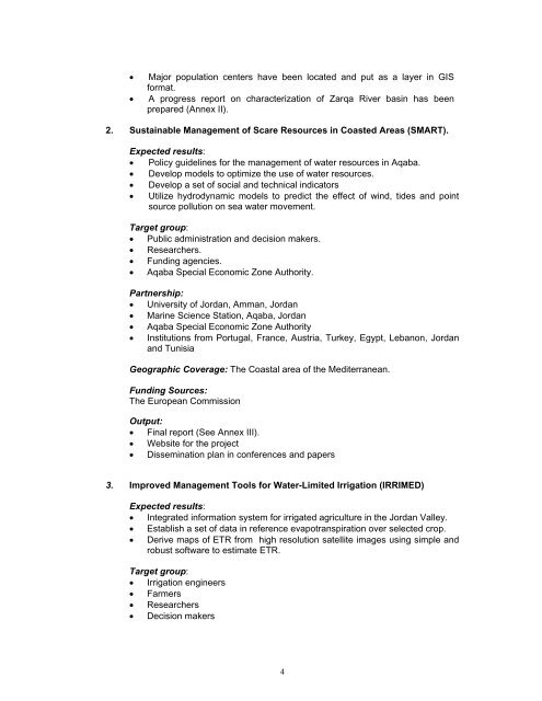
• Major population centers have been located and put as a layer in GIS<br />
format.<br />
• A progress <strong>report</strong> on characterization <strong>of</strong> Zarqa River basin has been<br />
prepared (Annex II).<br />
2. Sustainable Management <strong>of</strong> Scare Resources in Coasted Areas (SMART).<br />
Expected results:<br />
• Policy guidelines for the management <strong>of</strong> water resources in Aqaba.<br />
• Develop models to optimize the use <strong>of</strong> water resources.<br />
• Develop a set <strong>of</strong> social and technical indicators<br />
• Utilize hydrodynamic models to predict the effect <strong>of</strong> wind, tides and point<br />
source pollution on sea water movement.<br />
Target group:<br />
• Public administration and decision makers.<br />
• Researchers.<br />
• Funding agencies.<br />
• Aqaba Special Economic Zone Authority.<br />
Partnership:<br />
• <strong>University</strong> <strong>of</strong> <strong>Jordan</strong>, Amman, <strong>Jordan</strong><br />
• Marine Science Station, Aqaba, <strong>Jordan</strong><br />
• Aqaba Special Economic Zone Authority<br />
• Institutions from Portugal, France, Austria, Turkey, Egypt, Lebanon, <strong>Jordan</strong><br />
and Tunisia<br />
Geographic Coverage: <strong>The</strong> Coastal area <strong>of</strong> the Mediterranean.<br />
Funding Sources:<br />
<strong>The</strong> European Commission<br />
Output:<br />
• Final <strong>report</strong> (See Annex III).<br />
• Website for the project<br />
• Dissemination plan in conferences and papers<br />
3. Improved Management Tools for Water-Limited Irrigation (IRRIMED)<br />
Expected results:<br />
• Integrated information system for irrigated agriculture in the <strong>Jordan</strong> Valley.<br />
• Establish a set <strong>of</strong> data in reference evapotranspiration over selected crop.<br />
• Derive maps <strong>of</strong> ETR from high resolution satellite images using simple and<br />
robust s<strong>of</strong>tware to estimate ETR.<br />
Target group:<br />
• Irrigation engineers<br />
• Farmers<br />
• Researchers<br />
• Decision makers<br />
4
![Problem 1: Loop Unrolling [18 points] In this problem, we will use the ...](https://img.yumpu.com/36629594/1/184x260/problem-1-loop-unrolling-18-points-in-this-problem-we-will-use-the-.jpg?quality=85)