glacial deposits - Department of Geography - Geology - Illinois State ...
glacial deposits - Department of Geography - Geology - Illinois State ...
glacial deposits - Department of Geography - Geology - Illinois State ...

You also want an ePaper? Increase the reach of your titles
YUMPU automatically turns print PDFs into web optimized ePapers that Google loves.
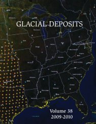
GLACIAL<br />
DEPOSITS<br />
Volume 37<br />
2008 - 2009
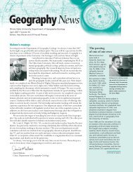
2008-2009 DISTINGUISHED GEOGRAPHER LECTURE<br />
A highlight in the <strong>Department</strong> each spring is the visit by the year’s Distinguished<br />
Geographer, who spends time with faculty and students for a couple <strong>of</strong> days, prior to<br />
delivering the namesake lecture. For 2008-2009 Dr. Ge<strong>of</strong>frey Martin, Pr<strong>of</strong>essor Emeritus<br />
<strong>of</strong> <strong>Geography</strong>, Southern Connecticut <strong>State</strong> University, fulfilled this role. Earnings from a<br />
donation by E. Joan Miller fund the series.<br />
Though they did not know one<br />
another at the time, Ge<strong>of</strong>frey<br />
Martin and the <strong>Department</strong>’s Jo<br />
Miller, both natives <strong>of</strong> England,<br />
lived through the Great Depression<br />
and the Blitz; and both later<br />
migrated to the United <strong>State</strong>s.<br />
Ge<strong>of</strong>frey has traveled the world in<br />
search <strong>of</strong> archival material to tell<br />
the story <strong>of</strong> the discipline <strong>of</strong><br />
geography.<br />
After his lecture, “History <strong>of</strong><br />
American <strong>Geography</strong>: 1870-1960,”<br />
Dagmar Budikova, who played a large<br />
role in bringing Ge<strong>of</strong>frey to campus,<br />
presented him with some tokens <strong>of</strong> our<br />
appreciation, including a Redbird cap,<br />
which he displayed in his left hand.<br />
The venue was the Circus Room <strong>of</strong> the<br />
Bone Center.<br />
Jo Miller (right) attends the annual<br />
lecture when possible. On this<br />
occasion, another departmental<br />
retiree, Jo Kimler (left), gave Dr.<br />
Miller a ride to and from the Bone<br />
Center and sat with her during the<br />
festivities.
GLACIAL DEPOSITS<br />
Volume 37<br />
2008-2009<br />
<strong>Department</strong> <strong>of</strong> <strong>Geography</strong>-<strong>Geology</strong><br />
<strong>Illinois</strong> <strong>State</strong> University<br />
Campus Box 4400<br />
Normal IL 61790-4400<br />
Homepage: www.geo.ilstu.edu<br />
Editor<br />
Michael D. Sublett<br />
Graphics<br />
Jill Freund Thomas<br />
Associate Editor<br />
David H. Malone<br />
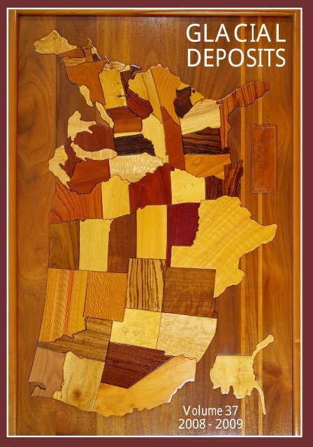
Cover: This Russell Osterloh creation has hung in the Editor’s living room since 1988.<br />
We were having dinner with family in Columbia, Missouri, one summer evening that<br />
year; and a similar map hanging behind the restaurant’s cash register caught my<br />
attention. Inquiry led me to the nearest outlet for Russell’s exquisite work, and I bought<br />
#48 in a series that now exceeds 600 maps and in which no two maps are identical. He<br />
provides an index (see page 29) as to what wood represents each state. Pieces for some<br />
states, like <strong>Illinois</strong>, come from readily available trees, while others, say Missouri, are<br />
from Latin America or other tropical latitudes. As Ellen Dietz learned in an interview for<br />
her article beginning on page 26, he likes to work with local trees that are coming down<br />
for reasons other than for a cartographic artwork or fine furniture.
TABLE OF CONTENTS<br />
2008-2009 Distinguished Geographer Lecture Inside Front Cover<br />
From the Editor’s Desk<br />
Normal Renewal<br />
iii<br />
iv<br />
Some Urban Aspects <strong>of</strong> Petroleum Production/Ellen Dietz 1<br />
Exploring Alaska for Research Ideas/Johanna Haas 6<br />
<strong>Geography</strong> Interns: Class <strong>of</strong> 2008 10<br />
Wise Words from the Pr<strong>of</strong>essoriate/Jay R. Harman 15<br />
Hall <strong>of</strong> Fame Induction 18<br />
Martha Cowart Means, 1915-2008/Robert G. Corbett 19<br />
Class Assesses the Felmley Environment/Johanna Haas 20<br />
Twentieth Annual <strong>Geography</strong> Career Fair 22<br />
Uptown Normal is Leeding the Way/Enid L. Cardinal 24<br />
The Art <strong>of</strong> <strong>Geography</strong>/Ellen Dietz 26<br />
GIS Day 2008 30<br />
Student Awards 32<br />
Majors and Graduate Students—May 2009 34<br />
Conference Presentations 36<br />
Faculty and Staff Sketches 40<br />
And Cake, Too 54<br />
<strong>Illinois</strong> versus Iowa/Indiana/Idaho/Adam Kastor 55<br />
Yesteryears/Michael D. Sublett 56<br />
2008-2009 Douglas Clay Ridgley Lecture Inside Back Cover
FROM THE EDITOR’S DESK<br />
A<br />
s I examine the table <strong>of</strong> contents early each summer for the forthcoming issue <strong>of</strong><br />
Glacial Deposits, I wonder just how this creation actually comes to be. Yes, some<br />
items are on the list because we have had them there before; and they continue<br />
to seem appropriate for a yearbook <strong>of</strong> an academic department such as ours. So we<br />
devote several pages to <strong>Geography</strong> internships, name the student award winners over<br />
the past year, list our majors and graduate students, recap presentations that faculty<br />
and students authored or coauthored, <strong>of</strong>fer faculty and staff up to half a thousand words<br />
to recap their year, and (a fairly recent addition) give the editor a page for “Yesteryears.”<br />
But what led us to the core <strong>of</strong> the yearbook, the articles<br />
Here is a brief recap <strong>of</strong> how the articles came to be for Volume 37. The idea for our lead<br />
article, the one dealing with the impact <strong>of</strong> petroleum production on an urban area,<br />
occurred to me as I listened to Tom Schickel present his Homecoming lecture in<br />
October 2008. Who would write it The closest thing that we have to a staff writer is<br />
Ellen Dietz. Always game for a challenge, Ellen said she knew next to nothing about<br />
drilling for gas, but would give it a try. While Shell’s corporate approval process for<br />
Ellen’s draft <strong>of</strong> the article unfolded in the first few months <strong>of</strong> 2009, I began to wonder if<br />
the go ahead would actually occur and whether I ought to find something else for Ellen<br />
to research and write. That was when I contacted Russell Osterloh, the artist in Oregon<br />
from whose agent in 1988 I had purchased the beautiful wooden map <strong>of</strong> the United<br />
<strong>State</strong>s that hangs on our living wall. Still busy in the woodworking art, Russell agreed to<br />
an interview; and Ellen finished the Osterloh article about the time that Shell finally<br />
signed <strong>of</strong>f on her initial article. Johanna Haas has been a busy pr<strong>of</strong>essor in her first<br />
three years at <strong>State</strong>, but she was not too busy to write (willingly) not just one but two<br />
articles about activities with her students over the past 12 months. When Jay Harman<br />
was on campus in April 2008 for his Distinguished Geographer Lecture, he and I got to<br />
talking about what he might be able to contribute to Volume 37. Sometimes veteran<br />
pr<strong>of</strong>essors have topics that have not leant themselves to articles, book chapters, or<br />
books. Jay has been a dedicated field teacher and thought that he might be able to<br />
convey some <strong>of</strong> his passion and experience in a short article for us. The first time I met<br />
Enid Cardinal she impressed me with her knowledge <strong>of</strong> the LEED certification system.<br />
Since I have to confront LEED-rich Uptown Normal twice a day as I bike commute<br />
around the construction, I asked her to write something short and not too technical for<br />
us. Bob Corbett was the obvious choice to compose the tribute article about Martha<br />
Means. Finally, there is Adam Kastor, an undergraduate who was one <strong>of</strong> my <strong>Illinois</strong><br />
(GEO 220) students in the spring <strong>of</strong> 2009. His rant about Iowa had me LOL as I scored<br />
their logbooks one winter evening. When asked if I could reprint it, he agreed.<br />
Thanks to all who contributed in other ways. Deb Lescher typed the articles and lots <strong>of</strong><br />
other text stuff; Jill Thomas performed the graphical magic; Dave Malone found the<br />
funds to print (and also provided good advice); and several contributed photographs<br />
(Shell, Johanna Haas, Chenay McDaniel, Curtis Russell, Rich Frontz and Earl<br />
Hammond, Stephanie Bussan, Jay Harman, Lyndsie Schlink, Amy Bloom, Russell<br />
Osterloh, Jed Day) to supplement those that I claim. It was an interesting year. Now I<br />
begin seeking material with which to populate Volume 38. MDS<br />
iii
NORMAL RENEWAL<br />
In 2008, <strong>Illinois</strong> <strong>State</strong> University<br />
began razing dated dormitories<br />
between Main and University to<br />
make way for the Student Fitness<br />
and Kinesiology Recreation<br />
Building. Here demolition <strong>of</strong><br />
Walker Hall had just begun (at its<br />
north end), as another dorm,<br />
Hamilton-Whitten, stood watch<br />
in the background. Dunn and<br />
Barton halls, formerly to the left<br />
(just east) <strong>of</strong> Walker, had already<br />
become history.<br />
On the east side <strong>of</strong> campus,<br />
in Uptown Normal, crews<br />
were busy early in 2009<br />
wrecking the building once<br />
occupied by University<br />
Christian Church, at the<br />
corner <strong>of</strong> North Street and<br />
Fell Avenue. In its place is<br />
to stand a $31 million<br />
structure that will have retail<br />
space on the first floor,<br />
<strong>of</strong>fices on the second, and<br />
137 rental apartments on<br />
floors three, four, and five.<br />
North Street is getting a<br />
major makeover as part<br />
<strong>of</strong> the Uptown renewal,<br />
from the traffic circle or<br />
roundabout (in the<br />
distance), past the<br />
intersection with<br />
Broadway (beyond<br />
nearest excavator), to<br />
Fell Avenue.<br />
iv
SOME URBAN ASPECTS OF PETROLEUM PRODUCTION<br />
By Ellen Dietz<br />
O<br />
nce upon a time, we imagined petroleum drilling and extraction looked like something<br />
out <strong>of</strong> the movie Giant, and, once upon a time, well, it did. But as the decades have<br />
elapsed, Texas does not look like Giant, and the oil and gas operation are no longer<br />
something scripted out <strong>of</strong> Hollywood. Perhaps the biggest change is the vast expansion <strong>of</strong><br />
population in Texas and all that goes with it: neighborhoods, strip malls, warehouses, sewer and<br />
water pipelines, highways, parking lots, and the like. Still, there is an abundance <strong>of</strong> oil and gas<br />
along the Gulf Coast yet to be tapped, beneath the urban development and agriculture.<br />
So, what happens when population and oil/gas operations collide We have come upon a<br />
special opportunity to find out. In October 2008, Thomas Schickel (B.S. in <strong>Geology</strong> 1993 and a<br />
M.S. in <strong>Geology</strong> from the University <strong>of</strong> <strong>Illinois</strong> in 2006) returned to <strong>Illinois</strong> <strong>State</strong> to speak to<br />
faculty and students during Homecoming. Tom is a geologist with Shell Exploration &<br />
Production Company in Texas and has a wealth <strong>of</strong> experience working on drilling sites in south<br />
Texas. In his presentation, Tom touched upon the intricacies involved in producing natural gas<br />
in a populated area. We wanted to know more. So, we asked what it was all about.<br />
Glacial Deposits: Surely, there is a large amount <strong>of</strong> work that must be done in advance <strong>of</strong><br />
setting up a drill site, but we want to focus on the people aspects. What are the public relations<br />
considerations when the well site is in an urban area Is there a public comment period<br />
Shell Exploration & Production Company: Shell owns a natural gas field, McAllen Pharr,<br />
located underneath the cities <strong>of</strong> McAllen, Pharr, and San Juan, Texas. More than 700,000<br />
people live in this area, and another 300,000 in the greater Rio Grande Valley. It is important to<br />
Shell to be a good neighbor in this community. Thus, we do what we can to minimize the<br />
nuisance factor <strong>of</strong> our operations. One <strong>of</strong> the ways we have done this is to purchase land sites<br />
in the area that are 5 to 20 acres in size. These sites act as drilling pads and provide a buffer to<br />
our neighbors. We then drill our wells directionally to access the oil and gas reserves, and we<br />
can use these pads to drill multiple wells. This approach minimizes our overall footprint in the<br />
area and provides buffer zones to our neighbors, reducing noise and dust.<br />
Every well drilled in a city requires a city permit, in addition to the state permit. After the permit<br />
filing, a notice appears in the newspaper advising the citizens <strong>of</strong> a hearing before the city<br />
commission to consider the permit. During the meeting, citizens have the opportunity to<br />
comment on the record as to their views on our permit. Shell gets to state its case as well. Thus,<br />
it is not a public comment period per se, but the public is informed and involved. These city<br />
council meetings are televised locally and via the Internet.<br />
GD: People are concerned about the environment around them, and one way they express this<br />
concern is through environmental impact studies. Can you give a brief explanation <strong>of</strong><br />
environmental impact studies and their role in drilling<br />
Shell: Shell takes a very proactive role in assisting with environmental impact studies and has a<br />
strong corporate culture <strong>of</strong> ensuring our operations are environmentally friendly. Though not in<br />
an urban area, a perfect example <strong>of</strong> this is in our Pinedale, Wyoming, operations. The Pinedale<br />
Anticline is a pristine setting in the Rocky Mountains with numerous protected plants and<br />
wildlife. Among these are sage grouse, deer, and elk. Shell led the effort to work with the<br />
Bureau <strong>of</strong> Land Management (BLM) to develop plans for gaining access to the natural gas with<br />
minimal impact on the native species. We worked closely with many stakeholders to survey the
wildlife populations and develop seasonal drilling plans that minimize our footprint. All the wells<br />
are drilled from pads in an effort to minimize site disturbance. The objective <strong>of</strong> an Environmental<br />
Impact Study is to define the habitat and assess the impact <strong>of</strong> changes that would be caused to<br />
this habitat by oil and gas operations.<br />
GD: Few people know the difference between surface rights and mineral rights. Could you give<br />
a nutshell explanation From a landowner’s perspective, how does not owning mineral rights<br />
affect him/her when a deposit is discovered<br />
Shell: Surface rights entitle an individual to use the surface for their own purposes. As an<br />
example, when you buy a house, you own the house and all <strong>of</strong> the property it sits on and can<br />
use that property as you see fit, within whatever restrictions are in place. Mineral right<br />
ownership means that you own the rights for any hydrocarbons that lie beneath the surface.<br />
Because you own these rights, you can lease them to oil and gas companies; and, if they find oil<br />
or gas on your property, you will financially benefit from the revenues <strong>of</strong> that oil and gas.<br />
It is very rare these days that mineral owners and surface owners are the same. One <strong>of</strong> the<br />
largest mineral owners is the federal government, although it is rare where they still own the<br />
surface. Thus, if the BLM has leased the minerals to an oil company, and the company wants to<br />
access those hydrocarbons, it can do so, even if it means disturbing the surface owners’ land.<br />
The oil/gas company will pay the surface owners for any damage inflicted upon the land as a<br />
result <strong>of</strong> these operations, but that is generally the only revenue the surface owner will receive.<br />
Thus, the federal government and the oil company continue to make money while the well is<br />
producing; but the landowner receives no revenue from the well. In Texas, the mineral owner is<br />
considered the dominant estate over the surface owner.<br />
GD: Has public opinion about drilling and production changed over the years<br />
Shell: There continues to be less access available for hydrocarbon development. The general<br />
public has become more negative about drilling over time even as our drilling techniques have<br />
improved and have less impact on the environment and surface than 25 years ago. However,<br />
the oil and gas industry could do more to communicate its value. We employ hundreds <strong>of</strong><br />
thousands <strong>of</strong> people and provide a commodity that is necessary for the nation to prosper.<br />
GD: What goes into physically preparing a drill site Reserve pits Access roads Water<br />
source Land-clearing or other changes for access, containment, environmental safeties How<br />
does being in an urban area affect preparation<br />
Shell: Once we identify a site, we clear and level the area and dig reserve pits and line them<br />
with material to ensure that the captured fluids cannot leak into the soil. If a road is necessary,<br />
then our construction crews will build the road and bring electricity to the site. Most access is via<br />
satellite for telephones and Internet connections. Water is usually trucked in to the location, as<br />
are drilling fluids and other services. In the city, we have access to local telephone and electric<br />
services. We will also employ people at the entrance to monitor personnel coming and going,<br />
and to ensure the security and the safety <strong>of</strong> those on location.<br />
GD: Let us turn our attention to the footprint <strong>of</strong> a drill site. To start, what do your drill rigs look<br />
like We would like to get a mental picture <strong>of</strong> the above-ground operation. In <strong>Illinois</strong> we have<br />
some strange-looking stand-alone rigs on the glaciated landscape, slowly, steadily bobbing up<br />
and down. Their pr<strong>of</strong>ile is reminiscent <strong>of</strong> the glass drinking-bird toys we had as kids. Are those<br />
drill rigs Is there other machinery or housing that go along with the rig How big is the overall<br />
2
footprint when you set up a drilling site, and what are the considerations when that footprint is in<br />
an urban site What is the footprint once the well is established<br />
Shell: What you are describing is actually a pumping unit and not a drilling rig. A pumping unit is<br />
necessary to get oil out <strong>of</strong> the ground after the well is drilled. Pumping units are required when<br />
the well has insufficient pressure to flow to the surface on its own. The overall footprint during<br />
the drilling operation is about three to five acres, depending on the size <strong>of</strong> the rig. Once the well<br />
is drilled, we collapse the location to a very small area by returning most <strong>of</strong> the area to its native<br />
state. Our objective is to leave as small a footprint as possible, yet leave some footprint so we<br />
can get back to work on the well in the future.<br />
In the city, we drill on pads that are ours, so those typically stay the same and are not returned<br />
to native state. However, we do fence and landscape around the area to ensure our well sites<br />
are not eyesores. Our McAllen Pharr field has some beautiful bougainvillea blooming!<br />
GD: Once you get started there must be a lot <strong>of</strong> activity. What are the considerations for all the<br />
traffic that accompanies drilling, such as supplies, generators, and water<br />
Shell: Yes, there is a lot <strong>of</strong> activity; but it is what I call controlled chaos. Shell has many driving<br />
safety policies, and we require our contractors adhere to the same standards. An entire drilling<br />
location can be picked up and moved in five days. The moving is done during the daylight to<br />
minimize the extra safety exposure associated with night activity. This procedure is safer for our<br />
crews, the public, and any wildlife. For our in-town area, we try to stick to the lesser-traveled<br />
roads to minimize the disruption to the people in the city.<br />
GD: When we think about south Texas, we get a mental picture <strong>of</strong> grapefruit orchards and other<br />
agriculture, as well as open plains and scattered cities. What can you tell us about the<br />
difference between drilling under an agricultural field as opposed to an urban setting<br />
Shell: When drilling in urban areas, the main difference is noise containment. In an urban area,<br />
we, and our drilling contractor, stack freight containers around the rig to reduce the noise. This<br />
is not necessary in the wide-open areas. We also get fewer visitors to our non-urban locations.<br />
In general, the drilling rigs for an urban area are similarly equipped to those in the open plains.<br />
Sometimes it is necessary to disturb a farmer’s planted field so that we can build a drill site. We<br />
will usually juggle our rig schedule so that we wait until after harvest to disturb the field. We<br />
have also been known to delay wells to accommodate a hunting schedule or the holidays. We<br />
believe it is important to be a good neighbor both in the urban and rural areas that we operate.<br />
GD: In person or in the movies, most <strong>of</strong> us have seen the flares from wells. With the rising<br />
awareness <strong>of</strong> global warming and pollution, these flares are increasingly in the public<br />
consciousness. Any thoughts on what companies are doing about the flares, especially in urban<br />
areas where those flares are beacons in the darkness<br />
Shell: We have tried using combustors rather than flares, but the technology has not advanced<br />
as quickly as the public conscience. We abide by all state and federal laws in this area and are<br />
actively working on improved flaring methods. If we did not flare while we were drilling in south<br />
Texas, we would not be able to continue drilling in these old fields as it would be uneconomic to<br />
recover the gas. The technologies we use to drill wells in south Texas require “underbalanced<br />
drilling.” Underbalanced means that the well is constantly flowing gas while you are drilling as<br />
the pressure <strong>of</strong> the drilling fluids during the drilling operation is less than the pressure <strong>of</strong> the<br />
formations that you are drilling.<br />
3
GD: Drilling must be a noisy activity. What are the considerations when drilling in an urban<br />
area Are there restrictions on 24-hour activity<br />
Shell: The rigs are quieter than you would think. We have done some noise surveys in our<br />
urban areas, and the freeway traffic is twice as noisy as the drilling rig. Regardless, we minimize<br />
the impact on our neighborhoods by stacking freight containers, as noted above, around our<br />
locations and using electric generators on our rigs. We have even equipped our forklifts with<br />
backup lights rather than that noisy sound (the beep, beep) that occurs when you are backing<br />
up! One <strong>of</strong> the noisiest activities is cementing the steel casing strings in the ground so that we<br />
can produce the well. This occurs several times during the drilling operations as we cement<br />
surface casing, an intermediate casing string, and finally our production casing. We will usually<br />
wait for daylight before starting one <strong>of</strong> these operations. There are no formal restrictions; this is<br />
just a policy that Shell has to minimize the disruptions to people’s lives.<br />
GD: How do you get the gas from the underground formation to the storage site (or usage site)<br />
when those two areas are not one in the same Do you use above- or below-ground pipes, and<br />
how do you choose the routes What are the public comments about those routes, and what<br />
kinds <strong>of</strong> contingency plans do companies need in case changes must be made Have you ever<br />
had to transport through or under existing urban areas<br />
Shell: We move most <strong>of</strong> the gas from the well site to the customer via underground pipelines,<br />
although there are many aboveground pipelines also. It really depends on the area. We<br />
currently transport gas under an urban area, as do many other oil and gas and pipeline<br />
companies. Nearly everyone in an urban area gets his or her gas via an underground pipeline. It<br />
is critical to maintain the integrity <strong>of</strong> our pipelines to ensure they are safe to operate. To that<br />
end, we use chemicals to keep the pipes from eroding and check the condition <strong>of</strong> the pipelines<br />
via a process called “smart pigging.” Essentially, a smart pig can tell you how much, if any,<br />
corrosion is in the pipeline. When the corrosion gets to an unsafe condition, you can either<br />
reduce the operating pressure <strong>of</strong> the pipeline or replace the corroded segments.<br />
GD: If there were three things you would want people to know about drilling in urban areas,<br />
what would they be<br />
Shell: First, Shell does everything it can to operate in a safe, environmentally friendly, and<br />
neighborly way. The people that work on those rigs <strong>of</strong>ten live in those communities, so we all<br />
share a common goal to ensure minimal disruption to the area while providing employment<br />
opportunities and energy. Second, the drilling operation is a state-<strong>of</strong>-the-art, high-technology<br />
activity. What you see on TV is not how we operate. Oil and gas are more difficult to get to all<br />
the time, and the techniques we use today were not even invented 20 years ago. We all share<br />
our concern over the environment. Third, you should expect Shell to be an active member <strong>of</strong> the<br />
community. We provide aid during hurricanes and employ a lot <strong>of</strong> local people. We contribute to<br />
the economy <strong>of</strong> the area and take our responsibilities to the area very seriously. We are proud<br />
<strong>of</strong> our annual citrus bowl, an event where we harvested more than 20 tons <strong>of</strong> citrus and donated<br />
this citrus to the local food bank for needy families.<br />
GD: And so, our story comes full circle. Modern drilling, indeed, is nothing at all like Giant.<br />
Rather than the explosive black rain <strong>of</strong> oil, drilling is a tightly controlled, high-tech industry that<br />
must consider neighborhoods, utility rights-<strong>of</strong>-way, legal matters, crop and harvest scheduling,<br />
local ordinances, noise abatement, water supplies, and a host <strong>of</strong> other concerns in addition to<br />
geomorphology and structural geology to get gas and oil to the consumer. With the expertise <strong>of</strong><br />
4
Thomas Schickel and geologists around the world, that continues to happen with environmental<br />
concern and good-neighbor practices.<br />
EDITOR’S NOTE: It take a team to drill a well, and it took a team to bring this article together.<br />
We thank Shell’s Thomas Schickel, Sandy Sodersten, and Kelly op de Weegh for their<br />
assistance and input. Without them, this article would not have been possible. Ellen Dietz has<br />
written several items for Glacial Deposits, including another article in this volume.<br />
(Left) Shell contracts with Nabors Drilling for well projects in the Rio Grande Valley, such as this one<br />
near Jackson Ridge Square, Pharr, Texas. (Right) Not much remains after the drill crew departs, except the<br />
wellhead. This image and that <strong>of</strong> the drill rig are courtesy <strong>of</strong> Shell. (Below) Tom Schickel, the inspiration<br />
for this article, posed on 17 October 2008, with two <strong>of</strong> his former pr<strong>of</strong>essors, Skip Nelson (left) and David<br />
Malone (right), with Schroeder Hall in the background.<br />
5
EXPLORING ALASKA FOR RESEARCH IDEAS<br />
6<br />
By Johanna Haas<br />
A<br />
t around midnight, on June 15, 2008, Dawn Heckmann, Phil Ferguson, and I deplaned at<br />
Anchorage, Alaska. The sky was still lit with a dull twilight that, so far north and so close<br />
to the solstice, would not go away during our two-week visit. We managed (by accident)<br />
to time our visit to cover both the summer solstice and the 50 th Anniversary <strong>of</strong> Alaska’s<br />
achieving statehood. The solstice was a bit jarring, and more than one night we found ourselves<br />
sitting up in the common room <strong>of</strong> the inn playing cards, only to suddenly look at a watch to<br />
realize it was after 10 p.m., and still looked like daytime. Phil was the one who took most<br />
advantage <strong>of</strong> the sunny nights to go for late night runs; and, consequently, he took the least<br />
advantage <strong>of</strong> early morning planning in the c<strong>of</strong>fee shop across the street from the inn.<br />
I went to Alaska in search <strong>of</strong> a research question. My prior research looked at law and property<br />
ownership and how they interacted with mountaintop removal coal mining in West Virginia and<br />
Kentucky. I still wanted to look at land that held energy resources and sat in a rural area–and<br />
the geologists in the <strong>Department</strong> had filled my head with many interesting stories <strong>of</strong> research in<br />
Alaska, so I decided to head north. I picked two undergraduates to come along as research<br />
assistants to help me flesh out a research agenda. Phil was interested in learning about Alaskan<br />
Natives and their interactions with the physical environment. Dawn was interested in learning<br />
about energy extraction and policy. This short essay recounts some <strong>of</strong> our adventures.<br />
On the first morning, Dawn and I engaged in those most basic <strong>of</strong> research techniques: going for<br />
a walk around the neighborhood, watching the local news, and buying a newspaper. That<br />
quickly led us to discover that public hearings about state support for a natural gas pipeline to<br />
run down from the North Slope were happening downtown. We spent two days attending those<br />
hearings, the first listening to scientific presentations by state regulators on the pipeline. The<br />
second day we listened to an <strong>of</strong>ten quite rowdy citizen response. Highlights included a trio<br />
singing a parody <strong>of</strong> “How Do You Solve a Problem Like Maria” from the Sound <strong>of</strong> Music and a<br />
man who blamed all problems on the existence <strong>of</strong> the Federal Reserve. We also got to watch<br />
interactions between members <strong>of</strong> the Alaska Senate and House, and picked up some stray<br />
gossip that several <strong>of</strong> them are just as colorful as members <strong>of</strong> the public. The new gas pipeline<br />
made it to the list <strong>of</strong> items I may want to look into more as I build a research agenda.<br />
Our tiny team engaged in various types <strong>of</strong> research, both traditional and unusual. We found a<br />
meeting at a c<strong>of</strong>fee shop about environmental construction and a service at a Unitarian Church<br />
about the history <strong>of</strong> Alaskan corruption. We visited the public library and the library at the<br />
University <strong>of</strong> Alaska-Anchorage, in order to find archival records <strong>of</strong> resource use in the<br />
Anchorage area. We stopped by government agencies including the U.S. public lands <strong>of</strong>fice and<br />
the Alaska <strong>Department</strong> <strong>of</strong> Natural Resources. We chatted with groups involved in mining and<br />
environmental issues: Alaskans Against the Mining Shutdown, The Nature Conservancy, The<br />
Cook Inlet Keeper, and the Renewable Resource Coalition. At the time, I thought my research<br />
might take me toward conflicts surrounding mining for coal and other resources.<br />
We road tripped outside <strong>of</strong> Anchorage to discover the area, travelling down the Kenai Peninsula<br />
to Seward, and seeing some Dall sheep along the way. One <strong>of</strong> the things that everyone should<br />
have on their bucket list is to see a glacier. On the trip to Seward we visited two. First, we<br />
stopped at Portage Glacier Park, outside <strong>of</strong> Anchorage. We soon saw a glacier, assumed that it<br />
was Portage; found a place to park the car; and began hiking toward the glacier. What I had
thought was a hiking trail ended up being a moose trail through a dense thicket <strong>of</strong> willows and<br />
soon gave out. We managed to emerge from the willows at a stream <strong>of</strong> <strong>glacial</strong> melt-water and<br />
follow that toward the glacier for a while. Phil managed to spot some bears on the hill above us–<br />
luckily at a very safe distance–and we watched them for a while. We had to turn back before<br />
reaching the glacier because we were not dressed to hike through the snow or water it would<br />
take to reach it. Eventually we made it to the visitor center, only to discover that we found Byron<br />
Glacier instead <strong>of</strong> Portage, and that there was indeed a trail on the other side <strong>of</strong> the stream. Our<br />
second glacier <strong>of</strong> the day was Exit, outside <strong>of</strong> Seward. Here, the park rangers had placed signs<br />
marking the glacier’s rapid retreat because <strong>of</strong> climate change. We did get close enough to touch<br />
it, and I have never felt so small in my life as standing next to that glacier. It was cold and so<br />
massive as to create its own wind, which soared through its cracks and crevasses making a s<strong>of</strong>t<br />
singing sound, while it glowed blue as the light shone through its layers.<br />
Toward the end <strong>of</strong> our time in Alaska, the Supreme Court announced the final verdict about the<br />
Exxon Valdez oil spill. Since we were close enough (the drive from Anchorage to Valdez was<br />
supposed to be about six hours), we decided to drive to the port city and see if there was<br />
anything going on. We were able to view, but not approach, the facilities at the end <strong>of</strong> the oil<br />
pipeline, but were unable to find much going on in the town in reaction. However, on our drive<br />
back, we stopped at a roadhouse for breakfast. As I was teaching the students about the Valdez<br />
court case, a man at the table next to us said, “Excuse me, I can’t help but overhearing you talk,<br />
and I am one <strong>of</strong> the claimants from the oil spill.” It turns out he was a fisherman who was put out<br />
<strong>of</strong> business as a result <strong>of</strong> the damage caused by the spill. He spoke with us for a while about his<br />
difficult experiences making claims, and his frustration with the bureaucracy that was put in<br />
place to deal with claims. We learned about the difficulties <strong>of</strong> a fisher’s life in Alaska and the<br />
spatially differing application <strong>of</strong> the law between Cook Inlet and Prince William Sound. That<br />
stroke <strong>of</strong> luck really added to our understandings <strong>of</strong> the issues.<br />
My favorite place, however, turned out to be nowhere near so far away. Just north <strong>of</strong> Anchorage<br />
lies the Matanuska Valley nestled between the Chugach and Talkeetna mountains along the<br />
Matanuska River, which melts from the Matanuska Glacier. This valley has a long history <strong>of</strong><br />
mining, and holds a state park that was once the Independence Gold Mine. It also holds coal<br />
<strong>deposits</strong> between the towns <strong>of</strong> Palmer and Chickaloon, coals that had been mined by the U.S.<br />
Navy and by commercial operations in the past as underground mines. There is one surface<br />
mine still operating in the reclamation stage, the Jonesville Mine; and we hiked up to it, finding<br />
the entrance to the old Evan Jones underground mine up the mountain. Here I came to the<br />
realization that this coal was interesting. It was located along a major road close to Anchorage,<br />
and the seams contained every type <strong>of</strong> coal from lignite to bituminous and even some<br />
anthracite. Additionally, private entities own some <strong>of</strong> this land, while the state and federal<br />
governments owned other parts; and there was even a native village tribal corporation in<br />
Chickaloon that owned some <strong>of</strong> the coal. While the coal itself is not being developed today, the<br />
methane (natural gas) that it holds is <strong>of</strong> interest to many groups. One entity had tried to develop<br />
it in 2003, but was chased away by the locals. Another looked to be ready to drill a test well in<br />
2009 and was encountering little opposition. This would be the perfect place to look at resource<br />
extraction from the beginning and to help determine why the community welcomed the one<br />
developer and discouraged another.<br />
The Matanuska Valley is interesting for more than just coal and gas, however. During the Great<br />
Depression, one program settled it with farmers from the northern Great Plains in an effort to<br />
build a self-sustaining agricultural community in Alaska. While most <strong>of</strong> those settlers left to get<br />
oil jobs, there are still innovative farmers in the area including a musk ox farm, a reindeer farm,<br />
and several vegetable farms that sell to restaurants and the Anchorage farmers’ market. This<br />
7
area is largely rural, but exploding in population growth as Anchorage spreads. (This is the area<br />
from which Sarah Palin hails; and we got to hear the governor speak as part <strong>of</strong> Alaska’s 50 th<br />
Anniversary Celebration.) It pulls people who want the traditional Alaskan lifestyle <strong>of</strong> outdoor<br />
abundance and self-sufficiency, but who still wish to live close enough to a city to be able to<br />
access its amenities. As such, the valley is undergoing rapid change and should provide a host<br />
<strong>of</strong> issues to look into with students over time.<br />
One thing I learned is that there is nothing subtle about Alaska–both the landscape and people<br />
are larger-than-life. Photographing the landscape is impossible because the mountains, valleys,<br />
and waters simply cannot fit into a lens frame. The Alaskan people love their home, and<br />
treasure the environment, considering themselves to be very good stewards. They are naturally<br />
suspicious <strong>of</strong> anyone from the Lower 48 coming in to tell them what to do without building the<br />
deep understandings they have built up over the years. Still, many people seem to have an<br />
uneasy relationship with the energy resources that have brought such wealth to their state, but<br />
have also, as in the case <strong>of</strong> the Exxon Valdez disaster brought great harm.<br />
Phil gets the award for outstanding inter-human interaction. He would talk to anyone about<br />
anything. When we travelled west along the Glenn Highway toward some old coal mines, Phil<br />
was the one who chatted with the workers in small stores along the way to get information on<br />
the mines. He interviewed Alaskan Natives selling their goods at the Anchorage Farmers’<br />
Market and at the Alaskan 50 th Anniversary <strong>of</strong> <strong>State</strong>hood Celebration. Phil even used the<br />
occasion <strong>of</strong> a night <strong>of</strong> Irish dancing to interview participants about their feelings about mining<br />
and the environment.<br />
Dawn receives the award for indefatigability and attention to detail. She took on every grueling<br />
and difficult task without complaint–even becoming our full-time driver, which included the ninehour<br />
trip to Valdez. Dawn was the first to spot relevant events in the news and note that we may<br />
want to attend this or that, and was the only research assistant not to fall asleep in the public<br />
library looking over environmental agency public files. She also took on the task <strong>of</strong> cataloging all<br />
the field relics upon our return to <strong>Illinois</strong>.<br />
I am now set to embark on a new research agenda–and will take more students to Alaska. We<br />
will be looking at both coal-bed methane and general natural gas development in the Matanuska<br />
Valley in South-Central Alaska, north <strong>of</strong> Anchorage. I return May 2009 with Dawn and<br />
Environmental Studies minor Amanda Landers to look at property ownership records, and<br />
compare resource development on lands that are owned in different ways (by private people, by<br />
native corporations, or by the state or federal government.) Natural gas is frequently seen as a<br />
good transition fuel between our current fossil fuel economy and a new carbon-free renewable<br />
resource economy. Natural gas is abundant and lower in carbon than coal or oil. However, its<br />
extraction will have strong impacts, both positive and negative, on the (mostly) rural<br />
communities in which it is found. All these impacts are heightened by the climatic extremes and<br />
intense rurality <strong>of</strong> Alaska, which should provide research questions for many years to come. I<br />
hope to be able to finance return trips with more <strong>of</strong> our students in years to come.<br />
EDITOR’S NOTE: Johanna Haas and other new departmental faculty receive start-up funding to<br />
assist them with their research agenda. She used some <strong>of</strong> her funds to make this 2008 trip with<br />
her students, in addition to resources provided by a University Research Grant and an Honors<br />
Summer Research Mentorship.<br />
8
(Upper Left) Dawn Heckmann (left) and Phil<br />
Ferguson were fording a stream in order to reach<br />
Byron Glacier on the Kenai Peninsula, Alaska.<br />
(Upper Right) Johanna Haas paused amid the<br />
snow at the entrance to Independence Mine, an<br />
old gold extraction site in Hatcher Pass, Alaska.<br />
(Left) The Exit Glacier, as recently as 1995, had<br />
its snout, or terminal face, at the point where<br />
(left to right) Johanna Haas, Dawn Heckmann,<br />
and Phil Ferguson stood in June 2008. By then<br />
the snout had retreated far up the valley, but was<br />
still visible.<br />
9
GEOGRAPHY INTERNS: CLASS OF 2008<br />
Florida was where Chenay McDaniel<br />
wanted to intern; and she found herself<br />
a nice slot at the St. Augustine, Ponte<br />
Vedra, and the Beaches Convention<br />
and Visitors Bureau, near St.<br />
Augustine’s Castillo de San Marcos<br />
National Monument, where<br />
construction began in 1672.<br />
Casey Eberlin had the<br />
opportunity to spend the<br />
summer <strong>of</strong> 2008 working at<br />
Sanborn Map, in<br />
Chesterfield, Missouri, a far<br />
western suburb <strong>of</strong> St. Louis.<br />
With Casey, in front <strong>of</strong> the<br />
firm’s Piper Navaho Twin,<br />
which collected some <strong>of</strong> the<br />
aerial imagery that Casey<br />
manipulated for his<br />
internship, were General<br />
Manager Bob Williams (left)<br />
and Flight Operations<br />
Director Dale Berges.<br />
Working under the<br />
supervision <strong>of</strong> Tim Young<br />
at the <strong>Illinois</strong> <strong>State</strong><br />
Geological Survey, Rocky<br />
Bundy became in a few<br />
short weeks quite<br />
competent in the operation<br />
<strong>of</strong> equipment used to<br />
collect downhole<br />
information from wells,<br />
such as this practice hole on<br />
the main campus <strong>of</strong> the<br />
University <strong>of</strong> <strong>Illinois</strong>.<br />
10
Mandli Communications, Madison,<br />
Wisconsin, contracts with state<br />
highway departments and then sends<br />
out road crews to collect data about<br />
conditions <strong>of</strong> highways, interchanges,<br />
etc. Among the several Mandli crews<br />
in the field during 2008 was the team<br />
<strong>of</strong> Rich Frontz (left) and Earl<br />
Hammond, shown here in Henderson,<br />
Nevada, just outside Las Vegas.<br />
Stephanie Bussan was our<br />
other Mandli Communications<br />
intern in 2008; and her main<br />
assignment was Tennessee,<br />
though she also got to work in<br />
several other eastern states.<br />
Here she was gassing up the<br />
company vehicle (The Grey<br />
Goose) in Indianapolis.<br />
Rich Sullivan (right) found an<br />
internship in his hometown <strong>of</strong> Lincoln,<br />
working for Ge<strong>of</strong>f Ladd (left) and the<br />
Abraham Lincoln Tourism Bureau <strong>of</strong><br />
Logan County. The Bureau was<br />
assisting with the restoration <strong>of</strong> The<br />
Mill, on old Route 66, in Lincoln.<br />
11
More Interns<br />
We placed our first intern at the<br />
Chicago Transit Authority,<br />
Nick Puczkowskyj (center). His<br />
job entailed helping his<br />
supervisor, Todd Bapton (left),<br />
with the Bike and Ride<br />
Program. Farther up Nick’s<br />
chain <strong>of</strong> command was John<br />
Paquet (right), the CTA Vice<br />
President for Planning and<br />
Development. John is a<br />
<strong>Geography</strong> graduate from<br />
<strong>Illinois</strong> <strong>State</strong>.<br />
Nate Rock (left) worked with Mike<br />
Behary (right) at McLean County<br />
Building and Zoning, at their<br />
Bloomington <strong>of</strong>fice, primarily<br />
doing GIS mapping. Mike, a<br />
planner in Building and Zoning, is<br />
also a <strong>Geography</strong> graduate from<br />
<strong>Illinois</strong> <strong>State</strong>.<br />
DuPage County GIS, in<br />
Wheaton, is near the parental<br />
home <strong>of</strong> Jim Tompkins (right)<br />
and proved to be a fine choice<br />
for his required <strong>Geography</strong><br />
internship. Supervising Jim was<br />
Bill Syversen (left).<br />
12
We had two interns in Rock Island.<br />
Daniel Heggen (left) worked for<br />
Thomas Ayers (right) at City Hall in<br />
Finance and Inspections. Daniel spent<br />
much time walking in an older area <strong>of</strong><br />
the city assessing quality <strong>of</strong> housing.<br />
The other Rock Island intern, Todd<br />
Green (left), was in the field almost<br />
exclusively, using the Global<br />
Positioning System to find and mark<br />
utility sites owned by the city. His<br />
supervisor was Randall Tweet (right).<br />
Bloomington was the location for Nick<br />
Peters’s internship at McLean County<br />
Information Technology. Nick worked<br />
in the GIS section, under the<br />
supervision <strong>of</strong> <strong>Illinois</strong> <strong>State</strong><br />
<strong>Geography</strong> graduate Leah Owens<br />
Sweeney.<br />
13
Curtis Russell went<br />
through the SCA<br />
(formerly Student<br />
Conservation<br />
Association) to obtain<br />
his internship at<br />
Curecanti National<br />
Recreation Area in<br />
Colorado. He got a<br />
chance during personal<br />
time to hike down into<br />
the Black Canyon <strong>of</strong><br />
the Gunnison, which<br />
was to his immediate<br />
rear in this image.<br />
Even before there was a<br />
required <strong>Geography</strong><br />
internship at <strong>Illinois</strong> <strong>State</strong>,<br />
our students were finding<br />
internships for credit at<br />
the McLean County<br />
Regional Planning<br />
Commission, in<br />
Bloomington. Sarah<br />
Tedrow (center) is the<br />
latest in that long lineup.<br />
Her supervisor was<br />
Jennifer Sicks (left), and<br />
her colleague was Melissa<br />
Dougherty-O’Hara (right),<br />
a 2007 graduate from our<br />
<strong>Geography</strong> program.<br />
Mike Maroon (right)<br />
interned at GIS Solutions,<br />
Springfield, back in 1994<br />
and has been there since<br />
then, except for some<br />
deployment time with the<br />
Army National Guard. In<br />
2008, Mike welcomed Chris<br />
Walker (left) as a GIS<br />
intern.<br />
14
WISE WORDS FROM THE PROFESSORIATE:<br />
REFLECTIONS ON A CAREER OF FIELD TEACHING<br />
By Jay R. Harman<br />
L<br />
ooking back on one’s teaching career is either a welcomed privilege or unpleasant<br />
obligation that we retired and retiring faculty types get asked to do a lot <strong>of</strong>. We are, <strong>of</strong><br />
course, fortunate to have a career to look back from; and, by the time we reach this point<br />
in our lives, we sometimes have insight into just what worked and what did not that we wish we<br />
had had years earlier. One question I find personally intriguing is who or what experiences most<br />
influenced us faculty as we each developed our own instructional methods or research<br />
agendas. With me, as I complete my 41 st , and last, year <strong>of</strong> full-time employment at Michigan<br />
<strong>State</strong> University, such a retrospective has to have field experiences right at its center.<br />
I think the beginnings <strong>of</strong> that emphasis go all the way back to my freshman year in the<br />
<strong>Department</strong> <strong>of</strong> <strong>Geography</strong> at <strong>Illinois</strong> <strong>State</strong> Normal University in 1959-1960 (it had yet to change<br />
its name to <strong>Illinois</strong> <strong>State</strong> University); my first introduction to field instructional came in my spring<br />
semester Economic <strong>Geography</strong> course taught by none other than Dr. Arthur Watterson himself.<br />
While Pr<strong>of</strong>essor Watterson had a warm and gentle charisma that drew students toward him and<br />
made the entire course a delight, one highlight <strong>of</strong> the semester was a field trip we took by bus<br />
to the Keystone Steel and Wire company near Peoria where, among other sights, we were<br />
treated to a peek through the steel oven peep hole at the molten metal within. That first collegelevel,<br />
and seemingly humble, field trip experience was the highlight <strong>of</strong> the course for me; and,<br />
looking back on it, little did I know that it helped cement what would later become a deep<br />
appreciation for the pedagogical value <strong>of</strong> field instruction in my own teaching. On that cool, gray<br />
Saturday, Pr<strong>of</strong>essor Watterson had planted a seed in my head.<br />
Trips in other courses at ISNU followed, and gradually my love affair with them grew. On one<br />
particular trip, led by geologist Tom Searight, who later would become my graduate advisor in<br />
the <strong>Department</strong>, we examined exposures along the <strong>Illinois</strong> River and some <strong>of</strong> its tributaries. I<br />
confess to having forgotten most <strong>of</strong> what was said at those stops, but I will never forget sharing<br />
a lunch with him and other students on the grounds <strong>of</strong> Jubilee College <strong>State</strong> Park, taking in a<br />
panoramic view <strong>of</strong> a nearby valley and listening to a discussion <strong>of</strong> how that view could be<br />
woven into a complicated narrative <strong>of</strong> geologic and geomorphic history. I myself was always a<br />
lumper rather than a splitter as I tried to understand the world, and seeing that particular big<br />
picture all at once was something <strong>of</strong> a “Eureka moment” for me.<br />
When the time came for me to identify a thesis topic in my graduate program at (by now<br />
renamed) ISU, my preference that the research question involve field, rather than only<br />
laboratory or library, investigation was already set. My topic concerned the evolution <strong>of</strong> crosssectional<br />
asymmetry <strong>of</strong> small stream valleys in west-central <strong>Illinois</strong> and the influence slope<br />
aspect had on erosional processes that led to it. Although my data were scant (as was my<br />
thesis), my zeal for field interpretation was already strong. The most memorable part <strong>of</strong> it was<br />
the time I spent trying to unravel the problem in the field.<br />
I carried that developing love for field work with me when I next enrolled in my doctoral program<br />
at <strong>Illinois</strong> in 1964 and opted for a field-based term paper topic in one <strong>of</strong> my graduate geography<br />
15
courses during my first semester. But it was not until my second year in that program that, by<br />
chance, I became thoroughly sold. While shopping around for a course to fill an opening in my<br />
fall semester schedule, by coincidence, I quite literally bumped into a classmate <strong>of</strong> mine, who<br />
recommended that I consider taking a plant ecology course, which Pr<strong>of</strong>essor L.C. Bliss in the<br />
<strong>Department</strong> <strong>of</strong> Botany then taught. Among his many strengths, Pr<strong>of</strong>essor Bliss was an<br />
indefatigable field tripper. Each fall weekend, right up to November, all 60 or so <strong>of</strong> us, as a part<br />
<strong>of</strong> his plant ecology course, had to participate in field experiences ranging from half-day<br />
sessions to full-weekend events, visiting examples <strong>of</strong> varied plant communities or research<br />
plots. We saw sand prairies near Havana, <strong>Illinois</strong>; beech forests at Turkey Run <strong>State</strong> Park<br />
(Indiana); cypress-tupelo swamps in the Cache River Valley (<strong>Illinois</strong>); and bogs and sand dune<br />
communities in southwest Michigan. Once that course ended, we had other opportunities for<br />
trips with him over spring break each year to such destinations as the Sonoran Desert and<br />
Great Smoky Mountains National Park. We always camped on the adventures, we saw an<br />
incredible range <strong>of</strong> plant species and habitats, and I was hooked. What A. Watterson had first<br />
planted in my head L.C. Bliss had brought to full flower. He showed me not only how it could be<br />
done, but that it could be done with large numbers <strong>of</strong> students.<br />
As a result, when I was hired at Michigan <strong>State</strong> in 1968 to initiate a biogeography specialization<br />
within the <strong>Department</strong> <strong>of</strong> <strong>Geography</strong>, I knew my courses had to incorporate field instruction. But<br />
I was not confident taking students into the field myself until I had first gained more competency<br />
with field botany around the eastern United <strong>State</strong>s (the region my courses emphasized), so I<br />
undertook a crash course to learn this material on my own by visiting many sites <strong>of</strong> reputed<br />
plant geographical significance and learning something about their local flora. Reconnaissance<br />
trips to Michigan’s Upper Peninsula, the southern Appalachian Mountains and the Southeast in<br />
general, and the Ozark Plateau followed.<br />
Gradually, as my confidence grew, I began working field instruction into my courses, with mixed<br />
success. My very first overnight field trip was to the eastern Upper Peninsula in May, 1970, on a<br />
day when Sault St. Marie, Michigan, set an all-time 24-hour rainfall record; and all the tents we<br />
took developed severe leaks (like my mentor, L.C. Bliss, I always camped on my field trips). On<br />
top <strong>of</strong> that, one <strong>of</strong> the students lost his money-laden wallet at a stop, throwing <strong>of</strong>f our schedule<br />
by hours as we waited for him to go back and search for, and find it intact. Undaunted, in May<br />
1971, I took my first contingent <strong>of</strong> students to Great Smoky Mountains National Park (truly a<br />
treasure trove <strong>of</strong> plant geographical insights), and in May 2008, I took what will likely be my last<br />
trip back there. In between, other trips went to the Ozark Plateau and the Boston Mountains,<br />
the Upper Peninsula, and the Coastal Plain.<br />
It was to the Smokies, however, that I returned most <strong>of</strong>ten, taking hundreds <strong>of</strong> students in total<br />
through the years. As the largest expanse <strong>of</strong> old-growth forest in the East, and with some<br />
incomparable surviving stands, it contains some <strong>of</strong> the best examples <strong>of</strong> deciduous forest in<br />
North America. Although, with so many return visits, I saw many changes in the forests and had<br />
a wealth <strong>of</strong> experiences (ranging from heavy rains to mountain snowfall and including the loss<br />
<strong>of</strong> many <strong>of</strong> the individual monarch trees I had come to know), I was fortunate beyond measure<br />
never to have had an injury or accident through all those years. What we did do was marvel<br />
together at breathtaking views; share moments <strong>of</strong> beauty that sometimes even brought tears to<br />
our eyes; spin narratives over lunch or around campfires about species interactions,<br />
environmental controls, and site histories; and engage in the wildest speculation about how<br />
things all seem to fit together. Through it all, the inspiration I felt as a student that one fine<br />
spring day sitting on the bluff at Jubilee College <strong>State</strong> Park was never far from my mind.<br />
16
To me, there is no doubt that, <strong>of</strong> all the educational experiences (classes and scholarship) I<br />
have provided others in my pr<strong>of</strong>essional career, none come close to touching so many lives so<br />
pr<strong>of</strong>oundly as the time I have spent with students in the field. I know this because I have been<br />
honored to see some <strong>of</strong> them incorporate field instruction in their own courses as they have<br />
become college faculty, or because they report revising their own academic career trajectories<br />
as a consequence <strong>of</strong> their experiences on my trips.<br />
But I take little credit for any <strong>of</strong> these outcomes. With a careful selection <strong>of</strong> sites and thorough<br />
preparation, a field trip almost runs itself in the hands <strong>of</strong> responsible students. What matters<br />
most is taking them into the field in the first place so that the chemistry can go to work. I like to<br />
challenge students in my environmental ethics class by asking them how we can hope to<br />
motivate more respectful behavior toward the environment. While rational argument about what<br />
we should do can change minds (and behavior), the view from Deep Ecology is that such<br />
change has to come more from the heart than from the head since, it is reasoned, we are more<br />
likely to take care <strong>of</strong> what we love.<br />
If so, as instructional enhancements, field trips work on more than one level. While they<br />
provide insight and understanding <strong>of</strong> things around us, they can also inspire. Looking back, I<br />
have learned that merely taking students into the field, however humble the experience may be,<br />
not only opens the door to new insights but also can help them develop a bond with the natural<br />
environment, providing them an affective reason to be better environmental stewards. As with<br />
so many things in life, I think there are more beneficial dimensions to field instruction than at<br />
first glance meet the eye.<br />
EDITOR’S NOTE: Jay Harman was a student in the <strong>Department</strong> in the late 1950s and early<br />
1960s, before earning his Ph.D. in <strong>Geography</strong> at the University <strong>of</strong> <strong>Illinois</strong> and taking a teaching<br />
position at Michigan <strong>State</strong> University. In the spring <strong>of</strong> 2008 he returned to <strong>Illinois</strong> <strong>State</strong> to deliver<br />
the Distinguished Geographer Lecture.<br />
Jay Harman (center) took one<br />
last instructional field trip to<br />
the Great Smoky, Mountains in<br />
May <strong>of</strong> 2008, along with an<br />
assortment <strong>of</strong> faculty members<br />
and graduate students from<br />
Michigan <strong>State</strong>. Here they<br />
were on the trail to Andrew’s<br />
Bald, in the higher reaches <strong>of</strong><br />
the national park, trying to<br />
understand some facets <strong>of</strong> the<br />
boreal forest (its southern<br />
Appalachian version).<br />
17
HALL OF FAME INDUCTION<br />
Dr. E. Joan Miller, retired<br />
Pr<strong>of</strong>essor <strong>of</strong> <strong>Geography</strong>, is the<br />
<strong>Department</strong>’s most recent<br />
inductee into the College <strong>of</strong><br />
Arts and Sciences Hall <strong>of</strong><br />
Fame. At her induction, in<br />
March 2009, she spoke about<br />
her journey from teacher in<br />
England to pr<strong>of</strong>essor in the<br />
United <strong>State</strong>s.<br />
Her long-time colleague and<br />
friend, Michael D. Sublett (left),<br />
introduced her to the large crowd<br />
in the Bone Center as a pioneer, a<br />
warrior, and a scholar. Interim<br />
Dean James E. Payne (right)<br />
presented her with a handsome<br />
plaque.<br />
Inductees gathered for a group<br />
photo. From the left, were<br />
President Al Bowman, Sarz<br />
Maxwell, Herman Brockman,<br />
<strong>State</strong> Senator Dan Rutherford,<br />
Dr. Miller, Stan Rives, Michael<br />
Miller, Warren Harden, and<br />
Dean Payne. Credit for all<br />
induction photos: Lyndsie<br />
Schlink/University<br />
Photographer<br />
18
MARTHA COWART MEANS, 1915-2008<br />
By Robert G. Corbett<br />
M<br />
ost faculty and students have seen the plaque on a Felmley second floor door<br />
designating the room as the George and Martha Means Seminar Room. This<br />
room honors two persons who have brought great honor to our <strong>Department</strong>.<br />
Martha Means was a gracious person, radiating the southern charm acquired at her<br />
birthplace, Birmingham, Alabama. Most recently, she lived in Greenwood, Indiana,<br />
where she and husband George moved in retirement in 1977. Martha passed away on<br />
November 20, 2008.<br />
Gail and I grew to know Martha through George, and their visits to campus and our visits<br />
to their home at Greenwood Village. She would fix us a light lunch and join with us in<br />
pleasantries and also in serious conversations about how their estate could strengthen<br />
our program. She outlived George by eight years, and kept in contact with us through<br />
mail and by phone. Each Christmas Gail would bake a stollen from an old family recipe<br />
and send it to Martha. She lived a wonderful life, attended Florida <strong>State</strong> and the<br />
University <strong>of</strong> Tampa, and graduated from Western Kentucky University. They resided in<br />
Evanston, and she served as his assistant in Rotary International.<br />
George joined the staff <strong>of</strong> Rotary in 1935 and remained active except for his service as<br />
Commander in the U.S. Navy Hydrographic Office, Division <strong>of</strong> Navigation, in<br />
Washington. From 1953 through 1972, George served Rotary as General Secretary.<br />
Please see Glacial Deposits, 2000-2001, for more details on George.<br />
Martha was a Paul Harris Fellow (Founder <strong>of</strong> Rotary) and accompanied George on<br />
many <strong>of</strong> his world-wide travels. She became an avid photographer and active in<br />
gardening and flower arranging clubs. Her civic interests extended beyond Rotary. For<br />
example, she served as a board member <strong>of</strong> Northwestern University’s YWCA, the<br />
Northwestern Settlement House, and the Evanston Women’s Club.<br />
Their legacy to us is beyond significant accomplishments and lives <strong>of</strong> honor and<br />
integrity. They have provided funding to the <strong>Illinois</strong> <strong>State</strong> University Foundation to<br />
establish the Margaret Means Endowment Stipend, the Ridgley Visiting Pr<strong>of</strong>essorship <strong>of</strong><br />
<strong>Geography</strong>, and the George R. Means <strong>Geography</strong> Scholarship. Originally each fund was<br />
estimated to receive about $500,000. The Means also provided gifts to other programs<br />
on campus. Margaret Means stipends <strong>of</strong> $2000 are for <strong>Geography</strong> majors who have<br />
unpaid internships, student practice teaching, or travel to study geography in the field for<br />
an extended period. The George R. Means <strong>Geography</strong> Scholarship provides $5000 for a<br />
year’s assistance to a <strong>Geography</strong> major exemplifying high potential and outstanding<br />
personal characteristics. The Douglas Clay Ridgley Visiting Pr<strong>of</strong>essorship was planned<br />
as a one semester appointment every four years. We decided to start the program with<br />
an alternate, the Ridgley Lecturer, until such time as funds became available. Our first<br />
Ridgley Lecturer was Gilbert M. Grosvenor <strong>of</strong> the National Geographic Society.<br />
As soon as funds are transferred to <strong>Illinois</strong> <strong>State</strong>, they can begin accumulating income to<br />
pay for the Visiting Pr<strong>of</strong>essor. Until the endowments were available upon Martha’s<br />
passing, she provided funds annually to get these programs started.<br />
19
CLASS ASSESSES THE FELMLEY ENVIRONMENT<br />
By Johanna Haas<br />
T<br />
he human-environment relationship stands as one <strong>of</strong> the core elements <strong>of</strong> the discipline <strong>of</strong><br />
geography. Some students at <strong>Illinois</strong> <strong>State</strong> spent the fall semester <strong>of</strong> 2008 closely<br />
examining their own environment, Felmley Hall <strong>of</strong> Science. The students in my Living in<br />
the Environment class (GEO 205) engaged in a self-designed analysis <strong>of</strong> Felmley Hall and<br />
Annex, which explored their environmental and energy impacts. Ideally, the resulting document<br />
will help the University with its facilities planning–and hopefully encourage decision makers to<br />
make green building and green renovation a permanent part <strong>of</strong> development and growth. This<br />
paper reviews the class project.<br />
Each student selected an issue about the building for which he or she could design a research<br />
problem, carry out fieldwork, and write up the results in report form. Students looked at such<br />
topics as water use, lighting, ventilation, heating systems, and other building functions. Others<br />
tied the building to the broader world: looking into laws, environmental certification programs,<br />
and impacts <strong>of</strong> classrooms on education. A final team <strong>of</strong> students took all <strong>of</strong> the disparate<br />
information from the class and turned it into a final report.<br />
Students found many ways to gather data. They interviewed and surveyed faculty, staff, and<br />
their fellow students. One team used the Internet site Facebook to gather opinions from their<br />
fellow students in innovative ways. Others sat down with several <strong>of</strong> the experts already working<br />
on campus to learn from them. Some students counted lights, windows, and faucets–creating<br />
graphs and tables to document their findings. Still others delved into the academic literature or<br />
learned to navigate laws and regulations. Every other Friday, they met to discuss their results<br />
and give each other aid on flagging parts <strong>of</strong> the project.<br />
The first thing that the class found is that there is too much information for one class to gather in<br />
one semester alone. Preliminary results include that many people love “Old Felmley” for its<br />
aesthetic and historic values–but people place less value on the Annex. Existing environmental<br />
programs in the University, while a great start, need expansion, particularly in the area <strong>of</strong> energy<br />
because building usage creates 50 percent <strong>of</strong> the carbon we release. Both buildings need<br />
renovation for energy and other environmental features. The least efficient part <strong>of</strong> the buildings<br />
are the heating and cooling systems, which could follow other University plans (like the new<br />
chillers) to be made more efficient. Felmley could benefit from a number <strong>of</strong> energy-saving<br />
features, such as double-paned windows, light and water sensors, and more attention paid to<br />
insulation. The University could improve environmental quality by adding devices like dusttrapping<br />
mats at the doors to improve indoor air quality. Another option is to look forward and<br />
build a new green state-<strong>of</strong>-the-art science facility, which could serve not only as a home for<br />
classrooms, <strong>of</strong>fice, and labs, but as a classroom and lab itself. Changes to Felmley can build on<br />
the University’s existing successes <strong>of</strong> the recycling program, Reggie Ride, and others.<br />
Next year’s GEO 205 class will finish the report, filling in gaps and looking for additional<br />
information, as well as providing additional analysis. Future students in 205 will engage in a<br />
similar type project–tying the environmental information that they learn in class to the<br />
community and the world.<br />
20
EDITOR’S NOTE: GEO 205 goes back many decades as a challenging upper-division course<br />
for <strong>Geography</strong> majors and others with an interest in how humans interact with their natural and<br />
built environments. For much <strong>of</strong> that time the course title was Conservation <strong>of</strong> Natural<br />
Resources. Johanna Haas has been a faculty member since the fall <strong>of</strong> 2006.<br />
From this vantage point, to the northwest <strong>of</strong> Felmley Hall <strong>of</strong> Science, the original<br />
portion <strong>of</strong> the building (closer to camera) and the Annex (stretching away to left)<br />
are quite evidently different. The <strong>Department</strong> occupies the entire second floor <strong>of</strong><br />
the original structure and much <strong>of</strong> the fourth floor <strong>of</strong> the Annex plus portions <strong>of</strong><br />
the fourth floor, first floor, and basement <strong>of</strong> original Felmley.<br />
Sarah Prociuk (standing) and Brian<br />
Birkholz, who were part <strong>of</strong> the<br />
Felmley assessment, examined<br />
blueprints <strong>of</strong> the building, in<br />
Felmley 214, the George R. and<br />
Martha C. Means Seminar Room.<br />
21
TWENTIETH ANNUAL GEOGRAPHY CAREER FAIR<br />
Since the first event, on 12 April 1990, the <strong>Geography</strong> Career Fair at <strong>Illinois</strong> <strong>State</strong> has brought in 181<br />
different guests; and the total would be over 200 if we included the multiple times that some individuals<br />
have appeared. The format from 1990 remains intact: panels in the morning, group lunch with guests, and<br />
a table for each guest in the afternoon. All 2009 guests were <strong>Illinois</strong> <strong>State</strong> <strong>Geography</strong> graduates. Jill<br />
Freund Thomas has served as local arrangements coordinator since the fair’s inception.<br />
As the fair’s program coordinator,<br />
Pr<strong>of</strong>essor Michael D. Sublett (left)<br />
prefers to moderate the day’s first<br />
panel. For 2009 that panel dealt with<br />
transportation issues and featured<br />
Jayson Hagen (next to Dr. Sublett),<br />
Metro-St. Louis; Raymond Heitner,<br />
Chicago Transit Authority; and Ken<br />
Prchal (right), Navteq.<br />
Pr<strong>of</strong>essor John Kostelnick (left) had<br />
the honor <strong>of</strong> moderating the second<br />
panel <strong>of</strong> the morning, a panel that<br />
brought back <strong>Geography</strong> interns from<br />
the summer <strong>of</strong> 2007 to discuss their<br />
internships and subsequent life events.<br />
Those former interns were Melissa<br />
Dougherty-O’Hara (next to Dr.<br />
Kostelnick), McLean County Regional<br />
Planning Commission; Laura<br />
Honigman, GeoEye; and Brian<br />
Hanson, Western <strong>Illinois</strong> University.<br />
Environmental issues were the focus<br />
for the third panel <strong>of</strong> the morning, and<br />
Pr<strong>of</strong>essor Johanna Haas (left) was the<br />
obvious choice to moderate it. Joining<br />
her were Eric Layden, Layden<br />
Drainage; Lyla Lemke, Watseka<br />
Community High School; and Charlie<br />
King (right), <strong>Illinois</strong> Environmental<br />
Protection Agency.<br />
22
Charlie King is a<br />
Field<br />
Inspector/Investigator<br />
at the <strong>Illinois</strong><br />
Environmental<br />
Protection Agency, in<br />
Springfield.<br />
Laura Honigman<br />
works in St. Louis as<br />
an Associate<br />
Geospatial Analyst at<br />
GeoEye.<br />
Eric Layden, Drainage Contractor for<br />
Layden Drainage, helps farm owners<br />
improve their land, as he works from<br />
his Hoopeston headquarters.<br />
Brian Hanson has been pursuing a<br />
Master’s in <strong>Geography</strong> at Western<br />
<strong>Illinois</strong> University since his summer<br />
2007 internship in California.<br />
23
UPTOWN NORMAL IS LEEDING THE WAY<br />
By Enid L. Cardinal<br />
N<br />
o matter when the last time was that you visited Normal, it is almost certainly looks<br />
different. There is construction activity everywhere. In the less than two years that I have<br />
lived here, things have changed dramatically. And if you ask me, it is really exciting. The<br />
Uptown Normal Renewal project is well on its way.<br />
In 1999, the Town <strong>of</strong> Normal contracted with Farr and Associates to create a redevelopment<br />
plan for the uptown area (formerly “Downtown Normal”). As a result <strong>of</strong> this process, Normal<br />
became the first municipality in the country to adopt a LEED ordinance for new private<br />
development. LEED stands for Leadership in Energy and Environmental Design and is<br />
recognized as the standard in green building and sustainable design in the U.S. and<br />
increasingly around the globe. LEED is based on a credit-based point system. There are four<br />
levels <strong>of</strong> certification depending upon the number <strong>of</strong> credits a project earns: LEED, LEED Silver,<br />
LEED Gold, or LEED Platinum. Find more information about LEED requirements at<br />
www.usgbc.org–the United <strong>State</strong> Green Building Council.<br />
Opened in 2005, the Children’s Discovery Museum was the first LEED building in Uptown and<br />
received silver certification. With over 150,000 visitors in its first year alone, the museum has<br />
become an important destination in town. From the community room on the fourth floor <strong>of</strong> the<br />
new Bank <strong>of</strong> <strong>Illinois</strong> building, you can get a bird’s-eye view <strong>of</strong> Uptown Normal’s redevelopment<br />
projects. The new facility opened its doors in 2007 and is striving for LEED silver certification.<br />
And this fall, the Marriott Hotel and Conference Center will be opening. Although the hotel will<br />
not be LEED certified, the conference center will be seeking certification.<br />
Still in the planning or early construction phase are several mixed-use facilities that will <strong>of</strong>fer<br />
retail, <strong>of</strong>fice, and residential space. A Multimodal Transportation Center will house the Amtrak<br />
station and the Bloomington-Normal Public Transit System, with a parking garage connected to<br />
the facility. Each <strong>of</strong> these facilities will also seek LEED certification.<br />
In addition to the individual new construction projects, the Uptown Normal Renewal Project as a<br />
whole is one <strong>of</strong> the pilot locations for LEED for Neighborhood Development (LEED ND), one <strong>of</strong><br />
the newest rating systems. Other LEED rating systems look at an individual building’s footprint<br />
independent <strong>of</strong> its surroundings (though “sustainable sites” is one <strong>of</strong> the criteria that projects are<br />
evaluated on). LEED for Neighborhood Development combines smart growth principles with<br />
green building criteria. In other words, green construction practices are just one component <strong>of</strong><br />
LEED ND. Also important is the availability <strong>of</strong> housing types for varying income levels, walkable<br />
and bikeable streets, preservation <strong>of</strong> habitat and open spaces, proximity to schools, etc.<br />
In order to make walking and biking real and viable transportation alternatives, the Town is<br />
changing parking practices and has begun a bike and pedestrian master planning process.<br />
Sidewalks are being expanded and the on-street parking configuration is shifting to parallel<br />
parking. As a result, fewer on-street spaces will be available and therefore parking decks are<br />
being constructed on the periphery <strong>of</strong> Uptown. The bike and pedestrian master plan looks<br />
beyond the Uptown area and seeks to make the entire town more bike and pedestrian friendly.<br />
At the heart <strong>of</strong> the Uptown Redevelopment Plan is a pedestrian-friendly circular intersection that<br />
will slow traffic at what was previously a challenging intersection. What makes this traffic circle<br />
unique is the water feature it contains. The water feature will treat Uptown Normal’s storm<br />
24
water. An underground cistern beneath the circle will catch and store water until it is pumped<br />
above ground and filtered through two rings. Hydrophilic plants will aid in the filtration process.<br />
The water will then be used to irrigate trees in the Uptown area. The circular water feature will<br />
surround a central lawn that can be used for outdoor performances.<br />
Normal is looking beyond the physical built environment and is in the beginning stages <strong>of</strong><br />
developing a “Community Wide Sustainability Plan.” The town really is “redefining Normal,” and<br />
I am proud to call it home.<br />
EDITOR’S NOTE: Enid Cardinal has been here since August <strong>of</strong> 2007, as the University<br />
Sustainability Coordinator. She holds the B.S. in History and Biology from Binghamton<br />
University and the M.S. in Environmental Policy from Bard College, both in New York <strong>State</strong>.<br />
Beyond the underconstruction<br />
traffic<br />
circle is the LEED<br />
Silver Children’s<br />
Discovery<br />
Museum, which has<br />
been a huge hit<br />
among area<br />
families since it<br />
opened in 2005.<br />
Up the hill in<br />
Uptown from the<br />
post <strong>of</strong>fice is the new<br />
Bank <strong>of</strong> <strong>Illinois</strong><br />
building. Its<br />
proprietors are<br />
seeking LEED Silver<br />
status for this<br />
visually and<br />
environmentally<br />
impressive structure.<br />
25
THE ART OF GEOGRAPHY<br />
By Ellen Dietz<br />
W<br />
hat do you get when you cross architecture, forests, fine motor skills, color<br />
comprehension, and a love for Earth Why you get maps made <strong>of</strong> wood, <strong>of</strong> course.<br />
Russell Osterloh has been creating maps from wood for decades. And it all started because<br />
Russell loves wood and hates waste. In high school, Russell saw a roll-top desk and decided he<br />
wanted to make one. So he did. He took a good look at a desk at an Ethan Allen store, then<br />
went home and drew up plans for his own. He made the desk for his senior project and has<br />
been creating fine furniture from wood ever since. Russell started selling furniture at craft fairs.<br />
While making the pieces, there were always scraps left over from the cuts for larger pieces.<br />
Russell decided to put the scraps to use by making cutting boards, which he also sold at the<br />
fairs. Soon thereafter, he decided to turn the wood pieces into maps. To date, he has created<br />
600 U. S. maps and 66 world maps, all from wood, sold around the world.<br />
Much <strong>of</strong> Russell’s inspiration comes from his upbringing, which he says was in the horst-andgraben<br />
landscape <strong>of</strong> northeastern Oregon. For Russell, home was a wide open geology lab;<br />
and his mother was his primary teacher. She taught earth science, geology, botany, and<br />
astronomy at the local high school, and took her classes out to study the landscape and flora at<br />
Hell’s Canyon, the Wallowa Mountains, John Day Fossil Beds, and Grand Coulee. He was well<br />
versed in plate tectonics and basic mineralogy by the age <strong>of</strong> 10.<br />
It takes much more than a science background to create the wooden maps. At the heart <strong>of</strong> his<br />
craft is a love <strong>of</strong> wood, fused with training in architecture that taught him about design and<br />
precision. He rattles <strong>of</strong>f the kinds <strong>of</strong> woods he has used in maps. It is not only the maple, cherry,<br />
walnut, and oak that we are so accustomed to; he seeks out locust, ash, ironwood, apple,<br />
monkeypod, plum, rosewood, poison sumac, elm, willow, and sycamore. He cites black walnut,<br />
fiddleback maple, pink ivory, and maple burl as particular favorites; but he truly loves<br />
purpleheart, Italian olive, Hawaiian koa, and myrtlewood. He is entranced by a koa’s reddishorange<br />
color, streaked with blacks and browns; the richness <strong>of</strong> Italian olive; and the striking<br />
color <strong>of</strong> purpleheart. Part <strong>of</strong> myrtlewood’s mystique comes from its rarity; it only grows along a<br />
50-mile stretch <strong>of</strong> the Oregon coast and in the Holy Land. The more exotic woods are not so<br />
easy to get, however. When he began working with koa in 1981, the price was $1.25 per board<br />
foot. In the following year the Hawaiians placed a moratorium on harvests, and the price <strong>of</strong> koa<br />
jumped to $25. Still, he manages to have some myrtlewood, koa, purpleheart, and olive on hand<br />
and continues to use remnants in his smaller works.<br />
Russell relies primarily on circumstances close to home to get his woods. He is proud <strong>of</strong><br />
salvaging wood that would otherwise hit the burn pile, and has become well known in Oregon,<br />
so that friends, neighbors, and others call him when they need to remove a tree. They might<br />
have to replace a sewer line or widen a road. Rather than turn the tree into mulch or ashes, they<br />
call Russell, who comes with heavy equipment and enough manpower to salvage the trees.<br />
Once the trees fall, he mills them to 1” or 2” boards, and then lets them dry.<br />
So if you ask Russell how long it takes to make a map from wood, there are two answers. The<br />
long answer is a year or two. The general rule is to let wood dry for one year for every inch <strong>of</strong><br />
thickness. When the boards are cut to 2-inch thickness, the drying time is two years. Most<br />
commercial wood is kiln dried, which means it is heated to drive out moisture; but, in doing so, it<br />
26
spreads the tree’s color out from the darker heartwood into the lighter sapwood. To Russell, this<br />
is a mistake. He loves the character <strong>of</strong> the wood, from beneath the bark and all across the tree’s<br />
diameter. He would rather use the wood in its most natural state, and he is willing to wait a year<br />
or more for it. The short answer to how long it takes to make a map <strong>of</strong> wood, which is after the<br />
wood is dried and ready, is an astounding 5-10 minutes per piece. With so much practice and<br />
so much innate skill, Russell is clearly a master who goes quickly and precisely to work.<br />
Color harmony is one <strong>of</strong> Russell’s innate talents. He does more than merely see color; he<br />
understands it. As he plans for a map <strong>of</strong> the U. S., he starts in the West, ensuring that the colors<br />
<strong>of</strong> the big states complement each other, juxtaposing light and dark woods. He says it is harder<br />
in the East; Kentucky has seven states that touch it, so it is much more than a matter <strong>of</strong> darklight-dark.<br />
Overall, the colors <strong>of</strong> all the pieces within the maps must flow, neither overwhelming<br />
nor fading into each other.<br />
For each map, Russell creates a template, drawing each part, planning each wood, and<br />
choosing the frame. The incredible variety <strong>of</strong> wood in storage presents a world <strong>of</strong> opportunities.<br />
He is most pleased when the product has sentimental value for the customer. One salvaged<br />
tree held a swing in its heyday, and is where a young fellow proposed to his soon-to-be-bride.<br />
Today, that old felled tree has become two hope chests for the couple’s granddaughters. As he<br />
says it, “Tomorrow’s heirlooms come from yesterday’s memories.”<br />
It would not be accurate to say that Russell’s maps are machine-made even when taking into<br />
account the amount <strong>of</strong> machinery needed. No, each Osterloh is an original, hand-crafted piece.<br />
He controls every aspect <strong>of</strong> the process; no drawings, no fitting, no cuts, no sanding are done<br />
by laser or programmed and guided by computer. He has an extensive wood shop, using a<br />
chain saw, several different band saws, joiners, planers, table saws, routers, sanders (including<br />
a 37” wide-belt sander), jig saws, and scroll saws. But he controls them all, guiding, shaping,<br />
finishing. To do the finest cuts he uses a blade no thicker than a sheet <strong>of</strong> paper and only 1/16”<br />
wide. With it, he can turn a perfect circle in ¼ inch. He says nothing less will do for something<br />
“like the outline <strong>of</strong> Maryland.” Russell faithfully follows the contours <strong>of</strong> the land, rather than<br />
smoothing out the intricate bays and coves <strong>of</strong> the Chesapeake, the Great Lakes, or anywhere<br />
else he is depicting. On the other end <strong>of</strong> the spectrum, he remarks that nothing is really square,<br />
either, like the outlines <strong>of</strong> Colorado or Wyoming. Because <strong>of</strong> Earth’s shape, and therefore the<br />
map’s projection, everything is curved. When he gets to higher latitudes, the curvature is<br />
pronounced, and some pieces inevitably snap as he encourages them to bend. These, <strong>of</strong><br />
course, he discards; but since Russell does not like waste, these pieces go to the stove that<br />
heats the workshop.<br />
Once he has fitted the pieces together and glued them to the backing, he sands them so that<br />
every piece is perfectly flat and all are level with each other. He is not satisfied with the standard<br />
320- or 400-grit sandpaper that most <strong>of</strong> us would consider a fine sanding. Russell uses 600-grit;<br />
because, when the piece is finished, he wants to see the wood’s grain, its texture, its character,<br />
“not the marks left behind by sandpaper.” When he is so inclined, he will polish a piece with<br />
1,200-grit paper, creating an unparalleled finish.<br />
But there is still so much more that Russell must consider when creating maps from wood. He<br />
must honor the grain <strong>of</strong> the wood to prevent breakage and to create smooth curves, and he<br />
understands the strengths and quirks <strong>of</strong> myriad species. He can use “nearly any wood in either<br />
direction <strong>of</strong> the grain for Minnesota, which is nearly as wide as it is high,” but he must carefully<br />
align the grain in elongated states like Tennessee, or to bolster the panhandle <strong>of</strong> Oklahoma. He<br />
must allow for shrinkage, adding a degree <strong>of</strong> complexity to ensure that every piece fits snugly to<br />
27
every other piece. The U. S. and world maps are, in a sense, like puzzles, with the pieces fitting<br />
together to make a coherent picture <strong>of</strong> the whole. His most ambitious project was a 9-foot world<br />
map, complete will all the provinces <strong>of</strong> Canada, every U. S. state, and 170 countries in all. It<br />
took a mere four weeks to create.<br />
Russell must surely have one <strong>of</strong> the most complete wood shops in the West. He started his<br />
shop at home, outfitting it as he progressed in his skill. Then, disaster struck 14 years ago when<br />
a fire destroyed the entire business. It did not, however, destroy his spirit or his enthusiasm. To<br />
get the business running again, he had to find a temporary source <strong>of</strong> income. So, he opened a<br />
formalwear rental business to earn and save enough money to rebuild his entire shop. As he<br />
acquired the tools he needed, he began making furniture and maps again; and he has rebuilt<br />
the entire operation. When asked which is his favorite tool, he simply states, “My mind.”<br />
Russell’s artistic philosophy is much like Michelangelo’s. As the story is told, someone asked<br />
the sculptor how he created such perfect works from blocks <strong>of</strong> marble. He replied that the<br />
sculpture was in there all along, and he merely freed it from the rest <strong>of</strong> the stone. Russell, too,<br />
sees what is “in” the tree, such as a table and chairs, a vanity, a filing cabinet, or a bookcase.<br />
He knows where the wood will yield swirled or whorled patterns, how the grain will run, and<br />
where the richest colors lie. In the smaller remnants, Russell envisions the second generation<br />
products–maps and jewelry boxes.<br />
Russell uses a natural product to depict a vision <strong>of</strong> nature itself. His training in science and<br />
architecture balance with his innate ability as an artist, and his maps are the culmination <strong>of</strong><br />
putting these disciplines together. So, what do you get when you fuse art, nature, architecture,<br />
and wood You get maps, <strong>of</strong> course.<br />
Sidebar:<br />
If you were to crosscut the trunk <strong>of</strong> a mature hardwood tree and remove the bark and outer<br />
cambium layer (which eventually becomes new bark), you would notice two distinct sections <strong>of</strong><br />
the trunk. The outer, lighter colored wood is the sapwood. This is the working part <strong>of</strong> the tree, as<br />
water and sap will flow through the sapwood much like blood through your arteries. The inner,<br />
darker section <strong>of</strong> the trunk is the heartwood. Heartwood is formed from old, retired sapwood,<br />
and becomes the strong spine <strong>of</strong> the tree. Source: Chris Baylor, “Heartwood vs. Sapwood:<br />
Learn Which You Should Use for Your Projects,” About.com.<br />
EDITOR’S NOTE: Ellen Dietz, M.S. in <strong>Geography</strong> from <strong>Illinois</strong> <strong>State</strong>, has combined science<br />
training with a love <strong>of</strong> writing to spend nearly 20 years as a grant writer in Bloomington, <strong>Illinois</strong>.<br />
She is the daughter <strong>of</strong> a woodworker, and believes that fresh sawdust is one <strong>of</strong> Earth’s great<br />
aromas. Russell Osterloh lives in LaGrande, Oregon. Contact him at raosterloh@verizon.net.<br />
28
When an otherwise healthy mulberry tree<br />
had to fall in Hermiston, Oregon, some 80<br />
miles from his La Grande, Oregon,<br />
headquarters, Russell was there to bring it<br />
home for an appointment with his Wood-<br />
Mizer bandsaw.<br />
This is the index that Russell<br />
provided to identify the woods<br />
he used for the various parts <strong>of</strong><br />
the cover map.<br />
Imagine the<br />
meetings that<br />
have occurred<br />
around this<br />
conference table<br />
since Russell<br />
built and<br />
delivered it.<br />
29
GIS DAY 2008<br />
Pr<strong>of</strong>essor Dagmar Budikova<br />
welcomed the crowd for the displays<br />
and ceremonies associated with<br />
morning segment <strong>of</strong> GIS Day and the<br />
one-year anniversary <strong>of</strong> the<br />
<strong>Department</strong>’s GEOMAP, the Institute<br />
for Geospatial Analysis & Mapping.<br />
Cassidy Killian, <strong>Illinois</strong> <strong>State</strong><br />
<strong>Geography</strong> graduate from 2001, is<br />
back in town as head <strong>of</strong> GIS for the<br />
Town <strong>of</strong> Normal.<br />
President Al Bowman (left)<br />
and Paul Russell, director <strong>of</strong><br />
the McLean County<br />
Regional Planning<br />
Commission, were in the<br />
Bowling and Billiards<br />
Center for the reading and<br />
signing <strong>of</strong> the GIS Day<br />
proclamation.<br />
30
Among the displays was<br />
a prowl car from the<br />
McLean County<br />
Sheriff’s <strong>of</strong>fice. Lt.<br />
Brent Wick (left) was<br />
present to demonstrate<br />
the GIS system that<br />
patrol vehicles now use<br />
to locate, for instance,<br />
traffic accidents. Leah<br />
Sweeney (right), an<br />
<strong>Illinois</strong> <strong>State</strong> <strong>Geography</strong><br />
graduate from 2003 and<br />
also a county employee,<br />
was instrumental in<br />
implementing the<br />
mobile GIS for deputies<br />
like Lt. Wick.<br />
As part <strong>of</strong> the GIS<br />
Day program, the<br />
<strong>Department</strong> hosted<br />
guests, students, and<br />
faculty at a catered<br />
luncheon in Felmley<br />
216. <strong>Geography</strong><br />
Education major<br />
Natasha Rackauskas<br />
(front and center) was<br />
among the students<br />
taking a lunch break.<br />
Catching up with<br />
former students is a<br />
huge aspect <strong>of</strong> events<br />
such as GIS Day.<br />
Maria Contreras (left)<br />
is a science teacher in<br />
Will County and a<br />
2005 <strong>Geography</strong><br />
Education graduate <strong>of</strong><br />
<strong>Illinois</strong> <strong>State</strong>.<br />
Pr<strong>of</strong>essor Amy Bloom<br />
was into the lunch<br />
scene as well.<br />
31
GEOGRAPHY-GEOLOGY STUDENT AWARDS<br />
FALL 2008 THROUGH SUMMER 2009<br />
Eunice Blackburn <strong>Geography</strong> Capstone Scholarship<br />
<strong>Illinois</strong> Geographical Society Outstanding Senior<br />
Harry O. Lathrop Memorial Award<br />
George R. Means <strong>Geography</strong> Scholarship<br />
Margaret Means Endowment Stipend<br />
Louis E. Miglio <strong>Geography</strong>-<strong>Geology</strong> Scholarship<br />
Arthur W. Watterson Award<br />
Andrew Nordstrom<br />
Sarah Prociuk<br />
Sarah Semple<br />
Lindsay Tuegel<br />
Bradley King<br />
Lindsay Tuegel<br />
Steve L. Fisher<br />
Nate Rock<br />
Sarah Prociuk<br />
David C. Reilly<br />
Brittany Caldwell<br />
Natasha Rackauskas<br />
Laura Wheeling<br />
Sarah Clark<br />
Phillip Ferguson<br />
Being <strong>Department</strong> Chair has some perks, among<br />
which are chances to recognize outstanding<br />
student achievement. Here Chair David Malone<br />
helped Lindsay Tuegel celebrate receipt <strong>of</strong> the<br />
Lathrop Award.<br />
Laura Wheeling, Miglio Scholarship.<br />
Bradley King, Lathrop Award.<br />
32
Natasha Rackauskas, Miglio Scholarship.<br />
Brittany Caldwell, Miglio Scholarship.<br />
Phillip Ferguson, Watterson Award.<br />
Sarah Clark, Watterson Award.<br />
33
GEOGRAPHY MAJORS—MAY 2009<br />
Nonteaching <strong>Geography</strong><br />
<strong>Geography</strong> Education Sequence<br />
Alipour, John (S) Aumiller, Michael (S)<br />
Allen, Walter (S) Bonarek, Nicholas (J)<br />
Beckmann, Christopher (S) Bradley, Mark (S)<br />
Birkholz, Brian (J) Brase, Ryan (J)<br />
Bragiel, Nichole (So) Brouhard, Eli (S)<br />
Cahill, Denise (J) Clark, Tamara (S)<br />
Caldwell, Cindy (S) Collins, Chaas (S)<br />
Clementz, Michael (S) East, Nicole (So)<br />
Duff, Jamieson (S) Fisher, Steve (S)<br />
Ferguson, Phillip (S) Gawron, Julie (So)<br />
Ford, Trenton (J) Girton, Kristi (So)<br />
Funk, Jeffrey (S) Gorell, Kevin (S)<br />
Gillespie, Steven (So) Grothendieck, Matthew (F)<br />
Heckmann, Dawn (S) Haigh, Larry (S)<br />
Holt, Stephen (S) Horwitch, Daniel (J)<br />
Homenock, Peter (S) King, Brian (F)<br />
Hudak, Zack (S) Klausing, Joshua (S)<br />
Hutchins, Alex (S) Lafser, Daniel (S)<br />
Johnson, Michael (S) Longhini, Joseph (J)<br />
Kilcoyne, Patrick (J) Ly, Jimmy (J)<br />
Kirk, Nicholas (S) Marsh, Jeffrey (S)<br />
Kline, Matthew (S) McCleary, Mark (S)<br />
Koeppen, Emily (S) Mehon, Krista (J)<br />
Ladue, Bruce (S) Miskell, Mark (S)<br />
Lenhardt, Dan (J) Mroz, Chris (S)<br />
L<strong>of</strong>rano, Mark (S) Obenland, Amanda (So)<br />
Miranda, Jose (J) Ott, April (F)<br />
Muller, Nichole (So) Padaoan, Justin (S)<br />
Nelson, Adam (So) Parker, Cory (J)<br />
Nordstrom, Andrew (S) Peterson, Jarrod (S)<br />
Pease, Rebecca (J) Philpott, David (So)<br />
Ponsot, Thomas (S) Rackauskas, Natasha (S)<br />
Prociuk, Sarah (S) Radosevic, Matthew (S)<br />
Reitz, Brittany (So) Reilly, David (S)<br />
Rogers, Jeremy (S) Richards, James (So)<br />
Schneider, Elizabeth (So) Scanlan, Eric (J)<br />
Semple, Sarah (S) Schroeder, Heather (S)<br />
Simanis, Joseph (J) Vinson, Jared (J)<br />
Steinbrecher, Robert (So) Wheeling, Laura (S)<br />
Theobald, Bernard (J) Wojtas, Joseph (S)<br />
Townley, Elizabeth (S) Yess, Macrae (S)<br />
Walker, Maxwell<br />
(J)<br />
Woloshyn, Christina (So)<br />
34
GEOLOGY MAJORS—MAY 2009<br />
Nonteaching <strong>Geology</strong><br />
Nonteaching <strong>Geology</strong> (cont.)<br />
Block, Britany (S) Satorius, Seth (So)<br />
Breiner, Kenneth (S) Schroeder, Kathryn (So)<br />
Brooker, Benjamin (S) Schwab, Timothy (S)<br />
Calhoun, Justin (J) Sergeant, Andrew (S)<br />
Chott, Nathan (S) Smith, Stuart (J)<br />
Clark, John (So) Steichen, Joel (So)<br />
Clark, Sarah (S) Stieglitz, Troy (J)<br />
Cowan, Richard (So) Trela, Jarek (J)<br />
Danha, Aphrem (J) Watkins, Stephen (J)<br />
Dodd, Wesley (So) White, Steven (So)<br />
Geyer, Nicholas<br />
(So)<br />
Green, Nicholas (So) Earth & Space Science Education<br />
Guse, Paul<br />
(S)<br />
Hampton, Scott (J) Armour, Joseph (J)<br />
Hanna, Emily (So) Bohlin, Mark (F)<br />
Hanson, Erik (J) Caldwell, Brittany (S)<br />
Hardwick, Andrew (So) Dosier, John (F)<br />
Hartz, Matthew (S) Downs, Conner (F)<br />
Hatch, Charles (J) Fijalkiewicz, Anne (So)<br />
Hayden, Kelly (J) Fones, Jordan (S)<br />
Henrickson, Bennett (S) Happel, Audrey (J)<br />
Henry, Christian (S) Jordan, Jamal (S)<br />
Hinds, Amie (J) Kuecher, Ryan (S)<br />
Hoots, Ryan (S) Liner, John (J)<br />
Howe, Nicholas (So) Mills, Stephanie (S)<br />
Jones, Nicholas (So) Praught, Aisha (So)<br />
Kaufman, Matthew (So) Roome, Nicholas (So)<br />
Kelly, David (S) Tomaras, Anthony (F)<br />
Kimple, Darren (S) Vandenbroucke, Stephan (S)<br />
King, Bradley (S) Weiss, Alexander (S)<br />
King, Travis<br />
(S)<br />
Kittler, Adam (F) HYDROGEOLOGY MASTER’S<br />
Lant, Elizabeth<br />
(S)<br />
Ledoux, Gary (So) Ackerman, Jessica Kunkel, Donald<br />
Longton, Christopher (S) Angel, Julie Love, Jonathan<br />
McGrenera, James (S) Bastola, Hridaya Maas, Benjamin<br />
Munson, Erik (J) Becker, Joseph Oware, Erasmus<br />
Parish, Austin (So) Carlock, Drew Roche, Erin<br />
Reeves, Nicholas (S) Demay, Rebecca Simpson, Steven<br />
Roth, Christopher (J) Harlan, Lara Strope, Shane<br />
Runyon, Simone (J) Hughes, Kevin Vanhook, James<br />
EDITOR’S NOTE: Letters following the student names indicate the class:<br />
F (freshman), So (sophomore), J (junior), S (senior).<br />
35
CONFERENCE PRESENTATIONS BY<br />
GEOGRAPHERS AND GEOLOGISTS REPRESENTING<br />
ILLINOIS STATE UNIVERSITY<br />
(in alpha order by last name <strong>of</strong> first departmental author)<br />
“Investigating High Flouride Concentrations in Groundwater in the Bango-Bolgatanga Districts <strong>of</strong><br />
Northern Ghana Using Isotrophic and Dating Techniques,” by Samuel Bansah and Stephen J.<br />
Van der Hoven; Geological Society <strong>of</strong> America; Houston, Texas.<br />
“The Impact <strong>of</strong> Steambed Sediment Size on Hyporheic Temperature Pr<strong>of</strong>iles in a Low Gradient<br />
Third-Order Agricultural Stream,” by Vanessa Beach and Eric W. Peterson; Geological<br />
Society <strong>of</strong> America; Houston, Texas.<br />
“Distribution <strong>of</strong> Organic Carbon Availability in Modified Stream Sediments, Mackinaw River<br />
Basin McLean County, IL,” by Joe Becker and Eric W. Peterson; North-Central Section,<br />
Geological Society <strong>of</strong> America; Rockford, <strong>Illinois</strong>.<br />
“A Multi-proxy Reconstruction <strong>of</strong> Holocene Paleoclimate Conditions in the Great Basin, United<br />
<strong>State</strong>s,” by Scott A. Reinemann, David F. Porinchu, and Amy M. Bloom; Pacific Climate<br />
Workshop (PACLIM) 2009; Pacific Grove, California.<br />
“Preliminary Diatom-based Reconstruction <strong>of</strong> Environmental Conditions at Lake Nicaragua,<br />
Central America, during the Late Pleistocene and Holocene,” by Amy M. Bloom, Jennifer E.<br />
Slate, Sabine W. Bowen, and Robert A. Dull; West Lakes Division; Association <strong>of</strong> American<br />
Geographers; Bloomington, Indiana.<br />
“Impact <strong>of</strong> the Arctic Oscillation on ENSO-precipitation Teleconnections across the Eastern<br />
USA,” by Dagmar Budikova; Conference on Climate Variability and Change, American<br />
Meteorological Society; Phoenix, Arizona.<br />
“The 2008 Summer Midwest Floods Part I: <strong>Geography</strong>, Evolution, and Hydroclimatology,” by<br />
Dagmar Budikova and J. Coleman; Association <strong>of</strong> American Geographers; Las Vegas,<br />
Nevada.<br />
“Atmospheric Characteristics <strong>of</strong> the 2008 Midwest Floods,” by Dagmar Budikova and J.<br />
Coleman; West Lakes Division; Association <strong>of</strong> American Geographers; Bloomington, Indiana.<br />
“The 2008 Summer Midwest Floods Part II: Synoptic Climatology and Teleconnections,” by J.<br />
Coleman and Dagmar Budikova; Association <strong>of</strong> American Geographers; Las Vegas, Nevada.<br />
“3-D Mapping <strong>of</strong> the Quaternary Glacial Deposits in the Hebron Quadrangle, McHenry County,<br />
<strong>Illinois</strong>,” by Drew Carlock, Jason Thomason, and David H. Malone; North-Central Section,<br />
Geological Society <strong>of</strong> America; Rockford, <strong>Illinois</strong>.<br />
“Using EARTHSCOPE to Determine Glacial Rebound in North America,” by Sarah Clark;<br />
<strong>Illinois</strong> <strong>State</strong> University Undergraduate Research Symposium; Normal, <strong>Illinois</strong>.<br />
36
“Astronomical Tuning <strong>of</strong> Integrated Upper Famennian-Early Carboniferous Faunal, Carbon<br />
Isotope and High Resolution Magnetic Susceptibility Records: Western <strong>Illinois</strong> Basin,” by Sarah<br />
Clark, James E. Day, H. Rowe, B. Ellwood, and J. Thompkin; Geological Society <strong>of</strong> America;<br />
Houston, Texas.<br />
“Predicting 1-April Snowpack in the Columbia River Basin Using Teleconnection Indices,” by<br />
Heather K. Conley and D.L. McGinnis; West Lakes Division, Association <strong>of</strong> American<br />
Geographers; Bloomington, Indiana.<br />
“Seasonal Snowpack Prediction in the Columbia River Basin,” by Heather K. Conley and D.L.<br />
McGinnis; Annual Conference on Applied Climatology; Whistler, British Columbia.<br />
“Central <strong>Illinois</strong> Remembers John Wesley Powell,” by Robert G. Corbett; Association <strong>of</strong><br />
American Geographers; Las Vegas, Nevada.<br />
“Late Devonian Conodont Biostratigraphy Key to Understanding the Timing and Cause <strong>of</strong> Shelly<br />
Fossil Extinctions and Carbonate Platform Evolution in the Iowa and Western <strong>Illinois</strong> Basins,” by<br />
James E. Day; Geological Society <strong>of</strong> America; Houston, Texas.<br />
“Middle and Upper Givetian (Middle-Devonian) Record <strong>of</strong> Sea Level and Faunal Events in<br />
Eastern British Columbia, Western Canada,” by James E. Day, M.T. Whalen, and D.J. Over;<br />
North-Central Section, Geological Society <strong>of</strong> America; Rockford, <strong>Illinois</strong>.<br />
“Preliminary Results <strong>of</strong> High-Resolution Investigation <strong>of</strong> Upper Devonian (Late Frasnian-<br />
Famennian) Relative Sea Level and Climate Record from the Subsurface <strong>of</strong> the Iowa and<br />
Western <strong>Illinois</strong> Basins,” by James E. Day, B.J. Witzice, H. Rowe, and B. Ellwood; North-<br />
Central Section, Geological Society <strong>of</strong> America; Rockford, <strong>Illinois</strong>.<br />
“Really Cool High Resolution 3D Reconstruction <strong>of</strong> Internal Structures <strong>of</strong> Paleozoic and<br />
Mesozoic Brachiopods,” by M. Schemm-Gregory, D. Sutton, H.R. Feldmann, and James E.<br />
Day; Geological Society <strong>of</strong> America; Houston, Texas.<br />
“Record <strong>of</strong> Late Frasnian Kellwasser Extinction Bioevents, Terminal Frasnian Upper Kellwasser<br />
Crisis Fauna, and Early Famennian Post-Extinction Recovery: Alberta Rocky Mountains,” by<br />
James E. Day, M.T. Whalen, and D.J. Over; Geological Society <strong>of</strong> America; Houston, Texas.<br />
“Very Late Frasnian (Upper Devonian) Brachiopod Fauna <strong>of</strong> the Theodossia Scopulorum Zone<br />
in the Paleoequatorial Mackenzie Shelf (Northwest Territories-Canada), Western Laurussia,” by<br />
Nick Sullivan and James E. Day; Geological Society <strong>of</strong> America; Houston, Texas.<br />
“Comparison <strong>of</strong> Environmental Philosophy Between American Environmentalists and the Yup’ik<br />
People,” by Phil Ferguson; <strong>Illinois</strong> <strong>State</strong> University Undergraduate Research Symposium;<br />
Normal, <strong>Illinois</strong>.<br />
“Evaluating the Role <strong>of</strong> Sinuosity in Nitrate Removal from Little Kickapoo Creek,” by Carol<br />
Glennon and Eric W. Peterson; Geological Society <strong>of</strong> America; Houston, Texas.<br />
“Energy, Extraction, and Conflict: Comparative Landownership in Energy Resource Land,” by<br />
Johanna Haas; Association <strong>of</strong> American Geographers; Las Vegas, Nevada.<br />
37
“Trying to Ride a Dead Horse: Dynamic Primitive Accumulation in the Appalachian Coalfields,”<br />
by Johanna Haas; West Lakes Division, Association <strong>of</strong> American Geographers; Bloomington,<br />
Indiana.<br />
“An Application <strong>of</strong> GIS to Karst Terrains: Stream Network Modeling (Carter Caves <strong>State</strong> Resort<br />
Park),” by Lara Harlan and Eric W. Peterson; North-Central Section, Geological Society <strong>of</strong><br />
America; Rockford, <strong>Illinois</strong>.<br />
“Recovery <strong>of</strong> Hyporheic Denitrification Potential Following Maintenance Events in Agriculturally<br />
Modified Streams,” by Joyce A. Harris and Stephen J. Van der Hoven; Geological Society <strong>of</strong><br />
America; Houston, Texas.<br />
“Spatial and Temporal Changes in Hydraulic Conductivity in Cave Sediment from Berome<br />
Moore, Perry County, Missouri,” by Kevin Hughes and Eric W. Peterson; North-Central<br />
Section, Geological Society <strong>of</strong> America; Rockford, <strong>Illinois</strong>.<br />
“Standardization <strong>of</strong> Cartographic Symbolization for Hazards and Violence,” by John C.<br />
Kostelnick; Association <strong>of</strong> American Geographers; Las Vegas, Nevada.<br />
“GEOMAP and <strong>Illinois</strong> Natural History Survey Response to the Midwest Floods,” by John C.<br />
Kostelnick, Tari Tweddale, Dagmar Budikova, Gretchen E. Knapp, Janet Jarvis, and Dawn<br />
Heckmann; ILGISA; Lombard, <strong>Illinois</strong>.<br />
“Representing Cartographic Uncertainty with Speculative or Subjective Phenomena,” by Dave<br />
McDermott and John C. Kostelnick; AutoCarto; Shepherdstown, West Virginia.<br />
“A Geologic and Hydrogeologic Investigation <strong>of</strong> the Smithfield 7.5 Minute Quadrangle, Fulton<br />
County, <strong>Illinois</strong>, USA,” by Donald Kunkel; Geological Society <strong>of</strong> America; Houston, Texas.<br />
(Note: He gave same paper at the <strong>Illinois</strong> <strong>State</strong> University Graduate Research Symposium.)<br />
“Surficial Map <strong>of</strong> the Streator South 7.5 Minute Quadrangle, LaSalle/Livingston Counties,<br />
<strong>Illinois</strong>,” by Christopher Longton, Bradley D. King, and David H. Malone; North-Central<br />
Section, Geological Society <strong>of</strong> America; Rockford, <strong>Illinois</strong>.<br />
“Short Term Investigation <strong>of</strong> Spatial and Temporal Changes in Water Quality for the Area<br />
Around Nora, Illlinois,” by Benjamin Maas and Eric W. Peterson; North-Central Section,<br />
Geological Society <strong>of</strong> America; Rockford, <strong>Illinois</strong>.<br />
“Using Online Global Positioning System and Seismic Data for Classroom Exploration,” by<br />
Robert S. Nelson; North-Central Section, Geological Society <strong>of</strong> America; Rockford, <strong>Illinois</strong>.<br />
“The Impact <strong>of</strong> Storm on Thermal Transport within the Hyporheic Zone <strong>of</strong> a Low Gradient Thirdorder<br />
Sand and Gravel Bedded Stream,” by Erasmus Oware and Eric W. Peterson; North-<br />
Central Section, Geological Society <strong>of</strong> America; Rockford, <strong>Illinois</strong>.<br />
“Transport and Storage <strong>of</strong> Chloride in the Unsaturated Zone Following Deicing Applications,” by<br />
Eric W. Peterson and Samanta Lax; Geological Society <strong>of</strong> America; Houston, Texas.<br />
“A Biogeographical Investigation <strong>of</strong> Frugivores on the Osa Peninsula, Costa Rica,” by Sarah L.<br />
Przybylski and Amy M. Bloom; <strong>Illinois</strong> <strong>State</strong> University Undergraduate Research Symposium;<br />
Normal, <strong>Illinois</strong>.<br />
38
“Comparison <strong>of</strong> Groundwater Flow Under Varying Hydrologic Conditions Using MODFLOW,” by<br />
Erin K. Roche, Ed Mehnert, Eric W. Peterson, and David H. Malone; North-Central Section,<br />
Geological Society <strong>of</strong> America; Rockford, <strong>Illinois</strong>.<br />
“Surficial <strong>Geology</strong> <strong>of</strong> Parts <strong>of</strong> the Forsyth, Argenta, Long Creek, and Decatur 7.5 Minute<br />
Quadrangles, Macon County, <strong>Illinois</strong>,” by Erin K. Roche, David H. Malone, and Andrew<br />
Stumpf; North-Central Section, Geological Society <strong>of</strong> America; Rockford, <strong>Illinois</strong>.<br />
“The <strong>Geography</strong>, Chronology, and Hydrology <strong>of</strong> the 2008 Midwest Flood Events,” by Shane<br />
Ann Strope, Gretchen E. Knapp, and Dagmar Budikova; West Lakes Division, Association <strong>of</strong><br />
American Geographers; Bloomington, Indiana.<br />
“Map and Modern Landscape Evidence <strong>of</strong> Two Indian Treaty Boundaries in Southeastern<br />
<strong>Illinois</strong>,” by Michael D. Sublett; Conference on <strong>Illinois</strong> History; Springfield, <strong>Illinois</strong>.<br />
“Mapping the Class Hinterland,” by Michael D. Sublett; National Conference on <strong>Geography</strong><br />
Education; Dearborn, Michigan.<br />
“Quantifying Excellence: Evaluating <strong>Geography</strong> Student Essays in Two Ways,” by Lindsay<br />
Tuegel; <strong>Illinois</strong> Geographical Society; Chicago, <strong>Illinois</strong>.<br />
“Field and Laboratory Investigations <strong>of</strong> Rapid Accumulation <strong>of</strong> 4 He in Groundwater: Applications<br />
for Dating Young Groundwater,” by Stephen J. Van der Hoven, J.E. Moran, and A.L. Sheldon;<br />
Fall Meeting, American Geophysical Union; San Francisco, California.<br />
“Quantifying the Effects <strong>of</strong> Beaver Dams on Hyporheic Nitrogen Cycling,” by Stephen J. Van<br />
der Hoven and Dominic T. Strezo; North American Benthological Society; Salt Lake City,<br />
Utah.<br />
“Taming Urban Waters: A Chronology <strong>of</strong> Channelization in Bloomington-Normal, <strong>Illinois</strong>,” by<br />
Alexander Weiss; <strong>Illinois</strong> Geographical Society; Chicago, <strong>Illinois</strong>.<br />
“Examination <strong>of</strong> the Relationship Between Longitudinal Pr<strong>of</strong>ile and Sediment Mobility within a<br />
Fluviokarst Stream System,” by John Woodside, Eric W. Peterson, and Toby Dogwiler;<br />
Geological Society <strong>of</strong> America; Houston, Texas.<br />
Many <strong>of</strong> the conference presentations<br />
on this page and the previous three<br />
pages are by our students. Representing<br />
the <strong>Department</strong> on the program <strong>of</strong> the<br />
2009 annual meeting <strong>of</strong> the <strong>Illinois</strong><br />
Geographical Society, at Northeastern<br />
<strong>Illinois</strong> University, were Lindsay<br />
Tuegel (left) and Alex Weiss.<br />
39
FACULTY AND STAFF SKETCHES<br />
Amy M. Bloom, Assistant Pr<strong>of</strong>essor <strong>of</strong> <strong>Geography</strong>. B.A. (Cum Laude), 1997, <strong>Geology</strong>,<br />
Augustana College; M.S., 2001, <strong>Geography</strong>, University <strong>of</strong> Utah; Ph.D., 2006,<br />
<strong>Geography</strong>, University <strong>of</strong> Utah. In addition to teaching GEO 303 (GIS) fall semester,<br />
Amy taught GEO 100 (Earth Systems Science). This 4-credit course has been<br />
significantly revised from earlier versions <strong>of</strong> GEO 100 (formerly known as Earth<br />
Science), which had not been taught for several years, and now includes a weekly<br />
hands-on lab. GEO 100 is now a required course for all <strong>Geography</strong> majors and minors,<br />
<strong>Geography</strong> Education majors, Earth and Space Science Education majors, Biology<br />
Education majors, Chemistry Education majors, Physics Education majors, and<br />
Environmental Studies minors. Amy was fortunate to have students from GEO 307<br />
(Teaching <strong>Geography</strong>/Earth Science) assist with the weekly lab exercises, which also<br />
allowed the GEO 307 students to gain practical experience in the classroom. Amy’s<br />
spring teaching load included GEO 207 (Natural Disasters) and GEO 344<br />
(Biogeography). As part <strong>of</strong> the Biogeography course, students worked on a semesterlong<br />
research project focused on Lake Bloomington, which everyone seemed to enjoy.<br />
This spring Amy also worked with three students on independent projects. Sarah<br />
Przybylski, a past Biogeography student, built her project around data she collected<br />
during a summer volunteer program in Costa Rica. She explored the role <strong>of</strong> frugivore<br />
(fruit feeder) monkeys in maintaining the biodiversity <strong>of</strong> vegetation on the Osa<br />
Peninsula, Costa Rica, and compared her data to similar tropical ecosystems in other<br />
regions. She presented her research at the ISU Undergraduate Research Symposium in<br />
April. Ryan Kuecher and Jordan Fones, both Earth and Space Science Education<br />
majors, worked with Amy to develop short in-class activities for the GEO 100 students.<br />
Amy continues to work on several research projects focused on reconstructing past<br />
climatic and environmental conditions as recorded in lake sediments. This past year she<br />
studied samples from the Sierra Nevada (California), Great Basin National Park<br />
(Nevada), and Lake Nicaragua (Central America). Amy is happy to report that her longawaited<br />
paper “Evidence <strong>of</strong> Temperature Depression and Hydrological Variations in the<br />
Eastern Sierra Nevada during the Younger Dryas Stage” was published in Quaternary<br />
Research. A photograph <strong>of</strong> one <strong>of</strong> her Sierra Nevada study lakes graced the cover <strong>of</strong><br />
that issue. In November, she presented preliminary research from Lake Nicaragua at<br />
the Association <strong>of</strong> American Geographers (AAG) West Lakes Division meeting held at<br />
Indiana University, Bloomington, Indiana, where she also co-organized and co-chaired a<br />
session on Paleoenvironmental Reconstruction and helped judge student papers. In<br />
January, Amy once again taught a hands-on workshop on GIS and making maps for 5 th -<br />
10 th grade girls from throughout <strong>Illinois</strong> for the “Expanding Your Horizons through<br />
Science and Mathematics” conference held at ISU. She was fortunate to have Tammy<br />
Clark and Natasha Rackauskas, both <strong>Geography</strong> Education majors, serve as her coteachers.<br />
Amy was elected to serve a two-year term as Director <strong>of</strong> the<br />
Paleoenvironmental Change Specialty Group <strong>of</strong> the AAG in April. She continues to<br />
enjoy serving as the advisor for the Minor in Environmental Studies, which includes<br />
supervising students participating in the optional internship for the minor.<br />
Email: ambloom@ilstu.edu<br />
Dagmar Budikova, Associate Pr<strong>of</strong>essor <strong>of</strong> <strong>Geography</strong>. B.Sc. (Honors), 1988, Environmental<br />
Science and Mathematics, University <strong>of</strong> Toronto; Ph.D., 2001, Climatology, University <strong>of</strong><br />
Calgary. Dr. Budikova joined the <strong>Department</strong> in fall <strong>of</strong> 2000. In the fall Dr. Budikova<br />
40
taught GEO 238, Quantitative Methods in <strong>Geography</strong> I, for the first time to a handful <strong>of</strong><br />
<strong>Geography</strong> majors. The course is now a requirement in the new <strong>Geography</strong> major. This<br />
spring, Dr. Budikova taught GEO 341, Climate and Global Environmental Change. In<br />
2008-2009 Dr. Budikova spent some <strong>of</strong> her time in the <strong>of</strong>fice <strong>of</strong> the Dean <strong>of</strong> the College<br />
<strong>of</strong> Arts and Sciences as an Administrative Fellow. As expected, she found this<br />
experience to be exciting and rewarding. During the course <strong>of</strong> the year, she worked with<br />
the deans on various tasks such as program reviews, faculty research awards,<br />
budgeting, faculty mentoring, appointment <strong>of</strong> personnel, and fund raising and external<br />
relations. Dr. Budikova continued her role as the Director <strong>of</strong> GEOMAP, which in<br />
November celebrated its first anniversary and a very successful year. In the fall,<br />
GEOMAP launched its <strong>of</strong>ficial website (see below) that provides an overview <strong>of</strong> its staff,<br />
students, training, and various research and outreach activities. Dr. Budikova<br />
encourages everyone to visit the site for more details. Over the past year, GEOMAP<br />
provided GIS training to about 50 members <strong>of</strong> our University and community, attracted<br />
five research and service contracts, provided out-<strong>of</strong>-class research training for several<br />
undergraduate and graduate students, and continued to build important relationships<br />
with various members <strong>of</strong> our local community. Over the past year, Dr. Budikova<br />
embarked on new hydroclimatological research by examining various climatological and<br />
hydrological aspects <strong>of</strong> the 2008 summer Midwest floods. Helping her in this effort has<br />
been Ms. Shane Strope, Dr. Budikova’s new graduate student in our Hydrogeology<br />
graduate program. Since the occurrence <strong>of</strong> the floods last summer, Dr. Budikova and<br />
Ms. Strope co-authored several manuscripts and abstracts related to this work. In 2008,<br />
Dr. Budikova had one manuscript <strong>of</strong> her research appear in print in Climate Research,<br />
an interdisciplinary international climate journal. The work examined the impact <strong>of</strong> the<br />
Arctic Oscillation on El Niño precipitation relationships across the eastern United <strong>State</strong>s.<br />
Over the past year or so, Dr. Budikova’s research interests also have gradually been<br />
shifting from the tropics to the high latitudes. The first in a series <strong>of</strong> planned publications<br />
has appeared in print in Global and Planetary Change. This extensive article reviewed<br />
the state <strong>of</strong> science regarding the role <strong>of</strong> Arctic sea ice on global atmospheric<br />
circulation. Along with her colleague from Ball <strong>State</strong> University, Dr. Budikova also is<br />
currently revising a manuscript that examines the synoptic aspects <strong>of</strong> the 2008 Midwest<br />
floods. They anticipate that this work will appear in the International Journal <strong>of</strong><br />
Climatology early next year. This summer will continue to be another busy one for Dr.<br />
Budikova with several planned teaching and research activities.<br />
Email: dbudiko@ilstu.edu Homepages: www.geo.ilstu.edu/Faculty_pages/Budikova<br />
and www.geomap.ilstu.edu.<br />
James R. Carter, Emeritus Pr<strong>of</strong>essor <strong>of</strong> <strong>Geography</strong>. B.A., 1958, <strong>Geology</strong>, Indiana University;<br />
M.S., 1966, <strong>Geography</strong>, University <strong>of</strong> Maryland, College Park; Ph.D., 1973, <strong>Geography</strong>,<br />
University <strong>of</strong> Georgia. The retired pr<strong>of</strong>essor had a different year. In July his mother-inlaw,<br />
who lives in town, had a stroke and went to the emergency room. While there he<br />
recognized one <strong>of</strong> the counselors in the hospital and in a brief conversation they<br />
reconnected; Beth was one <strong>of</strong> our <strong>Geography</strong> majors <strong>of</strong> a few years earlier. His motherin-law<br />
moved into a nursing home, and Dr. Carter visits there almost every day. Those<br />
frequent visits have introduced him to a new world, but it has crimped his travels.<br />
However, in January he joined two fellow Rotarians for a Friendship Exchange to India.<br />
They missed the worst <strong>of</strong> the snow and cold <strong>of</strong> <strong>Illinois</strong> and saw many parts <strong>of</strong> India over<br />
16 days. They stayed eight nights in the homes <strong>of</strong> Indian Rotarians and slept two nights<br />
on trains. It was a great experience, and your geographer stayed healthy throughout. He<br />
has some 800 photos if anyone is interested. When he got back, he found his two<br />
41
articles had appeared in print. “Unusual Ice Formations: Studying the Natural Growths <strong>of</strong><br />
Ice from Soils, Stems, Branches, and Rocks” appeared in the January/February issue <strong>of</strong><br />
Weatherwise. This full-color presentation featured photos by Dr. Carter and others who<br />
had sent him images <strong>of</strong> what they had found. This article is the first to integrate the<br />
growth <strong>of</strong> ice on these four media at the surface boundary layer. He has given talks<br />
about his ice findings to the Central <strong>Illinois</strong> Chapter <strong>of</strong> the American Meteorological<br />
Society, a St. Johns Lutheran group <strong>of</strong> seniors, Westminster Village, and a GGGEO<br />
seminar in the <strong>Department</strong>. His world <strong>of</strong> ice keeps growing, and he has added to his<br />
web pages and more pages are in the works. See more at www.ilstu.edu/~jrcarter/ice.<br />
Three years ago a <strong>Geography</strong> student, Charles Nuttall, commented that his 18-month<br />
old son knew what a map was because he watched Dora the Explorer. Dr. Carter<br />
followed up on that. “Dora the Explorer: Preschool Geographic Educator,” in Volume<br />
107 <strong>of</strong> the Journal <strong>of</strong> <strong>Geography</strong>, is the first article growing out <strong>of</strong> that comment. He<br />
plans to give a paper on the character Map in the Dora series at the International<br />
Cartographic Conference in Chile in November 2009. On the home front he continues to<br />
be active in swimming and Orienteering. He will coordinate the national Orienteering<br />
event at Comlara Park on Evergreen Lake in September.<br />
Email: jrcarter@ilstu.edu Homepage: www.ilstu.edu/~jrcarter<br />
Heather K. Conley, Assistant Pr<strong>of</strong>essor <strong>of</strong> <strong>Geography</strong>. B.S., 1993, <strong>Geography</strong>, Northwest<br />
Missouri <strong>State</strong> University; M.S., 2001, <strong>Geography</strong>, University <strong>of</strong> Iowa; Ph.D., 2006,<br />
<strong>Geography</strong>, University <strong>of</strong> Iowa. After six weeks in the field in Idaho last summer, Dr.<br />
Conley returned to <strong>Illinois</strong> and attended several workshops <strong>of</strong>fered by the Center for<br />
Teaching and Learning Technology to update some <strong>of</strong> her courses. Much <strong>of</strong> Dr.<br />
Conley’s teaching efforts this year focused on ways to use Blackboard to facilitate<br />
learning. She experimented with the use <strong>of</strong> discussion boards, electronic journals, and<br />
chat rooms to keep students engaged in classes. In addition to two sections <strong>of</strong> Natural<br />
Disasters and one section <strong>of</strong> Geographic Information Systems, Dr. Conley taught the<br />
United <strong>State</strong>s course in the fall. Dr. Conley once again had a busy travel schedule this<br />
year, with trips to Whistler, in August for the Conference on Applied Climatology;<br />
Bloomington, for the West Lakes Division <strong>of</strong> the AAG in November; Phoenix, for the<br />
American Meteorological Society meeting in January; and Las Vegas, for the Annual<br />
Meeting <strong>of</strong> the Association <strong>of</strong> American Geographers in April. In between these trips,<br />
she managed to squeeze in a personal trip to Italy for Thanksgiving where she was<br />
blessed by the Pope, had a Stephen King moment on a train in rural Italy, and learned<br />
the difference between cacciucco (a tomato-based fish soup) and ciaccino (a type <strong>of</strong><br />
white pizza with no tomatoes and more importantly no fish). Dr. Conley helped organize<br />
a session on Contemporary Climatology at the West Lakes Meeting <strong>of</strong> the AAG, along<br />
with Dr. Budikova from <strong>Illinois</strong> <strong>State</strong> University and Dr. Katherine Klink from the<br />
University <strong>of</strong> Minnesota. She organized two sessions on Climate and Infectious Disease<br />
at the Annual Meeting <strong>of</strong> the AAG in April, where she also did her best Bob Corbett<br />
imitation by presenting a paper he wrote about John Wesley Powell’s influence in central<br />
<strong>Illinois</strong>. She continued to serve the <strong>Department</strong> this year as the Honors Program<br />
Coordinator and GTU Sponsor, and chair <strong>of</strong> the Colloquium and Awards committees.<br />
This spring, the Awards Committee organized the first departmental awards banquet,<br />
where six new GTU members were honored and several scholarship winners were<br />
announced. Dr. Conley continues to research ways to integrate climate information into<br />
decision-making. Since 2006, she has been investigating a West Nile Virus outbreak<br />
that occurred in Idaho and institutional responses to that outbreak. She hopes to<br />
develop a decision-making tool for mosquito abatement directors that can help plan<br />
42
seasonal as well as daily operations, both <strong>of</strong> which are climate-dependent. She<br />
concluded research on the phyogeography and dispersal <strong>of</strong> mosquitoes in Florida with<br />
colleagues in the Biological Sciences <strong>Department</strong>, although work on several publications<br />
is currently in progress. In addition to work on mosquitoes, Dr. Conley revisited an older<br />
project developing long-lead forecasts for 1-April snowpack in the Columbia River Basin<br />
designed for operational reservoir managers. Dr. Conley left <strong>Illinois</strong> <strong>State</strong> University at<br />
the end <strong>of</strong> the Spring 2009 semester to pursue other opportunities in climate, risk, and<br />
decision-making. She is also in negotiations to write a new natural disasters textbook.<br />
Robert G. Corbett, Emeritus Pr<strong>of</strong>essor <strong>of</strong> <strong>Geology</strong>. B.S., 1958; M.S., 1959; and Ph.D., 1964,<br />
The University <strong>of</strong> Michigan. Bob remains active in both education and geology. He<br />
served as external reviewer for a Ph.D. candidate, at Andhra University (India), and<br />
continues as chair <strong>of</strong> the Academic Education Committee <strong>of</strong> the American Institute <strong>of</strong><br />
Pr<strong>of</strong>essional Geologists. In that capacity he oversaw the review <strong>of</strong> 27 applicants for the<br />
$1000 AIPG scholarships. This year, given the number and the quality <strong>of</strong> the applicants,<br />
seven awards will be given. Bob also is an active member on the departmental Means<br />
Committee, reviewing applicants for the Margaret Means Endowment Stipend and the<br />
George R. Means <strong>Geography</strong> Scholarship. He had been the liaison between the<br />
University and Martha Means since George Means passed in 2000, but unfortunately<br />
Martha passed away last November. President Bowman hosted a reception at the<br />
President’s home to honor Martha, and Bob presented a summary <strong>of</strong> the life <strong>of</strong> Martha<br />
Means at that event and before a number <strong>of</strong> Martha’s relatives. It was Bob’s great honor<br />
to write an article, “Martha Cowart Means, 1915-2008” for this issue <strong>of</strong> Glacial Deposits.<br />
Bob continues as an active member <strong>of</strong> the <strong>Geology</strong> Board <strong>of</strong> Pr<strong>of</strong>essional Regulation<br />
(<strong>Illinois</strong>). Paul Frederic, retired faculty member from the University <strong>of</strong> Maine at<br />
Farmington, invited Paul R. Larson, Southern Utah University, and Bob to organize and<br />
write a field trip guidebook, In John Wesley Powell’s Wake: Southwest Utah and Zion<br />
National Field Trip, for a trip that was held March 23, 2009, as part <strong>of</strong> the AAG national<br />
meetings in Las Vegas. Heather Conley was kind enough to read Bob’s paper, “Central<br />
<strong>Illinois</strong> Remembers John Wesley Powell,” at those meetings, as Bob had contracted a<br />
bad respiratory infection. Bob is continuing with knee rehabilitation exercises, but is<br />
thoroughly frustrated by the slow progress. He is now seeing a podiatrist to obtain some<br />
additional help. Email: rcorbett@ilstu.edu<br />
James E. Day, Pr<strong>of</strong>essor <strong>of</strong> <strong>Geology</strong>. B.S., 1979, Oregon <strong>State</strong> University; M.S., 1984,<br />
Northern Arizona University; Ph.D., 1988, The University <strong>of</strong> Iowa. Over the past year Dr.<br />
Day taught two sections <strong>of</strong> GEO 202 (Evolution <strong>of</strong> the Earth) and GEO 295<br />
(Sedimentology-Stratigraphy I) in the fall <strong>of</strong> 2008, and GEO 385 (Invertebrate<br />
Paleontology) during the spring <strong>of</strong> 2009. He also was a co-author <strong>of</strong> two articles, one<br />
published in a Society for Sedimentary <strong>Geology</strong> Special Paper (“Magnetic Susceptibility,<br />
Biostratigraphy, and Sequence Stratigraphy: Insights into Devonian Carbonate Platform<br />
Development and Basin Infilling, Western Alberta”) and the other in a Geological<br />
Association <strong>of</strong> Canada Special Paper (“Record <strong>of</strong> the Late Devonian Hangenberg Global<br />
Positive Carbon Isotope Excursion in Epeiric Sea Setting: Carbonate Production,<br />
Organic Carbon Burial, and Paleoceanography During the Late Famennian”). He was<br />
elected to serve as a Titular Member (representing Canada) <strong>of</strong> the Subcommission on<br />
Devonian Stratigraphy. Dr. Day was also an author or co-author <strong>of</strong> eight papers<br />
presented at a variety <strong>of</strong> pr<strong>of</strong>essional international, national, and regional conferences in<br />
the United <strong>State</strong>s, and four guidebook articles or field stop descriptions, all in Iowa<br />
Geological Survey Guidebook 28. The field trip for GEO 295 was held in conjunction<br />
43
with the fall 2008 Field Conference headquartered in Cedar Falls, Iowa. Dr. Day led the<br />
second day <strong>of</strong> the field conference, which featured three stops focusing on the Upper<br />
Devonian stratigraphy and paleontology <strong>of</strong> north-central Iowa. The spring field trip for<br />
GEO 385 looked at the Devonian and Carboniferous stratigraphy and paleontology <strong>of</strong><br />
Cedar Valley Group and younger rocks in eastern and central Iowa. Dr. Day and<br />
collaborating undergraduate major students Sarah Clark (<strong>Illinois</strong> <strong>State</strong>) and Nick<br />
Sullivan (SUNY-Geneseo) presented results <strong>of</strong> directed research at the GSA Meeting in<br />
Houston in October <strong>of</strong> 2008. He also hosted a German Ph.D. candidate (Ms. Mena<br />
Schemm) from the University <strong>of</strong> Frankfurt for five weeks in June and December <strong>of</strong> 2008,<br />
completing field work related to re-study <strong>of</strong> the Lower Devonian marine rocks and<br />
faunas <strong>of</strong> the southern <strong>Illinois</strong> Basin, and completed writing <strong>of</strong> one co-authored paper on<br />
a new genus <strong>of</strong> a Lower Devonian spiriferid brachiopod from Lower Devonian rocks in<br />
southern <strong>Illinois</strong>. At the national meeting <strong>of</strong> the Geological Society <strong>of</strong> America in<br />
Houston, Texas, he was a co-author <strong>of</strong> four poster presentations and gave one oral<br />
presentation at that conference. He attended the North-Central Section meeting <strong>of</strong> the<br />
GSA in Rockford, <strong>Illinois</strong>; chaired the theme session <strong>of</strong> the Great Lakes Section <strong>of</strong> the<br />
Society for Sedimentary <strong>Geology</strong> entitled “Conodont Biostratigraphy and Correlation <strong>of</strong><br />
Paleozoic and Early Mesozoic Records <strong>of</strong> Environmental Change”; and presented two<br />
papers in that session. He also chaired the SEPM-Paleontological Society luncheon and<br />
business meeting at that meeting. As President <strong>of</strong> the Great Lakes Section <strong>of</strong> the<br />
Society for Sedimentary <strong>Geology</strong> for 2008-2009, he organized the fall 2008 GLS-SEPM<br />
Field Conference on the Upper Devonian Carbonate Platform facies, faunas, and history<br />
<strong>of</strong> northern Iowa in Cedar Falls, Iowa. Email: jeday@ilstu.edu<br />
Tasha L. Dunn, Assistant Pr<strong>of</strong>essor <strong>of</strong> <strong>Geology</strong>, B.S., 2000, Tulane University; M.S., 2005,<br />
<strong>Geology</strong>, University <strong>of</strong> Tennessee; Ph.D., 2008, <strong>Geology</strong>, University <strong>of</strong> Tennessee. Dr.<br />
Dunn moved to Bloomington-Normal from Knoxville, Tennessee, soon after earning her<br />
Ph.D. from the University <strong>of</strong> Tennessee. She graduated in May, took a weeklong<br />
vacation to the Florida Keys, visited with family and friends in Georgia and Texas, and<br />
then moved to Bloomington with her partner and their two cats in early July. Dr. Dunn<br />
came to ISU as a Visiting Assistant Pr<strong>of</strong>essor but will be joining the <strong>Geology</strong> faculty on<br />
permanent basis in the fall <strong>of</strong> 2009. Dr. Dunn’s research focuses primarily on petrology<br />
and geochemistry <strong>of</strong> extraterrestrial materials, from alkaline rocks on Mars to primitive<br />
meteorites. She spends most <strong>of</strong> her time studying ordinary chondrites, the most<br />
common type <strong>of</strong> meteorite but also one <strong>of</strong> the most interesting. This year Dr. Dunn has<br />
stayed busy teaching several established courses, including Mineralogy (GEO 280),<br />
Petrology (GEO 285), and Evolution <strong>of</strong> the Earth (GEO 202), and also developed a new<br />
course on planetary geology, which she hopes to teach on a regular basis. In addition to<br />
teaching, Dr. Dunn has been working on publishing her dissertation, entitled<br />
“Determination <strong>of</strong> Mineral Abundances in Ordinary Chondrites Using X-ray Powder<br />
Diffraction: Applications to Parent Body Processes and Asteroid Spectroscopy.” The first<br />
two chapters have been accepted for publication in Meteoritics and Planetary Science,<br />
and the third chapter will be submitted to Icarus later this summer. Dr. Dunn managed to<br />
escape from the classroom for a few days this year, first to attend the annual Lunar and<br />
Planetary Science Conference in Houston, Texas, and then for a short Petrology field<br />
trip to Missouri. She is getting ready for her longest and most intense travel experience<br />
<strong>of</strong> the year, field camp. After field camp, Dr. Dunn is looking forward to exploring the<br />
Midwest, relaxing at home in Bloomington, and enjoying the warm weather.<br />
Email: tldunn@ilstu.edu.<br />
44
Karen Dunton, Staff Clerk. Karen continues to be busy as President <strong>of</strong> the Clerical and<br />
Support Staff Union on campus. The Health Pr<strong>of</strong>essional segment <strong>of</strong> the local settled<br />
their first contract in July. The main group <strong>of</strong> the local, the Clerical and Support Staff, is<br />
gearing up for contract negotiations beginning in 2009. Karen has also been busy with<br />
testifying before state <strong>of</strong>ficials about how the proposed state budget changes would<br />
negatively affect her union members. Karen moved again in December, during a very<br />
icy stretch <strong>of</strong> weather. Hopefully she will not be moving for a couple <strong>of</strong> years. Packing<br />
and unpacking boxes is not her idea <strong>of</strong> fun. Hopefully there will be some travel coming<br />
up within the next year. Email: kkedunt@ilstu.edu<br />
Johanna Haas, Assistant Pr<strong>of</strong>essor <strong>of</strong> <strong>Geography</strong>. B.A., (Phi Beta Kappa, Summa Cum<br />
Laude), 1993, English and Medieval and Renaissance Studies, West Virginia University;<br />
J.D. (with honors in law), 2001, The Ohio <strong>State</strong> University; Ph.D., 2008, <strong>Geography</strong>, The<br />
Ohio <strong>State</strong> University. Johanna had a great third year at ISU. You can read about her<br />
adventures in Alaska elsewhere in this volume, as well as the exciting work her Living in<br />
the Environmental class (GEO 205) is doing in assessing Felmley Hall’s environmental<br />
sustainability. Her fall semester got <strong>of</strong>f to a strange start when some remarks she<br />
posted on a political geography listserv regarding Sarah Palin’s Alaskan record got<br />
picked up and utilized in Nicholas Krist<strong>of</strong>’s New York Times blog “On the Ground.” She<br />
also presented her Alaska trip (along with Phil Ferguson and Dawn Heckmann) to the<br />
<strong>Department</strong> as part <strong>of</strong> the GGGeo Colloquium series. Johanna has been transitioning<br />
her research from Appalachia to Alaska, and voraciously reading about all things<br />
Alaskan. In the fall, she presented her research at the AAG West Lakes meeting at the<br />
other Bloomington (Indiana) and in the spring at the annual meeting in Las Vegas. At<br />
the annual meeting, she was elected Secretary-Treasurer <strong>of</strong> the Energy and<br />
Environment Specialty Group and organized a vibrant pair <strong>of</strong> sessions on the political<br />
geography <strong>of</strong> energy. She helped organize the local part <strong>of</strong> the National Teach-In on<br />
Global Warming Solutions, in February, putting together experts from across the<br />
University for a pair <strong>of</strong> panel discussions. In addition to GEO 205, Johanna taught GEO<br />
140, (Honors) Human <strong>Geography</strong>, and GEO 334, Political Ecology. She designed two<br />
new courses, which will be <strong>of</strong>fered over the next couple <strong>of</strong> years: GEO 312,<br />
Environmental Law, and GEO 313, Energy and Sustainability (for which she received a<br />
grant from the Program <strong>of</strong> Excellence: Energy Science for course development). In<br />
addition to classes, she advised several students in independent study work, which is<br />
one <strong>of</strong> her favorite parts <strong>of</strong> the job. Johanna and husband Shae were able to make a trip<br />
to Portland, Oregon, to visit family—and, <strong>of</strong> course, stop by to tour the Bonneville Dam<br />
and the Tillamook Cheese Factory. Both volunteer on the board <strong>of</strong> the Heartland Local<br />
Food Network, helping boost awareness <strong>of</strong> local and sustainable food options; and Shae<br />
serves as volunteer coordinator for the Bloomington Farmers’ Market. Of course, the<br />
garden is the center <strong>of</strong> their summer activity, and Johanna wants everyone to send her<br />
good tomato vibrations this summer. Email: jmhaas2@ilstu.edu<br />
Terry L. Harshbarger, Lecturer in <strong>Geography</strong>. A.B., 1964, University <strong>of</strong> <strong>Illinois</strong>; M.S., 1970, and<br />
Ph.D., 1974, Purdue University; and M.S., 1996, Indiana <strong>State</strong> University. Terry taught<br />
one evening section <strong>of</strong> World <strong>Geography</strong> at <strong>Illinois</strong> <strong>State</strong> University both semesters<br />
during the 2008-2009 academic year; but his primary responsibilities are teaching World<br />
<strong>Geography</strong>, <strong>Geography</strong> <strong>of</strong> Underdeveloped Areas, Economic <strong>Geography</strong>, and Aviation<br />
at Parkland College in Champaign, where he is a Pr<strong>of</strong>essor <strong>of</strong> <strong>Geography</strong>. In addition,<br />
he again taught World <strong>Geography</strong> to the Ford ASSET students, a joint program between<br />
Parkland College and Ford Motor Company. Terry has developed two online geography<br />
45
courses, and continues his research on Champaign County schools, especially before<br />
1900. He presented the Distinguished Geographer Award at the <strong>Illinois</strong> Geographical<br />
Society’s 2009 Conference in Skokie, <strong>Illinois</strong>. Terry is also listed in numerous Who’s<br />
Who publications. Email: tharshbarger@parkland.edu<br />
Mohammad Hemmasi, Lecturer in <strong>Geography</strong>. B.A., 1960, Tehran University, Iran; M.A., 1968,<br />
and Ph.D., 1971, Indiana University. Dr. Hemmasi retired as Emeritus Pr<strong>of</strong>essor <strong>of</strong><br />
<strong>Geography</strong> from the University <strong>of</strong> North Dakota in 2004 and began teaching as lecturer<br />
at <strong>Illinois</strong> <strong>State</strong> in 2005. He has taught a variety <strong>of</strong> systematic and regional geography<br />
courses here. During 2008-2009, he taught Regional <strong>Geography</strong> <strong>of</strong> the Middle East,<br />
Human <strong>Geography</strong>, and Urban <strong>Geography</strong>. He spent time revising his on-campus<br />
courses and preparing for an online World <strong>Geography</strong> course taught last summer<br />
(2008) and being revised to <strong>of</strong>fer this summer. Email: mhemma2@ilstu.edu<br />
David B. Johnson, Lecturer in <strong>Geography</strong>. B.S., 1963, Physics, <strong>Illinois</strong> Wesleyan University;<br />
M.S., 1976, Meteorology, Pennsylvania <strong>State</strong> University; M.S., 1993, History, <strong>Illinois</strong><br />
<strong>State</strong> University; ABD, History, University <strong>of</strong> <strong>Illinois</strong> at Urbana-Champaign. Dave<br />
Johnson teaches GEO 135, World <strong>Geography</strong>, during the fall and spring semesters. He<br />
is a retired Air Force Lt. Colonel and served on active duty for over 28 years before<br />
coming to teach at <strong>Illinois</strong> <strong>State</strong> in January 2000. A meteorologist with an M.S. from<br />
Penn <strong>State</strong>, he has also taught Earth’s Dynamic Weather on an as-needed basis. A<br />
master’s graduate from <strong>Illinois</strong> <strong>State</strong> and ABD from the University <strong>of</strong> <strong>Illinois</strong> in history, he<br />
also teaches in the History <strong>Department</strong>, specializing in 20 th century United <strong>State</strong>s<br />
history. Dave is married to Carol; they have four daughters, all grown and <strong>of</strong>f the payroll.<br />
Email: dbjohn@ilstu.edu<br />
Gretchen E. Knapp, Research Associate. B.A. (Summa Cum Laude), 1980, Classics<br />
(Latin/Greek), <strong>State</strong> University <strong>of</strong> New York at Buffalo; M.L.S., 1989, Archives &<br />
Information Science, University <strong>of</strong> Maryland, College Park; M.S., 1991, and Ph.D., 1995,<br />
History, <strong>State</strong> University <strong>of</strong> New York at Buffalo. In 2007 Dr. Knapp joined the<br />
<strong>Department</strong> as a Research Associate for the newly dedicated Institute for Geospatial<br />
Analysis & Mapping. She is an Adjunct Pr<strong>of</strong>essor in Biological Sciences and Collections<br />
Manager for the John Wesley Powell and Dale Birkenholz Natural History Collections.<br />
Since 2007 she has been an ESRI-authorized ArcGIS instructor, and teaches the twoday<br />
Introduction to ArcGIS I to employees from state and local government, <strong>State</strong> Farm,<br />
Ameren, the Bloomington & Normal Water Reclamation District, and <strong>Illinois</strong> <strong>State</strong>. With<br />
Drs. Budikova and Kostelnick, she helped organize GIS Day 2008, publicize GEOMAP<br />
and GIS, and explore funding opportunities for GEOMAP research. Knapp serves as the<br />
liaison between Biological Sciences and <strong>Geography</strong>-<strong>Geology</strong> to recruit and support<br />
Biological Sciences graduate students in the Biology Graduate Certificate in GIS. She is<br />
pursuing a post-baccalaureate certificate in GIS from Pennsylvania <strong>State</strong> University, and<br />
was admitted to PSU’s MGIS program in January 2009. With Dr. Angelo Capparella <strong>of</strong><br />
Biological Sciences, Knapp coauthored a NSF Biological Research Collections grant<br />
proposal to georeference the entire collection <strong>of</strong> birds and mammals dating back to the<br />
1860s. Knapp attended the McLean County GIS Consortium meetings and participated<br />
in the ILGISA conferences in Springfield, Lombard, and Urbana. Her projects include<br />
preparing a GIS inventory and maps <strong>of</strong> the <strong>Illinois</strong> <strong>State</strong> campus for Facilities<br />
Management (Grounds) with the assistance <strong>of</strong> Dawn Heckmann; mapping nursing<br />
trends for the Mennonite College <strong>of</strong> Nursing; and developing a GIS parcel inventory and<br />
maps for the ParkLands Foundation, a local conservation land trust in McLean County.<br />
46
With Dr. Kostelnick, she provides support for Shane Strope’s project and serves on<br />
Biological Sciences master’s candidates’ committees. Dr. Kostelnick and Knapp<br />
received an USDA/APHIS grant from the <strong>Illinois</strong> <strong>Department</strong> <strong>of</strong> Agriculture to study the<br />
emerald ash borer in Chenoa through color infrared imagery with the assistance <strong>of</strong> a<br />
team <strong>of</strong> undergraduates from Biological Sciences and <strong>Geography</strong>.<br />
Email: gelmapp@ilstu.edu Homepage: http://geomap.ilstu.edu/gretchen.asp.<br />
John C. Kostelnick, Assistant Pr<strong>of</strong>essor <strong>of</strong> <strong>Geography</strong>. B.A., (With Distinction, Phi Beta<br />
Kappa), 1998, History, Iowa <strong>State</strong> University; M.A., 2000, <strong>Geography</strong>, University <strong>of</strong><br />
Nebraska-Lincoln; Ph.D., 2006, <strong>Geography</strong>, University <strong>of</strong> Kansas. The 2008-2009<br />
academic year marked John’s second year in the <strong>Department</strong> at <strong>Illinois</strong> <strong>State</strong> University.<br />
The year’s research activities have yielded the publication <strong>of</strong> completed projects and the<br />
beginning <strong>of</strong> new research ventures. Along with colleagues at the University <strong>of</strong> Kansas<br />
and Haskell Indian Nations University, John had a manuscript on GIS analyses <strong>of</strong> global<br />
sea level rise published in Photogrammetric Engineering and Remote Sensing. Another<br />
manuscript, this one on the development <strong>of</strong> a GIS program at a tribal college, was<br />
published with colleagues from Haskell Indian Nations University in the Journal <strong>of</strong><br />
<strong>Geography</strong>. John also had an entry on cartography accepted in the forthcoming<br />
Encyclopedia <strong>of</strong> <strong>Geography</strong>. He continues research on methods for visualizing sea level<br />
rise, and has started to develop a broader line <strong>of</strong> research exploring issues related to<br />
the visualization <strong>of</strong> hazards and threats in general. New work has also started on a<br />
project funded by the <strong>Illinois</strong> <strong>Department</strong> <strong>of</strong> Agriculture to investigate the use <strong>of</strong> color<br />
infrared imagery and GIS for monitoring the infestation <strong>of</strong> the emerald ash borer (EAB)<br />
insect in Chenoa. John recently joined Dr. Sublett and Dr. Lauren Brown (Biological<br />
Sciences) in their investigation <strong>of</strong> the historical development <strong>of</strong> long lot parcels in<br />
Kankakee County, <strong>Illinois</strong>. This past winter, John served as a co-editor <strong>of</strong> a disasters<br />
and GIS-themed issue <strong>of</strong> Earthzine, an online webzine devoted to Earth observation.<br />
Travel was a highlight <strong>of</strong> the year, which included trips to the Association <strong>of</strong> American<br />
Geographers, AutoCarto, ILGISA, and ESRI conferences. John remains involved in the<br />
development <strong>of</strong> GEOMAP, which continues to grow and expand with new projects. Last<br />
summer, John and GEOMAP colleagues Dagmar Budikova and Gretchen Knapp<br />
assisted the <strong>State</strong> with the processing <strong>of</strong> satellite imagery <strong>of</strong> the Mississippi River<br />
captured during the summer flood event in the Midwest. This academic year, John<br />
taught GEO 300, Cartography; GEO 304, GIS Applications; GEO 140, Human<br />
<strong>Geography</strong>; and GEO 305, Remote Sensing. In June 2008, John joined Dr. Sublett as a<br />
reader for the Advanced Placement Human <strong>Geography</strong> exam, which also provided an<br />
opportunity for John to return to Lincoln, Nebraska, where he completed his master’s<br />
degree. John served as faculty advisor for the <strong>Geography</strong> Club at <strong>Illinois</strong> <strong>State</strong>, and has<br />
enjoyed the opportunity to work with the students in this capacity. Away from campus,<br />
John and his wife, Ayrrin, stay busy with home improvement projects and trying to keep<br />
up with their daughters Isabelle (5) and Francesca (2).<br />
Email:jkostelnick@ilstu.edu. Homepage: www.ilstu.edu/~jckoste/index.shtml.<br />
Deborah L. Lescher, Secretary. Debbie completed her eighteenth year with the <strong>Department</strong><br />
and her thirty-third with the Civil Service System. Debbie and her husband, Ray, are<br />
nearing the completion <strong>of</strong> their garages that they started decorating the past couple<br />
years, with only a last few things left to do. Hopefully they will get it done later this<br />
summer into fall. They have even had a couple parties in the main garage, even though<br />
it is not quite totally done, but still works for having parties. They both still do the<br />
marching band competition events for their oldest granddaughter, Brittany (16), who in<br />
May 2009 finished her sophomore year at Normal West High School, with Ray still<br />
47
driving the semi and Debbie being one <strong>of</strong> the chaperones on the school buses. Both<br />
Debbie and Ray still go to every soccer game for all three <strong>of</strong> their granddaughters,<br />
Brittany being on the Normal West JV team, and Kourtney (12) and Hanna (8) being<br />
part <strong>of</strong> the Prairie City Leagues. The only time they miss anything going on for the girls<br />
is if they are out <strong>of</strong> town and cannot help it. Otherwise they are there for everything and<br />
always have been since the girls were little and started school. And now the youngest,<br />
Hanna, is getting into s<strong>of</strong>tball this summer (2009), along with her stepsister, Jessica<br />
(13), so that will keep them even busier than they thought they could be. Debbie is<br />
excited to finally have a new grandchild in the mix. Her son, Dallas, who has been dating<br />
a sweetheart, as Debbie refers to her, has a little boy, Reese (2), that she adores and<br />
says it is so nice to finally have a little boy around again, totally still adoring all six <strong>of</strong> her<br />
girls, <strong>of</strong> course. Debbie and Ray still do four major races every year, two <strong>of</strong> them being<br />
NASCAR races (Daytona 500 race in February and Michigan race in August), and the<br />
other two being dirt track late model races (the DREAM race in June and WORLD 100<br />
race in September) in Rossburg, Ohio. This year they are adding a new dirt race the first<br />
weekend in October, the Knoxville Nationals, in Iowa. They will be able to make this<br />
race for the first time because it is an <strong>of</strong>f weekend for band competitions this year.<br />
Debbie always says no grass grows under their feet, and that you can be sure <strong>of</strong>.<br />
Email:dllesch@ilstu.edu<br />
David H. Malone, Pr<strong>of</strong>essor <strong>of</strong> <strong>Geology</strong> and <strong>Department</strong> Chairperson. B.S., 1988, <strong>Illinois</strong> <strong>State</strong><br />
University; M.S., 1990, and Ph.D., 1994, The University <strong>of</strong> Wisconsin. The past year<br />
was typical for Dave with respect to teaching, research, and service, as well as his<br />
duties <strong>of</strong> <strong>Department</strong> Chairperson. He taught and directed GEO 395, the capstone field<br />
geology course that is run in South Dakota and Wyoming. During the fall <strong>of</strong> 2008, Dave<br />
taught GEO 290, Structural <strong>Geology</strong>; in the spring he taught GEO 296, Stratigraphy and<br />
GEO 306.15, Regional and Area Studies West Texas/New Mexico. He also developed a<br />
new field course to the Death Valley, California, area that he will run over fall break.<br />
Unfortunately, logistical issues prevented the course from being run in 2008. Much <strong>of</strong> his<br />
fall semester was occupied by the writing <strong>of</strong> the <strong>Illinois</strong> Board <strong>of</strong> Higher Education<br />
mandated <strong>Geology</strong> baccalaureate program review. He also chaired the <strong>Geology</strong> search<br />
committee that hired Dr. Tasha Dunn, and he chaired the search committee that hired<br />
the new Dean <strong>of</strong> the College <strong>of</strong> Business. In terms <strong>of</strong> research, Dave published three<br />
papers since the last issue <strong>of</strong> Glacial Deposits was published. In August, he published a<br />
paper entitled “Recent Contributions to the Understanding <strong>of</strong> the Heart Mountain<br />
Detachment, Wyoming” in Northwest <strong>Geology</strong>. In April, his paper “Dynamics <strong>of</strong> the<br />
Emplacement <strong>of</strong> the Heart Mountain Allochthon at White Mountain: Constraints from<br />
Calcite Twin Strain, Anhysteretic Magnetic Susceptibility, and Thermodynamic<br />
Calculations” appeared in print in the Geological Society <strong>of</strong> America Bulletin. Also in<br />
April, “Oxygen Isotope Evidence <strong>of</strong> Heated Pore Fluid Interaction with Mafic Dikes at<br />
Cathedral Cliffs, Wyoming,” with colleague Elizabeth King, was published in The<br />
Mountain Geologist. He also had two maps published at the <strong>Illinois</strong> <strong>State</strong> Geological<br />
Survey. His research efforts were supported by about $100,000 in external funding from<br />
the U.S. Geological Survey, the <strong>Illinois</strong> <strong>State</strong> Geological Survey, the <strong>Illinois</strong> EPA, and<br />
NICOR Inc. This past year was light with respect to personal and pr<strong>of</strong>essional travel.<br />
The economic situation prevented a fourth trip to Alaska over the summer, and<br />
administrative responsibilities got in the way <strong>of</strong> travel to the Houston Geological Society<br />
<strong>of</strong> America meeting. Dave spent three days in Washington, D.C., in February lobbying<br />
the <strong>Illinois</strong> Congressional delegation on behalf <strong>of</strong> the U.S. Geological Survey, and he<br />
attended the Rockford sectional meeting <strong>of</strong> the Geological Society <strong>of</strong> America in April.<br />
48
The regular local course-related field work with students kept him from getting cabin<br />
fever. On the personal side, Dave’s family continued to mature, and they kept very busy<br />
with youth sports. During the fall, football for Jack and Josh (where Dave coached)<br />
resulted in a trip to the championship game; and Hayley’s volleyball efforts continued to<br />
improve. At the time <strong>of</strong> this writing, baseball and track were at the forefront. The family<br />
is beginning to enjoy concession stand food. The good news is that staying closer to<br />
home meant more fishing trips to Wisconsin, which have been overlooked the past few<br />
years. Family vacations visited the Porcupine Mountains in Michigan, and the Shawnee<br />
Hills in southern <strong>Illinois</strong>. Email: dhmalon@ilstu.edu<br />
E. Joan Miller, Adjunct/Emerita Pr<strong>of</strong>essor <strong>of</strong> <strong>Geography</strong>. B.A. (Hons.) Class Two; M.A., in<br />
<strong>Geography</strong>, and Graduate Certificate in Education Class One, all from Cambridge<br />
University (Girton College and Cambridge Training College for Women), England,<br />
United Kingdom; Ph.D., <strong>Geography</strong>, University <strong>of</strong> North Carolina at Chapel Hill. The<br />
year was dominated by preparations for her induction into the Hall <strong>of</strong> Fame <strong>of</strong> the<br />
College <strong>of</strong> Arts and Sciences. She had to write an essay about her 31 years at IS(N)U. It<br />
had to take up two-thirds <strong>of</strong> a page, single spaced. This was the hardest essay she had<br />
ever written. The first draft <strong>of</strong> Part Two <strong>of</strong> her Memoirs is close to completion.<br />
Email: ejmille@ilstu.edu<br />
Robert S. Nelson, Associate Pr<strong>of</strong>essor <strong>of</strong> <strong>Geology</strong>. B.A., 1965, Augustana College; M.S.,<br />
1968, and Ph.D., 1970, The University <strong>of</strong> Iowa. The year started with sad news from<br />
field camp. Denny Clemmons, the good friend <strong>of</strong> field camp at Whitewood Peak, the guy<br />
with the sign “Welcome <strong>Geology</strong> Field Camps,” who brought out pop and water to the<br />
vans, died in his sleep in March 2008. His wife and daughter still set out the pop and<br />
water, but the disposition <strong>of</strong> the property is in question. In late July Dr. Nelson<br />
conducted the <strong>Illinois</strong> Association <strong>of</strong> Aggregate Producers Teacher’s Workshop in<br />
Moline. At 6 a.m. the first day, a gustnado (straight line wind front) with measured<br />
velocity <strong>of</strong> over 100 mph, devastated the <strong>Illinois</strong> Quad Cities. Power was not fully<br />
restored for five days. This caused a quick shift <strong>of</strong> activities and venues. But the<br />
workshop was a success in spite <strong>of</strong> the difficulties. In October, Dave Malone and Skip<br />
Nelson led the <strong>Illinois</strong> Environmental Protection Agency continuing education field trip in<br />
the Galena area. In November, Bill Shields, Dave Malone, and Skip Nelson conducted a<br />
continuing education field trip for the <strong>Illinois</strong> Chapter <strong>of</strong> the American Association <strong>of</strong><br />
Radon scientists and technicians to the Matthiessen <strong>State</strong> Park area. In March, Dave<br />
Malone and Skip Nelson led the Regional Area and Studies class field trip to the<br />
Guadeloupe Mountains. The last stop on the field trip was an afternoon at the<br />
Albuquerque Seismological Laboratory. Dr. Nelson presented a paper on using<br />
EarthScope data in the classroom at the North Central Section <strong>of</strong> the Geological Society<br />
<strong>of</strong> America meeting in Rockford, <strong>Illinois</strong>. In April and May Dr. Nelson and C. Puis Weibel<br />
<strong>of</strong> the <strong>State</strong> Geological Survey conducted two educational extension field trips to look at<br />
the geology <strong>of</strong> the Mackinaw River watershed. There were over 200 field trip<br />
participants. Also in April Dr. Nelson was inducted into the Million Dollar Club for<br />
generating more than one million dollars <strong>of</strong> grants and contracts at <strong>Illinois</strong> <strong>State</strong>. Don<br />
Kunkel presented his work on the Smithfield Quadrangle at the Annual Meeting <strong>of</strong> the<br />
Geological Society <strong>of</strong> America in Houston and again at the Graduate Research<br />
Symposium at <strong>Illinois</strong> <strong>State</strong>. Sarah Clark presented a poster on Glacial Isostatic<br />
Rebound at the Undergraduate Research Symposium at <strong>Illinois</strong> <strong>State</strong>.<br />
Email: rsnelso@ilstu.edu Homepage: lilt.ilstu.edu/rsnelso<br />
49
Eric W. Peterson, Associate Pr<strong>of</strong>essor <strong>of</strong> <strong>Geology</strong>. B.S., 1995, and M.A., 1997, Mathematics,<br />
University <strong>of</strong> South Dakota, Vermillion; M.S., 1998, University <strong>of</strong> Arkansas-Fayetteville;<br />
Ph.D., 2002, University <strong>of</strong> Missouri-Columbia. The 2008-2009 school year marked Eric’s<br />
seventh year at <strong>Illinois</strong> <strong>State</strong> University, and first year as an Associate Pr<strong>of</strong>essor. Eric<br />
was awarded tenure and promotion in June 2008. In the fall semester, he taught<br />
Seminar in Hydrogeology Research, Groundwater Hydrogeology, and Introduction to<br />
Groundwater Modeling. In the spring semester, he taught Hydrology and Karst<br />
Hydrogeology. In addition to course work, Eric mentored 10 students, had three papers<br />
printed, had one paper accepted, and submitted two additional papers for review.<br />
Vanessa Beach (Druke), John Woodside, and Carol Glennon successfully defended<br />
their theses. This summer Julie Angel, Lara Harlan, and Joe Becker plan to defend their<br />
theses. Eric began mentoring Ben Maas, Erasmus Oware, and Hridaya Bastola in the<br />
fall. Ben is working on a karst project in Jo Daviess County; Erasmus and Hridaya are<br />
working on thermal transport questions that were derived from Vanessa’s thesis work. In<br />
October, Eric presented a poster at the annual Geological Society <strong>of</strong> America meeting<br />
entitled “Transport and Storage <strong>of</strong> Chloride in the Unsaturated Zone Following Deicing<br />
Applications.” This summer, Eric will be co-teaching the Environmental Field Course<br />
with Dr. Van der Hoven, and will also spend two weeks at the traditional field course in<br />
South Dakota. On a personal note, Eric and Sarah are kept busy running Morgan (12)<br />
and Aidan (7) around to their numerous activities.<br />
Email: ewpeter@ilstu.edu Homepage: lilt.ilstu.edu/ewpeter<br />
William E. Shields, Lecturer in <strong>Geology</strong>. B.S., 1999, and M.S., 2001, <strong>Illinois</strong> <strong>State</strong> University.<br />
For the fourth year in a row, Bill has received an “Outstanding Pr<strong>of</strong>essor” award from the<br />
Student Educational Association. He was also honored with the <strong>Illinois</strong> <strong>State</strong> University<br />
Panhellenic Association’s 2008 Pr<strong>of</strong>essor Appreciation Award, the Dean’s Award for<br />
Outstanding Teaching (Honorable Mention), and the Team Excellence Award. Bill also<br />
led an independent study project with an Art major, opening the Virtual Redbird Art<br />
Gallery in Second Life. Email: weshiel@ilstu.edu<br />
Michael D. Sublett, Pr<strong>of</strong>essor <strong>of</strong> <strong>Geography</strong>. B.A. (Phi Beta Kappa), 1966, and M.A.,<br />
University <strong>of</strong> Missouri-Columbia, 1967; Ph.D., 1974, The University <strong>of</strong> Chicago. Mike<br />
arrived at <strong>Illinois</strong> <strong>State</strong> in 1970, chaired the <strong>Department</strong> from 1978 to 1988, has<br />
coordinated the <strong>Geography</strong> internship program since 1987, and has served as coorganizer<br />
<strong>of</strong> the annual <strong>Geography</strong> Career Fair since its inception in 1990. He continued<br />
to teach two sections <strong>of</strong> Doing <strong>Geography</strong> (GEO 204) in the fall semester along with<br />
Field <strong>Geography</strong> (GEO 310). Spring semester brought Mike back to his longest running<br />
course, <strong>Illinois</strong> (GEO 220), and to Seminar in <strong>Geography</strong> (GEO 315). Seminar is the<br />
capstone campus course for undergraduate majors in both the traditional <strong>Geography</strong><br />
and <strong>Geography</strong> Education sequences. <strong>Illinois</strong> is an elective that attracts <strong>Geography</strong><br />
students as well as a wide variety <strong>of</strong> others from around campus. In the fall, Mike<br />
sponsored an in-course honors project with Lindsay Tuegel, a double major in<br />
<strong>Geography</strong> Education and History Education, a project that led to her presentation <strong>of</strong><br />
findings at the annual meeting <strong>of</strong> the <strong>Illinois</strong> Geographical Society in April 2009. Mike’s<br />
spring independent study student, Alex Weiss, also made a research presentation at the<br />
2009 <strong>Illinois</strong> Geographical Society meeting. Alex is an Earth and Space Science<br />
Education major. Over the summer <strong>of</strong> 2008, Mike looked after the <strong>Geography</strong> interns<br />
(16 <strong>of</strong> them) completing their graduation requirement. He also had an intern in the field<br />
during the spring 2009 semester. Mike served as corresponding author on a chapter<br />
about learner autonomy in a book from Stylus Publishing with the working title <strong>of</strong><br />
50
“Engaging Student Voices in the Study <strong>of</strong> Teaching and Learning,” and due out in 2009.<br />
He presented papers at the National Conference on <strong>Geography</strong> Education and at the<br />
Conference on <strong>Illinois</strong> History. Along with colleague John Kostelnick and retired biologist<br />
Lauren Brown he has begun examining the unusual practice, in Pembroke Township,<br />
Kankakee County, <strong>of</strong> subdividing rural sections into long narrow lots for residential<br />
purposes. Service activities continued with the University’s Code Enforcement Review<br />
Board Grievance Committee, Steering Committee <strong>of</strong> the <strong>Illinois</strong> Geographic Alliance,<br />
and Mayor’s Town <strong>of</strong> Normal Bicycle and Pedestrian Transportation Committee. His<br />
longstanding work with Advanced Placement Human <strong>Geography</strong> took him to Lincoln,<br />
Nebraska, for scoring <strong>of</strong> essays in June 2008 and to Eugene, Oregon, in January 2009<br />
for training to help him assist high school teachers having problems getting their APHG<br />
syllabi through mandatory review for the College Board. Mike also serves as a Senior<br />
Reviewer in the syllabus-approval process.<br />
Email: mdsuble@ilstu.edu Homepage: lilt.ilstu.edu/mdsuble<br />
Jill Freund Thomas, <strong>Geography</strong> Education Specialist and Lecturer in <strong>Geography</strong>. B.S., 1982,<br />
Anthropology-Archaeology/<strong>Geography</strong>, <strong>Illinois</strong> <strong>State</strong> University; M.S., 1986, <strong>Geography</strong>/-<br />
Cartography, University <strong>of</strong> Idaho. Another year down, and it was just as chaotic as the<br />
last. But that is a good thing, because it keeps you on your toes. The number <strong>of</strong> majors<br />
has risen quickly this last year or so, and Jill is trying to catch her breath. Advising more<br />
majors than ever before is becoming a good-bad problem. Jill feels she is missing out<br />
on knowing the students at a more personal level, with the numbers coming through her<br />
door; but she knows that numbers are a good thing for the <strong>Department</strong> and promoting<br />
<strong>Geography</strong>. Jill taught her <strong>Geography</strong> 307 Teaching Methods course to over a dozen<br />
students and incorporated a two-day, one-night stay in Chicago to have the students<br />
visit Chicago Public Schools in learning about cultural diversity. This was a great<br />
experience for everyone, as well as enjoyable. Jill is still collecting data for the<br />
<strong>Department</strong>’s NCATE review for our certification <strong>of</strong> the Earth and Space Science<br />
Education and the <strong>Geography</strong> Education programs. Every seven years the programs<br />
are reviewed and collected data assessed for the <strong>Department</strong>. She had nine student<br />
teachers this past year spread all over the state. Several already found jobs and are<br />
either teaching or will be teaching this coming fall. Jill also became the Co-Coordinator<br />
<strong>of</strong> the <strong>Illinois</strong> Geographic Alliance. The Alliance helps teachers create lesson plans in<br />
<strong>Geography</strong> to teach in their classes. She was able to attend a five-day work session in<br />
Washington D.C., through National Geographic Society. Jill also attended the National<br />
Conference on <strong>Geography</strong> Education in Dearborn and plans on presenting several<br />
papers at the NCGE in Puerto Rico next fall. Jill was busy as usual outside the <strong>of</strong>fice,<br />
including co-hosting the big twentieth annual <strong>Geography</strong> Career Fair held at the Bone<br />
Student Center. Jill also judged at the state <strong>of</strong> <strong>Illinois</strong> <strong>Geography</strong> Bee, held at the<br />
Chicago Field Museum, and attended several other small workshops and conferences<br />
around the state. So traveling was popular this year for her. She is continuing as the<br />
President <strong>of</strong> the <strong>Illinois</strong> Geographical Society for the second year in a row, hoping to<br />
accomplish some <strong>of</strong> her goals in promoting geography around the state. And to add<br />
chaos to the mix, Jill and her family adopted a two-year-old this spring. Yes, last year<br />
you read about the one-year old; and now they have another one. That makes five all<br />
together. There is never a dull moment in the Thomas household or at Jill’s <strong>of</strong>fice;<br />
waiting lines never seem to end. Email: jfthoma@ilstu.edu<br />
Stephen J. Van der Hoven, Associate Pr<strong>of</strong>essor <strong>of</strong> <strong>Geology</strong>, B.S., 1985, Southampton<br />
College; M.S., 1994, University <strong>of</strong> Arizona; Ph.D., 2000, University <strong>of</strong> Utah. The main<br />
51
event <strong>of</strong> the year for Steve was a sabbatical at Lawrence Livermore National Laboratory<br />
(LLNL) in California. During the second half <strong>of</strong> 2008, Steve performed laboratory<br />
experiments and “mined” the laboratory’s extensive groundwater noble gas dataset to<br />
pursue new ideas related to the use <strong>of</strong> 4 He age and flow <strong>of</strong> groundwater. By the end <strong>of</strong><br />
his sabbatical, Steve presented the first results <strong>of</strong> this new research at the Fall AGU<br />
meeting in San Francisco and began work on a manuscript. Steve also has status as a<br />
Visiting Scientist at LLNL, and will continue collaboration with LLNL scientists. This<br />
collaboration is also expected to lead to summer internships at LLNL for <strong>Illinois</strong> <strong>State</strong><br />
undergraduate and graduate students. During the spring semester, Steve taught<br />
Contaminant Transport to graduate students and Regional and Area Studies: Southern<br />
Arizona to a group <strong>of</strong> students ranging from freshman to graduate students. The<br />
Contaminant Transport class featured guest lecturers from <strong>Illinois</strong> EPA case managers;<br />
and the Southern Arizona course focused on the field exercises <strong>of</strong> Quaternary geologic<br />
processes, and included a mapping exercise at Murray Springs, a world famous<br />
mammoth kill excavation site. At the beginning <strong>of</strong> the summer, Steve co-taught the<br />
Environmental <strong>Geology</strong> Field Camp with colleague Eric Peterson and Northern <strong>Illinois</strong><br />
colleague Melissa Lenczewski. Positive feedback from employers <strong>of</strong> <strong>Illinois</strong> M.S.<br />
graduates continues to show that the field camp is an important part <strong>of</strong> the required<br />
graduate curriculum. Even though Steve was in California from July through December,<br />
he managed to guide three graduates to completion in the summer and fall. Steve made<br />
two return trips to Normal specifically for theses defenses. Dominic Strezo completed<br />
his research on the effects <strong>of</strong> beaver dams on nitrogen cycling in streams, graduating in<br />
August. Samuel Bansah and Joyce Harris graduated in December. Samuel’s research<br />
involved the use <strong>of</strong> age and isotopic tracers to study the origin <strong>of</strong> high fluoride in<br />
groundwater in northern Ghana. Joyce’s research involved quantifying the time scale <strong>of</strong><br />
hyporheic recovery after a stream channel maintenance event. Both Samuel and Joyce<br />
presented their research at the Geological Society <strong>of</strong> America in Houston in October.<br />
Both Dominic and Joyce were able to find employment as hydrogeologists despite the<br />
economic situation. Steve’s only current graduate student is Steve Simpson, who is also<br />
a chemistry teacher at Lexington High School.. Steve S.’s research involves exploring<br />
the cycling <strong>of</strong> nitrogen through constructed wetlands using an nitrogen isotope mass<br />
balance technique. This research is part <strong>of</strong> a larger project that will be funded by The<br />
Nature Conservancy (TNC). Steve S. began sampling in November from the wetlands at<br />
the TNCs Franklin Demonstration Farm in Lexington.<br />
Email:sjvande2@ilstu.edu Homepage: www.geo.ilstu.edu/Faculty_pages/vanderhoven/<br />
Henry J. Zintambila, Assistant Pr<strong>of</strong>essor <strong>of</strong> <strong>Geography</strong>. B.S., 1968, Spicer Memorial College,<br />
India; M.A., 1970, University <strong>of</strong> Poona, India; Ph.D., 1982, University <strong>of</strong> Hawaii at<br />
Manoa. Henry continues to take his medical treatment. He traveled to Mayo Clinic in<br />
Minnesota recently for further medical checkup. In the year 2007, Henry John Kostelnick had a major<br />
operation at Mayo Clinic. During the past school year Henry taught sections (left) and Jill <strong>of</strong> Freund Earth’s<br />
Dynamic Weather and <strong>Geography</strong> <strong>of</strong> Africa. In addition to his departmental Thomas took duties, a break he<br />
had to help his boy, Chiko, with school projects and piano practice. from Chiko Career will Fair be a<br />
sophomore at the University High School next school year. Email: hjzinta@ilstu.edu<br />
obligations to discuss<br />
mapping or some<br />
other subject the two<br />
colleagues have in<br />
common.<br />
52
In February <strong>of</strong> 2009, Bill Anderson came<br />
back to deliver the annual John W. Foster<br />
Lecture, speaking about the “Role <strong>of</strong><br />
Random Processes and Interannual<br />
Climate Oscillations on Groundwater.”<br />
Bill was on the faculty here from 1998 to<br />
2000 and is now a pr<strong>of</strong>essor at<br />
Appalachian <strong>State</strong>.<br />
Tasha Dunn was a visiting pr<strong>of</strong>essor<br />
in the <strong>Department</strong> for 2008-2009.<br />
She applied for and won the tenureline<br />
petrology and mineralogy<br />
position, starting in fall 2009. See her<br />
faculty sketch on page 44.<br />
Jonathan Thayn will be joining the<br />
faculty as a remote sensing<br />
specialist in the fall, after his Ph.D.<br />
work in <strong>Geography</strong> at the<br />
University <strong>of</strong> Kansas. He will also<br />
teach our Latin America course.<br />
53
AND CAKE, TOO<br />
Sheet cakes are a popular item<br />
for the numerous receptions and<br />
other events that punctuate the<br />
academic year. They also lend<br />
themselves to some cartographic<br />
efforts, as was the case with<br />
those featuring maps <strong>of</strong> McLean<br />
County and <strong>Illinois</strong>, cakes that<br />
helped make GIS Day a success.<br />
Roses were the highlight visual<br />
on the <strong>Geography</strong> Career Fair<br />
replacement for the traditional<br />
super cookies, in the afternoon<br />
segment <strong>of</strong> the day.<br />
54
ILLINOIS VERSUS IOWA/INDIANA/IDAHO<br />
By Adam Kastor<br />
A<br />
s we all know, <strong>Illinois</strong> shares a border with two <strong>of</strong> the other three states to start with the<br />
letter “I.” Then, <strong>of</strong> course, there is the lesser-known I state, Idaho.<br />
I believe that my attitude toward Iowa stems from my hatred <strong>of</strong> Iowa Hawkeye football. My dad<br />
never liked the Hawkeyes, and so my feelings <strong>of</strong> malice toward Iowa grew and spilled over into<br />
other aspects <strong>of</strong> <strong>Illinois</strong> versus Iowa. In terms <strong>of</strong> square miles, <strong>Illinois</strong> is 25 th , @ 57,918; and<br />
Iowa is 26 th , @ 56,276. That is one reason <strong>Illinois</strong> is better than Iowa. Some other reasons<br />
follow. <strong>Illinois</strong> is the 5 th most populated state, whereas Iowa is 30 th . <strong>Illinois</strong> has approximately<br />
10,000,000 more people. Iowa claims that hogs/pigs are major industries there, but <strong>Illinois</strong> has<br />
Kewanee: The Hog Capital <strong>of</strong> the World! The largest city in Iowa is Des Moines. The largest city<br />
in <strong>Illinois</strong> is Chicago (possibly the greatest city on Earth). Enough said!! Iowa is named after<br />
Ioway, a French word for a tribe <strong>of</strong> Indians from the area. <strong>Illinois</strong> comes from Illini, which was a<br />
confederation <strong>of</strong> Indians (Kaskaskia, Peoria, etc.). Obviously a confederation <strong>of</strong> Indians is better<br />
than a single tribe. <strong>Illinois</strong> was the 21 st state, while Iowa was the 29 th . Iowa has no NBA, MLB,<br />
NFL, or NHL teams. <strong>Illinois</strong> has the Bulls, Bears, Cubs/Sox, and Blackhawks!<br />
This past summer (2008) I was never so happy to be a resident <strong>of</strong> <strong>Illinois</strong> rather than Iowa when<br />
the flooding in Iowa became disastrous. Sometimes I wish I lived in another state. But then I<br />
think to myself…@ least I do not live in Iowa! The only good thing about Iowa is the Triple A<br />
Iowa Cubs, a farm team <strong>of</strong> the Chicago Cubs.<br />
I respect Indiana basketball. I respect Idaho potatoes. Go <strong>Illinois</strong>.<br />
EDITOR’S NOTE: Adam Kastor was a student in the <strong>Department</strong>’s [<strong>Geography</strong> <strong>of</strong>] <strong>Illinois</strong> class<br />
in the spring semester and wrote this rant in his class logbook as an independent entry. We<br />
reprint a slightly edited version here with his permission.<br />
Iowa is not all that bad—<br />
really. Pr<strong>of</strong>essor Jed Day<br />
finds some great places<br />
there to look for fossils,<br />
places such as the<br />
Williams Quarry near<br />
Nora Springs. He<br />
captured this image on a<br />
day when the Greene<br />
Limestone Company was<br />
drilling prior to shooting<br />
<strong>of</strong>f charges and<br />
dislodging more <strong>of</strong> the<br />
Shell Rock (Upper<br />
Devonian) formation.<br />
55
YESTERYEARS<br />
By Michael D. Sublett<br />
Glacial Deposits 30 Years Ago, Volume 7, 1978-1979<br />
Alaska has been a periodic subject <strong>of</strong> Glacial Deposits items, with topics ranging from<br />
classes going up for two months to litigating the Exxon Valdez spill to exploring for<br />
minerals to the latest one, in this issue, on prospecting there for research ideas.<br />
<strong>Geography</strong> grad Jeff Labahn was just beginning his career and had landed a planning<br />
job with the Fairbanks North Star Borough. He wrote in 1979 about Alaska as the “last<br />
frontier” and about Fairbanks as the end <strong>of</strong> the railroad and highway on the way north,<br />
with only air access to farther places. Ice fog took up roughly a third <strong>of</strong> his article, and in<br />
that long paragraph Jeff talked <strong>of</strong> enduring this strange circumstance on many <strong>of</strong> the 14<br />
consecutive days that temperatures dropped below minus 40. An even bigger challenge<br />
for Alaska’s planners, in his view, was “to promote the individual lifestyle within the<br />
context <strong>of</strong> an overall, coordinative strategy which promotes the welfare <strong>of</strong> the entire<br />
area.” Jeff is now Director <strong>of</strong> City Development in Kenosha, Wisconsin.<br />
Glacial Deposits 20 Years Ago, Volume 17, 1988-1989<br />
Lyla Coppess was the student editor for Volume 17; and her talented touch is<br />
everywhere evident, especially in the “Faculty and Staff Sketches,” which occupy well<br />
over half the pages. She took it upon herself to approach all pr<strong>of</strong>essors, instructors, and<br />
clerical staff “with a conglomeration <strong>of</strong> questions.” Then, “to further capture the energy,<br />
interests, and fun” that she claimed we possessed, she convinced caricaturist Charles<br />
McGuire to render pr<strong>of</strong>iles with pen and ink from photos that she had snapped during<br />
the interviews. She must have also shared with him some <strong>of</strong> the recreational pursuits<br />
that faculty and staff subjects had revealed to her because each caricature sports a<br />
descriptive label (e.g.,“The Waterbug” for swimmer Jill Thomas) or appropriate<br />
commentary (“Volunteers can get their water shut <strong>of</strong>f” for volunteer firefighter Skip<br />
Nelson) underneath an oversize head and tiny torso. Lyla also wrote a humorous piece<br />
in which she chronicled a road trip she and three departmental pr<strong>of</strong>essors had taken to<br />
the 1989 annual meeting <strong>of</strong> the <strong>Illinois</strong> Geographical Society. She never identified them,<br />
referring only to Eenie, Meenie, and Minie. Mo, we later learned, was the student editor.<br />
Glacial Deposits 10 Years Ago, Volume 27, 1998-1999<br />
Felmley Hall <strong>of</strong> Science was the star <strong>of</strong> Volume 27 because during that year the<br />
<strong>Department</strong> packed its bags, books, maps, and rocks for a fruitful move out <strong>of</strong> a poorly<br />
aging Schroeder to nicely upgraded Felmley. For the cover, Jill Thomas confirmed our<br />
new space with floor plans, depicting floors 1 and 2 in the original Felmley (completed in<br />
1930) on the front and floor 4 <strong>of</strong> Felmley Annex (completed in 1964), plus the legend,<br />
on the back. A contemporary Jim Carter photograph <strong>of</strong> Felmley on the front provided a<br />
frame <strong>of</strong> reference for the plans. The Editor’s editorial ran three full pages <strong>of</strong> text, mostly<br />
on Felmley, and included a Pantagraph aerial photo from 1930 looking down on a<br />
Goodyear blimp that was cruising a couple hundred feet above the newly completed<br />
science building. There were several more pages <strong>of</strong> Schroeder and Felmley photo<br />
memories, as the move progressed and folks got to know their new academic home.<br />
56
2008-2009 DOUGLAS CLAY RIDGLEY LECTURE<br />
The final event on GIS Day 2008 agenda was the Ridgley Lecture by Dr. David A.<br />
Bennett, an Associate Pr<strong>of</strong>essor <strong>of</strong> <strong>Geography</strong> at The University <strong>of</strong> Iowa, with a Ph.D.<br />
from Iowa, a master’s from Michigan, and a bachelor’s from Northern Iowa. Previous<br />
academic appointments include Southern <strong>Illinois</strong> University-Carbondale and the<br />
University <strong>of</strong> Kansas. His research applies GIS theory to land management issues, in<br />
places like Yellowstone National Park.<br />
Pr<strong>of</strong>essor Heather Conley (left),<br />
who holds a <strong>Geography</strong> Ph.D.<br />
from Iowa, was a key player in<br />
bringing Dr. Bennett to campus<br />
for the Ridgley Lecture.<br />
The title <strong>of</strong> his presentation was<br />
“Geoinformatics in Complex Adaptive<br />
Systems.”<br />
The George and Martha Means<br />
family funded the Ridgley<br />
Lecture, which features a hearty<br />
reception for those in attendance.