Glacial Deposits.indd - Department of Geography - Geology - Illinois ...
Glacial Deposits.indd - Department of Geography - Geology - Illinois ...
Glacial Deposits.indd - Department of Geography - Geology - Illinois ...

Create successful ePaper yourself
Turn your PDF publications into a flip-book with our unique Google optimized e-Paper software.
<strong>Glacial</strong> <strong>Deposits</strong><br />
Volume 38<br />
2009-2010
MORGAN PRAIRIE<br />
August, when photographer/author Ellen Dietz toured the prairie restoration site<br />
<strong>of</strong> Bill Morgan in 2009, is a good time to see some showy flowering plants. Prairie<br />
grasses tend to flower in the fall, grasses like Indian grass and little bluestem. The<br />
yellow flowers in all three images are partridge pea, which is widespread and fairly<br />
common across <strong>Illinois</strong>. An annual, partridge pea does well in disturbed areas—<br />
such as a restored prairie. Weeds, like foxtail millet (drooping heads) and<br />
smartweed (pink flower), populate the nascent prairie, a common occurrence<br />
when restoration involves cultivation. See pages 1013 for Ellen’s article.
GLACIAL DEPOSITS<br />
Volume 38<br />
2009-2010<br />
<strong>Department</strong> <strong>of</strong> <strong>Geography</strong>-<strong>Geology</strong><br />
<strong>Illinois</strong> State University<br />
Campus Box 4400<br />
Normal IL 61790-4400<br />
Homepage: www.geo.ilstu.edu<br />
Editor<br />
Michael D. Sublett<br />
Graphics<br />
Jill Freund Thomas<br />
Associate Editor<br />
David H. Malone<br />
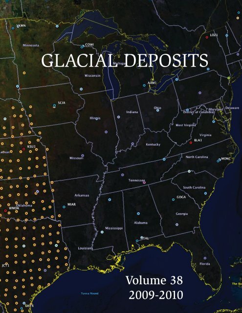
Cover: EarthScope features networks <strong>of</strong> sophisticated and carefully positioned seismic sensing devices<br />
that report automatically and frequently to data collection points via satellite telemetry. <strong>Illinois</strong> is in the<br />
path <strong>of</strong> an invasion by the brown dots, which represent positions, on a 75 kilometer grid, <strong>of</strong> the USArray.<br />
Some <strong>of</strong> the rolling array’s traveling seismometers will reside in <strong>Illinois</strong> for two years, beginning in 2011.<br />
The dot in <strong>Illinois</strong> underneath the name <strong>of</strong> the state is the location <strong>of</strong> HDIL, the broad band seismometer<br />
near Hopedale that Skip Nelson championed and now monitors. It is part <strong>of</strong> a 350 kilometer grid and will<br />
remain after the traveling array finally reaches the Atlantic and moves north to Alaska. For more<br />
information on all aspects <strong>of</strong> EarthScope, which is a program <strong>of</strong> the National Science Foundation, see<br />
www.earthscope.org. We thank EarthScope <strong>of</strong>ficials for allowing us to use the map and Press Technician<br />
David Blair at Printing Services for assistance with the cover.
TABLE OF CONTENTS<br />
Morgan Prairie<br />
From the Editor’s Desk<br />
Christmas Catastrophe<br />
Inside Front Cover<br />
iii<br />
iv<br />
EarthScope: Unlocking Secrets/Robert S. Nelson 1<br />
Building an Archive/Ge<strong>of</strong>frey J. Martin 3<br />
<strong>Geography</strong> Interns: Class <strong>of</strong> 2009 6<br />
A Gift to Earth/Ellen Dietz 10<br />
A Good Spring for <strong>Geography</strong> Club 14<br />
Route 66: Down through the Years/Anthony D’Anza 15<br />
Dos Cartógrafos en Chile/Michael D. Sublett (Editor) 20<br />
Midyear Commencement 31<br />
Student Awards 32<br />
First Majors and Graduate Students 33<br />
Conference Presentations 36<br />
Faculty and Staff Sketches 42<br />
Familiar Faces 55<br />
Yesteryears/Michael D. Sublett 56<br />
Mementos <strong>of</strong> Chile<br />
Inside Back Cover
FROM THE EDITOR’S DESK<br />
N<br />
owadays it happens all too <strong>of</strong>ten. I receive a request from the editor <strong>of</strong> a<br />
newsletter, or even a journal, asking that I agree to access their publication<br />
electronically and forgo the printed pages. They tell us they are hoping to reduce<br />
printing and mailing costs, speed up delivery to the reader, or become more in tune with<br />
the green times in which we live. Sometimes they want to send me a periodic email with<br />
the publication attached. Others tell me I can go to their Website and find the newsletter<br />
or whatever they may be relegating to the electronic world. I usually agree to such<br />
<strong>of</strong>fers, but I much prefer the printed predecessor to the modern marvel on my computer<br />
screen. My tendency is to skim the electronic whereas I like to sit and ponder the<br />
printed version. I have saved newsletter and journal runs for decades and wonder if<br />
their electronic successors will be there for readers and researchers to consult into the<br />
future. All <strong>of</strong> this prefatory prose brings me to <strong>Glacial</strong> <strong>Deposits</strong>. So far we are still going<br />
forward with the print format as our primary means <strong>of</strong> dissemination, although we do put<br />
an electronic version on the departmental Website. I appreciate the commitment <strong>of</strong><br />
departmental funds to print a couple hundred or so copies <strong>of</strong> the yearbook so I do not<br />
have to join other editors in asking readers to look for it online or in their email inboxes.<br />
Writing this column always signifies that we are approaching the end <strong>of</strong> a something I<br />
consider worth doing. Authors who agreed months or a year ago have fulfilled their<br />
promise to produce an article. Photographers have come through with images we can<br />
use. Conversations with authors have enabled me to corroborate claims and to<br />
eliminate here and enhance there, making the final text more readable (I hope). Dialog<br />
with photographers has helped me prepare captions that will allow the photos to stand<br />
as much on their own as possible. We have five solid articles for Volume 38 plus<br />
several photo segments and the usual series <strong>of</strong> departmental accomplishments<br />
(awards, presentations, sketches). “Yesteryears” is a short piece <strong>of</strong> prose that I enjoy<br />
researching and composing each year. This time the computer jumped out as common<br />
theme linking volumes from one, two, and three decades ago.<br />
Of course, I have to thank a host <strong>of</strong> helpers, such as the five authors: colleagues Skip<br />
Nelson, Jim Carter, and John Kostelnick; geographer Ge<strong>of</strong>frey Martin; and former<br />
students Ellen Dietz and Anthony D’Anza. Bill Morgan agreed to the use <strong>of</strong> his poem<br />
and to our traipsing around on his micro prairie. Others, including botanist Joseph<br />
Armstrong, assisted by answering questions as I did my fact checking. Deb Lescher<br />
prepared the text for press, and Jill Freund Thomas handled the graphics segments.<br />
Dave Malone made the funds available so we could avoid the aforementioned<br />
electronic replacement <strong>of</strong> the printed word. Photos, besides my own, came from Skip<br />
Nelson, Ge<strong>of</strong>frey Martin, Bill Morgan, Ellen Dietz, Larry Haigh, Mark McCleary, Anthony<br />
D’Anza, Andrew Nordstrom, Mark L<strong>of</strong>rano, Dagmar Budikova, Jim Carter, and John<br />
Kostelnick. We hope our readers find something <strong>of</strong> interest herein, and we are on the<br />
lookout for new material to fill the next volume. MDS<br />
iii
CHRISTMAS CATASTROPHE<br />
Christmas 2009 was a white one<br />
for those staying local, but it<br />
produced a campus tragedy. An<br />
artificial stone façade column at<br />
the northeast corner <strong>of</strong> Hovey Hall<br />
separated from the I‐beam that<br />
actually holds up the ro<strong>of</strong>, and<br />
part <strong>of</strong> it fell against the building.<br />
Stark Excavating sent a crew out<br />
on 25 December to remove the<br />
leaning section <strong>of</strong> stone. While<br />
operating an excavator, trying to<br />
remove the fallen column, Stephen<br />
D. White <strong>of</strong> Bloomington died<br />
when the column slipped and<br />
crushed him in the cab <strong>of</strong> his<br />
machine. Here, a day later, a crew<br />
was using another excavator to<br />
remove the disabled rig.<br />
On the same day that Stark<br />
removed its damaged excavator,<br />
other employees were strapping<br />
the remaining seven columns in an<br />
attempt to prevent further<br />
separation <strong>of</strong> stone from steel on<br />
the east side <strong>of</strong> the Hovey addition<br />
that went up in 1967.<br />
Later in the winter, a crew came<br />
back to chisel the terrazzo‐like<br />
material completely away from<br />
one additional column and replace<br />
the straps with metal plates, some<br />
<strong>of</strong> which were visible that day.<br />
Those plates and the two bare I‐<br />
beams were still evident in the<br />
summer <strong>of</strong> 2010.<br />
iv
EARTHSCOPE: UNLOCKING THE SECRETS OF<br />
THE NORTH AMERICAN CONTINENT<br />
By Robert S. Nelson<br />
I<br />
llinois State University is one <strong>of</strong> almost 100 schools participating in EarthScope. EarthScope<br />
is the largest continental geology project ever funded by the National Science Foundation<br />
(NSF), in partnership with the United States Geological Survey, and with the collaboration <strong>of</strong><br />
UNVACO Inc., Incorporated Research Institutions for Seismology (lRIS), Stanford University,<br />
and NASA. Its goal is to explore the geologic structure and evolution <strong>of</strong> the North American<br />
continent and understand the processes controlling earthquakes and volcanoes. EarthScope<br />
will look into Earth and reveal the inner workings <strong>of</strong> the planet much like the Hubble Telescope<br />
is revealing the early history <strong>of</strong> the universe.<br />
EarthScope began in 2003 with a five-year (2003-2008) budget <strong>of</strong> about $200,000,000 from the<br />
NSF Major Research Equipment and Facility Construction Account to construct four facilities<br />
(the infrastructure for major research thrusts). (1) The San Andreas Fault Observatory at Depth<br />
(SAFOD) is an instrumented borehole through the San Andreas Fault, just north <strong>of</strong> Parkfield,<br />
California. The tight seismometer and strain meter grids at Parkfield and SAFOD, make this part<br />
<strong>of</strong> the San Andreas Fault the most instrumented fault segment on the planet. (2) The Advanced<br />
National Seismic System consists <strong>of</strong> broad band seismometers located on a 350 kilometer grid.<br />
I was contracted by the United States Geological Survey to locate an appropriate location for<br />
one <strong>of</strong> these stations in 2005. Station HDIL was constructed in 2006 at Mackinaw River State<br />
Fish and Wildlife Area about 20 miles west <strong>of</strong> the <strong>Illinois</strong> State campus. Seismic data from this<br />
station go by satellite telemetry every 15 seconds to the United States Geological Survey<br />
Albuquerque Seismological Laboratory. I remain the local contact for the station. (3) The Plate<br />
Boundary Observatory consists <strong>of</strong> 875 ultrahigh resolution global positioning system stations.<br />
Each station’s position is continuously determined and reported by satellite telemetry to<br />
UNAVCO in Boulder, Colorado. Station HDIL is also part <strong>of</strong> the Plate Boundary Observatory.<br />
Data since the station went on line in 2006 indicate that the station is moving south 60 o west at a<br />
velocity <strong>of</strong> roughly 1.5 mm/y and is going down about 5.07 mm/y. The horizontal motion is<br />
consistent with the general counterclockwise rotation <strong>of</strong> the North American Tectonic Plate.<br />
There are two major hypotheses for the vertical motion: post-glacial isostatic adjustment or<br />
collapse <strong>of</strong> the aquifer beneath the station as water is withdrawn in seeps and springs in the<br />
valleys on either side <strong>of</strong> the station. (4) The USArray consists <strong>of</strong> 400 high quality broad band<br />
seismometers deployed on a 75 kilometer grid. These were first deployed in California, Oregon,<br />
and Washington along the coast in 2006 (the 100 th anniversary <strong>of</strong> the San Francisco<br />
Earthquake). Each seismometer remains in place for about two years and then is moved to a<br />
new location, just east in the grid. In this fashion the USArray is rolling across the United States.<br />
The actual location for the USArray stations in <strong>Illinois</strong> will be determined this summer and<br />
installed next year for the 200 th anniversary <strong>of</strong> the New Madrid Earthquakes. In 2014 the<br />
USArray moves to Alaska for the 50 th anniversary <strong>of</strong> the 1964 Alaska Earthquake (the second<br />
largest recorded earthquake).<br />
In addition to the science, EarthScope has an education and outreach component. We obtained<br />
a major Math and Science Partnership Grant from the U.S. <strong>Department</strong> <strong>of</strong> Education through<br />
the <strong>Illinois</strong> State Board <strong>of</strong> Education to conduct <strong>Illinois</strong> EarthScope, a workshop for teachers. A<br />
pilot two-week workshop was conducted for 18 teachers in late July and early August 2009 with<br />
follow-up weekend sessions in November and January. In addition to hearing presentations by<br />
Drs. Dunn, Malone, and Nelson and Mr. Shields and participating in field trips led by Drs.<br />
2
Malone and Nelson, the teachers tried out many teaching activities that they could take back<br />
into their classes.<br />
<strong>Illinois</strong> EarthScope is one <strong>of</strong> only three EarthScope teacher workshops in the country. One <strong>of</strong><br />
other workshops is in California. The third is in Oregon but is for teachers from both Oregon and<br />
Washington. I was an observer <strong>of</strong> one <strong>of</strong> the Saturday sessions <strong>of</strong> the Oregon-Washington<br />
workshop. EarthScope workshops provide the teachers with the background to teach plate<br />
tectonics, volcanoes, earthquakes, and tsunamis effectively. The EarthScope Education and<br />
Outreach Office at Oregon State University provides abundant teaching materials, and each<br />
teacher in one <strong>of</strong> the EarthScope workshops is included in a special email list-serve. Within two<br />
hours <strong>of</strong> a major event (big or important) earthquake or volcanic eruption, EarthScope teachers<br />
are provided a 10 to 12 slide PowerPoint presentation on the event that they can take right into<br />
class. This is a teachable moment. The <strong>Illinois</strong> EarthScope teachers used the 2010 Haitian<br />
Earthquake in their classes, and several teachers shared the presentation with other teachers in<br />
their building.<br />
We have selected teachers for the 2010 <strong>Illinois</strong> EarthScope Workshop. This workshop will<br />
feature a three-day field trip to the St. François Mountains in eastern Missouri to see part <strong>of</strong> the<br />
granite-rhyolite terrain that underlies the sedimentary rocks <strong>of</strong> <strong>Illinois</strong> and then across far<br />
southern <strong>Illinois</strong>. Planned field trip stops include a production blast at the Anna (<strong>Illinois</strong>) Quarry<br />
and looking at the mineralization associated with the Mississippi Embayment and the New<br />
Madrid Seismic Zone.<br />
Skip Nelson and <strong>Department</strong> Chair David Malone ran a field trip for the 2009<br />
EarthScope Workshop that included a stop (here) at Castle Rock State Park,<br />
south <strong>of</strong> Oregon, <strong>Illinois</strong>, on the right bank <strong>of</strong> the Rock River. Dr. Malone was<br />
speaking to them about the St. Peter Sandstone and why it is so strong.<br />
2
BUILDING AN ARCHIVE WITH SPECIAL REFERENCE<br />
TO THE LETTERS OF GEOGRAPHERS<br />
3<br />
By Ge<strong>of</strong>frey J. Martin<br />
F<br />
rom an earlier time, the writer wished to learn how American geographical institutions<br />
developed, what had been the mechanisms <strong>of</strong> growth, and at what point and under what<br />
circumstance had the whole evolved into a discipline poised on the threshold <strong>of</strong><br />
geographical science. Unfortunately, we did not have available a history <strong>of</strong> American<br />
geography. Your author wished to help change this state <strong>of</strong> affairs and decided to make a study<br />
<strong>of</strong> William Morris Davis, a most remarkable physical geographer. It was Davis who, in the<br />
1880s, conceptualized the origin <strong>of</strong> the discipline with his scheme <strong>of</strong> the cycle <strong>of</strong> erosion<br />
embracing the stages: youth, maturity, and old age. Under his tutelage there emerged a stream<br />
<strong>of</strong> what might be called human geographers. Davis, by the way, referred to human geography<br />
as ontography.<br />
So the plan constructed was to make studies <strong>of</strong> three <strong>of</strong> Davis’s finest students, Mark Jefferson,<br />
Ellsworth Huntington, and Isaiah Bowman. Jefferson specialized in the study <strong>of</strong> anthropography<br />
(the distribution <strong>of</strong> population); Huntington initially specialized in the effect <strong>of</strong> climate on human<br />
behavior (physiological climatology); and Bowman specialized on the individuality <strong>of</strong> regions<br />
(regional geography). These were the three fundamental designs for study deriving from the<br />
Davisian urging for some <strong>of</strong> his students to develop a human geography. This author published<br />
the resultant three books concerning the contributions <strong>of</strong> Jefferson, Huntington, and Bowman<br />
consecutively in 1968, 1973, and 1980.<br />
Each <strong>of</strong> these books was the product <strong>of</strong> reading publications <strong>of</strong> the particular author, and<br />
additionally their correspondence. In days now gone by, letter writing was a very important part<br />
<strong>of</strong> both academic and intellectual life. And usually it is in the correspondence that the life and<br />
thought <strong>of</strong> the scholar will stand revealed. There embryonic thoughts and feelings, frequently<br />
never to be published, may be shared with another, especially if the letter writers exchanged<br />
correspondence throughout a lifetime. Two <strong>of</strong> the best examples <strong>of</strong> this extended<br />
correspondence are Mark S. W. Jefferson-Isaiah Bowman, 1901-1949, and Richard E. Dodge-<br />
Albert P. Brigham, 1892-1932; each <strong>of</strong> these exchanges produced more than two hundred<br />
letters. And so one goes in quest <strong>of</strong> correspondence; such deposits may be found in a library, a<br />
geographical society, a nationally known repository, or a private holding. Warning: Be sure to<br />
correspond with the archivist in advance to learn <strong>of</strong> particular details, because in some<br />
instances it is required that the seeker have permission from next <strong>of</strong> kin. And in other instances,<br />
there might be a period <strong>of</strong> closure concerning the holding or part there<strong>of</strong>, which is quite<br />
frequently 25 or 50 years after a death.<br />
The quest for, and examination <strong>of</strong>, these holdings in far-flung deposits is an integral part <strong>of</strong> the<br />
undertaking. Accomplishment is hard won, and can otherwise be costly in time and money. Yet<br />
this is where the data reside. This pursuit is both footing and foundation <strong>of</strong> our field <strong>of</strong> learning.<br />
It is here where the untold history <strong>of</strong> our field resides. And study <strong>of</strong> the archives may have<br />
practical applications. For example, some archivists were employed in the Enigma Project <strong>of</strong><br />
World War II; others who have studied archival matters in geography have functioned as<br />
witnesses in a courtroom (e. g., Bowman in the Red River case) and yet others have parsed<br />
disputation <strong>of</strong> boundary squabbles by exploiting archival data, e. g., Lawrence Martin. And, as<br />
Archivist for the Association <strong>of</strong> American Geographers since 1986, I have received some 230<br />
inquiries concerning a variety <strong>of</strong> matters relating to the past, approximately 70 percent <strong>of</strong> which
have been answered from archival sources. Of much interest are extended statements from<br />
persons such as Mabel H. Ward (Isaiah Bowman’s secretary for 13 years). She wrote, “In the<br />
thirteen years that I worked for [Isaiah Bowman] my accumulated notebooks filled the space <strong>of</strong><br />
one deep shelf in my closet. I enjoyed taking down and transcribing the occasional long letters<br />
he wrote to pr<strong>of</strong>essional correspondents” (statement <strong>of</strong> 4,000 words, Mabel H. Ward-G. J.<br />
Martin, December 27, 1973). Details followed in her statement about his visitors, and about her<br />
role first as Stefansson’s secretary, then Ogilvie’s secretary, and finally Bowman’s secretary, the<br />
sort <strong>of</strong> detail that with the passing <strong>of</strong> the person in question becomes priceless documentation.<br />
In the last 51 years, the author traveled to more than a dozen countries and visited 135 archival<br />
deposits, each archive ranging in size from a few dozen to many thousands <strong>of</strong> pages. Most <strong>of</strong><br />
these letters were handwritten; hence copies <strong>of</strong> them were not maintained by the authors.<br />
Typewritten letters became more popular from the teens though abundant handwritten<br />
correspondence continued to the 1940s and 1950s. To view these letters, one needs to travel<br />
usually to their place <strong>of</strong> destination. Since (in the period 1870-1960 on which my current<br />
research focuses) most <strong>of</strong> these letters were sent to Great Britain, Germany, France, Sweden,<br />
and many destinations throughout the United States, that is where one must visit to read and<br />
assay the letters. And since a postal system was not a reality in the United States until 1847,<br />
exchange <strong>of</strong> letters nationally and internationally was a clumsy and lengthy matter prior to that<br />
time. With development <strong>of</strong> postal systems came letter writing and the transport and sharing <strong>of</strong><br />
scientific thought. A word concerning privately held collections is necessary. One cannot<br />
anticipate circumstances. Your author located the diary <strong>of</strong> the deceased Mark Jefferson—one<br />
page at a time—under a large coal heap in the basement <strong>of</strong> Jefferson’s house in Ypsilanti,<br />
Michigan. Some sheets <strong>of</strong> the diary were located in his barn. Your author put these together and<br />
otherwise edited the diary (some pages have been permanently lost) and published it with<br />
Edwards Brothers, Ann Arbor, Michigan. Jefferson was the chief cartographer for the American<br />
Commission to Negotiate Peace at Paris, 1918-1919. Now, a copy <strong>of</strong> this diary resides in the<br />
National Archives, Washington, D.C.; and scholars from various disciplines exploit its content.<br />
Other private holdings may be restricted in whole or part.<br />
Once correspondence is acquired, a collection begins. Keep it dry, preferably out <strong>of</strong> sunlight,<br />
and in an order suited to your mentality. Then a study site, a powerful magnifying glass, the<br />
ability to read erratic abbreviations and difficult handwriting (and writing north-south and eastwest<br />
on the same page!), and the ability to read French and German (especially script that<br />
Germans today are unable to read, as script was invariably used prior to about 1900) are all<br />
valuable assets in the quest for comprehension. Incidentally, you will not be able to find these<br />
letters via computer, though you may be able to secure data about authors, and possibly<br />
“Finders Guides” to some collections. However, beware <strong>of</strong> error if you are going to use the<br />
machine. People working in the history <strong>of</strong> geographical thought sometimes copy data from the<br />
computer; and matters including names <strong>of</strong> persons, dates, and titles <strong>of</strong> articles may be incorrect.<br />
This collection <strong>of</strong> incorrectness may then be transferred into publications, whereby the whole<br />
metastasizes and the mistake may become the norm. One final matter concerns the dimensions<br />
<strong>of</strong> collecting. My holding includes roughly 51,000 sheets, by what is conservative count, all<br />
stored in my dwelling. This collection <strong>of</strong> papers consumes a very large amount <strong>of</strong> space.<br />
Several filing cabinets have been filled, and book cases hold many photocopy sheets in threering<br />
binders. All holdings need to be named and numbered, and identified as to source. In my<br />
case, some 20-22 percent is the product <strong>of</strong> my own correspondence.<br />
Yet it must always be remembered that quantity is not the index <strong>of</strong> archival worth. Photographs<br />
(identifications carefully added to the back <strong>of</strong> same are vital) are also a vital part <strong>of</strong> such a<br />
collection; in this genre the history <strong>of</strong> geography is quite weak. One might write letters to the<br />
4
contemporaries <strong>of</strong> the key figure, the society, department, or the philosophy studied. Such<br />
persons may include fellow geographers or other disciplinarians, previous students, relatives,<br />
etc. My richest haul <strong>of</strong> such letters came from geographers and those interested in matters<br />
geographic born in earlier years from 1880 to 1910 and included, for example, Ruth Baugh, S.<br />
C. Gilfillan, Owen Lattimore, John Leighly, Raye R. Platt, Carl O. Sauer, J. Russell Smith,<br />
Vilhjalmur Stefansson, T. Griffith Taylor, E. Van Cleef and John K. Wright. From the United<br />
Kingdom valuable correspondents included R. P. Beckinsale, W. Gordon East, and Arnold J.<br />
Toynbee; from Australia correspondents included Marcel Aurousseau and Oskar Spate, and<br />
there were many dozens more. And here one must make reference to Maynard Weston Dow’s<br />
Geographers on Film, the equivalent <strong>of</strong> “talking letters”—which includes some 550 films<br />
featuring interviews with individual geographers, the filming <strong>of</strong> panels, papers at national<br />
meetings, and AAG presidential addresses.<br />
One builds a collection and in so doing one cannot avoid learning multitudinous details and the<br />
genesis <strong>of</strong> large, sweeping thought contributory to evolution <strong>of</strong> the field. Whenever possible one<br />
copies (by machine) significant correspondence; in the late 1950s frequently machine copying<br />
was not available, and so one copied by hand. Today photocopying is provided by assistants <strong>of</strong><br />
the curator, though some holdings permit the use <strong>of</strong> cameras to accomplish the same ends. In<br />
any case one needs to have studied the given task as much as possible from secondary<br />
sources, or else once inside a large archival holding one will not be able to select thoughtfully<br />
sheets that the investigator desires to have copied. Finally, one needs to do something<br />
constructive with the archival materials accumulated. In my case, the current task is to complete<br />
the writing <strong>of</strong> a history <strong>of</strong> United States geography, circa 1870-1960.<br />
EDITOR’S NOTE: Ge<strong>of</strong>frey Martin presented the Distinguished Geographer Lecture at <strong>Illinois</strong><br />
State University in the spring <strong>of</strong> 2009. A native <strong>of</strong> England, he is Pr<strong>of</strong>essor Emeritus <strong>of</strong><br />
<strong>Geography</strong> at Southern Connecticut State University and lives in Woodbridge, Connecticut.<br />
Ge<strong>of</strong>frey Martin likes to immerse himself in his work. To<br />
some, his home might seem cluttered. To him, there is only a<br />
modicum <strong>of</strong> disorder in his archival treasury.<br />
5
GEOGRAPHY INTERNS: CLASS OF 2009<br />
Mark L<strong>of</strong>rano (left) and<br />
Andrew Nordstrom were<br />
our fourth and fifth<br />
interns to serve as<br />
environmental educators<br />
at Wild Bear Center for<br />
Nature Discovery, in<br />
Nederland, Colorado.<br />
Wild Bear, having<br />
reached the five‐intern<br />
plateau, received a<br />
certificate <strong>of</strong> appreciation<br />
in 2009 from the<br />
<strong>Department</strong> for<br />
longstanding cooperation<br />
with our internship<br />
program.<br />
The City <strong>of</strong> Rock Island,<br />
<strong>Illinois</strong>, takes its<br />
facilities seriously.<br />
Intern Alex Hutchins<br />
(left) helped supervisor<br />
Randy Tweet and the<br />
rest <strong>of</strong> Public Works<br />
keep track <strong>of</strong> signs and<br />
such, throughout the<br />
summer <strong>of</strong> 2009, with<br />
GPS and GIS<br />
technology.<br />
6
Libby Townley (center) was<br />
<strong>Geography</strong>’s third summer<br />
intern at the Greater Peoria<br />
Sanitary District. District<br />
Engineer Tim Leach (right)<br />
has played an advisory role in<br />
the experiences <strong>of</strong> all three<br />
interns. Directly supervising<br />
Libby’s GIS work was<br />
Shubhada Savant (left).<br />
Matt Kline (left)<br />
found an excellent<br />
internship only<br />
five minutes by<br />
vehicle from his<br />
parental home, a<br />
few miles south <strong>of</strong><br />
Joliet, at the Forest<br />
Preserve District<br />
<strong>of</strong> Will County.<br />
Helping oversee<br />
Matt’s GIS and GPS<br />
duties was Sam<br />
Hildebrand.<br />
The National Atmospheric<br />
Deposition Program, directed by<br />
David Gay (right), gathers<br />
information on precipitation<br />
chemistry and operates out <strong>of</strong> the<br />
facilities <strong>of</strong> the <strong>Illinois</strong> State Water<br />
Survey, in Champaign. Intern Nate<br />
Chott (left) spent his time there<br />
manipulating huge data sets in a GIS<br />
environment.<br />
7
ADDITIONAL GEOGRAPHY INTERNS<br />
McHenry County’s<br />
conservation district is<br />
one <strong>of</strong> a handful <strong>of</strong> such<br />
entities in <strong>Illinois</strong>. Nick<br />
Kirk (left) was our fifth<br />
intern there, so his<br />
supervisor, Perry<br />
Weborg (right),<br />
received our certificate<br />
<strong>of</strong> appreciation in 2009<br />
on behalf <strong>of</strong> the<br />
District.<br />
Schaumburg’s Spring<br />
Valley Nature Center is a<br />
logical internship site for<br />
Chicagoland majors who<br />
want to live at home and<br />
work in environmental<br />
education. Intern Sarah<br />
Prociuk (center) spent her<br />
summer mornings helping<br />
Mary Rice (right) educate<br />
children about nature and<br />
her afternoons under the<br />
direction <strong>of</strong> Kelly Schultz<br />
(left) performing site<br />
restoration and other<br />
outdoor duties.<br />
Micah Williamson (right)<br />
interned in 2001 for his<br />
<strong>Illinois</strong> State degree at<br />
Tri‐County Regional<br />
Planning in Peoria. Now<br />
he is in a position as GIS<br />
Director for Peoria County<br />
to bring in interns, like his<br />
first from <strong>Illinois</strong> State,<br />
Sarah Semple (left). Sarah<br />
worked much <strong>of</strong> the<br />
summer updating<br />
property boundaries in<br />
the GIS files <strong>of</strong> tax parcels.<br />
8
Our main contact for<br />
internships in the area<br />
around Barrington,<br />
<strong>Illinois</strong>, is the<br />
Barrington Area<br />
Council <strong>of</strong><br />
Governments (BACOG).<br />
Joy Hoeffler (right), the<br />
GIS specialist for<br />
BACOG, helped us place<br />
intern Tom Pink (next<br />
to Joy) with Greg<br />
Summers (left) and the<br />
Village <strong>of</strong> Barrington.<br />
Between Greg and Tom<br />
posed one <strong>of</strong> the<br />
decorated horses that<br />
participated <strong>of</strong> a fundraising<br />
endeavor by the<br />
local United Way.<br />
State Farm Insurance goes<br />
through a lot <strong>of</strong> three‐ring<br />
binders at its Bloomington<br />
headquarters and other local<br />
sites. Intern Walter Allen, part <strong>of</strong><br />
State Farm’s environmental<br />
program in the summer <strong>of</strong> 2009,<br />
had an idea about making the<br />
binders available for giveaways<br />
to school kids, which would also<br />
mean keeping the binders out <strong>of</strong><br />
the landfill.<br />
Midewin National Tallgrass<br />
Prairie, part <strong>of</strong> the U.S.<br />
Forest Service, occupies<br />
land once dedicated to the<br />
manufacture <strong>of</strong> ordnance<br />
for the U.S. Army, along old<br />
Route 66, north <strong>of</strong><br />
Wilmington, <strong>Illinois</strong>. Intern<br />
Zack Hudak performed<br />
many outdoor duties over<br />
the summer, but one <strong>of</strong> his<br />
favorites was operating the<br />
skid steer to move mulch,<br />
gravel, and soil.<br />
9
A GIFT TO EARTH<br />
By Ellen Dietz<br />
A<br />
dickcissel watches. A green heron croinks. The wind carries the sound <strong>of</strong> tires on<br />
pavement. We stand in a fledgling prairie emerging from an old farm field, bounded by<br />
highway and windbreaks.<br />
In this field are the hopes <strong>of</strong> Dr. Bill Morgan, who has begun the task <strong>of</strong> restoring a fallow<br />
agricultural field to its original cover. In the spring <strong>of</strong> 2009, with the help <strong>of</strong> several friends, a<br />
Bison seed drill, and a borrowed tractor, he set about turning the acreage back to its prairie<br />
roots. The land has lain fallow for several years under the auspices <strong>of</strong> the federal CRP, or<br />
Conservation Reserve Program, sporting timothy, brome, and fescue grasses. It had cover, yes,<br />
but not native cover.<br />
According to the Natural Resources Conservation Service website, “The Conservation Reserve<br />
Program reduces soil erosion, protects the Nation's ability to produce food and fiber, reduces<br />
sedimentation in streams and lakes, improves water quality, establishes wildlife habitat, and<br />
enhances forest and wetland resources. It encourages farmers to convert highly erodible<br />
cropland or other environmentally sensitive acreage to vegetative cover, such as tame or native<br />
grasses, wildlife plantings, trees, filter strips, or riparian buffers.” In keeping with this program,<br />
Morgan has maintained the grass waterways, wind blocks, and grass cover. But it was not<br />
enough for him.<br />
Morgan decided the best action was to plant a prairie on the property. It went into the ground as<br />
seeds, taken from McLean County genotypes, or plants that have adapted to local conditions,<br />
so they are suited to the local soil and climate with the resistance, immunities, and strengths<br />
that will enable them to assimilate quickly into new prairie. He planted a plethora <strong>of</strong> forbs and<br />
four indomitable grasses. Gathering their strength in the soil are these:<br />
prairie dropseed, Indian grass, Canada wild rye, and little bluestem, and a wealth <strong>of</strong><br />
color to come in prairie blazing star, bundle flower, silky prairie clover, compass plant,<br />
prairie coneflower, purple coneflower, golden alexander, stiff goldenrod, partridge pea,<br />
prairie dock, rosin weed, black-eyed susan, sweet black-eyed susan, showy tick trefoil,<br />
rattlesnake master, false sunflower, wild quinine, bee balm, foxglove, and cup plant.<br />
Morgan’s seeds had already taken hold in the first few months. He was counseled to expect<br />
weeds and not much else the first year. As expected, the foxtails and other weeds dominated<br />
the property, but Indian grass and little bluestem were already flowering by the end <strong>of</strong> the first<br />
summer, producing seeds <strong>of</strong> their own.<br />
What is the point Morgan sees himself as a land steward, and merely following the CRP was<br />
not enough. Better than timothy and fescue, native grasses put their roots deeply into the soil,<br />
fixing nitrogen and creating soil wealth. He wanted to add to the diversity <strong>of</strong> plants on the<br />
landscape, not merely be content with a slim variety <strong>of</strong> weeds. He wanted to see more wildlife,<br />
support a greater variety <strong>of</strong> critters, and have the satisfaction that another little corner <strong>of</strong> the<br />
Midwest was returned to its pre-agricultural state. All said, it really boiled down to ethics.<br />
Morgan knows that little <strong>of</strong> the original prairie remains, and he wanted to be part <strong>of</strong> returning<br />
what he could.<br />
10
The prairie plot, itself, is inside the bounds <strong>of</strong> the larger property, separated from the<br />
surrounding acreage by windbreaks, a pond, and roads. Morgan calls this acreage his “gift to<br />
Earth.” It seems, though, that he is receiving the greater gift, as various creatures stop in to visit<br />
on their migrations north and south, or build a nest to claim this land as home. Part <strong>of</strong> his intent<br />
was to create wildlife habitat; he does not have to wait years to see this dream come to fruition,<br />
as it is already acting as a refuge in a seasonal sea <strong>of</strong> corn and soybeans. Part <strong>of</strong> his intent in<br />
planting this plot was to honor Earth in conjunction with the rules <strong>of</strong> the federal Conservation<br />
Reserve Program; his part in planting native grasses and forbs trumps merely leaving the<br />
ground untilled. Mostly, though, he wanted to see what would happen; he is already seeing the<br />
results, as grasses take hold and shoot their seeds two feet high toward the light and wind the<br />
very first summer, an unexpected marvel and testament to the strength <strong>of</strong> the soil and wisdom<br />
<strong>of</strong> using local genotypes.<br />
Already, he has seen quail and pheasant, bees, and meadowlarks. With the pond nearby, the<br />
property gets a wealth <strong>of</strong> migratory species, including water birds such as gadwalls; northern<br />
shovelers; and even a bittern, a rarity among these parts. The riparian zones favor muskrat,<br />
beaver, and deer; and the pond is stocked with several different species <strong>of</strong> fish. He installed a<br />
purple martin house, which hosted nearly 50 martins in 2009. He also installed a bluebird house<br />
a young friend built, which has yet to attract residents; but they have high hopes for the next<br />
nesting season. As the prairie grows stronger through the years, it will host an even wider<br />
variety <strong>of</strong> wildlife, which is part <strong>of</strong> Morgan’s hopes for the property.<br />
“To mow or not to mow” was the first year’s most pressing question. On the one hand, mowing<br />
would keep the weeds at bay, giving the tender new shoots a chance to establish themselves<br />
more quickly. On the other hand, the prairie grasses and forbs are strong, resilient plants,<br />
capable <strong>of</strong> making it on their own. He decided to exercise patience, letting the prairie develop in<br />
its own time, without the aid <strong>of</strong> mowers. This means that his work for year one was completed<br />
with the act <strong>of</strong> seeding. Now the prairie is on its own, and he has the confidence that letting it<br />
develop in its own way is the best course <strong>of</strong> action.<br />
Morgan’s background is not ecology, or biology, or agriculture. He is a retired <strong>Illinois</strong> State<br />
English pr<strong>of</strong>essor, with a deep love <strong>of</strong> the land. He derives great enjoyment from connecting<br />
with the land, as a fisherman, a bird watcher, or a philosopher, and now as the steward <strong>of</strong> his<br />
own little prairie. His control <strong>of</strong> the property is not really control at all; once the seeds were<br />
properly planted, the prairie assumed control, and he is content to surrender to the wisdom <strong>of</strong><br />
native plants.<br />
Maintenance <strong>of</strong> the surrounding land helps the prairie by shielding harsh winds, providing cover<br />
for the wildlife that will fertilize and pollinate it, and controlling water to prevent the still-delicate<br />
soil from washing away. On the surrounding property he has planted a three-tiered windbreak <strong>of</strong><br />
deciduous trees, conifers, and shrubs, and maintained the grass waterways. All <strong>of</strong> this helps to<br />
protect and nurture the prairie growing within its midst.<br />
So what is next For Morgan, it is the peace <strong>of</strong> knowing that he has given something back to the<br />
land; the contentment <strong>of</strong> leaving something <strong>of</strong> value to his heirs; and the enjoyment <strong>of</strong> watching<br />
the seasons nurture, stress, and strengthen the prairie. It is a labor <strong>of</strong> love. It is a tangible prayer<br />
for the future. It is an island <strong>of</strong> tranquility for his feathered and furred neighbors. It is the comfort<br />
<strong>of</strong> doing the right thing. Whether it lasts five years or 50, it is the right thing now and for the<br />
foreseeable future.<br />
11
The mind’s eye sees the prairie in years to come: gently nodding rye, heavily seeded Indian<br />
grass, and the spreading fingers <strong>of</strong> little bluestem, shooting up among the bright yellows <strong>of</strong><br />
compass plants, cup plants, stiff goldenrod, and black-eyed susans, tempered by the sweeter<br />
yellow <strong>of</strong> partridge pea, the lavenders <strong>of</strong> blazing stars and showy tick trefoil, the white globes <strong>of</strong><br />
bundle flower, the pinks and purples <strong>of</strong> foxglove, the branching blooms <strong>of</strong> silky prairie clover, the<br />
prickly balls <strong>of</strong> rattlesnake master, and the reds and purples <strong>of</strong> bee balm. The prairie will hum<br />
with life, from the insects feeding on bud, leaf, and nectar, to the mice who scratch and run in<br />
tunnels among the grasses and the coyotes who pounce upon the less vigilant ones. It will sing<br />
with the trills <strong>of</strong> meadowlarks and the melodies <strong>of</strong> bluebirds and song sparrows. Pheasants will<br />
wander the perimeters and red-winged blackbirds will bow the seed heads as they stake their<br />
territorial claims. The winds will whip the prairie to a frenzy and cool rains will quench the<br />
ground. The seasons will change, the prairie will grow, and Morgan will have the gift to Earth he<br />
has so wanted.<br />
EDITOR’S NOTE: Ellen Dietz has authored numerous items for <strong>Glacial</strong> <strong>Deposits</strong>. She works as<br />
a grant writer for Project Oz in Bloomington and holds the master’s in <strong>Geography</strong> from <strong>Illinois</strong><br />
State. Ellen is an avid nature observer and photographer. See the inside front cover for some <strong>of</strong><br />
her photography.<br />
Morgan Prairie came into existence at the end <strong>of</strong> May 2009, as Tim Bailey<br />
(left) used a small Case IH tractor and a Truax seed drill to plant the<br />
grasses and flowers. Truax Manufacturing features three charging bison<br />
as its company logo, hence the Bison nickname for its products. Bill<br />
Morgan is between tractor and drill. They borrowed the drill from the<br />
Normal <strong>of</strong>fice <strong>of</strong> the Natural Resources Conservation Service.<br />
12
Restoration<br />
To make a prairie it takes a clover and one bee,<br />
One clover, and a bee,<br />
And revery.<br />
The revery alone will do,<br />
If bees are few.<br />
--Emily Dickinson<br />
These slick little seeds, black-browngrey<br />
on my fingers, promise rattlesnake<br />
master, coneflowers yellow and purple,<br />
blue aster, compass plant, tick<br />
trefoil, bundleflower, partridge<br />
pea—some <strong>of</strong> the dozen native<br />
forbs we’re mixing with green kelp meal<br />
in a 5-gallon bucket. Another holds<br />
fluffy grasses—little bluestem, wild rye,<br />
prairie dropseed, indian—stirred into pinkish-<br />
brown Azomite before we pour<br />
both tubs into the bins <strong>of</strong> the Bison<br />
seed drill harnessed behind the brightred,<br />
borrowed tractor. The project<br />
today is to press these antique names,<br />
sturdy and eloquent, back into the narrative<br />
<strong>of</strong> this ancient, glacial soil, whose tale<br />
for a hundred years has been spoken in corn<br />
and beans, in brome, timothy, fescue—<br />
alien tongues <strong>of</strong> a vast, agricultural epic,<br />
On planting day, Bill Morgan kept a<br />
close eye on the process. Note the<br />
plastic sleeves around young trees in<br />
the background, sleeves that provide<br />
some protection against animal browse.<br />
one acre <strong>of</strong> which, about a sentenceworth,<br />
we’re rewriting this afternoon:<br />
our small gift <strong>of</strong> color, lyric voice<br />
restored to the muffled, patient earth.<br />
--Bill Morgan<br />
EDITOR’S NOTE: Bill Morgan was a member <strong>of</strong> the <strong>Illinois</strong> State University English <strong>Department</strong><br />
from August <strong>of</strong> 1969 until his retirement in June <strong>of</strong> 2000. Although he taught a variety <strong>of</strong><br />
courses, he especially committed to the importance <strong>of</strong> poetry. His prairie came to our attention<br />
when he sent us a poem about it. We reprint that poem above, with the poet’s permission.<br />
13
A GOOD SPRING FOR GEOGRAPHY CLUB<br />
Programmatic clubs fluctuate in membership and effectiveness as students (and sponsors) come and<br />
go. <strong>Geography</strong> Club, under the sponsorship <strong>of</strong> Pr<strong>of</strong>essor John Kostelnick and leadership <strong>of</strong> Co‐<br />
Presidents Kevin Gorell and Mark McCleary, had a nice thing going in the spring <strong>of</strong> 2010. On 30 March<br />
they cleaned up the club’s adopted park and later that day successfully defended the intramural<br />
bowling title. Then on 16‐17 April, the club was out on the Quad to participate in Relay for Life.<br />
Club members Ryan Weaver (left) and Mike<br />
Johnson had their rubber gloves and garbage<br />
bag ready to clean up Underwood Park in the<br />
southern part <strong>of</strong> Normal on a warm spring<br />
afternoon.<br />
Larry Haigh hoisted the symbolic trophy (an<br />
old bowling ball glued to a rock [not visible])<br />
after <strong>Geography</strong> Club defeated <strong>Geology</strong> Club<br />
and retained the prize. Larry was the chief<br />
organizer <strong>of</strong> <strong>Geography</strong> Club’s Relay for Life<br />
participation and received a departmental<br />
letter <strong>of</strong> commendation for his outstanding<br />
effort.<br />
Relay for Life is a big campus event with<br />
groups like <strong>Geography</strong> Club soliciting<br />
donations and then spending the night huddled<br />
for warmth and taking turns walking the Quad<br />
circuit between six in the evening and six the<br />
next morning. Prior to walking they posed for<br />
this photo. From the left, were Larry Haigh,<br />
Justin Padaoan, Joe Wojtas, Kevin Gorell, Ryan<br />
Weaver, Mike Clementz, Christina Woloshyn,<br />
Mark McCleary, Allen Cooksey, and Stephen<br />
Holt.<br />
14
ROUTE 66: DOWN THROUGH THE YEARS<br />
By Anthony D’Anza<br />
M<br />
y first recollection <strong>of</strong> United States Highway (Route) 66 goes back to my college days<br />
at <strong>Illinois</strong> State Normal; that is what they called it back ‘62. I traveled from Bellwood (a<br />
Chicago suburb) to school several times every year <strong>of</strong> college, about 120 miles. There<br />
were always important reference points as we drove along to let us know how far we<br />
had gone and how long it would take to the next point, points like the Des Plaines River and<br />
Coal City with its earth mounds shaped like Diamondhead in Hawaii. Route 66 would take us to<br />
Joliet and then through towns such as Dwight, Odell, Pontiac, Chenoa, Lexington, Towanda,<br />
and finally into Normal. Dwight had the C<strong>of</strong>fee House, which was about halfway to Normal or an<br />
hour away. Odell had a gas station and a place where tires were fixed as an old German<br />
shorthair dog watched. Pontiac had the prison and the Log Cabin Café, famous for pancakes.<br />
Chenoa was the crossroads <strong>of</strong> 66 and Route 24, and had signs for Meramec Caverns in<br />
Missouri. The endless rows <strong>of</strong> corn were prominent as you reached and saw the grain towers at<br />
Lexington. Then Towanda always had state police hovering for speeders.<br />
Sometimes we would drive down the even older version <strong>of</strong> Route 66, to see towns like Gardner,<br />
Braidwood, Wilmington, and Godley. Many <strong>of</strong> these towns had some old buildings with ads and<br />
signs along the way, like the Burma Shave signs. Gardner had the Riviera roadhouse.<br />
Wilmington had the Launching Pad, a restaurant with a big tall Gemini Giant. Braidwood had the<br />
Polka-a-Dot Drive In and statues <strong>of</strong> Elvis, Marilyn Monroe, James Dean, and Betty Boop.<br />
Route 66 had some old parts and newer parts, as the highway system was being transformed to<br />
the Interstate System. In the 1950s, the Interstate system was promoted and authorized by<br />
President Eisenhower. Much <strong>of</strong> the country became a crisscross <strong>of</strong> new highways to allow<br />
better movement <strong>of</strong> goods from coast to coast and north to south.<br />
I have made the trip west a half dozen times on Route 66 past St. Louis. Each time there were<br />
side trips that we took. Sometimes the destination was for a purpose; sometimes it was for<br />
adventure. In most cases, it was for the interest <strong>of</strong> the highway and what was along the way as<br />
we traveled west. This reflective essay is about my long-running and affectionate affair with 66.<br />
I will begin at the original starting point, Lou Mitchell’s restaurant in Chicago. At a recent<br />
seminar at the Oak Park Library, I learned that many people started at this point, though<br />
Buckingham Fountain is for some the traditional starting point as it is the farthest point east.<br />
Dining at Lou Mitchell’s is still a quaint experience, with its 1950s styles dining area, not much<br />
room, and greasy food.<br />
Traveling south and west down Ogden Avenue you come to the Castle Car Wash. According to<br />
brochure, it was built by Al Capone. It was just one <strong>of</strong> the many attractions along the route.<br />
Down the road is Castle Buick where I bought my first Buick, a great vehicle for cruising the<br />
Route.<br />
In Countryside was the Wishing Well Motel, where many <strong>of</strong> the big bands would stay when they<br />
came in town to play, usually at the Willowbrook Ballroom, on Archer Avenue, in Willow Springs.<br />
Also in that area was the Chicken Basket, famous for its cuisine <strong>of</strong> chicken, fries, coleslaw, and<br />
a drink since the 1930s.<br />
15
On the way to Joliet, you would see the many signs for White Fence Farm. White Fence also<br />
was a place for chicken, fries, vegetable, and a drink; but it was a little classier than the Chicken<br />
Basket and had seating in different rooms. Around the grounds were a farm-like decor and<br />
some animals for kids to pet or learn about through practical experience.<br />
There were three major museums I visited along the Mother Road. Downtown Joliet had a good<br />
museum with videos about most attractions along old Route 66. Right down the street was the<br />
Rialto Theatre, which has been restored. Elk City, Oklahoma, had artifacts and many souvenirs<br />
<strong>of</strong> Route 66 along with an old car and Native American craft work such as dolls and totem poles.<br />
This museum claimed to be the Official Route 66 Museum and one <strong>of</strong> the biggest. The one in<br />
Clinton, Oklahoma, was very good with souvenirs, pictures, refreshments, and lodging nearby.<br />
Every stop had its own theme centered around Route 66 and nearby attractions. Just recently<br />
built is the Abraham Lincoln Presidential Museum, which is a must see, along with Shea’s Gas<br />
Station Museum, down old Route 66 in Springfield, <strong>Illinois</strong>.<br />
Heading towards St. Louis, you came across little towns that now are obscure due to the new<br />
interstates. One curious place was Henry’s Ra66it Ranch in Staunton, <strong>Illinois</strong>. Many truckers<br />
and collection enthusiasts would see this Route 66 memorabilia stop. Just down the road was<br />
Litchfield, where we would stop at a smorgasbord restaurant on our way to ballgames or<br />
headed down south towards southern <strong>Illinois</strong>. Someone told me that it was called the Ariston<br />
Café. I now pick up a business card every time I stop, just to remind me <strong>of</strong> the name.<br />
Beyond Springfield, Missouri, there is Joplin, Missouri, a quaint little town along the Route 66<br />
trail. Then, as you drive westward, you come to the border with Kansas. A stretch <strong>of</strong> road for 13<br />
miles in the very southeast corner <strong>of</strong> Kansas is part <strong>of</strong> Route 66. The route is labeled by signs<br />
on the pavement, which becomes very narrow. On this short stretch is a Texaco gas station that<br />
is now an exhibition building for the segment <strong>of</strong> 66 in Kansas. Every year they hold a 13 mile<br />
half marathon centered on this gas station and the border. There are a number <strong>of</strong> very old and<br />
narrow bridges on this route.<br />
As you leave Kansas, you come to Commerce, Oklahoma, the former home <strong>of</strong> Mickey Mantle,<br />
the deceased but still famous outfielder <strong>of</strong> the New York Yankees. It is significant to me for I<br />
love baseball and came across this town by accident. The route travels through Oklahoma and<br />
winds around little towns that are now run-down and tattered because <strong>of</strong> the new routing down<br />
the Will Rodgers Turnpike. The land is dry and has scattered oil pumps along the way with<br />
cattle grazing the rugged land. However, one spot that stands out on the Turnpike is<br />
Claremore, the home town <strong>of</strong> Will Rogers. It has a museum and the home <strong>of</strong> the philosopher<br />
and political humorist. I always enjoyed his wit and humor. Into Oklahoma City, you will find the<br />
memorial <strong>of</strong> the Alfred P. Murrah Federal Building. It is not old Route 66, but is very impressive<br />
attraction on the way west on Interstate 40. At one time, Oklahoma City was filled with oil<br />
derricks, and hosts the Cowboy Hall <strong>of</strong> Fame.<br />
Heading towards Texas is a long stretch <strong>of</strong> flat land with hardly any trees and occasional rivers<br />
crossing the route. Route 40 parallels what was once Route 66. The city <strong>of</strong> Amarillo springs up<br />
out <strong>of</strong> nowhere. The Big Texan is a steak house in Amarillo that has signs as you come in all<br />
over the highway. If you can eat 72 ounces <strong>of</strong> steak in one hour, it is free. They put you up on a<br />
stage with your own table, and others are watching you eat the steak. Many have tried, but<br />
many have failed. Amarillo also has a lot <strong>of</strong> truck traffic and a multitude <strong>of</strong> motels with<br />
interesting rates and attractions. Just out <strong>of</strong> Amarillo is the Cadillac Ranch, a field where old<br />
Cadillacs stick half way in the ground on an abandoned farm. Travelers stop here and use spray<br />
paint to mark their arrival by drawing or leaving messages on the cars. The time we stopped<br />
16
there was a TV station reporter doing some kind <strong>of</strong> a special. The wind was really strong and<br />
kept blowing the hair <strong>of</strong> the reporter, so they had to do several takes. There is always a smell <strong>of</strong><br />
spray paint in the air.<br />
We stayed in New Mexico several times, usually at Santa Rosa or Tucumcari. Here the<br />
landscape would change into buttes and mesas. It always gave me the feeling we were in the<br />
Old West. I could imagine settlers traveling across the terrain trying to find a place to ford the<br />
rivers and arroyos with their wagons. Near Thoreau, New Mexico, is the Continental Divide. It is<br />
just a stop but interesting to know that water flows east and west from this point. At one time, it<br />
was a tourist stop, but now the trinket stores and rest stop are just run down. Clines Corners is a<br />
rest stop we always take for gas and refreshments because <strong>of</strong> its Native American crafts.<br />
Gallup, New Mexico, has the El Rancho Hotel and restaurant, where most <strong>of</strong> the movie stars<br />
stayed when making western movies in Monument Valley. The walls <strong>of</strong> the El Rancho are filled<br />
with pictures signed by movie stars that have stayed there. Just north <strong>of</strong> Gallup is the Window<br />
Rock, the center <strong>of</strong> the Navajo Nation and Canyon De Chelly National Monument. This was the<br />
site <strong>of</strong> some ruins <strong>of</strong> the ancient Anasazi people. There were cliff dwellings and farmland in this<br />
protected canyon.<br />
Route 66 travels through Arizona following the railroad tracks <strong>of</strong> the old Santa Fe. It travels<br />
through two National Parks, the Painted Desert and the Petrified Forest. Each has the beauty<br />
and flavor <strong>of</strong> the wonders <strong>of</strong> nature. There were many stops that would try to attract the tourists.<br />
One stop was Meteor City, mostly a trading post with souvenirs and petrified wood; but it also<br />
featured a mural map on a fence that they touted as the longest map <strong>of</strong> Route 66. The<br />
population was posted as 2. However, the woman that was tending the premises had an infant<br />
child so this may have changed. This attraction was near the Meteor Crater, which was <strong>of</strong>f the<br />
road a few miles, with a ranger station and observation deck.<br />
When you reach Flagstaff, Arizona, you getting close to Williams, the city that serves as the<br />
southern entrance way to the Grand Canyon, a few miles to the north. I had a unique<br />
experience on my first visit to the Grand Canyon. I was traveling with some friends and<br />
colleagues through the West and was especially anxious to see the Grand Canyon for the first<br />
time. We pulled into the camping area late at night with a plan to view the canyon at sunrise.<br />
That night, we experienced a power failure in the camp area. When we awakened, it was so<br />
dark we could not see our hands in front <strong>of</strong> our face. I crawled on my hands and knees to my<br />
car where I turned on the headlights so that we could get dressed. It was foggy and cool. We<br />
made it to the observation point with flashlights, but we were disappointed because the fog was<br />
thick enough we thought it would block our view <strong>of</strong> the canyon. As the sun peeked over the<br />
horizon, the rays <strong>of</strong> the sun lifted the fog like a curtain rising on a stage. Then we witnessed the<br />
vast cavern <strong>of</strong> the Grand Canyon. I was so in awe that my mouth literally dropped open, and I<br />
forgot to use my camera to capture the moment. The colors <strong>of</strong>f <strong>of</strong> the rocks and the shades <strong>of</strong><br />
the light shinning down the canyon was like an enlightened experience that I never had seen.<br />
The immense canyon was bigger than I ever thought it would be. That day I spent taking<br />
pictures at different vantage points around the rim and tried to capture its beauty. The sunset<br />
views were spectacular. Every time I return to the canyon, I am still impressed with its grandeur.<br />
Farther west on 66 you come to Kingman, Arizona. Over the Chocolate Mountains from there is<br />
a town called Oatman. Once only a gasoline stop, it has now become a tourist attraction for the<br />
wild burros that wander into town at about noon each day. These burros were abandoned by the<br />
miners and have survived through the years. Now in Oatman, bus loads <strong>of</strong> people come in to<br />
feed the burros and send post cards from the tiny post <strong>of</strong>fice found there.<br />
17
There are many stops through California, towns like Needles, Barstow, Victorville, San<br />
Bernardino, and finally Santa Monica Beach. They all have changed with the increase <strong>of</strong><br />
population and the lifestyle that is now Los Angeles. The motels and the restaurants have<br />
changed with the tastes <strong>of</strong> the people traveling to California.<br />
Many <strong>of</strong> the attractions along the Mother Road are gone. There are, however, some that have<br />
been maintained or have been added to the new highway. The ones that come to mind that are<br />
gone are mostly in the western parts. Outposts such as Two Guns and Twin Arrows were gas<br />
stops along the way. The Tee Pee Motel is gone and was an interesting attraction. Many<br />
restaurants are gone due to the re-routing <strong>of</strong> the highway. The Road Kill Café in Seligman,<br />
Arizona, and Oatman were fascinating places with character. Attractions like the Cadillac Ranch<br />
have become a place where people can participate and leave messages.<br />
Some old bridges are not in use because <strong>of</strong> disrepair and the fact they are too narrow for traffic.<br />
There was a series <strong>of</strong> bridges that went over the Mississippi River that are gone. In New<br />
Mexico, near Albuquerque, there is a bridge that you can go over but only cars. There is a<br />
similar set <strong>of</strong> bridges through Kansas and Oklahoma that are very narrow.<br />
The Painted Desert, Petrified Forest, and Meteor Crater were worth the stop. The geology and<br />
beauty <strong>of</strong> these landforms never ceased to arouse my imagination <strong>of</strong> the history <strong>of</strong> this area.<br />
Arroyos, streams, canyons and washes were always an interesting view along the way. I<br />
remember going over the Pecos River in Texas and how it was sometimes was dry and<br />
sometimes a trickle <strong>of</strong> water. When we were young, we always heard <strong>of</strong> being “west <strong>of</strong> the<br />
Pecos” as truly being in the West. The Rio Grande running through New Mexico at<br />
Albuquerque was also an awesome sight. Also, we always saw some critters along the way like<br />
armadillos, roadrunners, dead cattle, coyotes, burros, javalinas, hawks, and (<strong>of</strong> course) horses.<br />
When I drive west to Arizona, Nevada, or California, you can be sure I will find some new place<br />
to visit along the old and new highways. Like Bobby Troup’s song says, “Get Your Kicks on<br />
Route 66.”<br />
EDITOR’S NOTE: Tony D’Anza earned his bachelor’s (<strong>Geography</strong>, 1967) and master’s<br />
(Physical Education, 1976) from <strong>Illinois</strong> State and a second master’s (Health and Safety, 1979)<br />
from Indiana State. He taught in Melrose Park, Bellwood, and Oak Lawn prior to retirement. He<br />
lives in Palos Hills, <strong>Illinois</strong>.<br />
18
There is just something about sideby‐side<br />
Arabic sixes to get the roadtrip<br />
juices flowing for folks foreign<br />
and domestic. Tony D’Anza provided<br />
these images from his many trips on<br />
the Mother Road. Yes, 66 is just a<br />
number; but it has certain magnetism<br />
to it.<br />
Heading southwest from Chicago, you<br />
can still stop in Braidwood at the<br />
Polk‐a‐Dot Drive In, which began life<br />
in the years after World War II as an<br />
old school bus.<br />
Kansas almost missed getting in on the<br />
Route 66 phenomenon, but there are a<br />
few miles in the Sunflower State.<br />
Markers painted right on the pavement<br />
confirm the fact that 66 did not go<br />
directly from Missouri to Oklahoma.<br />
West <strong>of</strong> Oklahoma City, Elk City<br />
has this large and leaning sign<br />
to lure in the traveler following<br />
Interstate 40 or old 66.<br />
19
DOS CARTÓGRAFOS EN CHILE<br />
20<br />
Edited by Michael D. Sublett<br />
T<br />
ake two cartographers from <strong>Illinois</strong> State heading to Chile for the biennial International<br />
Cartographic Association Conference, ask them to log their daily adventures, obtain from<br />
them the expanded versions <strong>of</strong> their logbook entries, do some minor editing, and put it all<br />
together in an item suitable for family audiences in <strong>Glacial</strong> <strong>Deposits</strong>. Pr<strong>of</strong>essor <strong>of</strong><br />
<strong>Geography</strong> Emeritus Jim Carter and Assistant Pr<strong>of</strong>essor <strong>of</strong> <strong>Geography</strong> John Kostelnick were<br />
heading southward, way southward, just before Thanksgiving 2009. Jim was leaving early to<br />
take advantage <strong>of</strong> a preconference field trip to the southern tip <strong>of</strong> South America. Then they<br />
planned to room together in Santiago during the conference and afterward link up with a contact<br />
that Jim had from previous visits to Chile and travel by car northward several hundred miles<br />
from the convention site, to learn more about the country, the countryside, and its people. What<br />
follows are excerpts, largely in their own words, from the logbooks <strong>of</strong> two cartographers in Chile<br />
(dos cartógrafos en Chile).<br />
Jim Carter: Wednesday, 11 November—I have been to Chile five times and in the process<br />
have developed some friends there. I have attended eleven International Cartographic<br />
Conferences, chaired the Map Use Commission for two terms, and once headed the U.S.<br />
Delegation to the International Cartographic Association. I took the preconference tour to<br />
Patagonia. In 24 hours I went from Bloomington to Atlanta to Punta Arenas, across the channel<br />
from Tierra del Fuego, at 53 degrees south.<br />
Jim: Thursday, 12 November—Then I had a 3-hour bus trip to Puerto Natales for a three-night<br />
stay. The first night in Puerto Natales I attended a Rotary Club meeting, which started at 9:30<br />
p.m. and went until after midnight. It is an all-male club <strong>of</strong> 12 members in their own small<br />
building.<br />
Jim: Friday, 13 November—Our tour took a boat trip along a fjord to see glaciers and sheep<br />
ranches accessible only by boat. I bought a great map <strong>of</strong> the Patagonia area, which I used<br />
frequently the next two days. I walked into Puerto Natales that evening and got some good<br />
photos <strong>of</strong> the sun setting and reflecting <strong>of</strong>f distant mountains.<br />
Jim: Saturday, 14 November—The next day I joined an internationally diverse group to take a<br />
bus trip to the Torres del Paine National Park. In and around the park we saw hundreds <strong>of</strong><br />
guanacos—similar to llamas. We once had to swerve to avoid hitting two as they ran across the<br />
road. We also visited the cave <strong>of</strong> the milodon—a large Pleistocene sloth found only in the<br />
Patagonia area.<br />
John Kostelnick: Saturday—My flight from Bloomington to Atlanta went well. As always, I sat<br />
by the window, looking at the landscape as we traveled, trying to figure out which river that is, or<br />
what urban area we might be flying over. The layover in Atlanta was five hours, enough time for<br />
a long walk around the terminal, time to eat, and then time to work on my laptop computer. Our<br />
flight to Santiago boarded at about 8:30 p.m. or so, with take<strong>of</strong>f at 9:15. The flight lasted about<br />
nine hours. As far as I could tell by making use <strong>of</strong> the map displayed in the main cabin, the flight<br />
followed the western coast <strong>of</strong> Florida, across Cuba and Central America, then hugged the<br />
western coast <strong>of</strong> South America before veering towards Santiago in central Chile. The night was<br />
very clear, which made it easy to see the lights <strong>of</strong> the urban areas. As we traveled over Florida,<br />
it was striking to see the dense population on the east coast (Miami) and very little population on
the west coast south <strong>of</strong> Tampa Bay. The contrast in the south was amazing—no lights at all in<br />
the Everglades, but lots <strong>of</strong> lights in the Miami area. The Florida Keys were lit up nicely like a<br />
string <strong>of</strong> Christmas tree lights in the ocean, the outline <strong>of</strong> each key defined by the lights. I<br />
recalled once driving along the highway that connects the Florida mainland to Key West. The<br />
same highway was nicely illuminated from the sky. Coincidently, the paper that I would present<br />
in Santiago on sea level rise incorporated a section on estimating populations impacted by sea<br />
level rise at various increments. I had included a map showing the impact <strong>of</strong> sea level on<br />
populations in Florida. What better way to bring the reality <strong>of</strong> this map to life than by flying over<br />
the area and seeing the population represented by the lights in the urban areas It then got dark<br />
as we crossed the Caribbean, until we crossed over Cuba. When I awoke later in the night or<br />
the early morning, lights appeared again—Lima, Peru, according to my best estimate by judging<br />
from the map displayed in the plane. I awoke again to see the sun rise over the Andes—very<br />
spectacular. I am quite sure that I saw Mount Aconcagua, the tallest peak in the western<br />
hemisphere, as we made the approach into Santiago.<br />
Jim: Sunday, 15 November—We enjoyed a three-hour bus trip back to Punta Arenas and<br />
spent many hours in the airport. On both legs <strong>of</strong> the trip in Chile, I always sat on the east side <strong>of</strong><br />
the plane so I could see the mountainous Andes as we flew along the southern extent <strong>of</strong> Chile. I<br />
saw a snow-covered smoking volcano among the many mountains. The views would please any<br />
geographer. I got back to Santiago on Sunday evening and went to the hotel to join Dr. John<br />
Kostelnick. We had a conflict with our room so we had to change buildings the next day.<br />
John: Sunday—Culture shock set in. I always find this to be the most challenging part <strong>of</strong> any<br />
international trip—as soon as you enter a new country and depart from the airplane you are<br />
greeted by a new language, new currency, and a very different environment in general. It can be<br />
overwhelming as you try to get your bearings and figure out the next task at hand—finding<br />
transportation from the airport. What seemed like an endless number <strong>of</strong> taxi cab drivers met the<br />
new arrivals just outside <strong>of</strong> the baggage claim area at the airport, all very persistently asking the<br />
travelers if they wanted a ride into the city. I had heard stories about scams by such taxi cab<br />
drivers in Santiago, and decided to save the money by taking a bus and then the subway to the<br />
hotel. First, I changed some American dollars into Chilean pesos. It took a bit <strong>of</strong> practice to<br />
figure out the new form <strong>of</strong> currency, but I quickly became familiar with the bills and coins and<br />
realized that $1 is approximately 500 Chilean pesos.<br />
I gathered my luggage and took a bus from the airport to the Parajito subway station stop. Next I<br />
took the subway to the Baquedano stop, only a few blocks from the hotel. From the bus, the<br />
landscape looked and felt a lot like coastal California (but without the coast). The palm trees,<br />
occasional breeze, and warm sun reminded me <strong>of</strong> San Diego. The urban environment on the<br />
bus drive looked similar to any other urban area in some senses, but was unique as well. Many<br />
<strong>of</strong> the houses along the way were smaller and noticeably run down. Many <strong>of</strong> the homes were<br />
painted bright colors, and had bars on the windows and doors for protection.<br />
I found the hotel very easily and dropped <strong>of</strong>f my bags, since I was there by 9:00 a.m or so and<br />
check-in was not until later that afternoon. I was tired from the flight the night before, but<br />
relieved to be at my final destination for the next six days or so. I spent a few hours walking part<br />
<strong>of</strong> the city on foot. I headed down the main east-west avenue in the city, named after the<br />
Chilean national liberator Bernardo O’Higgins. It was a warm, sunny day, in the mid-80s by early<br />
afternoon. As I walked, I came upon a few universities, some government buildings, small shops<br />
and bodegas, and a number <strong>of</strong> churches. The many Catholic churches displayed the Spanish<br />
influence; and the architectural styles <strong>of</strong> the churches reminded me <strong>of</strong> Madrid, Spain. The city<br />
as a whole had a Madrid feel to it—kind <strong>of</strong> a blend between San Diego and Madrid.<br />
21
One cultural oddity that I quickly noticed during my stroll through the city was the large number<br />
<strong>of</strong> stray dogs running around. The dogs were <strong>of</strong> many types and breeds, many <strong>of</strong> them good<br />
sized. It was peculiar to see them running around on the sidewalks with no owner in sight,<br />
sometimes alone, <strong>of</strong>tentimes in groups <strong>of</strong> two or more. I had heard that this was something to<br />
look out for. Fortunately, despite their size, the dogs kept to themselves and did not harass the<br />
humans. In fact, they seemed quite friendly, and seemed to go about their business just like the<br />
humans.<br />
I stopped <strong>of</strong>f at a small deli and ordered an empañada de pino and Coke. The empañada was<br />
good, a bread-like pocket filled with a mix <strong>of</strong> meat, onions, hard boiled eggs, raisins, and an<br />
olive. Ordering the empañada was a minor challenge. The Chileans that I had met thus far were<br />
patient with my virtually non-existent knowledge <strong>of</strong> Spanish. I usually try to pick up the basics <strong>of</strong><br />
a language before I travel as a way to show respect to the host country and as a matter <strong>of</strong> my<br />
own convenience. However, I did not have time to learn Spanish for this trip, given the timing <strong>of</strong><br />
the travels during the busy part <strong>of</strong> the fall semester. My working knowledge <strong>of</strong> French and Latin<br />
helped with reading some words on signs. But in conversation, forget it.<br />
After checking into the hotel, I went to register at the conference, which was the reason for the<br />
trip to Santiago. At the registration, I had good conversations with attendees from Nigeria and<br />
Slovakia. I talked with the Slovakian about my own Slovak heritage. He enjoyed hearing about<br />
the migration <strong>of</strong> my relatives to Chicago in the early 1900s; apparently there was a big wave <strong>of</strong><br />
migration <strong>of</strong> Slovaks to Chicago at this time. He knew <strong>of</strong> the town where my relatives were from.<br />
On the way back I had an American hot dog (or complemento), which included an avocadobased<br />
condiment. I jumped on the subway to head back to the hotel. I realized that I had the<br />
very basics <strong>of</strong> Santiago figured out. Usually, I think it just takes a day to figure out the basic feel<br />
<strong>of</strong> a new city.<br />
Later that night Jim Carter made it to the hotel after traveling to Punta Arenas, Tierra del Fuego,<br />
and Torres del Paine in far southern Chile with Judy Olson. I very much enjoyed listening to<br />
stories <strong>of</strong> his travels down south, and was amazed that he even made it to a Rotary Club<br />
meeting while down there.<br />
Jim: Monday, 16 November—Monday morning we grazed the breakfast buffet that was part <strong>of</strong><br />
our room rate. Then we walked about 500 feet and squeezed onto the subway and 15 minutes<br />
later we were at the Escuela Militar (Military School) where the conference was held. I<br />
remember taking the subway in 1979 and was pleased to find it is still in very good shape and<br />
very functional. It cost 80 cents for each ride.<br />
We attended the opening session and tried to orient ourselves. There were six rooms for<br />
presentations, a commercial exhibit, rooms for meetings <strong>of</strong> commissions, a hallway for poster<br />
presentations, a long hallway devoted to displays <strong>of</strong> national map exhibits and a display <strong>of</strong> the<br />
Barbara Petchenik Children's Maps Exhibit, and a dining room. It was difficult to get our<br />
orientation. The conference registration included a sit-down lunch with very good food and<br />
desert. These luncheons proved to be a good place for conversations and building relationships.<br />
And, after a big breakfast and a quality lunch, there was no need to eat a large dinner.<br />
We went back to the hotel to move into a new room and returned to the conference to gather<br />
with the other members <strong>of</strong> the U.S. delegation. There must have been at least 40 persons there<br />
from the U.S. At that time we learned that the U.S. is hoping to host the International<br />
Cartographic Conference in 2015 in Washington, D.C.<br />
22
That evening we had the formal opening ceremony and then mixed on the grassy field and<br />
chatted with colleagues from the U.S. and around the world. I met many Americans there.<br />
John: Monday—As we entered the conference venue, I quickly realized how much <strong>of</strong> a<br />
celebrity Jim is in the international cartographic community. Several <strong>of</strong> the attendees stopped to<br />
greet him or talk with him, some colleagues from the United States, many from other countries.<br />
Jim introduced me to numerous cartographers as the week went along, and I was very grateful<br />
to him for it. The day began with a plenary session by the director <strong>of</strong> the U.S. National<br />
Geospatial-Intelligence Agency (NGA), Vice Admiral Robert Murrett. The presentation described<br />
the role <strong>of</strong> maps and geospatial information in the U.S. military. I listened to the presentation<br />
with great interest, and a sense <strong>of</strong> much satisfaction and pride to be an American, particularly<br />
when the Vice Admiral mentioned the leadership that NGA provides for geospatial data utilized<br />
for humanitarian and disaster relief situations.<br />
During lunch, Jim and I sat with several American attendees and it provided a useful venue to<br />
make broader pr<strong>of</strong>essional ties. Alan MacEachren was one <strong>of</strong> these Americans at the lunch<br />
table. I had read much <strong>of</strong> Alan’s work. Like me, he is a Kansas graduate, which provided a point<br />
<strong>of</strong> conversation. I enjoyed talking with two Swiss graduate students about some <strong>of</strong> our shared<br />
interests with hazards, 3-D visualization, and uncertainty in geographic data. The research that<br />
they were doing had direct relevance to my interests in visualization <strong>of</strong> sea level rise. On the<br />
lunch menu for the day was a type <strong>of</strong> chicken with shrimp mixed in. It was not bad, and certainly<br />
interesting.<br />
Paper presentations started that afternoon, and the conference provided a venue for meeting up<br />
with old acquaintances as well as new ones. In the afternoon I talked with George McCleary, a<br />
pr<strong>of</strong>essor at Kansas whose teaching assistant I was for three years. It was always a pleasure<br />
catching up with him and reliving the old days.<br />
Monday night was the opening ceremony. It was a very entertaining event, similar to the start <strong>of</strong><br />
the Olympics. The ceremony lineup included formal speeches by ICA and Chilean military and<br />
government <strong>of</strong>ficials. It was easy to see how proud the Chileans were to be hosting the<br />
conference. The Chilean Army Band played as part <strong>of</strong> the festivities; they sounded excellent.<br />
Several traditional Chilean dances followed along with more music. The ceremony was a<br />
highlight <strong>of</strong> the trip to date. A reception followed outside in the courtyard <strong>of</strong> the Escuela Militar,<br />
with very good food and drinks served.<br />
Jim: Tuesday, 17 November—I arrived to hear the plenary address on web-based mapping by<br />
a principal <strong>of</strong> ESRI, then spent time viewing the maps and atlases <strong>of</strong> the national exhibits, the<br />
first <strong>of</strong> many times. At lunch I dined with persons from the ICA Education and Training<br />
Commission and afterward spent considerable time talking with Sukendra Martha, head <strong>of</strong> the<br />
cartographic association in Indonesia. Then I visited the exhibition <strong>of</strong> award winning maps by<br />
children from around the world in the Barbara Petchenik Competition. I returned to my room in<br />
late afternoon and went to dinner at the home <strong>of</strong> Bravo, the person who was my translator when<br />
I first taught at La Universidad de Santiago de Chile in 1979. It was a wonderful experience to<br />
meet and talk with his family in their home. He is now a Pr<strong>of</strong>essor <strong>of</strong> Engineering at La<br />
Universidad de Santiago de Chile.<br />
John: Tuesday—I spent the day listening to various speakers in sessions, browsing the map<br />
exhibits, and talking with presenters at the poster sessions. One highlight <strong>of</strong> the day was the<br />
Education and Training Commission meeting, <strong>of</strong> which I am a corresponding member for the<br />
United States, upon Jim’s recommendation. I enjoyed meeting with colleagues from other<br />
23
countries and hearing how they teach cartography. An international conference is a great way to<br />
provide a broader perspective on the discipline. I stopped by the poster session to see two<br />
posters by my friend, Sebastian Diaz. He is working on an atlas <strong>of</strong> violence in Colombia as well<br />
as some historical cartography projects for the country. Much <strong>of</strong> Tuesday afternoon and evening<br />
I spent reviewing my presentation, which was on tap for the following day (Wednesday). Okay, I<br />
admit that I stopped at KFC later that evening for some American fast food.<br />
Jim: Wednesday, 18 November—Today I participated in the meetings <strong>of</strong> the Commission on<br />
Cartography and Children, <strong>of</strong> which I am a member. There were at least 20 persons at the<br />
meetings that lasted for half a day. The chairs <strong>of</strong> the Commission are from Bulgaria and<br />
Hungary. There will be a conference in Bulgaria next June, at a resort on the Black Sea. In the<br />
afternoon I had lengthy talks with representatives from ESRI and shared much with them. That<br />
evening I visited the home <strong>of</strong> Sandra Bodini, a member <strong>of</strong> a family I have known for thirty years.<br />
Her brother Pablo came to <strong>Illinois</strong> State for a master’s in Computer Science in the early 1990s<br />
because I was in residence.<br />
John: Wednesday—I stopped <strong>of</strong>f at the speaker center to deliver my PowerPoint presentation<br />
file. The student working the public computer lab at the conference was extremely helpful and<br />
eagerly printed <strong>of</strong>f the pages <strong>of</strong> my notes for the presentation. The Chileans have been<br />
excellent hosts, very helpful. I presented after lunch in a session with a slate <strong>of</strong> speakers from<br />
the Czech Republic, France, and China, truly fitting for an international conference. The<br />
moderator <strong>of</strong> the sessions was from Indonesia, and the crowd decent, but not large. My<br />
presentation seemed to be going well, although at a rapid pace since I wanted to cover a lot <strong>of</strong><br />
ground in the allotted time. According to my watch, the moderator cut me <strong>of</strong>f with his “1 minute<br />
left” warning about three minutes early. A bit caught <strong>of</strong>f guard, I quickly rushed through the<br />
remainder <strong>of</strong> the presentation to finish. In my opinion, the sessions are run quite poorly at the<br />
conference. Each speaker has an allotted time block <strong>of</strong> 22 minutes. However, some moderators<br />
insist on cutting <strong>of</strong>f the presentation at 15 minutes in order to leave the remainder <strong>of</strong> the time for<br />
questions. I came more than 5,000 miles, and was determined to use my 15 minutes as<br />
efficiently as possible. Interestingly, I noted how moderators at the international conference are<br />
different from those in the United States. Oftentimes, a poke, prod, or brief interruption signal to<br />
a presenter that time is running low, rather than the friendly time cards that are commonly<br />
displayed by the session moderators at conferences in the United States. Perhaps this is a<br />
cultural difference in conference etiquette. An <strong>of</strong>ficial asked Jim to moderate two sessions the<br />
following day (Thursday). Since the sessions conflicted with a Rotary Club meeting that Jim<br />
planned on attending, Jim recommended that I moderate the sessions. I was determined to run<br />
the sessions that I moderated differently. Jim Carter and George McCleary both attended my<br />
presentation, and I appreciated their support. Prior to their sessions, I had a good conversation<br />
with the Czech presenter who worked with disasters.<br />
Wednesday night found me taking a stroll through the main park in Santiago and through some<br />
residential neighborhoods, just observing everyday life. I strolled through Providencia, then<br />
headed towards the downtown. I stopped at what was becoming some favorite spots—a deli to<br />
get an empananda de queso and a grocery store for some juice and yogurt. I successfully made<br />
a complete order and transaction for the empañada with the girl at the counter, completely in<br />
Spanish. I always enjoy going into grocery stores when I am in another country. I find it is a<br />
great way to see the everyday food items that the regulars eat—bread, juice, yogurt, fruits,<br />
cookies, cheese, etc. I bought some orange juice, yogurt, and cookies. During this time, Jim<br />
was having dinner with some friends in Santiago. I was very impressed with how many people<br />
he knew in Santiago—this was his second dinner invitation in as many nights. I think I know one<br />
person in all <strong>of</strong> South America!<br />
24
Jim: Thursday, 19 November—I took the opportunity to be a tourist in the city and walked to<br />
Cerro San Cristobal, then hiked to the top. This is a 300 meter high mountain in the center <strong>of</strong><br />
the city that is adorned with large statue <strong>of</strong> religious import. There is a road to the top and a few<br />
hiking trails. They have a changing room at the base for those who want to hike or run up the<br />
mountain. After making it to the top and back down, I cleaned up and headed <strong>of</strong>f to a Rotary<br />
Club meeting nearby. It was in a Retired Officers Club and surprisingly was a club women<br />
created when the other Rotary Clubs in the city would not let women join. The meeting started<br />
at 1:30 and was still going when I left at 3:30 with a visiting Rotarian from Santiago who<br />
manages the largest mall in the city.<br />
I went to the conference to participate in the meeting <strong>of</strong> the Map Use and Usability Commission,<br />
which started at 4 p.m. Following that meeting, John Kostelnick and I walked to the large mall,<br />
about a mile east <strong>of</strong> the Escuela Militar. This mall is a reflection <strong>of</strong> the economic viability <strong>of</strong> Chile<br />
for it is larger and more upscale than anything I have seen in recent years. While there John<br />
had to try out a ride that propelled him up at 5Gs, to the excitement <strong>of</strong> many onlookers.<br />
John: Thursday—The day began as usual—breakfast at the hotel with Jim. Breakfast usually<br />
consisted <strong>of</strong> yogurt, various sweet rolls, scrambled eggs, fruit, juice, and c<strong>of</strong>fee (sometimes at<br />
least). The waiter was very good, and by now he seemed to know our preferences. By this point<br />
in the trip, it felt like we had settled into a daily routine. Today the usual subway stop <strong>of</strong><br />
Baquedano was closed, and traffic was being diverted to the next stop down on the line. If I<br />
knew more Spanish, I might have learned the reason why the stop was closed, as the subway<br />
ticket agent very patiently tried to explain to me. The subway trip is only about 20 minutes or so<br />
to the conference. The subways are usually very full in the morning as everyone heads to work,<br />
to the point where people spill out <strong>of</strong> the doors when they open at the stops.<br />
At the conference, I spent the morning moderating two sessions, on the Internet and<br />
cartography. The other moderator was Enrique Perez de Prada from the Universidad<br />
Technologica Metropolitana in Santiago. I enjoyed the duty as moderator; the sessions were<br />
truly international with participants from Poland, Germany, and Japan. I spent lunch with<br />
American colleagues, and we were joined by a cartographer from Ukraine. As always, it was fun<br />
to learn about another place from a local. Discussion included topics such as ethnic Russians<br />
living in Ukraine, agriculture, and other geographic topics. I attended sessions in the afternoon,<br />
including a presentation by George McCleary on tourist maps. As I listened to him, I fondly<br />
recalled all the times that I sat through many classes listening to his lectures; and I realized that<br />
was the first time that I had listened to a presentation by him at a conference. The Map Use and<br />
Users Commission, with Jim and George also in attendance, finished up the day. They<br />
recognized Jim at the meeting as one <strong>of</strong> the original founders <strong>of</strong> the Commission.<br />
At the end <strong>of</strong> the day, Jim and I walked to a large mall that Jim discovered the day before. It was<br />
near the conference location, on the outskirts <strong>of</strong> the city, where many malls are commonly found<br />
in the United States. The mall was huge and very modern, even by American standards. It was<br />
in a newer side <strong>of</strong> Santiago that I had not seen yet—and stood in contrast to the older central<br />
city with its historic structures. As we approached the mall, we noticed a towering bungee<br />
jumping style amusement ride. Jim insisted that I give it a try, and even agreed to pay half the<br />
admission cost to raise the ante. Not wanting to turn down his <strong>of</strong>fer (and challenge), I accepted.<br />
However, the ride required at least two people to operate successfully. Jim could not be<br />
convinced to give it a go himself, but we did manage to convince one <strong>of</strong> the teenage ride<br />
workers to go on the ride instead. We got strapped in and then were launched at 60 mph<br />
straight into the air, sort <strong>of</strong> like how a rubber band is snapped. It was a great rush bouncing<br />
around, turning upside down. The view <strong>of</strong> the Andes Mountains was spectacular from above,<br />
25
and spinning upside down provided a new perspective on them. I enjoyed the experience<br />
immensely, as did the ride worker. It was great fun sharing a laugh with one <strong>of</strong> the locals. Not<br />
bad for $24; it was definitely a memorable experience.<br />
Jim: Friday, 20 November—I gave my paper early in the morning, the first paper after the<br />
plenary session. Because the plenary session ran over its time, there were only about 30 people<br />
in to hear my paper on Map, the animated character in Dora the Explorer. This was the first <strong>of</strong><br />
two sessions on Cartography and Children. I participated in the second session too, lasting until<br />
lunch. That afternoon I caught a paper by a person from the U.S. <strong>Department</strong> <strong>of</strong> State on efforts<br />
to map world population. Then I read many <strong>of</strong> the posters and viewed again many <strong>of</strong> the maps<br />
and atlases on display. I was frequently interrupted by conversations with many persons. I<br />
bumped into Dr. Karel Kriz from Austria. We knew each other from other ICA conferences, but<br />
were not close. However, he was looking for me because he was familiar with my article on the<br />
many dimensions <strong>of</strong> map use, which I gave in Spain in 2005. He thought I might be able to help<br />
him write his entry on customization <strong>of</strong> maps for the History <strong>of</strong> Cartography Project. We have<br />
since been in contact, and I will work with him on this task.<br />
Soon the conference was over for me, and I headed back to my room. There was more I wanted<br />
to do; but I, like many others, was wearing out. As a farewell to Santiago, I joined Dr. Judy Olson<br />
from Michigan State for a dinner <strong>of</strong> quesadillas. I wanted John to join us, but he did not show up<br />
until after I got back to the room.<br />
John: Friday—Friday was the last day <strong>of</strong> the conference for us as we were to leave for La<br />
Serena the following day. Jim’s paper was scheduled for the first session. I sat in on the<br />
presentation, which went very well. Jim received many complimentary comments from the<br />
audience. After Jim’s presentation, I called it a conference. It had been a very productive<br />
conference, all in all the best conference I had ever attended. Part <strong>of</strong> this was due to the fact<br />
that the conference was international in scope, and partly because it was all cartographers and<br />
more focused in scope.<br />
The rest <strong>of</strong> Friday I played tourist, determined to see as much <strong>of</strong> Santiago as I could in the<br />
remaining time that I had. I started by climbing up Cerro San Cristobal, the large hill in the<br />
center <strong>of</strong> the city. The relative relief <strong>of</strong> the hill was about 700-750 feet or so, at least according<br />
to Google Earth. A funicular (inclined railway) can be taken to the top, but I opted to walk to get<br />
some exercise and to stretch my legs after sitting in the conference for the week. The walk to<br />
the base <strong>of</strong> the hill took me across the river through Bella Vista, a college-like campus town<br />
area with several restaurants and bars. After getting a map from the information booth, I started<br />
my ascent along the walking trail. The trail transitioned from a paved road to a dusty trail with<br />
switchbacks toward the top. The trail gradually snaked around the hill, with plenty <strong>of</strong> places to<br />
stop, rest, and take in the view <strong>of</strong> the Andes Mountains to the east and the city below. After<br />
about an hour, I reached the summit. As I made my way to the top, the view got increasingly<br />
better, and I began to get a bigger picture <strong>of</strong> the extent <strong>of</strong> Santiago, which stretches in many<br />
directions, and does not appear to have as defined as a CBD as many American cities. The<br />
extent <strong>of</strong> the urban area was quite impressive from the vantage point on the hill. Also impressive<br />
was the view <strong>of</strong> the Andes, with several snow-capped mountains apparent as the summer<br />
season started. I tried to look toward the northeast in the direction <strong>of</strong> Mount Aconcagua, but was<br />
unsure if the peak was visible from the location. It was a relatively cloudy day, as many days<br />
had been with the exception <strong>of</strong> Sunday earlier in the week when I first arrived in Santiago. Smog<br />
is a large problem in Santiago as well, and it was quite apparent from San Cristobal. It is such a<br />
shame to have the view <strong>of</strong> the mountains obstructed in this manner.<br />
26
At the top <strong>of</strong> the hill, a number <strong>of</strong> people had gathered. Some were tourists, including a bus tour<br />
<strong>of</strong> Japanese. Others were there on a religious pilgrimage. At the top <strong>of</strong> the hill was a very large<br />
statue dedicated to Mary. At the base <strong>of</strong> the statue was a chapel, an outside worship area with<br />
seating, and a shrine where candles could be lit by pilgrims. Some engaged in prayer in these<br />
locations. Chile is 70 percent Catholic, and visible impressions <strong>of</strong> Catholicism on the landscape<br />
are very evident. This includes the religious toponyms (names <strong>of</strong> saints commonly used) and<br />
the large number <strong>of</strong> churches. In addition, I was struck by how the Spanish and later Chileans<br />
used the “highest spots” in the city and country to erect a cross or statue related to the religion.<br />
After some time on the summit <strong>of</strong> the hill, I made the descent. I walked through more <strong>of</strong> Bella<br />
Vista, across the river, and through part <strong>of</strong> the main city park. I observed workers, students, and<br />
street artists/performers along the way. I headed towards the Plaza de Armas, the main square<br />
in Santiago. I found Santiago generally to be an easy city to navigate. As I approached the<br />
Plaza de Armas, I could feel that I was entering an area that was central to the government<br />
(with the presence <strong>of</strong> various government buildings) and also the heart <strong>of</strong> the business district. It<br />
seemed very similar to any American city. Several stores and advertisements were visible for<br />
banks and electronic equipment, similar to how they are commonly found in the CBD <strong>of</strong><br />
American cities. After a bit <strong>of</strong> maneuvering, I made my way to the Plaza de Armas; it was<br />
around 3:00 or so in the afternoon. The plaza looked similar to the main plaza or square in<br />
many big cities—big open space with many people doing different things. The plaza was<br />
surrounded with important government buildings as well as the very large Cathedral de<br />
Santiago, originally built in 1541 with the founding <strong>of</strong> the city. The historic ties between religion<br />
and government were very apparent. A large statue <strong>of</strong> Pedro de Valdivia, Spanish conquistador<br />
and founder <strong>of</strong> Santiago, also was prominently located in the square. The square was nicely<br />
landscaped with palm trees and other vegetation. I looked around and did a bit <strong>of</strong> people<br />
watching—some tourists with cameras close at hand, others businessmen and women on a<br />
break from work, others artists or street performers putting in a day’s work. I took some time to<br />
stroll around the plaza. I went inside the Cathedral de Santiago. The immensity <strong>of</strong> the structure<br />
struck me, as well as the detailed artwork, statues, stained glass windows, and wooden pews. I<br />
looked on the outside <strong>of</strong> the cathedral and noted that it had been rebuilt a handful <strong>of</strong> times due<br />
to earthquakes and damage from Spanish fighting with the indigenous peoples <strong>of</strong> the area.<br />
I next headed to the Mercado Central, which is the central market in Santiago. I always like to<br />
see the major market in an urban area to see what people are selling and buying. After a few<br />
wrong turns (even cartographers make navigation blunders in a foreign environment), I found<br />
the market, which was partially indoors. The main products at the market were seafood and<br />
produce, with various vendors also selling crafts and jewelry. Several restaurants had staff<br />
positioned on the outskirts, trying to entice customers to sit down. I bought my wife a pair <strong>of</strong><br />
earrings made <strong>of</strong> silver and a blue stone unique to Chile. I also picked up some dried apricots<br />
for a snack. I walked away from Mercado Central back towards the Plaza de Armas. As I<br />
wandered, people were getting <strong>of</strong>f work and the streets were becoming crowded. I felt much<br />
immersed in the daily Chilean life in Santiago as I walked along with them. I eventually<br />
wandered into another market, with vendors selling scarves, sweaters, jewelry, etc.<br />
My final stop was Cerro San Lucia, another prominent hill in Santiago, although smaller than<br />
Cerro San Cristobal. The hill was used by the Spanish as a lookout point. The hill was<br />
decorated nicely with fountains, park benches, etc. I made the short ascent to the summit and<br />
took a few minutes to enjoy the view. At this point my feet were tired, and it was getting dark, so<br />
I headed back to the hotel. After a short stop at the hotel, I went out to one final stop for the<br />
night—TelePizza. It was a Friday night, and the pizza place was a popular spot with the younger<br />
crowd, just as it would be in the United States.<br />
27
Jim: Saturday, 21 November—John and I checked out and met Dr. Sonia Salas in the lobby.<br />
She is a long-time friend who lives in La Serena with her husband, Dr. Hugo Bodini. Hugo came<br />
to the University <strong>of</strong> Tennessee in 1979 to finish his Ph.D. in <strong>Geography</strong> and is the person who<br />
got me involved in teaching in Chile. Sonia is a Psychology pr<strong>of</strong>essor at the Universidad de La<br />
Serena and was in Santiago for a field project with her students. John and I had planned to go<br />
to La Serena to visit Hugo and Sonia anyway and jumped at the opportunity to ride up with<br />
Sonia. La Serena is about 300 miles north <strong>of</strong> Santiago and connected by a good, divided<br />
highway. By riding in her car, we got to visit gas stations and see how they have to pay tolls<br />
along the road. We got to see the suburbs and the market gardens a little farther out. John<br />
brought German geographer Walter Christaller into our conversation. This trip exposed us to<br />
many miles <strong>of</strong> sclerophyll (hard leaf) vegetation, grading into semi-desert scrub as we drove<br />
through mountains and along the Pacific coast. La Serena is adjacent to Coquimbo, the first<br />
large city north <strong>of</strong> Santiago. Coquimbo is the industrial city with a large cross dominating the<br />
city. Not to be outdone, someone from the Middle East built a large mosque in the city; and it too<br />
helps define the skyline. La Serena is at the mouth <strong>of</strong> the Elqui River and has become more <strong>of</strong> a<br />
tourist center. We stayed in a tourist chalet about 500 feet from the Pacific Ocean. Mid-<br />
November is spring for them, and at 30 degrees south it was still quite cool. There were a few<br />
tourists there but we were told the big influx will be the Argentineans in January and the<br />
Chileans in February. We walked the beach and observed a few sun bathers, a few soccer<br />
players, and many kids playing in the sand.<br />
John: Saturday—We checked out <strong>of</strong> our hotel Saturday morning at 9:30 after breakfast. I was<br />
excited to see more <strong>of</strong> Chile outside <strong>of</strong> Santiago. Jim’s friend Sonia Salas from La Serena<br />
picked us up at the hotel and graciously drove us north to La Serena. The drive was 5½ hours<br />
or so. We took the Pan-American Highway the entire way. The road was excellent—4-lane the<br />
entire way, similar to an interstate in the United States. It was an interesting drive, and a very<br />
clear day. The ocean was visible for part <strong>of</strong> the way, while other times the road stayed farther<br />
inland. We saw lots <strong>of</strong> agriculture (market gardening) right outside <strong>of</strong> Santiago (just as Von<br />
Thunen would predict). Various types <strong>of</strong> produce were evident, such as avocadoes, apples, and<br />
grapes. Farmers worked in the fields and orchards along the way, some aided with donkeypowered<br />
plows. The backdrop <strong>of</strong> the coastal mountain range made for a spectacular view.<br />
Some <strong>of</strong> the farmers tended to produce stands along the side <strong>of</strong> the road. As we continued<br />
northward, we passed interesting geologic formations and a copper mine/processing plant. We<br />
stopped in Huentelauquen, which was about the halfway point along the drive, for an excellent<br />
empañada de queso. We also purchased some papayas and sliced papayas in a jar that were<br />
also excellent. It was great to have a native Chilean such as Sonia as our tour guide to give us<br />
the insider perspective and to answer our many questions as we drove along. Vegetation<br />
became sparser and the climate noticeably drier as we continued north. Market gardening<br />
agriculture shifted to ranching. We saw a wind farm along the way to remind us <strong>of</strong> central<br />
<strong>Illinois</strong>.<br />
Eventually we arrived in Coquimbo, sister city <strong>of</strong> La Serena. Coquimbo is known as a large<br />
fishing village. It is easy to see why the Spanish arrived in this part <strong>of</strong> Chile at an early date—<br />
even before Santiago according to a placard on the lighthouse in La Serena. The natural harbor<br />
would have been ideal for the Spanish ships. The most noticeable feature <strong>of</strong> Coquimbo was a<br />
large cross that had been erected on the highest hill in the city, making it visible from miles<br />
around. Interestingly, a mosque, also quite prominent in size, had been built recently on a<br />
neighboring hill by a rich Moroccan. One could easily get the feel that the centuries-long tension<br />
between Christianity and Islam in Spain apparently had spread to the New World in the modern<br />
age.<br />
28
Later that night we went to Sonia’s house for dinner (at 9:30!) with husband Hugo, and son<br />
Andres and his wife and two kids (Sebastian and Francisca). It was a fun opportunity to see how<br />
Chileans eat and socialize in their own home. As they exchanged stories and memories with<br />
Jim, I realized how long their friendship went back. Dinner was excellent, and consisted <strong>of</strong><br />
abalone with sea urchin sauce, a type <strong>of</strong> meat with rice, Carmenere and white wine, and lemon<br />
mousse.<br />
Jim: Sunday, 22 November—We explored a little more before Sonia picked us up to take us to<br />
the bus station to get tickets to return to Santiago. Along the way we stopped to get her tire<br />
repaired. John and I enjoyed looking at the small shop the fellow had to make repairs on<br />
Sundays when other shops are not open. Then we picked up Hugo (he is wheelchair bound)<br />
and went to Coquimbo to visit the fish market. From there we made our way south to a popular<br />
fish restaurant. John and I ate congria, a fish we were introduced to an hour before in the<br />
market. And we had to eat a seafood empañada. We ate cheese empañadas on the way up to<br />
La Serena. That night John fell asleep watching the Chicago Bears lose in Spanish on TV (in La<br />
Serena, Chile).<br />
John: Sunday—After breakfast I swam in the ocean for a little while. What better way to wake<br />
up in the morning than a dip in the Pacific. The swim was cold, but bearable. No need for any<br />
more c<strong>of</strong>fee to wake up after that. Sonia and Hugo picked us up at the hotel at 11:00. We first<br />
went to get our bus tickets for the return trip to Santiago the following day: 7400 Chilean pesos<br />
or about $15 dollars for the bus ticket, which is quite affordable. Next we went to get Sonia’s car<br />
tire fixed. The tire had incurred a slow leak somewhere north <strong>of</strong> Santiago. The stop at the tire<br />
shop proved to be a glimpse into everyday Chilean life as we watched the tire guys fix the hole.<br />
Sonia then took us to the fish market, which was quite a hustling and bustling place. Numerous<br />
fishing boats were at the dock with the fish for sale in the market. As we walked through the<br />
market, I could not recall ever seeing such a diversity <strong>of</strong> fish. Flounder, congria (kingfish), crabs,<br />
clams, sea urchins, and many other types <strong>of</strong> fish and seafood were for sale. Several restaurants<br />
were in the market as well, apparently operated by the fishermen and their families. The dock<br />
was also a lively place for other animals—pelicans, sea gulls, and sea lions waiting to eat the<br />
leftover fish remains tossed out as the fishermen cleaned their catch. Also for sale in the market<br />
were various types <strong>of</strong> produce. For example, a big bag <strong>of</strong> lemons cost 500 Chilean pesos or<br />
about $1. Many <strong>of</strong> the fishermen lived in very modest houses up the hill from the fishing docks.<br />
We continued south <strong>of</strong> Coquimbo to Guanaueros for lunch and ate at a seafood restaurant<br />
suggested by Sonia. Jim and I had empañadas de marisco (seafood empañadas), congria, and<br />
Carmenere wine.<br />
Jim: Monday, 23 November—We took a taxi to the bus station and boarded a double-deck bus<br />
to head back to Santiago. The bus picked up additional passengers at some rather remote<br />
places along the way. We stopped at a large rest center where the drivers take their 30-minute<br />
breaks. There were many concessions in the rest center and many more entrepreneurial shops<br />
across the highway. John ventured to eat at one <strong>of</strong> those, but I was more cautious. The bus<br />
station in Santiago is large and lively. There is no train connection north from Santiago so buses<br />
and planes are the public transport. And, there are some very nice buses in Chile. In Santiago<br />
we caught the shuttle bus to the airport and headed home. We flew Delta, giving us two flights<br />
total.<br />
John: Monday—Sonia and Hugo were wonderful hosts in La Serena. After breakfast and a<br />
final walk along the beach, we took a taxi to the bus stop in La Serena. The bus stopped once<br />
along the way for a half hour for lunch near Los Vilos. I walked across the street to buy one<br />
more empañada de queso from a small roadside stand, while Jim ate in the cafeteria in the<br />
29
fueling station. Along the way I tried to see if Mount Aconcagua was visible, but I do not think it<br />
is from that far west. We arrived in Santiago around 6:00 or so and transferred to another bus<br />
for the short trip to the airport. We ate dinner in the airport as we waited for the plane, which<br />
departed on schedule at 10:15 for the nine-hour flight to Atlanta (about 5,000 miles or so). The<br />
guy sitting next to me on the plane was an American who had been in Chile on business with<br />
his company, helping the Chileans with a water treatment plant. I sat next to the window for the<br />
flight back. The best view came <strong>of</strong> Santiago as we made our ascent and circled the city after<br />
take-<strong>of</strong>f. Clouds prevented good views the rest <strong>of</strong> the flight.<br />
Jim and John: Tuesday, 24 November—Our plane landed on time in Atlanta around 6:00 a.m.<br />
After clearing customs and rechecking our baggage, we waited for an hour and a half or so in<br />
the airport before boarding the two-hour flight from Atlanta to Bloomington. We were on the<br />
ground in Bloomington with luggage by 10 a.m., which is not bad considering we traveled over<br />
73 degrees <strong>of</strong> latitude and 20 degrees <strong>of</strong> longitude.<br />
Jim Carter took this picture looking eastward from a restaurant in<br />
downtown Santiago. Note how close the Andes Mountains appear.<br />
The climate <strong>of</strong> Santiago is Mediterranean and similar to that <strong>of</strong> Los<br />
Angeles, California. For additional images <strong>of</strong> their excellent<br />
adventure, see inside the back cover.<br />
30
MIDYEAR COMMENCEMENT<br />
The <strong>Department</strong> <strong>of</strong> <strong>Geography</strong>‐<strong>Geology</strong> helps students celebrate<br />
commencement at the traditional time, in early May, but also in the<br />
middle <strong>of</strong> December, between semesters. (Top) Typical refreshments<br />
include punch and sheet cake, which Pr<strong>of</strong>essor Johanna Haas was<br />
dishing out that day. (Middle) Students like <strong>Geography</strong> Education<br />
major Josh Klausing (left) bring their relatives and <strong>of</strong>ten have a final<br />
word or two with faculty, such as Jill Thomas. (Bottom) R.J. Rowley<br />
(right) was only on staff for the academic year 2009‐2010 plus a<br />
summer 2010 class, but he made a positive impression on students<br />
and faculty. He was chatting with departmental veteran Bill Shields.<br />
31
GEOGRAPHY-GEOLOGY STUDENT AWARDS<br />
FALL 2009 THROUGH SUMMER 2010<br />
Blackburn (Eunice) <strong>Geography</strong> Capstone Scholarship<br />
Honors Office Research Mentorship Grant<br />
<strong>Illinois</strong> Geographical Society Outstanding Senior<br />
<strong>Illinois</strong> GIS Association Outstanding Student Award<br />
Letter <strong>of</strong> Commendation<br />
Means (George R.) <strong>Geography</strong> Scholarship<br />
Means (Margaret) Endowment Stipend<br />
Miglio (Louis E.) <strong>Geography</strong>-<strong>Geology</strong> Scholarship<br />
NAGT Field Camp Scholarship<br />
USGS Field Camp Internship Award<br />
Michael E. Clementz<br />
Michael P. Johnson<br />
Jimmy Ly<br />
Trent Ford<br />
Simone Runyon<br />
Phillip Ferguson<br />
Dawn Heckmann<br />
Larry Haigh<br />
Lindsay Tuegel<br />
Michael J. Aumiller<br />
Rebecca Pease<br />
Joe Simanis<br />
Brittany Caldwell<br />
Natasha Rackauskas<br />
Laura Wheeling<br />
Bradley King<br />
Bradley King<br />
Many <strong>of</strong> the <strong>Geography</strong> student award winners were present to pick up their certificates and<br />
celebrate conclusion <strong>of</strong> the spring semester at a picnic on 2 May 2010 at Fairview Park in Normal.<br />
Because <strong>of</strong> the way that we publish winners’ names, the names <strong>of</strong> some <strong>of</strong> those in the photo will<br />
appear on the list in the next volume. From the left, celebrants were Mike Clementz, Michael<br />
Aumiller, Larry Haigh, Joe Wojtas, Mark McCleary, Joe Simanis, Kevin Gorell, Phil Ferguson, Jimmy Ly,<br />
Becky Pease, Allen Cooksey, and Justin Padaoan.<br />
32
FIRST MAJORS AND GRADUATE STUDENTS—MAY 2010<br />
GEOGRAPHY MAJORS<br />
Nonteaching <strong>Geography</strong><br />
Nonteaching <strong>Geography</strong> (cont.)<br />
Alipour, John (S) Schneider, Elisabeth (J)<br />
Anderson, Benjamin (So) Simanis, Joseph (S)<br />
Aumiller, Michael (S) Steinbrecher, Robert (J)<br />
Barger, Christopher (S) Struckmeyer, Matthew (S)<br />
Birkholz, Brian (S) Swanke, Alexander (S)<br />
Bishop, Ashley (J) Taylor, Nathan (J)<br />
Bonarek, Nicholas (S) Walker, Maxwell (S)<br />
Brase, Ryan (S) Weimar, Matthew (J)<br />
Broomhead, Collin (J) Wheatley, Laurie (So)<br />
Cahill, Denise<br />
(S)<br />
Cameron, Adam (S) <strong>Geography</strong> Education Sequence<br />
Clementz, Michael (S)<br />
Cooksey, Allen (S) Anderson, Joseph (S)<br />
Duff, Jamieson (S) Brink, Ashley (S)<br />
Erling, Eric (J) Brouhard, Eli (S)<br />
Ferguson, Phillip (S) Dunne, Shannon (S)<br />
Fleming, Justin (S) Durchslag, Daniel (J)<br />
Ford, Trenton (S) Gawron, Julie (J)<br />
Gillespie, Steven (J) Goodwin, Nicholas (So)<br />
Glasper, Kevin (S) Gorell, Kevin (S)<br />
Grothendieck, Matthew (J) Griffin, Patrick (So)<br />
Haigh, Larry (S) Hannah, Jaclyn (J)<br />
Heckmann, Dawn (S) Imeri, Lindita (S)<br />
Hess, Paul (S) Johnson, Ashley (J)<br />
Hively, Aaron (S) Kepuraitis, Alec (F)<br />
Hlava, Danielle (J) Kirch<strong>of</strong>f, Matthew (S)<br />
Holt, Stephen (S) Lafser, Daniel (S)<br />
Homenock, Peter (S) Lindemann, Ryan (J)<br />
Iverson, Gary (So) Longhini, Joseph (S)<br />
Johnson, Michael (S) Marsh, Jeffrey (S)<br />
Jordan, Jamal (S) McAdams, Deborah (S)<br />
Keslin, Donald (S) Mehon, Krista (S)<br />
Kilcoyne, Patrick (J) Migliorisi, Michael (J)<br />
Koeppen, Emily (S) Obenland, Amanda (J)<br />
Ly, Jimmy (S) Ott, April (So)<br />
Marach, Caitlin (J) Padaoan, Justin (S)<br />
McCleary, Mark (S) Pett, Brian (S)<br />
Mondloch, Karl (So) Philpott, David (J)<br />
Nelson, Adam (J) Pimentel, Eduardo (S)<br />
Pease, Rebecca (S) Radosevic, Matthew (S)<br />
Reitz, Brittany (J) Richards, James (J)<br />
Roden, Zachary (J) Robinson, Stefen (S)<br />
Rogers, Jeremy (S) Ruzicka, Scott (F)<br />
33
<strong>Geography</strong> Education Sequence (cont.)<br />
Nonteaching <strong>Geology</strong> (cont.)<br />
Schroeder, Heather (S) Kelly, David (S)<br />
Serafin, Chad (J) Kittler, Adam (J)<br />
Soderstrom, Michael (So) Lancaster, Matthew (So)<br />
Sterrenberg, Maureen (J) Lanman, Arianne (J)<br />
Vinson, Jared (S) McDonald, Kerii (So)<br />
Weaver, Ryan (J) Meyers, Matthew (S)<br />
Wheeling, Laura (S) Morse, Samuel (F)<br />
Witte, Patrick (S) Munson, Erik (S)<br />
Wojtas, Joseph (S) Parish, Austin (J)<br />
Woloshyn, Christina (S) Pipis, Stefanie (S)<br />
Yess, Macrae (S) Reeves, Nicholas (S)<br />
Roth, Christopher<br />
(S)<br />
GEOLOGY MAJORS Runyon, Simone (S)<br />
Satorius, Seth<br />
(J)<br />
Nonteaching <strong>Geology</strong> Schroeder, Kathryn (J)<br />
Sergeant, Andrew<br />
(S)<br />
Barry, Paul (J) Smith, Stuart (S)<br />
Bombick, Michael (So) Stieglitz, Troy (S)<br />
Bouslog, Christopher (J) Swierczewski, Jaclyn (So)<br />
Breiner, Kenneth (S) Trela, Jarek (S)<br />
Brooker, Benjamin (S) Wood, Michael (F)<br />
Calhoun, Justin<br />
(S)<br />
Clark, John (J) Earth & Space Science Education<br />
Danha, Aphrem<br />
(S)<br />
Davis, Dyan (J) Armour, Joseph (S)<br />
Dosen, Nicholas (So) Birns, Scott (So)<br />
Duffy, Ryan (S) Bloch, Jacob (So)<br />
Geyer, Nicholas (J) Bohlin, Mark (So)<br />
Goetze, Jack (F) Caldwell, Brittany (S)<br />
Granados, Elena (F) Delfeld, Paul (S)<br />
Green, Nicholas (So) Downs, Connor (J)<br />
Groth, Joshua (So) Fijalkiewicz, Anne (J)<br />
Hampton, Scott (S) Happel, Audrey (S)<br />
Hanson, Erik (S) Harman, Eric (J)<br />
Hardwick, Andrew (J) Isbell, Emily (S)<br />
Hartz, Matthew (S) Johnson, Britta (J)<br />
Hatch, Charles (S) Keenan, Katie (So)<br />
Hayden, Kelly (S) Kotte, Lynn (S)<br />
Henrickson, Bennett (S) Kuecher, Ryan (S)<br />
Henry, Christian (S) Liner, John (S)<br />
Hinds, Amie (S) Lynch, Berylanne (J)<br />
Howe, Nicholas (J) Massey, Lance (S)<br />
Huber, Laura (F) McGrenera, James (S)<br />
Jones, Nicholas (J) Meade, Kathleen (J)<br />
Kane, Michael (J) Mills, Stephanie (S)<br />
Kasula, Alex (F) Pace, David (S)<br />
Kaufman, Matthew (J) Porn, Samantha (J)<br />
34
Earth & Space Science Education (cont.)<br />
HYDROGEOLOGY<br />
GRADUATE STUDENTS<br />
Praught, Aisha (So) Ackerman, Jessica<br />
Puckett, Corey (J) Angel, Julie<br />
Roome, Nicholas (J) Avalos, Eric<br />
Schmelzel, Michael (F) Bastola, Hridaya<br />
Tomaras, Anthony (So) Becker, Joseph<br />
Venus, Scott (J) Clark, Derek<br />
Weiss, Alexander (S) Demay, Rebecca<br />
White, Steven (J) Dieck, Eric<br />
Fox, Nicole<br />
Jacoby, Brianne<br />
Lanning, Adam<br />
Lau, Jodi<br />
Liescheidt, Randi<br />
Love, Jonathan<br />
Maas, Benjamin<br />
Oware, Erasmus<br />
Simpson, Steven<br />
Strope, Shane<br />
EDITOR’S NOTE: Letters following the student names indicate the class:<br />
F (freshman), So (sophomore), J (junior), S (senior).<br />
On 18 May 1980, Mt. St. Helens, in southwestern Washington, did what such composite<br />
volcanoes sometimes do. It blew out its top; and it sent ash into the prevailing westerlies, at<br />
least as far east as the ro<strong>of</strong> <strong>of</strong> Schroeder Hall, where Skip Nelson and others collected fallout in<br />
small boxes. In October 2009, while attending the Geological Society <strong>of</strong> America meeting in<br />
Portland, Oregon, Dr. Nelson took several students and graduates to see Mt. St. Helens. From<br />
left, in front row, were Dr. Nelson, Erin Roche, Ben Maas, David Hahn, Jerek Trela, Stefanie<br />
Pipis, and Eric Avalos. Standing, from left, were Ben Brooker, Jonathan Love, Jodi Lau, Randi<br />
Liescheidt, Brianne Jacoby, Nicole Fox, Kelsey Kidd, Simone Runyon, and Matt Downen. That is<br />
the mountain in the background.<br />
35
CONFERENCE PRESENTATIONS BY<br />
GEOGRAPHERS AND GEOLOGISTS REPRESENTING<br />
ILLINOIS STATE UNIVERSITY<br />
(in alpha order by last name <strong>of</strong> first departmental author)<br />
“Geographical Tendencies <strong>of</strong> White-Tailed Deer in <strong>Illinois</strong>,” by Christopher Barger; <strong>Illinois</strong><br />
State University Undergraduate Research Symposium; Normal, <strong>Illinois</strong>.<br />
“Variations in Streambed Grain Size and Organic Carbon Content among Channelized<br />
Streams,” by Joseph P. Becker and Eric W. Peterson; Geological Society <strong>of</strong> America;<br />
Portland, Oregon.<br />
“The Baseball Stadium Dilemma,” by Brian Birkholz; <strong>Illinois</strong> State University Undergraduate<br />
Research Symposium; Normal, <strong>Illinois</strong>.<br />
“Diatom-based Reconstruction <strong>of</strong> Late Pleistocene and Holocene Environmental Conditions at<br />
Lake Nicaragua, Central America,” by Amy M. Bloom, Jennifer E. Slate, Robert A. Dull, and<br />
Sabine W. Bowen; Association <strong>of</strong> American Geographers; Washington, D.C.<br />
“Rush to Progress: The San Francisco Earthquake <strong>of</strong> 1906,” by Mary E. Graczyk and Amy M.<br />
Bloom; <strong>Illinois</strong> State University Undergraduate Research Symposium; Normal, <strong>Illinois</strong>.<br />
“Sustainable Outreach Efforts: How CeMaST Helps Stimulate Projects While Avoiding<br />
Faculty/Staff Burnout,” by Amy M. Bloom and William Hunter; 2010 University-Wide<br />
Symposium on Teaching and Learning; Normal, <strong>Illinois</strong>.<br />
“Does the 12 th Man Matter” by Nick Bonarek; <strong>Illinois</strong> Geographical Society; Rockford, <strong>Illinois</strong>.<br />
Mr. Bonarek presented the same poster at the <strong>Illinois</strong> State University Undergraduate Research<br />
Symposium in Normal, <strong>Illinois</strong>.<br />
“Are Sacred Places Safe Places,” by Kenneth Breiner; <strong>Illinois</strong> State University Undergraduate<br />
Research Symposium; Normal, <strong>Illinois</strong>.<br />
“Using X-ray Diffraction to Quantify Abundances <strong>of</strong> Pigeonite in Ordinary Chondrites:<br />
Applications to Asteroid Thermal Histories,” by Ben Brooker and Tasha Dunn; <strong>Illinois</strong> State<br />
University Undergraduate Research Symposium; Normal, <strong>Illinois</strong>.<br />
"Surficial Geologic Map <strong>of</strong> the Hebron 7.5 Minute Quadrangle, McHenry County, <strong>Illinois</strong>," by<br />
Drew R. Carlock, David H. Malone, and Jason F. Thomason; Geological Society <strong>of</strong> America;<br />
Portland, Oregon.<br />
"Using Petrel 2007 and other Programs to Create a 3-D Geologic Model <strong>of</strong> the Quaternary<br />
<strong>Glacial</strong> <strong>Deposits</strong> in McHenry County, IL," by Drew R. Carlock, David H. Malone, and Jason F.<br />
Thomason; Geological Society <strong>of</strong> America; Portland, Oregon.<br />
“Map: TV Character and Visual Representation <strong>of</strong> Space,” by James R. Carter; International<br />
Cartographic Conference; Santiago, Chile.<br />
36
“Acid Rain: Where are the Rest <strong>of</strong> the Data” by Robert G. Corbett; American Institute <strong>of</strong><br />
Pr<strong>of</strong>essional Geologists; Grand Junction, Colorado.<br />
“Global Sea Level and Climate Change: Main Controls on the Evolution and Extinction <strong>of</strong> Upper<br />
Devonian (Givetian-Frasnian) North American Tropical Carbonate Platform Brachiopods,” by<br />
James E. Day; 9 th North American Paleontological Convention; Cincinnati, Ohio.<br />
“Middle-Upper Devonian (Late Givetian-Early Famennian) Conodont Sequence in the<br />
Subsurface <strong>of</strong> Southeastern Iowa: Stratigraphic Condensation, Leaks, and Submarine Erosional<br />
Reworking along the Western Margin <strong>of</strong> the <strong>Illinois</strong> Basin,” by James E. Day; North-Central<br />
Section, Geological Society <strong>of</strong> America; Branson, Missouri.<br />
“Subtropical Records <strong>of</strong> the Upper Devonian (Late Frasnian-Early Famennian) Sea<br />
Level and Kellwasser Extinction Bioevents, Southern Quachita Margin-Western Laurussia<br />
(Arizona-New Mexico, and Northern Mexico),” by James E. Day; North-Central Section,<br />
Geological Society <strong>of</strong> America; Branson, Missouri.<br />
“Frasnian (Upper Devonian) History <strong>of</strong> North American Cyrtospiriferoid Brachiopods,” by<br />
James E. Day and X. Ma; 9 th North American Paleontological Convention; Cincinnati, Ohio.<br />
“A Coordinated Mineralogical, Spectral, and Compositional Study <strong>of</strong> Ordinary Chondrites:<br />
Implications for Asteroid Spectroscopic Classification,” by Tasha Dunn; Lunar and Planetary<br />
Science Conference; Houston, Texas.<br />
“Glacier Retreat in Glacier National Park, Montana: A Climate-based Review,” by Trenton W.<br />
Ford and Dagmar Budikova; West Lakes Division, Association <strong>of</strong> American Geographers; St.<br />
Paul, Minnesota.<br />
“Where’s the Money At,” by Steve Gillespie; <strong>Illinois</strong> State University Undergraduate Research<br />
Symposium; Normal, <strong>Illinois</strong>.<br />
“Defining Spatial and Temporal Variations in the Hyporheic Zone <strong>of</strong> a Low Gradient,<br />
Meandering Agricultural Stream using Conservative Tracers,” by David C. Hahn and Stephen<br />
J. Van der Hoven; Geological Society <strong>of</strong> America; Portland, Oregon.<br />
“Pencils Ready Everyone…,” by Larry Haigh; <strong>Illinois</strong> Geographical Society; Rockford, <strong>Illinois</strong>.<br />
Mr. Haigh presented the same poster at the <strong>Illinois</strong> State University Undergraduate Research<br />
Symposium in Normal, <strong>Illinois</strong>.<br />
“With Liberty and Starbucks for All” by Stephen Holt; <strong>Illinois</strong> State University Undergraduate<br />
Research Symposium; Normal, <strong>Illinois</strong>.<br />
“Do Seatbelts Save Lives” by Lindita Imeri; <strong>Illinois</strong> State University Undergraduate Research<br />
Symposium; Normal, <strong>Illinois</strong>.<br />
“Sub-Saharan Africa: Does Health Care Spending Save Lives” by Emily Koeppen; <strong>Illinois</strong><br />
Geographical Society; Rockford, <strong>Illinois</strong>. Ms. Koeppen presented the same poster at the <strong>Illinois</strong><br />
State University Undergraduate Research Symposium in Normal, <strong>Illinois</strong>.<br />
“Cartographic Considerations for Visualization <strong>of</strong> Hazards and Risks,” by John C. Kostelnick;<br />
Association <strong>of</strong> American Geographers; Washington, D.C.<br />
37
”Assessing the Emerald Ash Borer (EAB) Infestation in Chenoa, <strong>Illinois</strong>, with GIS and Remote<br />
Sensing,” by John C. Kostelnick, Adam Griffin, Jeremy Rogers, Gretchen Knapp, Kenneth<br />
Breiner, and K. Rogers; <strong>Illinois</strong> GIS Association (ILGISA) Fall Conference; Naperville, <strong>Illinois</strong>.<br />
“Cartographic Methods for Visualizing Sea Level Rise,” by John C. Kostelnick, D. McDermott,<br />
and R. J. Rowley; International Cartographic Conference; Santiago, Chile.<br />
“Fluctuating Asymmetry as an Indicator <strong>of</strong> Habitat Degradation across the Albertine Rift <strong>of</strong> East-<br />
Central Africa,” by Melanie Jonas, Sabine Loew, and John C. Kostelnick; Association <strong>of</strong><br />
American Geographers; Washington, D.C.<br />
“Teaching Human <strong>Geography</strong> and Cartography through a Class Atlas Project,” by John C.<br />
Kostelnick, Kevin Gorell, Larry Haigh, and Mark McCleary; <strong>Illinois</strong> Geographical Society;<br />
Rockford, <strong>Illinois</strong>.<br />
“What Makes a Sports Fan” by Joe Longhini; <strong>Illinois</strong> State University Undergraduate<br />
Research Symposium; Normal, <strong>Illinois</strong>.<br />
“Using Natural N Isotopes to Identify Nitrate Removal Mechanisms in Constructed Wetlands<br />
Receiving Agricultural Tile Drainage,” by Jonathan W. Love, Stephen J. Van der Hoven, and<br />
Jerek Trela; Emiquon Science 2010: Restoration Ecology, Theory and Policy; Dickson Mounds<br />
Museum, <strong>Illinois</strong>.<br />
“Do Higher Personal Incomes Encourage Healthier Populations” by Jimmy Ly; <strong>Illinois</strong> State<br />
University Undergraduate Research Symposium; Normal, <strong>Illinois</strong>.<br />
“Investigation <strong>of</strong> Spatial and Temporal Variations in Water Quality Around Nora, IL,” by<br />
Benjamin J. Maas, <strong>Illinois</strong> Groundwater Association; Lisle, <strong>Illinois</strong>.<br />
“Investigation <strong>of</strong> Spatial and Temporal Variations in Water Quality Around Nora, IL,” by<br />
Benjamin J. Maas and Eric W. Peterson, North-Central Section, Geological Society <strong>of</strong><br />
America; Branson, Missouri.<br />
“Surficial <strong>Geology</strong> <strong>of</strong> the 7.5 Topographic Warren Quadrangle, Jo Daviess and Stephenson<br />
Counties, <strong>Illinois</strong>,” by Benjamin J. Maas and Eric W. Peterson, Geological Society <strong>of</strong> America;<br />
Portland, Oregon.<br />
“Physical Education: Who Really Needs it Anyway” by Krista Mehon; <strong>Illinois</strong> State University<br />
Undergraduate Research Symposium; Normal, <strong>Illinois</strong>.<br />
“EarthScope 2010,” by Robert S. Nelson; <strong>Illinois</strong> State Geological Survey; Champaign, <strong>Illinois</strong>.<br />
Dr. Nelson presented the same paper at the Midwest Earthquake Seminar in Aurora, <strong>Illinois</strong>.<br />
“Global Earthquake Patterns and Populations at Risk,” by Robert S. Nelson; <strong>Illinois</strong> State<br />
University International Studies Seminar Series; Normal, <strong>Illinois</strong>.<br />
“<strong>Illinois</strong> EarthScope: Integrating Math, Science, and Technology,” by Robert S. Nelson and<br />
William J. Hunter; U.S. <strong>Department</strong> <strong>of</strong> Education, Regional Math and Science Partnership<br />
Meeting; San Diego, California.<br />
“<strong>Illinois</strong> EarthScope I: A Pilot Teacher Workshop," by Robert S. Nelson, David H. Malone,<br />
Stefanie A. Pipis, and Bradley D. King; Geological Society <strong>of</strong> America; Portland, Oregon.<br />
38
“The Impacts <strong>of</strong> Storm on Thermal Transport within the Hyporheic Zone <strong>of</strong> a Low Gradient<br />
Third-Order Sand and Gravel Bedded Stream,” by Erasmus K. Oware and Eric W. Peterson;<br />
North-Central Section, Geological Society <strong>of</strong> America; Branson, Missouri.<br />
“Anomalous Bumps along a Longitudinal Pr<strong>of</strong>ile for a Fluviokarst Stream: Implications for the<br />
Formational Mechanisms,” by Eric W. Peterson, John Woodside, and Toby Dogwiler; 7th<br />
International Conference on Geomorphology (ANZIAG); Melbourne, Victoria, Australia.<br />
“When Water Flows Uphill: Growth and Water Sustainability in Las Vegas,” by Rex J. Rowley;<br />
Association <strong>of</strong> American Geographers; Washington, D.C.<br />
"Geologic Map <strong>of</strong> the Long Creek 7.5 Minute Quadrangle, Macon and Moultrie Counties, IL,"<br />
by Simone E. Runyon and David H. Malone; Geological Society <strong>of</strong> America; Portland, Oregon.<br />
“Limestone Dissolution in Various pH Solutions,” by Simone E. Runyon and Eric W. Peterson;<br />
North-Central Section, Geological Society <strong>of</strong> America; Branson, Missouri. Ms. Runyon<br />
presented the same poster at the <strong>Illinois</strong> State University Undergraduate Research Symposium<br />
in Normal, <strong>Illinois</strong>.<br />
“Golden Arches at Every Exit,” by Elisabeth Schneider; <strong>Illinois</strong> State University Undergraduate<br />
Research Symposium; Normal, <strong>Illinois</strong>.<br />
“Do Smoker Rates Affect the Health <strong>of</strong> a State” by Joe Simanis; <strong>Illinois</strong> State University<br />
Undergraduate Research Symposium; Normal, <strong>Illinois</strong>.<br />
“Midwestern Hydrology Associated with the 2008 Warm-Season Flood,” by Shane A. Strope;<br />
West Lakes Division, American Association <strong>of</strong> Geographers; St. Paul, Minnesota.<br />
“Using ArcGIS to Model Weekly Areal Precipitation with Relationships to Flooding,” by Shane A.<br />
Strope; <strong>Illinois</strong> GIS Association (ILGISA) Spring Conference; Champaign, <strong>Illinois</strong>.<br />
“<strong>Geography</strong> Career Fair: Programmatic Issues,” by Michael D. Sublett; National Conference on<br />
<strong>Geography</strong> Education; San Juan, Puerto Rico. Dr. Sublett presented the same paper at the<br />
2010 University-Wide Symposium on Teaching and Learning in Normal, <strong>Illinois</strong>.<br />
“Does Money Make you Smarter” by Alexander Swanke; <strong>Illinois</strong> State University<br />
Undergraduate Research Symposium; Normal, <strong>Illinois</strong>.<br />
"Mapping the Amplitude <strong>of</strong> Seasonal Floods on the Amazon River," by Jonathan B. Thayn;<br />
Association <strong>of</strong> American Geographers; Washington, D.C.<br />
“<strong>Geography</strong> Career Fair: Making it Happen,” by Jill Freund Thomas; National Conference on<br />
<strong>Geography</strong> Education; San Juan, Puerto Rico. Ms. Thomas presented the same paper at the<br />
2010 University-Wide Symposium on Teaching and Learning in Normal, <strong>Illinois</strong>.<br />
“Quantifying the Effects <strong>of</strong> Groundwater on Nitrogen Cycling in Constructed Wetlands Receiving<br />
Agricultural Tile Drainage,” by Jarek Trela, Stephen J. Van der Hoven, and Jonathan W.<br />
Love; Geological Society <strong>of</strong> America; Portland, Oregon.<br />
“Quantifying Groundwater Interactions with Constructed Wetlands Receiving Agricultural Tile<br />
Drainage,” by Jarek Trela, Stephen J. Van der Hoven, and Jonathan W. Love; Emiquon<br />
Science 2010: Restoration Ecology, Theory and Policy; Dickson Mounds Museum, <strong>Illinois</strong>.<br />
39
“Ecohydrology: Developing Strategies to Remove Agricultural Nutrients from Surface Water,” by<br />
Stephen J. Van der Hoven; Appalachian State University, <strong>Department</strong> <strong>of</strong> <strong>Geology</strong> Colloquium;<br />
Boone, North Carolina.<br />
“Time Scale <strong>of</strong> Recovery <strong>of</strong> Hyporheic Complexity and Denitrification after Stream<br />
Channelization or Maintenance Events,” by Stephen J. Van der Hoven, Joyce A. Harris, W.L.<br />
Perry, and A.M. Lemke; North American Benthological Society; Grand Rapids, Michigan.<br />
“Deer in Headlights,” by Max Walker; <strong>Illinois</strong> Geographical Society; Rockford, <strong>Illinois</strong>. Mr.<br />
Walker presented the same poster at the <strong>Illinois</strong> State University Undergraduate Research<br />
Symposium in Normal, <strong>Illinois</strong>.<br />
“Suicide, It’s a Terrible Thing!” by Christina Woloshyn; <strong>Illinois</strong> State University Undergraduate<br />
Research Symposium; Normal, <strong>Illinois</strong>.<br />
40
The <strong>Department</strong> encourages faculty to push students toward career growth and subsidizes<br />
attendance at meetings when possible. On the previous page, we see several <strong>Geography</strong> students<br />
who attended the Rockford meeting <strong>of</strong> the <strong>Illinois</strong> Geographical Society with Pr<strong>of</strong>essor John<br />
Kostelnick to present papers or support their classmates. From the left stood Max Walker, Kevin<br />
Gorell, Nick Bonarek, Emily Koeppen, Mark McCleary, Larry Haigh, Mike Clementz, and Dr.<br />
Kostelnick. Also on that page, in the second image, is Krista Mehon, one <strong>of</strong> more than a dozen<br />
students who presented their research work via the poster route at the Undergraduate Research<br />
Symposium on campus. On this page we feature three others who presented posters at the same<br />
gathering: Joe Longhini (top), Ken Breiner (middle), and Steve Gillespie (bottom).<br />
41
FACULTY AND STAFF SKETCHES<br />
Amy M. Bloom, Assistant Pr<strong>of</strong>essor <strong>of</strong> <strong>Geography</strong>. B.A. (Cum Laude), 1997, <strong>Geology</strong>,<br />
Augustana College; M.S., 2001, <strong>Geography</strong>, University <strong>of</strong> Utah; Ph.D., 2006,<br />
<strong>Geography</strong>, University <strong>of</strong> Utah. This year Amy taught GEO 100 (Earth Systems Science)<br />
and GEO 207 (Natural Disasters) and served nearly 450 students! Amy’s research<br />
continues to focus on the use <strong>of</strong> biological, chemical, and sedimentological proxies from<br />
lake sediments to reconstruct past climatic and environmental conditions for the late<br />
Pleistocene and Holocene at several sites in the Great Basin (United States) as well as<br />
Lake Nicaragua (Central America). Amy continues to serve as the advisor for the Minor<br />
in Environmental Studies and is happy to report that the minor is gaining popularity, as<br />
evidenced by the increasing number <strong>of</strong> students in the minor. This year Amy joined the<br />
Board <strong>of</strong> Directors for the Expanding Your Horizons (EYH) through Science and<br />
Mathematics Conference, a conference for 5 th -10 th grade girls from throughout <strong>Illinois</strong>.<br />
For the March EYH Conference she once again taught a hands-on workshop on<br />
computer mapping and GIS, with <strong>Geography</strong> Education major Deborah McAdams as her<br />
assistant. Overall, the workshop participants seemed to enjoy the Google Earth<br />
component the most. Amy began working as the Assistant Director for Outreach for the<br />
University’s Center for Mathematics, Science, and Technology<br />
in August. Her duties are broad, but a few examples <strong>of</strong><br />
events she has organized on campus include the High School Research Symposium,<br />
American Chemical Society (ACS) High School Chemistry Contest, and the <strong>Illinois</strong><br />
Summer Research Academy. She also facilitated workshops for elementary and junior<br />
high school students and is now developing summer programs for the Sugar Grove<br />
Nature Center. Amy was recently awarded funding for “Global Climate Change:<br />
Threatened Species, Threatened Environments” as part <strong>of</strong> the U.S. <strong>Department</strong> <strong>of</strong><br />
Education (DoE)/<strong>Illinois</strong> State Board <strong>of</strong> Education (ISBE) funded <strong>Illinois</strong> Mathematics<br />
and Science Partnership (IMSP) program created to organize teacher workshops. She<br />
serves as PI on the project, with Co-PIs Doug Whitman (Biology) and William Hunter<br />
(CeMaST). Preparations are underway for a two-week summer workshop for high school<br />
teachers to be held in July that will involve interactive lectures, activities, hands-on labs,<br />
and on- and <strong>of</strong>f-campus field experiences. Email: ambloom@ilstu.edu<br />
Dagmar Budikova, Associate Pr<strong>of</strong>essor <strong>of</strong> <strong>Geography</strong>. B.Sc. (Honors), 1988, Environmental<br />
Science and Mathematics, University <strong>of</strong> Toronto; Ph.D., 2001, Climatology, University <strong>of</strong><br />
Calgary. Dr. Budikova joined the <strong>Department</strong> in fall <strong>of</strong> 2000. In fall <strong>of</strong> 2009, Dr. Budikova<br />
taught our 200-level statistics course that is now required for all <strong>Geography</strong> majors;<br />
during spring 2010 she taught Applied Climatology, one <strong>of</strong> our senior<br />
undergraduate/graduate course electives. This past year has been another busy one for<br />
Dr. Budikova with respect to research. She spent the year working on a project that<br />
explored the various hydroclimatic and synoptic factors that caused the 2008 summer<br />
floods across the Midwest. The first <strong>of</strong> three papers dealing with the atmospheric<br />
aspects <strong>of</strong> the floods has now been published in the International Journal <strong>of</strong> Climatology.<br />
Dr. Budikova’s graduate student, Shane Strope, who worked with her on the flood<br />
project for two years, has now defended her thesis, and so will be leaving the<br />
<strong>Department</strong> shortly. Her presence will be missed. In July 2009, Dr. Budikova began her<br />
three-year appointment as the West Lakes Regional Councilor <strong>of</strong> the Association <strong>of</strong><br />
American Geographers. So far, she has attended two council meetings and is finding the<br />
experience very rewarding. She is impressed by the variety <strong>of</strong> activities that the AAG is<br />
42
partaking in to make the discipline <strong>of</strong> geography more visible and better understood<br />
across the country. After repeated encouragement and nagging from her friends, and<br />
considerable initial resistance, 2010 marks the year when Dr. Budikova discovered the<br />
wonders and potential <strong>of</strong> Facebook. She finds the technology fantastic for keeping in<br />
touch with friends, family, and students. Feel free to look for her on Facebook and<br />
update her on what you have been up to! Email: dbudiko@ilstu.edu<br />
Homepages: www.geo.ilstu.edu/Faculty_pages/Budikova and www.geomap.ilstu.edu<br />
James R. Carter, Emeritus Pr<strong>of</strong>essor <strong>of</strong> <strong>Geography</strong>. B.A., 1958, <strong>Geology</strong>, Indiana University;<br />
M.S., 1966, <strong>Geography</strong>, University <strong>of</strong> Maryland, College Park; Ph.D., 1973, <strong>Geography</strong>,<br />
University <strong>of</strong> Georgia. Year five <strong>of</strong> retirement has passed, and he is still active on<br />
campus and in the pr<strong>of</strong>essions. In spring <strong>of</strong> 2009 Jim was able to get ice to grow from<br />
some rocks in his yard. He tried to replicate the process in a refrigerator in the<br />
<strong>Department</strong>, and had considerable success. So, about three times a week, he comes in<br />
to campus to swim and check on his ice experiments. He has a few interesting photos<br />
and many bland photos. Jim set up a new set <strong>of</strong> web pages on ice last summer to<br />
integrate his work over the years . Last<br />
September Jim co-hosted the National Orienteering Day event at Comlara Park. A<br />
number <strong>of</strong> <strong>Geography</strong> students participated in the event. This spring he created an<br />
Orienteering map for the local Girl Scout camp and will work with the counselors to set<br />
up an O-course at the camp. Last November he went to Chile for the International<br />
Cartographic Conference, and took the pre-conference tour to Patagonia. At the<br />
conference Jim renewed many friendships and was able to introduce Dr. John<br />
Kostelnick to many persons in the International Cartographic Association. And he gave a<br />
paper on “Map: TV Character and Visual Representation <strong>of</strong> Space.” Of course, Jim took<br />
the opportunity to make up at two Rotary Clubs in Chile. This year he was able to finish<br />
three entries for Volume Six <strong>of</strong> the History <strong>of</strong> Cartography series. This volume is on the<br />
Cartography <strong>of</strong> the 20 th Century. Then he was asked to collaborate with a colleague from<br />
Austria on another entry. Hopefully, his final draft for that effort will be acceptable. Jim<br />
continued to be active in <strong>Illinois</strong> State Senior Pr<strong>of</strong>essionals, and this spring was elected<br />
to the Board for a three-year term. With this organization he spent much time at the new<br />
Alumni Center on North Main Street. Last fall a colleague in the Health Sciences<br />
<strong>Department</strong> convinced Jim to serve on a regional task force examining health<br />
information exchange efforts for <strong>Illinois</strong>. This proved to be an interesting activity as they<br />
looked around the country to see where HIE is viable and where it is floundering or<br />
nonexistent. He became personally involved this winter when some pains from shoveling<br />
snow led to a hospital visit and many tests. Thankfully, everything was negative, but Jim<br />
learned much about health information from the experience. And he made regular visits<br />
to a nursing home to see his mother-in-law throughout the year. In the process his<br />
vocabulary <strong>of</strong> acronyms has been expanded. Email: jrcarter@ilstu.edu Homepage:<br />
my.ilstu.edu/~jrcarter<br />
Robert G. Corbett, Emeritus Pr<strong>of</strong>essor <strong>of</strong> <strong>Geology</strong>. B.S., 1958; M.S., 1959; and Ph.D., 1964,<br />
The University <strong>of</strong> Michigan. Bob remains active in both education and geology. At the<br />
national meetings <strong>of</strong> the American Institute <strong>of</strong> Pr<strong>of</strong>essional Geologists held in Grand<br />
Junction, Colorado, he presented “Acid Rain: Where are the Rest <strong>of</strong> the Data” Also at<br />
those meetings, Bob received a plaque mounted on a slab <strong>of</strong> beautiful polished<br />
porphyritic rock as a special recognition award for “unwavering dedication, loyalty, and<br />
commitment to AIPG, including as chairman <strong>of</strong> the Academic Education, Student<br />
Scholarship, and Continuing Committee.” It was presented by AIPG President John<br />
Bognar at the banquet. Bob continues as Chair <strong>of</strong> the Academic Education Committee <strong>of</strong><br />
43
AIPG. In that capacity he oversaw the review <strong>of</strong> 21 applicants for the $1000 AIPG<br />
scholarships. This year, given the number and the quality <strong>of</strong> the applicants, seven<br />
awards will be announced in the fall. He is pleased to see that one <strong>Illinois</strong> State student<br />
will be receiving the award. Bob also is an active member on the departmental Means<br />
Committee, reviewing candidates for the Margaret Means Stipend and George R. Means<br />
<strong>Geography</strong> Scholarship. This year, as a result <strong>of</strong> the settlement <strong>of</strong> the Means estate,<br />
several awards were possible. Bob continues as an active member <strong>of</strong> the <strong>Geology</strong><br />
Board <strong>of</strong> Pr<strong>of</strong>essional Regulation (<strong>Illinois</strong>). He is continuing with rehabilitation exercises,<br />
but remains frustrated by the slow progress. Email: rcorbett@ilstu.edu<br />
James E. Day, Pr<strong>of</strong>essor <strong>of</strong> <strong>Geology</strong>. B.S., 1979, Oregon State University; M.S., 1984,<br />
Northern Arizona University; Ph.D., 1988, The University <strong>of</strong> Iowa. Over the past year Dr.<br />
Day taught two sections <strong>of</strong> GEO 202 (Evolution <strong>of</strong> the Earth), a section <strong>of</strong> GEO 295<br />
(Sedimentology-Stratigraphy I) in the fall <strong>of</strong> 2009, and a section <strong>of</strong> GEO 385<br />
(Invertebrate Paleontology) during the spring <strong>of</strong> 2010. He serves as a Titular Member<br />
(representing Canada) <strong>of</strong> the Subcommission on Devonian Stratigraphy <strong>of</strong> the<br />
International Union <strong>of</strong> Geological Sciences-Commission on Stratigraphy. He was also an<br />
author or co-author <strong>of</strong> four abstracts, presented at a variety <strong>of</strong> pr<strong>of</strong>essional conferences<br />
in the United States, and four journal articles. Those co-authored articles appeared one<br />
each in Earth and Planetary Science Letters and the IUGS-ICS Subcommission on<br />
Devonian Stratigraphy Newsletter, and two in Palaeontographica Americana. The field<br />
trip for GEO 295 examined Ordovician-Pleistocene aged sedimentary rocks in central<br />
and western <strong>Illinois</strong> and eastern Iowa. The spring field trip for GEO 385 was successful<br />
(no rain or snow) and looked at the Ordovician to Devonian stratigraphy and<br />
paleontology <strong>of</strong> Wapsipinicont and Cedar Valley Group and older Ordovician rocks in<br />
eastern and northeastern Iowa. He hosted a variety <strong>of</strong> guests who examined Devonian<br />
brachiopods and conodonts in his lab. These included an Indian Ph.D. candidate from<br />
Indiana University, Dr. Poul Emsbo <strong>of</strong> the USGS-Denver, and master’s student from<br />
Idaho State University. Dr. Day also worked with <strong>Illinois</strong> State undergraduate students<br />
Simone Runyon (Carboniferous fish from Iowa), Justin Calhoun (Milwaukee Formation <strong>of</strong><br />
Wisconsin), and Amie Hinds (Devonian brachiopods). Andrew Hardwick, Erik Munson,<br />
and Charlie Hatch assisted with contract work on Devonian conodont biostratigraphy <strong>of</strong><br />
Devonian cores from northern Nevada. He attended the North American Paleontological<br />
Convention in Cincinnati, Ohio, and was an author or co-author <strong>of</strong> two invited oral<br />
presentations at that conference. He attended the North-Central Section meeting <strong>of</strong> the<br />
GSA in Branson, Missouri, and made two oral presentations at that meeting. Email:<br />
jeday@ilstu.edu<br />
Tasha L. Dunn, Assistant Pr<strong>of</strong>essor <strong>of</strong> <strong>Geology</strong>. B.S., 2000, Tulane University; M.S., 2005,<br />
<strong>Geology</strong>, University <strong>of</strong> Tennessee; Ph.D., 2008, <strong>Geology</strong>, University <strong>of</strong> Tennessee. After<br />
serving as a Visiting Assistant Pr<strong>of</strong>essor during the 2008-2009 academic year, this year<br />
marks the end <strong>of</strong> Tasha’s first year as a full-time member <strong>of</strong> the faculty. She continues to<br />
teach Mineralogy, Petrology, Evolution <strong>of</strong> the Earth, and Planetary <strong>Geology</strong> and will be<br />
teaching at field camp again this summer. She is also working to develop a new regional<br />
studies course on the Appalachian Mountains that she hopes to <strong>of</strong>fer during the 2011-<br />
2012 academic year. In addition to teaching, Tasha has had a productive year <strong>of</strong><br />
research. She continued her research in X-ray diffraction <strong>of</strong> ordinary chondrites this year<br />
with the help <strong>of</strong> a student, Ben Brooker, who presented his work at the University’s<br />
Undergraduate Research Symposium. Tasha presented current research on<br />
spectroscopy <strong>of</strong> chondrites at the Lunar and Planetary Science Conference in Houston,<br />
Texas, and published two papers on X-ray diffraction and metamorphism <strong>of</strong> ordinary<br />
44
chondrites in Meteoritics and Planetary Science. A third paper on chondrite<br />
spectroscopy is in press and will be published in Icarus later this year. Tasha plans to<br />
spend most <strong>of</strong> her summer developing a new research project that will focus on<br />
metamorphism <strong>of</strong> the enstatite chondrites, but she will continue to work on<br />
metamorphism <strong>of</strong> ordinary chondrites and to explore new research projects with<br />
students. Email: tldunn@ilstu.edu<br />
Karen Dunton, Staff Clerk. Karen continues to be busy as President <strong>of</strong> the Clerical and Support<br />
Staff Union on campus. It has been almost nine years since Karen joined the<br />
<strong>Geography</strong>-<strong>Geology</strong> <strong>Department</strong>, and she is still glad to be working here. Karen<br />
continues to be busy as President <strong>of</strong> the Clerical and Support Staff Union on campus.<br />
They have been in contract negotiations since June <strong>of</strong> 2009. The uncertainty <strong>of</strong> the<br />
<strong>Illinois</strong> budget has significantly impacted <strong>Illinois</strong> State with late payments, which has<br />
contributed to the slow negotiations. Karen is enjoying her new apartment and second<br />
job. The perks are the incredible views from her apartment windows, but sometimes the<br />
work involved is significantly time consuming. Karen was not able to travel last year, but<br />
her good friend from the United Kingdom came to visit in the fall as the leaves were<br />
changing. Email: kkedunt@ilstu.edu<br />
Johanna Haas, Assistant Pr<strong>of</strong>essor <strong>of</strong> <strong>Geography</strong>. B.A., (Phi Beta Kappa, Summa Cum<br />
Laude), 1993, English and Medieval and Renaissance Studies, West Virginia University;<br />
J.D. (with honors in law), 2001, The Ohio State University; Ph.D., 2008, <strong>Geography</strong>, The<br />
Ohio State University. Last summer, Johanna went on a follow-up research trip to Alaska<br />
with two students, Dawn Heckmann and Amanda Landers. They stayed in the town <strong>of</strong><br />
Palmer to research the community response to coal-bed methane development. The trio<br />
conducted a number <strong>of</strong> stakeholder interviews, completed archival research at the local<br />
library and historical society, and trekked to a couple <strong>of</strong> potential well sites. They even<br />
took part in a yearly s<strong>of</strong>tball game held by a group who fought against coal-bed methane<br />
development a couple <strong>of</strong> years earlier. Both Dawn and Amanda were injured–the lengths<br />
to which we go to get a good interview! Johanna’s GEO 205 class (Living in the<br />
Environment) has launched a number <strong>of</strong> interesting projects. This year’s class<br />
completed a two-year environmental assessment <strong>of</strong> Felmley Hall. Additionally, a number<br />
<strong>of</strong> students were able to use the class as a launching board for their own projects.<br />
Cristina Morales and Kelly Schneider used the class to create a proposal for a studentrun<br />
herb garden that would provide fresh herbs to the dining services; and that garden is<br />
currently going up on west campus. Tony Pagan, Joshua Burdick, and Jon Dove used<br />
the class to construct and run an internet survey about the willingness <strong>of</strong> students to pay<br />
a sustainability fee. That project resulted in a real vote <strong>of</strong> the student body, a vote that<br />
overwhelmingly approved paying the fee. Cristina also used a short paper from 205 to<br />
form a senior thesis in anthropology on bottled water, which Johanna oversaw. The new<br />
GEO 313 course in Energy and Sustainability ran for the first time this spring. Fifteen<br />
students gathered twice a week in a seminar-style class reading about and discussing a<br />
large number <strong>of</strong> issues related to energy and energy policy. As last summer’s tomatoes<br />
never ripened, Johanna still requests good tomato vibrations.<br />
Email: jmhaas2@ilstu.edu<br />
Terry L. Harshbarger, Lecturer in <strong>Geography</strong>. A.B., 1964, University <strong>of</strong> <strong>Illinois</strong>; M.S., 1970, and<br />
Ph.D., 1974, Purdue University; and M.S., 1996, Indiana State University. Terry taught<br />
one night section <strong>of</strong> World <strong>Geography</strong> each semester at <strong>Illinois</strong> State during the 2009-<br />
2010 academic year; but his primary responsibilities are teaching World <strong>Geography</strong>,<br />
<strong>Geography</strong> <strong>of</strong> Underdeveloped Areas, Economic <strong>Geography</strong>, and Aviation at Parkland<br />
45
College in Champaign, where he is a Pr<strong>of</strong>essor <strong>of</strong> <strong>Geography</strong>. Terry has developed two<br />
on-line geography courses, and continues his research on Champaign County schools,<br />
especially before 1900. His study identifying and examining various aviation education<br />
models is the latest addition to his research activities. Terry is also listed in numerous<br />
Who’s Who publications. Email: tharshbarger@parkland.edu<br />
Mohammad Hemmasi, Lecturer in <strong>Geography</strong>. B.A., 1960, Tehran University, Iran; M.A., 1968,<br />
and Ph.D., 1971, Indiana University. Mohammad Hemmasi taught several geography<br />
courses including World Regional <strong>Geography</strong> (online version), Human <strong>Geography</strong>, and<br />
Urban <strong>Geography</strong>. He received a grant to participate in the 2010 Preparing Urban<br />
Teachers (PUT) program. He also reviewed a dissertation manuscript for merit prize in<br />
communication and development for the Graduate School at University <strong>of</strong> North Dakota,<br />
where he formerly chaired the <strong>Geography</strong> <strong>Department</strong>. Email: mhemma2@ilstu.edu<br />
David B. Johnson, Lecturer in <strong>Geography</strong>. B.S., 1963, Physics, <strong>Illinois</strong> Wesleyan University;<br />
M.S., 1976, Meteorology, Pennsylvania State University; M.S., 1993, History, <strong>Illinois</strong><br />
State University; ABD, History, University <strong>of</strong> <strong>Illinois</strong> at Urbana-Champaign. David<br />
Johnson teaches GEO 135, World <strong>Geography</strong>, and various courses in the History<br />
<strong>Department</strong>, specializing in 20 th century political history. He served in the U.S. Air Force<br />
from 1963 through 1991 as a meteorologist and an intelligence <strong>of</strong>ficer specializing in<br />
special operations and contingency support. He and his wife, Carol, live in Bloomington<br />
and have four daughters, all grown and <strong>of</strong>f the payroll, and one granddaughter. When<br />
time permits, which is not <strong>of</strong>ten, he busies himself with an HO-gauge model railroad in<br />
his basement. Email: dbjohn@ilstu.edu<br />
John C. Kostelnick, Assistant Pr<strong>of</strong>essor <strong>of</strong> <strong>Geography</strong>. B.A., (With Distinction, Phi Beta<br />
Kappa), 1998, History, Iowa State University; M.A., 2000, <strong>Geography</strong>, University <strong>of</strong><br />
Nebraska-Lincoln; Ph.D., 2006, <strong>Geography</strong>, University <strong>of</strong> Kansas. The 2009-2010<br />
academic year was a busy one for John, with travels to four conferences. In November,<br />
John joined Dr. Carter for a trip to Santiago, Chile, to attend the International<br />
Cartographic Conference. In April, John presented a paper on visualization <strong>of</strong> hazards at<br />
the Association <strong>of</strong> American Geographers meeting in Washington, D.C. Attendance at<br />
the ILGISA and <strong>Illinois</strong> Geographical Society (IGS) conferences rounded out the circuit<br />
for the year. John continues to expand his research agenda related to visualization <strong>of</strong><br />
hazards. A highlight <strong>of</strong> the year was having a map <strong>of</strong> sea-level rise published in a<br />
National Geographic special issue on hazards. Other publications over the past year<br />
include papers co-authored with Dr. Rowley and colleagues from Haskell Indian Nations<br />
University and the University <strong>of</strong> Kansas that appeared in Photogrammetric Engineering<br />
and Remote Sensing and Journal <strong>of</strong> <strong>Geography</strong>. With assistance from <strong>Illinois</strong> State<br />
undergraduate students Jeremy Rogers and Adam Griffin, John recently completed work<br />
on a project investigating the use <strong>of</strong> color infrared photography for assessing Emerald<br />
Ash Borer (EAB) infestation in Chenoa, <strong>Illinois</strong>. The project was funded by the <strong>Illinois</strong><br />
<strong>Department</strong> <strong>of</strong> Agriculture and U.S. <strong>Department</strong> <strong>of</strong> Agriculture. John continues to serve<br />
as GIS editor for Earthzine, and served as editor for a special issue on capacity building<br />
and infrastructure. In the fall, John was elected to the Board <strong>of</strong> Directors for the <strong>Illinois</strong><br />
GIS Association (ILGISA) and has enjoyed the networking opportunities that the Board<br />
experience has brought. As part <strong>of</strong> his service to ILGISA, John serves as editor <strong>of</strong> GIS<br />
Notes, the biannual ILGISA newsletter. John remains involved in the development <strong>of</strong><br />
GEOMAP, and enjoyed reflecting on the progress <strong>of</strong> GEOMAP’s growth when updating<br />
the strategic plan this winter with Dr. Budikova. This academic year, John taught GEO<br />
300, Cartography; GEO 304, GIS Applications; and GEO 140, Human <strong>Geography</strong>. In<br />
46
June <strong>of</strong> 2009, John once again joined Dr. Sublett as a reader for the Advanced<br />
Placement Human <strong>Geography</strong> exam in Lincoln, Nebraska. John served as faculty<br />
advisor for the <strong>Geography</strong> Club and Gamma Theta Upsilon once again this year, and<br />
continues to enjoy the opportunity to work with the students in this capacity. As the<br />
summer begins, he looks forward to spending time on some projects around the house.<br />
Email: jkostelnick@ilstu.edu Homepage: my.ilstu.edu/~jckoste<br />
Deborah L. Lescher, Secretary. Debbie completed her nineteenth year with the <strong>Department</strong><br />
and her thirty-fourth with the Civil Service System. Debbie and her husband, Ray,<br />
basically completed their garages that they were decorating the last couple years. They<br />
added two <strong>of</strong> the final touches with the addition <strong>of</strong> a flat-screen TV and a surround sound<br />
system, which makes watching the NASCAR races even better. There is always<br />
tweaking here and there, but otherwise it is pretty much the way they want it to look.<br />
They have had several parties in the finished garages. For instance, in November 2009,<br />
they hosted a bash for youngest son Dallas’s thirtieth birthday, with approximately 50-60<br />
people that came to help him celebrate. Then in April 2010, Reese, their youngest<br />
grandchild, Dallas’s girlfriend’s boy, had his third birthday party, with appromimately 30<br />
people enjoying watching him having a blast on his new motorized four wheeler, riding it<br />
all over the premises. Ray and Debbie celebrated St. Patrick’s Day by going to<br />
Maguire’s in Bloomington, and also Cinco de Mayo, going to Carlos O’ Kelly’s,<br />
something they have done for the past several years. They both still do the marching<br />
band competitions for Normal West High School every fall for their oldest granddaughter,<br />
Brittany (17), with Ray still driving the semi with all the equipment and Debbie still doing<br />
chaperone duties along with lots <strong>of</strong> other things that come with band competitions, and<br />
sometimes getting to ride in the semi with Ray instead <strong>of</strong> riding the buses. And this fall<br />
(2010) will also see their second granddaughter, Kourtney (13), joining the marching<br />
band, so now they will have double the enjoyment watching and helping both girls. All<br />
three granddaughters still participate in soccer, Brittany with the Normal West team, and<br />
Kourtney and Hanna (9) still with the Prairie City Leagues. And Hanna will also be doing<br />
her second year <strong>of</strong> girls’ s<strong>of</strong>tball. Debbie and Ray still do their three major NASCAR<br />
races (Daytona in February, Talladega in April, and Michigan in August) every year and<br />
their two major dirt track late model races (the DREAM in June and the WORLD 100 in<br />
September) in Rossburg, Ohio. They also do some <strong>of</strong> the bigger dirt track late model<br />
races at some <strong>of</strong> the local tracks, such as Fairbury, Farmer City, Macon, and Lincoln<br />
speedways. An example would be a series called the “UMP Summer Nationals,” which is<br />
also referred to as the “Hell Tour” because the drivers are in 28 different cities in several<br />
different states in 30 days, definitely an exhausting and rough tour for the drivers but fun<br />
and exciting to watch for the fans. As Debbie always says, their lives are very busy with<br />
no grass growing under their feet, and they would not have it any other way. Email:<br />
dllesch@ilstu.edu<br />
David H. Malone, Pr<strong>of</strong>essor <strong>of</strong> <strong>Geology</strong> and <strong>Department</strong> Chairperson. B.S., 1988, <strong>Illinois</strong> State<br />
University; M.S., 1990, and Ph.D., 1994, The University <strong>of</strong> Wisconsin. This past year<br />
was typical in the pr<strong>of</strong>essional and personal life <strong>of</strong> David Malone. Over the summer, he<br />
taught the capstone Field <strong>Geology</strong> course for the eighteenth time. Last year's group was<br />
among the largest in his experience, as 34 students from nine universities were served.<br />
The diversity <strong>of</strong> background and culture was good. It was another cold and nasty May in<br />
Wyoming, but the students coped well and the Thermopolis hot springs were particularly<br />
soothing. Participation in the <strong>Illinois</strong> EarthScope Teachers’ Workshop kept him busy for<br />
the balance <strong>of</strong> the summer. In the fall, he taught Structural <strong>Geology</strong>. In the spring he<br />
taught Stratigraphy (perhaps for the last time) and the Big Bend spring break field trip.<br />
47
Administrative duties were central to his efforts as he finished his eighth year as<br />
<strong>Department</strong> Chair in December. One <strong>of</strong> the highlights <strong>of</strong> his efforts in this capacity was<br />
<strong>Geography</strong>-<strong>Geology</strong>'s selection as the College Development Award for work with alumni.<br />
He saw graduate students Erin Roche and Drew Carlock successfully defend their thesis<br />
research, and is pleased that each is now gainfully employed by ExxonMobil and BHP,<br />
respectively. Their research efforts were supported by the U.S. and <strong>Illinois</strong> State<br />
Geological surveys in the amount <strong>of</strong> $45,000. Each has geologic maps published by the<br />
<strong>Illinois</strong> State Geological Survey. New graduate students Jodi Lau, Nicole Fox, and Eric<br />
Avalos will keep him busy over the next set <strong>of</strong> years. Undergraduate students Simone<br />
Runyon, Chris Longton, and Brad King all completed research projects under his<br />
direction. Longton, King, and Runyon also had their geologic maps published. In addition<br />
to the geologic mapping, Malone published "Oxygen Isotope Evidence <strong>of</strong> Heated Pore<br />
Fluid Interaction with Mafic Dikes at Cathedral Cliffs, Wyoming" in Mountain Geologist,<br />
and "Dynamics <strong>of</strong> the Emplacement <strong>of</strong> the Heart Mountain Allochthon at White<br />
Mountain: Constraints from Calcite Twin Strain, Anhysteretic Magnetic Susceptibility,<br />
and Thermodynamic Calculations" in the Geological Society <strong>of</strong> America Bulletin. On the<br />
personal side, Malone continues his efforts in Boy Scouts and football coaching. His 5-<br />
6th grade football team reached the league semifinals (one game below last year). He<br />
led several trips for the Boy Scouts, which included a week to the Porcupine Mountains<br />
<strong>of</strong> Michigan, a 50-mile bike ride along the Great River Trail in western <strong>Illinois</strong>, a weekend<br />
adventure to Blue Spring Cavern and Vincennes National Historic Site in Indiana, and a<br />
spring break train ride to Flagstaff and a three-night hike to the bottom <strong>of</strong> the Grand<br />
Canyon. A sabbatical leave awaits in the fall <strong>of</strong> 2010.<br />
Email: dhmalon@ilstu.edu<br />
E. Joan Miller, Adjunct/Emerita Pr<strong>of</strong>essor <strong>of</strong> <strong>Geography</strong>. B.A. (Hons.) Class Two; M.A., in<br />
<strong>Geography</strong>, and Graduate Certificate in Education Class One, all from Cambridge<br />
University (Girton College and Cambridge Training College for Women), England, United<br />
Kingdom; Ph.D., <strong>Geography</strong>, University <strong>of</strong> North Carolina at Chapel Hill. Dr. Miller<br />
reports that she has yet to find answers to the following questions concerning the history<br />
<strong>of</strong> the <strong>Department</strong>. (1) Why did Douglas Clay Ridgley not return to <strong>Illinois</strong> State Normal<br />
University in 1922 when the work he had done with high school students and<br />
undergraduates had made <strong>Geography</strong> at ISNU known nationwide (2) Did Ridgley<br />
initiate the chain migration from ISNU to Clark University and was George R. Means part<br />
<strong>of</strong> it She no longer drives so she had exerted much energy, time, and money to achieve<br />
a new lifestyle. Four years ago Faith in Action, a nationwide venture, was established in<br />
Bloomington-Normal. Their mission is to help seniors, like Dr. Miller, continue to lead<br />
active lives and to stay in their homes; and she has called on them for rides to<br />
appointments, etc. She has also found a company selling tapes for her Brother word<br />
processor, a company that also sells ribbons for typewriters!<br />
Email: ejmille@ilstu.edu<br />
Robert S. Nelson, Associate Pr<strong>of</strong>essor <strong>of</strong> <strong>Geology</strong>. B.A., 1965, Augustana College; M.S., 1968,<br />
and Ph.D., 1970, The University <strong>of</strong> Iowa. This year was particularly eventful for Dr.<br />
Nelson. On April 29, 2009, the request for proposals on stimulus funded teacher<br />
workshops was issued by the <strong>Illinois</strong> State Board <strong>of</strong> Education. Actual funding was<br />
through the U.S. <strong>Department</strong> <strong>of</strong> Education. He had been in contact with the <strong>Illinois</strong> State<br />
Board <strong>of</strong> Education math and science director discussing the potential a EarthScope<br />
teacher workshop. The closing date was May 29, a one-month turn-around time. Using<br />
the <strong>Illinois</strong> Association <strong>of</strong> Aggregate Producers teacher workshop participant list for the<br />
previous three years, he conducted a needs survey (47 responses), wrote the proposal<br />
48
with Willy Hunter (Center for Math, Science and Technology) and submitted it on May<br />
27. The last two weeks <strong>of</strong> proposal writing occurred during the evenings and weekends<br />
at field camp. A provision <strong>of</strong> the RFP was that to be eligible for funding <strong>of</strong> a summer<br />
2010 workshop, a workshop had to be conducted before August 15, 2009. He received<br />
notification that his proposal was funded on June 15. Eighteen teachers were recruited<br />
for the workshop, held July 27-August 7, with follow-up weekend sessions in November<br />
and January. The workshop for 2010 is filled. There were twice as many applicants as<br />
workshop seats. <strong>Illinois</strong> EarthScope is one <strong>of</strong> three teacher workshops listed by the<br />
EarthScope National Office on their website. Dr. Nelson gave presentations on <strong>Illinois</strong><br />
EarthScope Workshop for Teachers at the annual Geological Society <strong>of</strong> America<br />
Meeting in Portland, Oregon, in October and to the U.S. <strong>Department</strong> <strong>of</strong> Education, Math<br />
and Science Partnership, meeting in San Diego, California. He also gave presentations<br />
on EarthScope to the <strong>Illinois</strong> State Geological Survey and at the <strong>Illinois</strong> Earthquake<br />
Seminar. He was the media contact for the big events starting with the Haitian<br />
Earthquake in January. He and Dr. Malone were invited to the North American Cratonic<br />
Interior in the U.S. Midcontinent Workshop in April. This workshop was to plan the<br />
science for when the USArray is in the midcontinent, 2011-2013.<br />
Email: rsnelso@ilstu.edu Homepage: lilt.ilstu.edu/rsnelso<br />
Eric W. Peterson, Associate Pr<strong>of</strong>essor <strong>of</strong> <strong>Geology</strong>. B.S., 1995, and M.A., 1997, Mathematics,<br />
University <strong>of</strong> South Dakota, Vermillion; M.S., 1998, University <strong>of</strong> Arkansas-Fayetteville;<br />
Ph.D., 2002, University <strong>of</strong> Missouri-Columbia. Eric W. Peterson, Associate Pr<strong>of</strong>essor <strong>of</strong><br />
<strong>Geology</strong>. B.S., 1995, University <strong>of</strong> South Dakota, Vermillion; M.A. (Mathematics), 1997,<br />
University <strong>of</strong> South Dakota, Vermillion; M.S., 1998, University <strong>of</strong> Arkansas-Fayetteville;<br />
Ph.D., 2002, University <strong>of</strong> Missouri-Columbia. The 2009-2010 school year marked Eric’s<br />
eighth year at <strong>Illinois</strong> State, and second year as an Associate Pr<strong>of</strong>essor. In June <strong>of</strong><br />
2009, Eric headed to South Dakota to help teach the Field <strong>Geology</strong> course. This was a<br />
change from his normal routine <strong>of</strong> teaching the summer Environmental field course. He<br />
enjoyed to the opportunity to teach in the field and to work in the Black Hills. After<br />
returning from South Dakota, Eric traveled to Melbourne, Australia, to present a paper at<br />
the 7 th International Conference on Geomorphology. After the conference, Eric enjoyed<br />
sightseeing in Melbourne and Sydney before returning to the States. In the fall semester,<br />
he was on sabbatical. During that time, Eric worked on a number <strong>of</strong> projects, including a<br />
collaborative project with Toby Dogwiler at Winona State University, Minnesota. The<br />
project examined thermal transport in a streambed under varying temperature regimes<br />
to determine if the transport mechanisms change at different temperatures. Currently,<br />
Toby and Eric are analyzing the data and preparing manuscripts for publication. Eric<br />
returned to the classroom in the spring semester, teaching Groundwater <strong>Geology</strong> and<br />
Introduction to Groundwater Modeling. In addition to course work, Eric mentored nine<br />
students, had one paper printed, and submitted two additional papers for review. Lara<br />
Harlan, Erasmus Oware, and Ben Maas successfully defended their theses. This year<br />
Julie Angel and Joe Becker plan to defend their theses. Eric began mentoring Brianne<br />
Jacoby in the fall. Brianne is working on a karst project in Carter Cave State Resort<br />
Park in Kentucky. This summer, Eric will be heading west to teach the traditional Field<br />
<strong>Geology</strong>. On a personal note, Eric and Sarah are kept busy running Morgan (13) and<br />
Aidan (8) around to their numerous activities.<br />
Email: ewpeter@ilstu.edu Homepage: lilt.ilstu.edu/ewpeter<br />
R.J. Rowley, Instructional Assistant Pr<strong>of</strong>essor <strong>of</strong> <strong>Geography</strong>. B.S. (Honors), 2002, <strong>Geography</strong>,<br />
Brigham Young University; M.A., 2005, <strong>Geography</strong>, University <strong>of</strong> Kansas; Ph.D.<br />
(Honors), 2009, <strong>Geography</strong>, University <strong>of</strong> Kansas. R.J. joined the <strong>Department</strong> this year<br />
49
as a visiting instructor <strong>of</strong> geography. His interests include cultural geography, sense <strong>of</strong><br />
place, cultural landscape, GIS, and the intersection <strong>of</strong> GIS and qualitative methods. In<br />
the fall he taught Human <strong>Geography</strong> (140) and Geographic Information Systems (303).<br />
In the spring he again taught these two courses, along with Cultural <strong>Geography</strong> (331)<br />
centered on urban culture and environment. R.J. also taught a two-day introductory GIS<br />
workshop in December and another in May, both <strong>of</strong> which were <strong>of</strong>fered under the<br />
GEOMAP program to members <strong>of</strong> the community at large. He helped mentor two<br />
graduate students, one in <strong>Illinois</strong> State’s Renewable Energy program and another in the<br />
School <strong>of</strong> Information Technology, on their research that employed GIS to understand<br />
the impacts <strong>of</strong> wind farms on property values and socio-spatial patterns <strong>of</strong> wireless<br />
network security, respectively. R.J. continues several research threads he began during<br />
his graduate career. He has three manuscripts currently in review from his dissertation<br />
about local sense <strong>of</strong> place in Las Vegas. One is a historical geographical sketch <strong>of</strong> Las<br />
Vegas’s reaction to the coming <strong>of</strong> Boulder (Hoover) Dam (submitted to Nevada Historical<br />
Society Quarterly); another explores urban senses <strong>of</strong> community using present-day Las<br />
Vegas as a case (Urban <strong>Geography</strong>); and the third is an ethnographic study <strong>of</strong> religion in<br />
Sin City (Geographical Review). He also is working on a book proposal for his<br />
dissertation to be submitted for review this summer. Expanding on his Las Vegas work,<br />
R.J. began exploring the water issues in the Las Vegas region, specifically focusing on<br />
the local understanding and perception <strong>of</strong> a project to import hundreds <strong>of</strong> thousands <strong>of</strong><br />
acre-feet <strong>of</strong> water from the arid Great Basin 200 miles north <strong>of</strong> the southern Nevada<br />
metropolis. He presented a piece <strong>of</strong> this work at the 2010 AAG meetings in Washington,<br />
D.C. R.J. also continues to work with Dr. John Kostelnick and Dr. Dave McDermott<br />
(Haskell Indian Nations University) on GIS-based mapping and representation <strong>of</strong><br />
potential sea-level rise. Their work was recently featured in a special issue <strong>of</strong> National<br />
Geographic entitled “Nature’s Fury.” He is also collaborating on sea-level-rise mapping<br />
projects with the London School for Economics LSE Cities program as well as a film<br />
production company in England working on a documentary about climate change to be<br />
broadcast by National Geographic. R.J. has thoroughly enjoyed his time at <strong>Illinois</strong> State.<br />
He has developed lasting relationships with both faculty and students and will miss both<br />
when he begins a new position as Assistant Pr<strong>of</strong>essor <strong>of</strong> <strong>Geography</strong> at the University <strong>of</strong><br />
Wisconsin-Platteville in the fall <strong>of</strong> 2010.<br />
Email: rjrowle@ilstu.edu<br />
William E. Shields, Lecturer in <strong>Geology</strong>. B.S., 1999, and M.S., 2001, <strong>Illinois</strong> State University.<br />
Bill is continuing his work this year to support online education at <strong>Illinois</strong> State and has<br />
been appointed by the vice-president to lead consultant for the University’s Virtual<br />
Campus in the 3D computer simulation program Second Life. This year Bill received The<br />
Presidential Award in Science, Mathematics, and Engineering Mentoring by President<br />
Obama for his participation with the outreach group Project Exploration. Project<br />
Exploration works to ensure communities traditionally overlooked by science—<br />
particularly minority youth and girls—have access to personalized experiences with<br />
science and scientists. This is one <strong>of</strong> only three groups in the country to receive this<br />
distinguished honor. Email: weshiel@ilstu.edu<br />
Michael D. Sublett, Pr<strong>of</strong>essor <strong>of</strong> <strong>Geography</strong>. B.A. (Phi Beta Kappa), 1966, and M.A., University<br />
<strong>of</strong> Missouri-Columbia, 1967; Ph.D., 1974, The University <strong>of</strong> Chicago. Mike arrived at<br />
<strong>Illinois</strong> State in 1970, chaired the <strong>Department</strong> from 1978 to 1988, has coordinated the<br />
<strong>Geography</strong> internship program since 1987, and has served as co-organizer <strong>of</strong> the<br />
annual <strong>Geography</strong> Career Fair since its inception in 1990. He just completed his fortieth<br />
year on the faculty at <strong>Illinois</strong> State. Within a year <strong>of</strong> his 1970 arrival on campus, the<br />
50
<strong>Department</strong> recruited him to teach the <strong>Geography</strong> <strong>of</strong> <strong>Illinois</strong> course, which was then part<br />
<strong>of</strong> General Education and needed several sections a year to cover the demand. Today<br />
he continues to <strong>of</strong>fer <strong>Illinois</strong> every spring, though it has long since become an elective<br />
course, a course without prerequisite that attracts students from all over campus. In the<br />
fall <strong>of</strong> 1979, during his second year as <strong>Department</strong> Chair, he took over the Field<br />
<strong>Geography</strong> course from Pr<strong>of</strong>essor Paul Mattingly and teaches it to a select group <strong>of</strong><br />
mainly <strong>Geography</strong> majors in the fall semesters. Of the courses he regularly teaches,<br />
next came Seminar in <strong>Geography</strong>. As the <strong>Geography</strong> faculty made mandatory in 1985<br />
an internship for all nonteaching <strong>Geography</strong> majors, there was a need for a careeroriented<br />
course to help prepare those students for the rigors <strong>of</strong> real-world job<br />
competition. Mike proposed and began teaching in 1987 the Seminar course to fill that<br />
need. Today it serves as the capstone campus course for all <strong>Geography</strong> majors every<br />
spring semester. Finally, came the Doing <strong>Geography</strong> course in 2005, a course that justretired<br />
Pr<strong>of</strong>essor Jim Carter had pioneered and taught since the early 1990s. Once a fall<br />
and spring course, Doing <strong>Geography</strong>, which all <strong>Geography</strong> majors and minors must<br />
take, runs only in the fall, largely because the spring semester is a poor time for the<br />
required field portion <strong>of</strong> this course that serves as a bridge between lower division and<br />
upper division <strong>Geography</strong> courses. The number <strong>of</strong> <strong>Geography</strong> students that have<br />
fulfilled the internship requirement since 1986 is approaching 500, and Mike continues to<br />
coordinate internships every summer, as he did in 2009 and will in 2010. In addition to<br />
teaching-related roles, Mike is wrapping up a research project dealing with the modern<br />
landscape evidence <strong>of</strong> early nineteenth-century <strong>Illinois</strong> Indian treaty boundaries. Most <strong>of</strong><br />
the field work for the project is complete, as is the background investigation via print and<br />
electronic sources. During 2009, Mike’s co-authored chapter, “Student Voices through<br />
Researching and Promoting Learner Autonomy,” appeared in Engaging Student Voices<br />
in the Study <strong>of</strong> Teaching and Learning from Stylus Publishing. His service activities<br />
included a seventh opportunity to be among the (now) three hundred or so readers at<br />
the annual scoring <strong>of</strong> the Advanced Placement Human <strong>Geography</strong> exam, once again in<br />
2009 as a Lead Table Leader. He has finished the first year <strong>of</strong> a three-year term on the<br />
Student Enforcement Review Board University Hearing Panel.<br />
Email: mdsuble@ilstu.edu Homepage: lilt.ilstu.edu/mdsuble<br />
Jonathan Thayn, Assistant Pr<strong>of</strong>essor <strong>of</strong> <strong>Geography</strong>. B.S., 2000, Geographic Information<br />
Systems, Brigham Young University; M.P.A., 2002, Public Administration, Brigham<br />
Young University; Ph.D., 2009, <strong>Geography</strong>, University <strong>of</strong> Kansas. The 2009-2010 school<br />
year is Dr. Thayn’s first as a pr<strong>of</strong>essor. He taught <strong>Geography</strong> <strong>of</strong> Latin America (GEO<br />
235.02), Remote Sensing I (GEO 305), and Biogeography (GEO 344). Dr. Thayn trained<br />
as a remote sensing scientist with an interest in biogeography and the effects <strong>of</strong> humaninduced<br />
and natural changes in ecosystems so he was prepared to teach those courses.<br />
Although he has done research in Latin America, and lived in Guatemala as a<br />
missionary for two years, Dr. Thayn did not expect to teach the <strong>Geography</strong> <strong>of</strong> Latin<br />
America until accepting his current position at <strong>Illinois</strong> State University. To his surprise, he<br />
has really enjoyed teaching the class. Dr. Thayn’s research interests revolve around<br />
using satellite and aerial images to study vegetation and ecosystem function. He<br />
recently submitted a paper to the International Journal <strong>of</strong> Remote Sensing that<br />
discusses the use <strong>of</strong> time-series satellite images to locate archaeological sites in the<br />
Brazilian Amazon by using vegetation vigor as a surrogate for soil type (as the<br />
prehistoric inhabitants <strong>of</strong> Amazonia substantially improved the fertility the soils they<br />
used). Dr. Thayn plans on submitting a second, related paper this summer that deals<br />
with using time-series satellite data to map the seasonal floodplains <strong>of</strong> the Amazon<br />
River. Other projects he is working on include using spatial filtering to assess the effects<br />
51
<strong>of</strong> neighborhoods on adverse birth outcomes (in collaboration with Dr. Liz Legerski at the<br />
University <strong>of</strong> Kansas); assessing the utility <strong>of</strong> satellite imagery to monitor the phenology<br />
or seasonal timing <strong>of</strong> corn emergence in central <strong>Illinois</strong>; and an attempt to map<br />
archaeological sites in Beni, Bolivia, by detecting informal cocoa (chocolate) orchards<br />
that are frequently located near habitation sites. Apparently, the prehistoric inhabitants<br />
used the cocoa bean to brew chocolate beer. If you drive along the rural roads <strong>of</strong><br />
McLean County this summer, you are likely to see Dr. Thayn flying a kite carrying a<br />
remotely controlled camera as he collects images for his corn phenology research<br />
project. In addition to research and class preparation, Dr. Thayn plans on spending this<br />
summer exploring central <strong>Illinois</strong> with this wife, Debbi, and their four children and doing<br />
some repairs on their Le Roy, <strong>Illinois</strong>, home. Email: jthayn@ilstu.edu<br />
Jill Freund Thomas, <strong>Geography</strong> Education Specialist and Lecturer in <strong>Geography</strong>. B.S., 1982,<br />
Anthropology-Archaeology/<strong>Geography</strong>, <strong>Illinois</strong> State University; M.S., 1986, <strong>Geography</strong>/-<br />
Cartography, University <strong>of</strong> Idaho. Jill has finally made it through her twenty-fifth year<br />
here at <strong>Illinois</strong> State. It is funny how she thought she would only be here for two years.<br />
Time goes by pretty fast when having fun. The programs that she advises still see the<br />
number <strong>of</strong> majors increasing steadily, which now requires Jill to meet with students<br />
every half-hour during registration periods each semester. Jill taught her <strong>Geography</strong> 307<br />
teaching methods course in the fall and incorporated a visit to the Chicago Public<br />
Schools in learning about cultural diversity. Students really enjoyed it and even attended<br />
a pep rally and had a free school lunch courtesy <strong>of</strong> the school principal. Jill is still<br />
collecting data for the department’s NCATE review for our certification <strong>of</strong> the Earth and<br />
Space Science Education and the <strong>Geography</strong> Education programs. She had eight<br />
student teachers this past year spread all over the state. Several already found jobs and<br />
are either teaching or will be teaching this coming fall. Jill coordinated a one-week Tri-<br />
State Institute for teachers through the <strong>Illinois</strong> Geographic Alliance. The topic was finding<br />
Lincoln throughout his life. Jill also coordinated the fall workshop for the Alliance in<br />
Galena this past fall. And in the summer she coordinated a two-week teacher institute<br />
called EarthScope here at <strong>Illinois</strong> State. Jill presented a paper at the NCGE meeting in<br />
Puerto Rico this past fall and hopes to present in Savannah, Georgia, this coming fall.<br />
She was busy as usual outside the <strong>of</strong>fice, included co-hosting the big twenty-first annual<br />
<strong>Geography</strong> Career Fair, held at the Bone Student Center. Jill also judged at the state <strong>of</strong><br />
<strong>Illinois</strong> <strong>Geography</strong> Bee, held at the Chicago Field Museum, and attended several other<br />
small workshops and conferences around the state. So traveling was popular this year<br />
for her. She stepped down as President <strong>of</strong> the <strong>Illinois</strong> Geographical Society, but is<br />
working with a new group called IGO, which promotes geography around the state. Jill<br />
sent her oldest son to Eastern <strong>Illinois</strong> University this fall, where he has a soccer<br />
scholarship and is majoring in special education. The house is still loud and crazy, but at<br />
least there are fewer shoes to trip over at the door. Email: jfthoma@ilstu.edu<br />
Stephen J. Van der Hoven, Associate Pr<strong>of</strong>essor <strong>of</strong> <strong>Geology</strong>. B.S., 1985, Southampton<br />
College; M.S., 1994, University <strong>of</strong> Arizona; Ph.D., 2000, University <strong>of</strong> Utah. During 2009-<br />
2010, Steve taught his usual complement <strong>of</strong> five classes and focused on research<br />
collaborations with colleagues at The Nature Conservancy (TNC) and Lawrence<br />
Livermore National Laboratory (LLNL). With respect to teaching, Steve served as the<br />
director and instructor for the Environmental <strong>Geology</strong> Field Camp. The summer field<br />
camp is a joint effort with Northern <strong>Illinois</strong> University, and is a required part <strong>of</strong> the <strong>Illinois</strong><br />
State Hydrogeology graduate curriculum and the NIU undergraduate Environmental<br />
<strong>Geology</strong> major. In the fall, Steve taught Aqueous Geochemistry as well as teaching the<br />
Research Methods seminar class for new graduate students. In the spring, Steve taught<br />
52
Contaminant Transport and a seminar in Isotope Geochemistry, both graduate level<br />
courses. Steve’s research continued on two tracks (nutrient cycling and noble gas<br />
geochemistry), and resulted in the submission <strong>of</strong> three manuscripts. The nutrient cycling<br />
part <strong>of</strong> his research is in collaboration with colleagues Bill Perry in the School <strong>of</strong><br />
Biological Sciences at <strong>Illinois</strong> State and Maria Lemke at TNC. Undergraduate student<br />
Jarek Trela and graduate student Jonathan Love are an integral part <strong>of</strong> the research<br />
team, and presented their research at conferences in 2009 and 2010. The research<br />
focuses on the use <strong>of</strong> constructed wetlands to remove nutrients (nitrogen and<br />
phosphorus) from agricultural tile drainage. Steve is also interested in the use <strong>of</strong><br />
constructed wetlands to remove nutrients from municipal waste water effluent. This<br />
research involves graduate student Jessie Ackerman and uses the Bloomington-Normal<br />
Water Reclamation District’s constructed wetlands as a field site. Steve’s noble gas<br />
research continues in collaboration with colleagues at LLNL, where Steve has Visiting<br />
Scientist status. This collaboration resulted in the submission <strong>of</strong> a manuscript to<br />
Geochimica et Cosmochimica Acta. Graduate student Eric Dieck joined in on this<br />
research when he arrived in the fall, and Steve is working to secure Eric a summer<br />
internship in 2010 at LLNL.<br />
Email:sjvande2@ilstu.edu Homepage: www.geo.ilstu.edu/Faculty_pages/vanderhoven/<br />
Henry J. Zintambila, Assistant Pr<strong>of</strong>essor <strong>of</strong> <strong>Geography</strong>. B.S., 1968, Spicer Memorial College,<br />
India; M.A., 1970, University <strong>of</strong> Poona, India; Ph.D., 1982, University <strong>of</strong> Hawaii at<br />
Manoa. During the past school year Henry taught large sections <strong>of</strong> Earth’s Dynamic<br />
Weather. He also taught two courses on Africa: <strong>Geography</strong> <strong>of</strong> Emerging Areas, which is<br />
a General Education course and <strong>Geography</strong> <strong>of</strong> Africa for our majors. Henry’s physical<br />
problems take him to Mayo Clinic on a regular basis for medical checkups. He has been<br />
at Mayo four times this year. His son, Chiko, will be a junior at University High School<br />
next school year. Chiko continues practicing piano and plays for his church services.<br />
Email: hjzinta@ilstu.edu<br />
Bill Shields, <strong>Geology</strong> Technician, helps keep Felmley shipshape by sending old research samples<br />
<strong>of</strong> earth materials to the University’s groundskeepers for disposal. Sometimes the keepers <strong>of</strong> the<br />
grounds find rocks, fossils, etc., that are good enough to display on their bookshelves.<br />
53
Despite somber economic news, the University<br />
authorized searching for and making contract <strong>of</strong>fers to<br />
two tenure‐track faculty during the year just<br />
completed. They both accepted and are to begin their<br />
<strong>Illinois</strong> State careers in August 2010.<br />
Lisa Tranel joins the faculty in<br />
<strong>Geology</strong>, coming to us from<br />
Virginia Tech University. Her<br />
recent research has a western<br />
flavor; and her interview<br />
presentation, “Evaluation <strong>of</strong><br />
Erosional Processes<br />
Controlling Topographic<br />
Evolution in the Teton Range,<br />
Wyoming,” emphasized that<br />
connection. Lisa grew up in<br />
East Dubuque, <strong>Illinois</strong>.<br />
Geographer Matthew Himley,<br />
since his December 2009<br />
interview here, has completed<br />
his dissertation at Syracuse<br />
University. That dissertation<br />
research was the subject <strong>of</strong> his<br />
on‐campus lecture, “Frontiers <strong>of</strong><br />
Capital: Mining, Mobilization,<br />
and Resource Governance in<br />
Andean Peru.” He has been<br />
teaching temporarily at the<br />
University <strong>of</strong> Vermont, and once<br />
lived in the Chicago area.<br />
54
FAMILIAR FACES<br />
People make good subjects, so we like to include likenesses <strong>of</strong> as many different characters in our extended<br />
departmental family as possible. (Top) GIS Day is a good day for a cake; and November <strong>of</strong> 2009 brought<br />
cake fans together once again, this time in the Government Center in Bloomington. From the left, in the<br />
front row, were Sarah Semple, Dawn Heckmann, Dagmar Budikova, and Melissa Dougherty‐O’Hara. Behind<br />
them, from the left, were Josh Thompson, Cassidy Killian, and Leah Sweeney. Melissa, Josh, Cassidy, and<br />
Leah are all graduates <strong>of</strong> the <strong>Geography</strong> program. Sarah graduated in December, and Dawn will graduate in<br />
August 2010. (Middle) Floodplain specialist David Schein (center) <strong>of</strong> the Federal Emergency Management<br />
Agency spent a day on campus in February and took time to meet with undergraduate student Dawn<br />
Heckmann (left) and graduate student Shane Strope. (Bottom) Phil Ferguson was the <strong>Illinois</strong> Geographical<br />
Society Outstanding Senior from <strong>Illinois</strong> State for 2009‐2010. Phil (left) invited his mother, Rene Ferguson,<br />
to join him for the 30 April banquet and award ceremony in Rockford. Phil’s sister, Julia Ferguson, was an<br />
outstanding <strong>Geology</strong> student at <strong>Illinois</strong> State a few years ago.<br />
55
YESTERYEARS<br />
By Michael D. Sublett<br />
<strong>Glacial</strong> <strong>Deposits</strong> 30 Years Ago, Volume 8, 1979-1980<br />
Computers really were available for cartographic projects three decades ago; but the maps then<br />
emerged from “the <strong>Department</strong>’s computer mapping library maintained at Julian Hall,” according<br />
to an article that Pr<strong>of</strong>essor Donald E. Luman wrote for Volume 8, entitled “A Sample <strong>of</strong><br />
Computer Cartography Output.” Words, seldom seen now, like CALFORM, SYMVU, SYMAP,<br />
and SYMAPVU appeared in his five-page piece. These were the programs that Don, fellow<br />
geographer George Aspbury, and their students used on the mainframe computer in Julian.<br />
Accompanying his page <strong>of</strong> text were several maps, including a perspective drawing <strong>of</strong> <strong>Illinois</strong><br />
showing farmland values by county, an “isarithmic slope map…<strong>of</strong> 3300 points depicting the area<br />
encompassed by Timberline Subdivision at Goodfield,” “a planimetric line-printed map, as well<br />
as the two-point perspective line plotted map” <strong>of</strong> nationwide precipitation on 9 November 1977,<br />
and a “low-order trend surface” map <strong>of</strong> Washington state showing family income. Don soon left<br />
the <strong>Department</strong> to teach at Northern <strong>Illinois</strong> University and now works for the <strong>Illinois</strong> State<br />
Geological Survey, on the campus <strong>of</strong> the University <strong>of</strong> <strong>Illinois</strong>.<br />
<strong>Glacial</strong> <strong>Deposits</strong> 20 Years Ago, Volume 18, 1989-1990<br />
Computers made the news in the late 1980s as a novel way for registering our students. Donna<br />
L. Mau, Student Editor for Volume 18, interviewed Pr<strong>of</strong>essor Eric Johnson, the <strong>Geography</strong><br />
Advisor, for her article, “Easing Up on Registration.” Dr. Johnson told her that “the new system<br />
makes looking through a stack <strong>of</strong> student files [file folders] unthinkable.” Every record that he<br />
needed to advise majors was available “by the touch <strong>of</strong> a few keys.” If a graduating senior<br />
wanted to know whether “his or her senior hours are completed,” all Eric had to do was give the<br />
computer a “matter <strong>of</strong> seconds” to find the answer. Making life for students even easier was the<br />
computer feature that allowed “a student to change majors to <strong>Geography</strong> or <strong>Geology</strong> without all<br />
the running around back and forth between department <strong>of</strong>fices and Hovey Hall.” Donna<br />
graduated and worked several years at Walgreens headquarters. Eric Johnson retired in the<br />
late 1990s and has since passed.<br />
<strong>Glacial</strong> <strong>Deposits</strong> 10 Years Ago, Volume 28, 1999-2000<br />
Computers were playing a huge role in the preparation and publication <strong>of</strong> <strong>Glacial</strong> <strong>Deposits</strong> by<br />
the time Volume 28 appeared. In my annual editorial, I suggested that the cover that year was<br />
“worth a few lines” because for the first time, after 27 issues, we had “the chance to publish<br />
items in full color,” which we did on the inside and outside <strong>of</strong> the front and back covers. Key to a<br />
color process that the <strong>Department</strong> could afford were the Director <strong>of</strong> Printing Services, David<br />
Nelson, “and their new Heidelberg Quickmaster DI (digital imaging) color press,” which retailed<br />
“for just under $500,000.” Jill Freund Thomas, in charge <strong>of</strong> rendering our graphics (then and<br />
now), was “able to go all out with color efforts on type, logos, photographs, and maps.” I noted<br />
that we were just then beginning to use digital photographs (one <strong>of</strong> incoming faculty member<br />
Dagmar Budikova and another <strong>of</strong> President Vic Boschini). The other photos in that volume were<br />
film prints that Jill had to scan and prepare for the printing press. Dave Nelson retired in 2010,<br />
but the Heidelberg continues to march.<br />
56
MEMENTOS OF CHILE<br />
In addition to their logbooks for recording daily highlights and impressions <strong>of</strong><br />
Chile, Pr<strong>of</strong>essors Jim Carter and John Kostelnick had their cameras at the ready.<br />
John gets credit for the top and middle images. Jim took the last one and also the<br />
shot <strong>of</strong> Santiago on page 30, the final page <strong>of</strong> the article about their trip.<br />
Santiago is fond <strong>of</strong> hills and<br />
heroes. Cerro San Cristobal,<br />
with its communications<br />
towers and statue <strong>of</strong> the Virgin<br />
Mary (at the crest), forms a<br />
backdrop for the equestrian<br />
statue <strong>of</strong> Chilean General<br />
Manuel Baquedano, hero <strong>of</strong> the<br />
War <strong>of</strong> the Pacific (with Peru<br />
and Bolivia).<br />
It would be hard to miss the giant<br />
Cross <strong>of</strong> the Third Millennium in<br />
Coquimbo, which is a few hours by<br />
highway north <strong>of</strong> Santiago. The cross,<br />
at 300 feet, is just a bit taller that<br />
Watterson Towers on the <strong>Illinois</strong><br />
State campus and commemorates the<br />
onset <strong>of</strong> the third thousand years <strong>of</strong><br />
Christianity.<br />
Some young pr<strong>of</strong>essors are risk<br />
takers. John Kostelnick fulfilled that<br />
role by allowing companion Jim<br />
Carter (safely behind camera) to talk<br />
him into riding a giant bungee<br />
device into the Chilean troposphere.<br />
This image occurred just prior to<br />
launch. To John’s left is an employee<br />
<strong>of</strong> the amusement firm who got a<br />
free ride, because no other paying<br />
customers appeared on the scene.