Tax Title List - Grant County Government
Tax Title List - Grant County Government
Tax Title List - Grant County Government

Create successful ePaper yourself
Turn your PDF publications into a flip-book with our unique Google optimized e-Paper software.
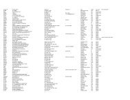
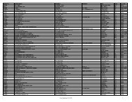
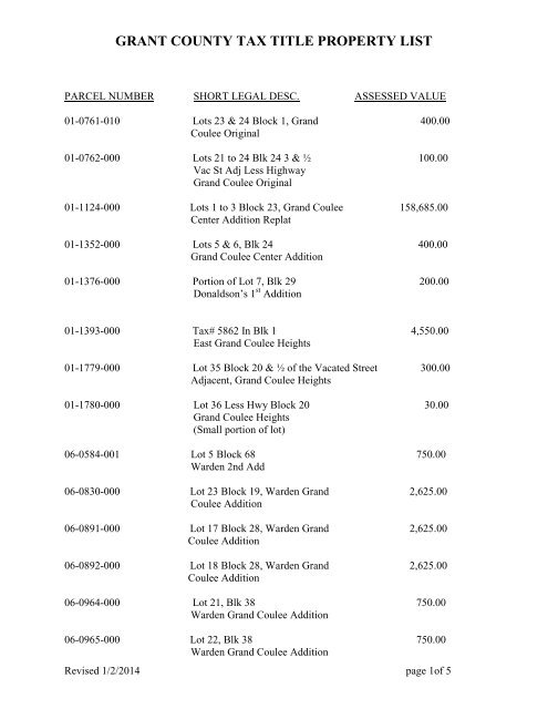
GRANT COUNTY TAX TITLE PROPERTY LIST<br />
PARCEL NUMBER SHORT LEGAL DESC. ASSESSED VALUE<br />
01-0761-010 Lots 23 & 24 Block 1, Grand 400.00<br />
Coulee Original<br />
01-0762-000 Lots 21 to 24 Blk 24 3 & ½ 100.00<br />
Vac St Adj Less Highway<br />
Grand Coulee Original<br />
01-1124-000 Lots 1 to 3 Block 23, Grand Coulee 158,685.00<br />
Center Addition Replat<br />
01-1352-000 Lots 5 & 6, Blk 24 400.00<br />
Grand Coulee Center Addition<br />
01-1376-000 Portion of Lot 7, Blk 29 200.00<br />
Donaldson’s 1 st Addition<br />
01-1393-000 <strong>Tax</strong># 5862 In Blk 1 4,550.00<br />
East Grand Coulee Heights<br />
01-1779-000 Lot 35 Block 20 & ½ of the Vacated Street 300.00<br />
Adjacent, Grand Coulee Heights<br />
01-1780-000 Lot 36 Less Hwy Block 20 30.00<br />
Grand Coulee Heights<br />
(Small portion of lot)<br />
06-0584-001 Lot 5 Block 68 750.00<br />
Warden 2nd Add<br />
06-0830-000 Lot 23 Block 19, Warden Grand 2,625.00<br />
Coulee Addition<br />
06-0891-000 Lot 17 Block 28, Warden Grand 2,625.00<br />
Coulee Addition<br />
06-0892-000 Lot 18 Block 28, Warden Grand 2,625.00<br />
Coulee Addition<br />
06-0964-000 Lot 21, Blk 38 750.00<br />
Warden Grand Coulee Addition<br />
06-0965-000 Lot 22, Blk 38 750.00<br />
Warden Grand Coulee Addition<br />
Revised 1/2/2014 page 1of 5
GRANT COUNTY TAX TITLE PROPERTY LIST<br />
06-0984-000 Lots 15 & 16 Block 42, Warden 1,500.00<br />
Warden Grand Coulee Addition<br />
11/15/13 MB $690.10<br />
06-0992-000 Lots 13 & 14 Block 43 Warden 1,500.00<br />
Grand Coulee Addition<br />
06-1061-000 Lots 6 to 8 Block 57 2,250.00<br />
Warden Grand Coulee Add<br />
06-1067-000 Lots 1 & 2 Block 58, 1,500.00<br />
Warden Grand Coulee Addition<br />
06-1076-000 Lots 23 & 24 Block 58, 1,500.00<br />
Grand Coulee Addition<br />
06-1079-000 Lots 7 & 8 Block 59, 5,250.00<br />
Warden Grand Coulee Addition<br />
11/15/13 MB $1,013.57<br />
06-1108-000 Lots 9 and 10 Block 64 1,500.00<br />
Warden Grand Coulee Add<br />
06-1109-000 Lot 11 Block 64 750.00<br />
Warden Grand Coulee Add<br />
06-1110-000 Lot 13 Block 64 750.00<br />
Warden Grand Coulee Add<br />
06-1132-000 Lots 5 to 8, Block 67 3,000.00<br />
Warden Grand Coulee Add<br />
06-1149-000 Lots 7 & 8 Block 71, 1,500.00<br />
Warden Grand Coulee Addition<br />
11/15/13 MB $700.10<br />
06-1158-000 Lots 13 to 16, Block 72 3,000.00<br />
Warden Grand Coulee Add<br />
07-0851-000 A parcel of land in Section 35, Township 25 90.00<br />
North, Range 28 E.W.M, <strong>Grant</strong> <strong>County</strong>, Washington<br />
described as follows: Beginning at a point 148 feet North and 330 feet West of the Southeast<br />
Corner of the Northeast Quarter of the Southeast Quarter of said Section 35; and extending North<br />
112 feet; thence West 25 feet; thence South 112 feet; thence East 25 feet to the True Point of<br />
Beginning. also known as Lot 13 Block 1, Paul Simpson's unrecorded plat of Coulee City<br />
Addition. 11/15/13 MB $397.98<br />
Revised 1/2/2014 page 2of 5
GRANT COUNTY TAX TITLE PROPERTY LIST<br />
07-0867-000 A parcel of land in Section 35, Township 25 90.00<br />
North, Range 28 E.W.M, <strong>Grant</strong> <strong>County</strong>, Washington described as follows:<br />
Beginning at a point 296 feet South and 405 feet West of the Northeast Corner of the Northeast<br />
Quarter of the Southeast Quarter of said Section 35 and extending West 50 feet; thence South<br />
112 feet; thence East 50 feet; thence North 112 feet to the Point of Beginning. Also known as<br />
Lots 32 and 33, Block 4, Paul Simpson's Plat of Coulee City Addition, unrecorded.<br />
11/15/13 MB $357.98<br />
07-0871-000 A parcel of land in Section 35, Township 25 45.00<br />
north, Range 28 E.W.M., <strong>Grant</strong> <strong>County</strong> Washington<br />
described as follows: Beginning at a point 172 feet<br />
south and 430 feet west of the northeast corner of the<br />
northeast quarter of the southeast quarter of said<br />
section 35 and extending thence west, 25 feet; thence<br />
south, 112 feet; thence east, 25 feet; thence north, 112<br />
feet to the point of beginning. Also known as Lot 16,<br />
Block 4, Paul Simpson’s Plat of Coulee City Addition,<br />
unrecorded<br />
08-0063-000 Lot 1, Blk 6, Soap Lake 625.00<br />
08-0694-012 Lot 12, 13, 14, 15, 16, 17 & 18 of Block 5 & 126,130.00<br />
North 10’ of Vacated 4 th Ave Adjacent,<br />
George Pruitt’s Addition<br />
11/15/13 MB $32,674.42<br />
08-1487-000 Lots 1 to 5 Block 17, Salome 3,750.00<br />
08-1488-000 Lots 6 to 8 Block 17, Salome 2,250.00<br />
08-1549-000 Lot 1 Block 32, Salome 750.00<br />
08-1550-000 Lot 2 Block 32, Salome 750.00<br />
08-1551-000 Lot 3 Block 32, Salome 750.00<br />
08-1552-000 Lot 5 Block 32, Salome 750.00<br />
08-1553-000 Lot 5 Block 32, Salome 750.00<br />
08-1554-000 Lot 6 Block 32, Salome 750.00<br />
08-1555-000 Lot 7 Block 32, Salome 750.00<br />
08-1556-000 Lot 8 Block 32, Salome 750.00<br />
08-1557-000 Lot 9 Block 32, Salome 750.00<br />
Revised 1/2/2014 page 3of 5
GRANT COUNTY TAX TITLE PROPERTY LIST<br />
08-1558-000 Lot 10 Block 32, Salome 750.00<br />
08-1559-000 Lot 11 Block 32, Salome 750.00<br />
10-2330-000 Dedicated path way, power pointe 1 Major Plat 2,200.00<br />
11-0178-000 <strong>Tax</strong> # 1190 In NE Qtr. of NW Qtr, 3,000.00<br />
Sec.26 Tn. 19 Range 28.<br />
11-0705-000 Tract 52 South of Short Plat 0.00<br />
#26-2 Park Orchard Tracts<br />
12-1138-233 Lot 34, Willow Crest Estates Phase 3 105,415.00<br />
14-1280-024 Private Roads In Beverly Orchards 20.00<br />
11/15/13 MB $357.68<br />
14-1365-000 Lot 2 Block 7 Less FU 60.00<br />
Ephrata Orchards 1 st Add<br />
14-1501-000 Lot 6, Block 28 2,500.00<br />
<strong>Grant</strong> Orchards<br />
15-1765-000 N20’ of S ½ SENE Sec 20 19 25 1,135.00<br />
15-2028-000 Southeast quarter of the northeast quarter north 1,615.00<br />
of farm units in section 35, township 21, north,<br />
range 25 E.W.M., <strong>Grant</strong> <strong>County</strong> Washington<br />
16-1403-000 Tract A in Section 12 19 27 1,400.00<br />
.50 acres<br />
16-1641-011 SESW Section 13 20 27 20,735.00<br />
41.47 acres<br />
16-1781-000 NWNW Section 14 21 27 14,000.00<br />
40 acres<br />
16-2112-014 E1/2SENESW Section 2 24 27 1,250.00<br />
5 acres<br />
16-2114-005 W1/2SWNWSE Section 2 24 27 1,250.00<br />
5 acres<br />
17-0502-000 <strong>County</strong> Road in Sec. 11 Tn. 19N 5.00<br />
Range 28.<br />
Revised 1/2/2014 page 4of 5
GRANT COUNTY TAX TITLE PROPERTY LIST<br />
17-1293-000 SW Qtr. of SW Qtr. South of Canal N. 10.00<br />
line and North of Canal S. line., Sec 29,<br />
Tn. 22N, Range 28<br />
18-2285-003 <strong>Tax</strong> # 8907 in NE Qtr. of NE Qtr. Sec. 15 1,500.00<br />
Tn. 28 Range 30<br />
18-2352-000 <strong>Tax</strong> # 275 & 276 Sec 35 28 30 1,110.00<br />
4.43 acres<br />
Revised 1/2/2014 page 5of 5