Conditional Use Permit Application Form - Grant County Government
Conditional Use Permit Application Form - Grant County Government
Conditional Use Permit Application Form - Grant County Government

Create successful ePaper yourself
Turn your PDF publications into a flip-book with our unique Google optimized e-Paper software.
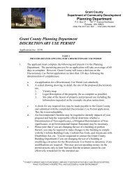
<strong>Grant</strong> <strong>County</strong>Department of Community DevelopmentPlanning DepartmentP.O. Box 37 - 457 1 st Avenue NorthwestEphrata, WA 98823(509) 754-2011 Ext. 620 - FAX (509) 754-6097<strong>Grant</strong> <strong>County</strong> Planning DepartmentCONDITIONAL USE PERMITFees $1,000 SEPA Environmental Checklist (if applicable) $300PART IPROCEDURES FOR APPLYING FOR A CONDITIONAL USE PERMIT1. The applicant must complete the following and present it to the Planning Department.The permitting process for an application will take an average of 60 days to complete.However, <strong>Grant</strong> <strong>County</strong> will issue a decision on the <strong>Conditional</strong> <strong>Use</strong> <strong>Permit</strong> applicationno later than 120 days following the determination of completeness.a. An application for a <strong>Conditional</strong> <strong>Use</strong> <strong>Permit</strong> (see attached);b. A scaled drawing showing, in detail, the site of the proposed use in which aconditional use is needed.1) Vicinity map2) Legal Description of property (be as complete as possible)3) Map or plot plan of the layout of property and proposed use including thefollowing:a) Scale of drawing.b) North arrow.c) Location of the proposed project including existing and proposedstructure dimensions and distances to property lines.d) Location of all proposed and existing utilities including power, water,septic tank and drainfield.e) Off street parking (if applicable).f) Location of all proposed and existing roads providing access toproperty, driveways, parking areas, rights-of-way and easements.g) Location of any distinguishing physical features located on the propertyincluding but not limited to streams, culverts, drainage ways, wetlands,bluffs, etc.c. A check may be made payable to “<strong>Grant</strong> <strong>County</strong>” and submitted with thecompleted <strong>Conditional</strong> <strong>Use</strong> <strong>Permit</strong> application. This fee is non-refundable.An Environmental Checklist may be required to identify impacts from yourproposal and help the responsible official determine whether a Determination ofNon-significance, a Mitigated Determination of Non-significance, or an“TO MEET CURRENT AND FUTURE NEEDS, SERVING TOGETHER WITH PUBLIC AND PRIVATE ENTITIES,WHILE FOSTERING A RESPECTFUL AND SUCCESSFUL WORK ENVIRONMENT.”
Environmental Impact Statement may be necessary. This $300.00 fee is also nonrefundable.d. Please note that if you are changing the use of a building or portion thereof, youmay be required to make changes to the building to comply with the UniformBuilding Code, Uniform Fire Code, and Americans with Disabilities Act, etc. Youare requested to contact the <strong>Grant</strong> <strong>County</strong> Building Department if you arechanging the use of a building or modifying a structure for the <strong>Conditional</strong> <strong>Use</strong><strong>Permit</strong> to determine if any modifications are required. This may prevent spendingmoney on the permit process only to later find out that the structure cannot be costeffectively remodeled for the intended use.2. The Planning Department Staff will do the following:a. Prepare a list of names and addresses of all property owners within three hundred(300) feet of the exterior boundaries of the subject property;b. Provide notice of application upon the issuance of a determination ofcompleteness;c. Mail notice of any open record hearing (if applicable) to the applicant and theapplicant’s representative, the above list of names, and any person who submitswritten or oral comments on the application at least fifteen (15) calendar days priorto the hearing; and shalld. Publish legal notice of public hearing of a <strong>Conditional</strong> <strong>Use</strong> <strong>Permit</strong> according to therequirements of the Local Project <strong>Permit</strong> Review Ordinance 97-192-CC.3. The Hearing Examiner meets on the second (2 nd ) Wednesday of the month. Theapplication will be heard before the Hearing Examiner at an open record public hearing.At the public hearing, the applicant or representative shall be present to answer anyquestions the Hearing Examiner may have relative to the proposed use. You will benotified by mail as to what date your application will be heard before the HearingExaminer.4. Hearing: After the open record public hearing and based upon findings of fact, theHearing Examiner will determine whether the conditional use permit is to be granted,granted with conditions, or denied. The Hearing Examiner's written decision should beissued within 10 working days of the date of the hearing.5. Time Frame for Decision: Once the application is deemed complete, the reviewprocess will begin. Provided that there is not a continuance on the application, generallya decision on the conditional use permit will be made within 120 days, subject to anopen record public hearing.6. Appeals: Decisions of the Hearing Examiner shall be final unless the original applicantor a party with standing makes an appeal to the Superior Court of <strong>Grant</strong> <strong>County</strong>pursuant to RCW 36.70C and the <strong>Grant</strong> <strong>County</strong> Local Project <strong>Permit</strong> Review Ordinance,97-192-CC.<strong>Conditional</strong> <strong>Use</strong> <strong>Permit</strong> Adopted 3/99, Fee chg 5/09<strong>Application</strong> - 2 - Resolution #09-037-CC
<strong>Conditional</strong> <strong>Use</strong> <strong>Permit</strong> – Responses to Criteria of ApprovalPursuant to GCC 25.08.050, any request for a conditional use permit shall be accompanied bya narrative statements demonstrating how the proposed request conforms to the criteria forapproval specified in GCC 25.08.060. Please provide a narrative statement addressing eachof the following criteria for approval and how your proposal complies with the criteria:1. The proposed use will not be contrary to the intent or purposes and regulations of the<strong>Grant</strong> <strong>County</strong> Code or the Comprehensive Plan.2. The proposal is appropriate in design, character and appearance with the goals andpolicies for the land use designation in which the proposed use is located.3. The proposed use will not cause significant adverse impact on the human or naturalenvironment that cannot be mitigated by conditions of approval.4. The cumulative impact of additional requests for like actions (the total of theconditional uses over time or space) will not produce significant adverse effects to theenvironment that cannot be mitigated by conditions of approval.5. The proposal will be served by adequate facilities including access, fire protection,water, stormwater control, and sewage disposal facilities.6. The location, size, and height of buildings, structures, walls and fences, and screeningvegetation for the proposed use shall not unreasonably interfere with allowabledevelopment or use of neighboring properties.7. The pedestrian and vehicular traffic associated with the conditional use will not behazardous to existing and anticipated traffic in the neighborhood.8. Land uses, activities, and structures that are allowable as conditional uses must alsocomply with any required performance standards specified in GCC 23.08.9. The proposal does not include any use or activities that would result in the siting of anincompatible use adjacent to an airport or airfield (RCW 36.70).10. The proposal conforms to the standards specified in GC 23.12.<strong>Conditional</strong> <strong>Use</strong> <strong>Permit</strong> Adopted 3/99, Fee chg 5/09<strong>Application</strong> - 3 - Resolution #09-037-CC
All requested information shall be provided - use black ink or type for photocopying purposesPART IICONDITIONAL USE PERMIT APPLICATIONLegal Owner’s Name: _______________________________________________________________Mailing Address: __________________________________________________________________City: _______________________ State: ________________ Zip: ________________________Phone: ______________________ (Work): ______________ Fax: ________________________If applicant is not the owner, include the written owner authorization form below designating thecontact to serve as representative.Owner’s Designated Contact: _________________________________________________________Mailing Address: ___________________________________________________________________City: _______________________ State: ________________ Zip: ________________________Phone: _____________________ (Work): _______________ Fax: ________________________Project/Proposal Site Area (Acres or sq. ft.): ______________________________________________Assessor Tax Parcel No.(s) of Proposal Site: _____________________________________________Adjacent Area Owned or Controlled (Acres or sq. ft.): ______________________________________Assessor Tax Parcel No.(s) of Adjacent Land Owned or Controlled: ___________________________Street Address of Proposed Site (if any): __________________________________________________________________________________________________________________________________Describe Existing <strong>Use</strong>(s) on Proposed Site (Such as buildings, well, sewer drainfield and others):_____________________________________________________________________________________________________________________________________________________________________________________________________________________________________________________Existing Zoning Classification: _______________________________________________________Comprehensive Plan Category: _______________________________________________________Growth Management Act Designation: Within IUGA or UGA? ( ) yes ( ) noSchool District: ____________________________________________________________________Fire District: ______________________________________________________________________Water Purveyor: ____________________________________________________________________Irrigation District: __________________________________________________________________Proposed <strong>Use</strong> of Property:( ) Duplexes ( ) Business ( ) Multi-Family dwelling( ) Industrial ( ) Mixed <strong>Use</strong> ( ) Single-family dwelling( ) Manufactured Homes ( ) Other: Please describe______________________________________________________________________________________________________________________________________________________________________________________________________________________________________________________<strong>Conditional</strong> <strong>Use</strong> <strong>Permit</strong> Adopted 3/99, Fee chg 5/09<strong>Application</strong> - 4 - Resolution #09-037-CC
List Previous <strong>Grant</strong> <strong>County</strong> Actions Involving this Property: (Such as tax segregation application,certificate of exemptions, GA or EA affidavit, subdivision, lot segregation or Agriculture Districtsegregation, zone change, variance, temporary use SEPA review, estate transfer, zoning code violationor others) ___________________________________________________________________________________________________________________________________________________________________________________________________________________________________________________________________________________________________________________________________________________________________________________________________________________________________________________________________________________________________LEGAL INFORMATIONLocation of Proposal Site (General description by which direction and how far from roads andintersections and other community features): _______________________________________________________________________________________________________________________________________________________________________________________________________________________________________________________________________________________________________________________________________________________________________________________________________________________________________________________________________Section(s): _____ Township: ______ Range: _______ Legal description attached: ( ) yes( ) noName of Public Road (s) providing access: _________________________________________________________________________________________________________________________________Width of Property Fronting on Public Road: ______________________________________________Section of the zoning ordinance under which it is claimed that a conditional use should be granted:__________________________________________________________________________________Purpose for the requested conditional use: ___________________________________________________________________________________________________________________________________________________________________________________________________________________Is the proposed use to be temporary or permanent? If temporary, please explain: ____________________________________________________________________________________________________________________________________________________________________________________If you have any additional comments, please attach them on a separate sheet of paper.<strong>Conditional</strong> <strong>Use</strong> <strong>Permit</strong> Adopted 3/99, Fee chg 5/09<strong>Application</strong> - 5 - Resolution #09-037-CC
PART IIILEGAL OWNER SIGNATURE(Signature of legal owner or representative as authorized by legal owner)I, the undersigned, swear or affirm under penalty of perjury that the above responses are madetruthfully and to the best of my knowledge.I further swear or affirm that I am the owner of record of the area proposed for the previouslyidentified land use action, or, if not the owner, attached herewith is written permission from the ownerauthorizing my actions on his or her behalf.Name: __________________________Address: ________________________________________________________Date: ______________________________Phone: _____________________________Zip: ______________________________________________________________________Signature of Applicant or representative____________________________________DateSTATE OF WASHINGTON ) ss:COUNTY OF GRANT )Notary(For Part III Above)SUBSCRIBED AND SWORN to me this ______ day of _______________, 20____.NOTARY SEAL_________________________________Notary SignatureNotary Public in and for the State of WashingtonResiding at: ____________________________My appointment expires: __________________PART IV(To be completed by the Planning Department)Date Submitted: _________________________ Planner: _______________________________Total Fees: _____________________________ Receipt #: ______________________________File #: _________________________________ Complete <strong>Application</strong>: ___________________<strong>Conditional</strong> <strong>Use</strong> <strong>Permit</strong> Adopted 3/99, Fee chg 5/09<strong>Application</strong> - 6 - Resolution #09-037-CC
Critical Areas ChecklistPursuant to <strong>Grant</strong> <strong>County</strong> 24.08.0701) Section ______ Township ______ Range ______ Parcel Number ___________________2) Site Address:______________________________________________________________________3) Directions to site and landmarks to help staff locate the site:___________________________________________________________________________________________________________________________________________________________________________________________________4) If this checklist is submitted independently, please attach a Section map obtained from the Assessor’soffice and highlight the project area. Attached? Yes ___ No ___5) Proposed uses: ____________________________________________________________________6) For independent CAO review, please attach a Site Plan. Attached? Yes ___ No ___7) Please answer the following questions concerning Critical Area indicators located on or within 300feet of the project area.a) Are you aware of any environmental documentation that has been prepared related to criticalareas that includes the subject area? (if yes, please attach a list of document titles).Yes ___ No ___ Unknown ___b) Are there any surface waters (including year-round and seasonal streams, saltwater, lakes, ponds,bogs, fens, swamps, marshes)?Yes ___ No ___ Unknown ___c) Is there vegetation that is associated with wetlands?Yes ___ No ___ Unknown ___d) Have any wetlands been identified?Yes ___ No ___ Unknown ___e) Are there areas where the ground is consistently inundated or saturated with water?Yes ___ No ___ Unknown ___f) Is there any State or Federally listed sensitive, endangered or threatened species and habitats?Yes ___ No ___ Unknown ___g) Are there slopes of 15% or greater?Yes ___ No ___ Unknown___h) Is the project located within a Flood Hazard Zone?Yes ___ No ___ Unknown ___i) Do you know of any geologic hazards (for example: erosion hazards, landslide hazards, seismichazards and mine hazards)?Yes ___ No ___ Unknown___j) Do you know of any cultural resource sites (lands, sites, structures with historic or archaeologicalsignificance) located on the proposed site?Yes ___ No ___ Unknown___Information regarding endangered species, wetland vegetation and flood hazard zones is available forpublic use at the <strong>Grant</strong> <strong>County</strong> Planning Department. I understand that if the information on this form islater determined to be incorrect, the project or activity may be subject to conditions or denial as necessaryto meet the requirements of GCC 24.08, the <strong>Grant</strong> <strong>County</strong> Critical Areas Ordinance.__________________________________Applicant’s Signature_____________________Date
PRE-APPLICATION REVIEW CONFERENCE WAIVERPre-application conferences are intended as an informal discussion and review of possibleapplications to assist the applicant in discovery of appropriate county regulations,standards, application materials and review processes, that would be required of a project,as well as to identify environmental issues that may arise in connection with theapplication for proposed development.• However, the requirement for the pre-application conference may be waived bythe administrative official with the concurrence of the applicant.<strong>Application</strong> No.:Type of <strong>Application</strong>:I hereby request a waiver to the pre-application conference as providedin the <strong>Grant</strong> <strong>County</strong> Local Project Review Ordinance (Ord. #97-192-CC).I have been provided with copies of the county ordinances and other relatedinformation concerning this application. Furthermore, I have read andunderstand the requirements and will be providing all the necessaryinformation needed for the formal review process of this application.NameDateADMINISTRATIVE REVIEWUpon consideration of the application and supplemental materials and informationsubmitted thus far by the applicant, Administrator finds that:1) the application itself is / is not relatively simple; and2) the administrative official had made a good faith determination that theapplicant will / will not be harmed by the failure to hold a pre-applicationconference.The above request for a waiver of the Pre-<strong>Application</strong> Conference requirement is herebyAPPROVED / DENIED.Project PlannerDate
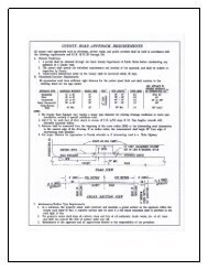
SITE PLAN INSTRUCTIONSINSTRUCTIONS:A. Complete the information requested in the gray box at the top of the reverse side of this page and draw your site planin the space provided; you may use additional 8½ X 11 sheets as needed;B. Identify the north arrow in the space provided;C. <strong>Use</strong> an accurate scale for drawing (ie; “1 inch = 10 feet” or “1 inch = 20 feet” or “1 inch = 100 feet” etc.);D. Draw the boundaries of the parcel including the dimensions (you may need a plat map copy from the assessor’s office)E. Draw the location and dimensions of all existing buildings and structures;F. Draw the location of the proposed project including the structure dimensions, and distances to property lines andexisting buildings and structures;G. Draw the location of all proposed and existing utilities (including power, phone, water, sewer systems, reservedrainfield, etc.);H. Draw the location and dimensions of all existing and proposed roads, driveways, parking areas, rights-of-way andeasements;I. Draw the location of any distinguishing physical features located on or adjacent to the property (including but notlimited to : streams, culverts, drainage ways, wetlands, slopes, bluffs, etc.);J. In the gray box at the bottom of the page, please provide detailed directions to the site;K. If you have questions regarding these instructions, please see the “EXAMPLE” SITE PLAN provided below. If youhave further questions not covered in the example, please call (509) 754-2011, extension 620 for assistance.“EXAMPLE” SITE PLANIN ORDER TO PROCESS LANDUSE APPLICATIONS, ALL SUBMISSIONS MUST INCLUDE A COMPLETEDSITE PLAN MAP OF THE PROPOSED PROJECT (SEE INTRUCTIONS), submission of an incomplete site plan mapwill be considered as an incomplete application and returned to the applicant:PROJECT/ OWNER NAME ___________________________________________ DATE _____________________PARCEL #(s) ___________________________________ DRAWING SCALE ________ inch(s) = ________ feetNOTE: Please label all parcel boundaries with “Property Line”NORTHARROWDirections to the Site:___________________________________________________________________________________________________________________________________________________________________________________________________________________________________________________________________________________________________
SITE PLANIN ORDER TO PROCESS LAND USE APPLICATIONS, ALL SUBMISSIONS MUST INCLUDE A COMPLETEDSITE PLAN MAP OF THE PROPOSED PROJECT (SEE INTRUCTIONS), submission of an incomplete site plan mapwill be considered as an incomplete application and returned to the applicant:PROJECT/ OWNER NAME ___________________________________________ DATE _____________________PARCEL #(s) ___________________________________DRAWING SCALE ________ inch(s) = ________ feetNOTE: Please label all parcel boundaries with “Property Line”NORTHARROWDirections to the Site: __________________________________________________________________________________________________________________________________________________________________________________________________________________________________________________________________________________________________________________________________________________________________________________________
GRANT COUNTY HEALTH DISTRICTPO BOX 37, EPHRATA, WA 98823(509) 754-6060In response to a request from the <strong>Grant</strong> <strong>County</strong> Planning Department for comment on availability of potable waterand appropriateness of sewer disposal in connection with a proposed land use application (Project) beingprocessed by that department per RCW 58.17.150.____Subdivision ____<strong>Conditional</strong> <strong>Use</strong> <strong>Permit</strong> ____Discretionary <strong>Use</strong> ____OtherName of Applicant ___________________________________________________________________________Mailing address, City, State, Zip _________________________________________________________________System address, City, State, Zip _________________________________________________________________Proposed Subdivision Name _____________________________________Div.____Blk.____Lots____________Tax parcel (s) _________________________________________________Sec.____Twp.____Range__________Applicant Signature: _________________________________________________Date: _____________________________________________________________________________________________________________This section for Health District use only:WATER AVAILABILITYThe <strong>Grant</strong> <strong>County</strong> Health District does not review this proposed plat or other land use permits for the legalavailability of water nor for compliance with RCW Chapter 19.27 (building permits).☐Evidence of availability of a source of potable water for this Project appears to be established by theproposed source from:☐☐ Existing public system ☐ Group A or Group B water system ☐ Well(s)Evidence of availability of a source of potable water for this Project appears not to be provided.SEWER AVAILABILITY☐ Evidence of general suitability for on-site sewer system installation or availability of a connection to asewer system for this Project appears to be appropriate per:☐☐ District on-site tests per WAC Chapter 246-272A☐ Washington State Dept of Ecology approved system☐ Washington State Dept of Health approvedsystemEvidence of availability of adequate sewer disposal for this Project appears not to be provided.District on-site tests provide a general determination of soil types and probable on-site sewer systems available foruse. Specific configuration of lots and locations of other features such as wells and buildings will determine theactual availability of on-site septic systems for each lot of this Project.Other than District on-site tests, the information provided herein is based on information available to the Districtfrom others and the District cannot and does not certify the accuracy of that information.Health District Representative Signature: __________________________________ Date: _________________
<strong>Grant</strong> <strong>County</strong>Department of Community DevelopmentPlanning DepartmentP.O. Box 37 - 457 1 st Avenue NorthwestEphrata, WA 98823(509) 754-2011 Ext. 620 - FAX (509) 754-6097LAND USE ACTIVITYACKNOWLEDGEMENT AND AUTHORIZATION FORMI, ___________________________________________________________, legal ownerof Parcel (s) _______-_______-________, _______-_______-_______, hereby authorize____________________________________________________to act as my agent, in the_____________________________________________________application filed in the<strong>Grant</strong> <strong>County</strong> Planning Department._________________________________Legal Owner Signature_________________________________Date__________________________________Legal Owner Signature__________________________________Date