UNCORRECTED PAGE PROOFS - USGS Alaska Science Center
UNCORRECTED PAGE PROOFS - USGS Alaska Science Center
UNCORRECTED PAGE PROOFS - USGS Alaska Science Center

Create successful ePaper yourself
Turn your PDF publications into a flip-book with our unique Google optimized e-Paper software.
spe371-01 page 25 of 31<br />
Geologic signature of early Tertiary ridge subduction in <strong>Alaska</strong> 25<br />
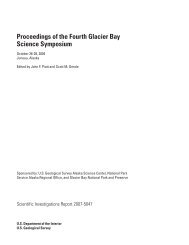
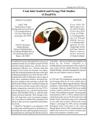
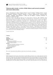
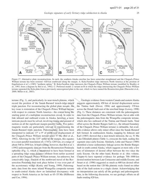
Figure 17. Alternative plate reconstructions. In each, the southern <strong>Alaska</strong> orocline has been somewhat straightened and the Chugach–Prince<br />
William terrane has been restored ~820 km southward along the margin. A: Kula-Farallon ridge intersects North America at the position of<br />
Engebretson et al.ʼs (1985) “northern option.” B: Kula-Farallon ridge intersects the Chugach–Prince William terrane (modiÞed by Bradley et<br />
al., 1993, from a diagram by Bol et al., 1992). C: Preferred model: a variant on B in which the ridge intersecting the Chugach–Prince William<br />
terrane separated the Kula plate from a previously unrecognized plate to the east, which we have named the Resurrection plate (Haeussler et al.,<br />
2000; Miller et al., 2003).<br />
terrane (Fig. 1), and particularly its near-trench plutons, which<br />
record the position of the Sanak-Baranof trench-ridge-trench<br />
triple junction. For reconstructing the global plate mosaic, the<br />
key issue is restoration of the Chugach–Prince William terrane<br />
with respect to cratonic North America—the craton being the<br />
starting point of a multiplate reconstruction circuit. In order to<br />
link inboard and outboard events in <strong>Alaska</strong>, however, a more<br />
intricate puzzle must be solved, involving timing and amount of<br />
motion on all the signiÞcant margin-parallel faults. Two paleomagnetic<br />
results are particularly relevant to repositioning the<br />
Sanak-Baranof triple junction. Paleomagnetic data have been<br />
interpreted to indicate 13° ± 9° of northward displacement of<br />
the Chugach–Prince William terrane since 57 Ma (Bol et al.,<br />
1992). Allowing for the 325° strike of the margin, this equates<br />
to a coast-parallel translation of ~1745 ± 1205 km, or a range of<br />
about 540 to 2950 km. It bears noting, however, that Bol et al.ʼs<br />
(1992) paleomagnetic data are from the Resurrection Peninsula<br />
ophiolite (Fig. 1), which is interpreted to have been formed at<br />
a spreading ridge some distance offshore from earlier accreted<br />
parts of the Chugach–Prince William terrane. An unknown, but<br />
conceivably large, fraction of the northward travel of the Resurrection<br />
Peninsula thus took place before it was even part of<br />
the accretionary wedge (Kusky and Young, 1999). Paleomagnetic<br />
data from the more inland Wrangellia composite terrane<br />
in south-central <strong>Alaska</strong> show no latitudinal discrepancy with<br />
respect to North America as far back as 65–55 Ma (Hillhouse<br />
and Coe, 1994).<br />
Geologic evidence from western Canada and eastern <strong>Alaska</strong><br />
suggests approximately 450 km of dextral displacement across<br />
the Tintina fault (Dover, 1994) and approximately 370 km<br />
across the Denali fault east of the oroclinal hinge (Lowey, 1998)<br />
(Fig. 1). These distances are consistent with the paleomagnetic<br />
data from the Chugach–Prince William terrane, but at odds with<br />
the paleomagnetic data from the Wrangellia composite terrane,<br />
which also lies outboard of the Tintina and Denali faults. Total<br />
offset across the Border Ranges fault (i.e., the inboard boundary<br />
of the Chugach–Prince William terrane) is debatable, but available<br />
evidence allows only minor offset since the Sanak-Baranof<br />
belt formed. In southeastern <strong>Alaska</strong>, mapping by Johnson and<br />
Karl (1985) showed that a near-trench intrusion, the ca. 51 Ma<br />
Lake Elfendahl pluton (Table 1), crosscuts the fault, sealing this<br />
segment since early Eocene. Similarly, Little and Naeser (1989)<br />
identiÞed a loose sedimentary linkage across the Border Ranges<br />
fault in south-central <strong>Alaska</strong>, which suggests at most only a few<br />
tens of kilometers of dextral offset between the two since the<br />
early Eocene. On the other hand, Roeske et al. (this volume,<br />
Chapter 6) have reported evidence for perhaps 700–1000 km<br />
dextral motion between Late Cretaceous and middle Eocene, and<br />
Smart et al. (1996) suggested as much as 600 km dextral offset<br />
based on the notion that 120 Ma plutonic rocks found on either<br />
side of the fault restore to a single cluster. Acknowledging that<br />
no interpretation can satisfy all the geologic and paleomagnetic<br />
data, in the following discussion, we use geologic offsets on all<br />
faults totaling 820 km.<br />
<strong>UNCORRECTED</strong> <strong>PAGE</strong> <strong>PROOFS</strong>