spe371-01 page 4 of 31 4 D. Bradley et al. overrode a hotspot; very young, hot, oceanic lithosphere was subducted; a “leaky transform” entered the trench (Tysdal et al., 1977); near-trench magmatism was the product of ßexural extension of a single downgoing plate (Tysdal et al., 1977); and a subducted slab broke off, exposing the overriding plate to a slab window. As will be discussed at greater length below, the evidence now in hand is best explained by the ridge subduction hypothesis. Accordingly, as this volume itself makes clear, the emphasis of current research has shifted from testing alternative tectonic scenarios, to reÞning the ridge subduction scenario and studying processes of ridge subduction. By analogy, studies of the Franciscan Complex have long since advanced beyond the question of whether or not it is the product of subduction, to questions about subduction zones. Still, it behooves us to not forget alternative explanations that are no longer in the forefront. This philosophy guides the Þrst part of the present paper, a non-interpretive discussion of <strong>Alaska</strong>ʼs early Tertiary geologic record. Our descriptive overview of the geology is based on our own experience gained through Þeld work during the past two decades, as well as on published Þndings. Most of our work was done in connection with 1:250,000-scale reconnaissance bedrock mapping and resource assessment by the U.S. Geological Survey in the Seldovia, Seward, Cordova, Valdez, Sitka, Port Alexander, Talkeetna, and Talkeetna Mountains quadrangles (Figs. 2 and 3). We emphasize geology of the accretionary prism, rocks most pertinent to the subduction history. SpeciÞc aspects of the early Tertiary geology of the accretionary prism have been discussed in several dozen publications—but a comprehensive synthesis has been lacking. The early Tertiary record of interior <strong>Alaska</strong> is covered here in less detail, because new research has just been started that will quickly eclipse our present knowledge. In the <strong>Alaska</strong>n interior, various episodes of early Tertiary basin subsidence, uplift, magmatism, and mineralization attest to signiÞcant tectonic activity that presumably was related to events along the continental margin—but reliable correlations must await tighter dating and new information on the amount of margin-parallel strike slip. The second part of the paper is interpretive. Here we present the case that ridge subduction provides a unifying rationale for the broad range of evidence, and we consider the various competing, but to us less satisfactory, hypotheses. We conclude with some general observations about ridge subduction, and a discussion of some outstanding problems in <strong>Alaska</strong>. GEOLOGIC SETTING <strong>Alaska</strong> consists of a collage of terranes that were accreted to the western margin of North America as a result of complex plate interactions through most of the Phanerozoic. Comprehensive reviews and bibliographies of the regional geology are given by Plafker et al. (1994) and Nokleberg et al. (1994). Those terranes of particular signiÞcance to the present study are introduced here along a south-to-north transect along the hinge of the southern <strong>Alaska</strong> orocline (Fig. 1). <strong>Alaska</strong>ʼs PaciÞc margin is underlain by a Mesozoic and Cenozoic accretionary prism, referred to as the Chugach–Prince William terrane (or composite terrane), which is discussed in more detail below. It was built in piecemeal fashion by subduction-accretion and lies seaward of the Wrangellia composite terrane (Fig. 3). Between the two, and resting on both, lies the Cook Inlet forearc basin. The modern forearc basin had an ancestry in the Triassic, Jurassic, and parts of the Cretaceous when it received many kilometers of sediment from the nearby magmatic arc. The early Tertiary history of this basin bears on the ridge subduction hypothesis (Trop et al., this volume, Chapter 4). The active volcanoes of the modern arc are built largely on basement of the Wrangellia composite terrane, which includes arc batholiths and associated volcanic and volcaniclastic rocks of Jurassic, Cretaceous, and early Tertiary age. The inboard suture of the Wrangellia composite terrane is marked by a belt of deformed Jurassic-Cretaceous ßysch, host to a suite of 59–55 Ma granitic plutons that will be mentioned in a later section on possible inboard effects of the slab window. The complex region between the <strong>Alaska</strong> Range and Brooks Range (Fig. 1), underlain largely by the Yukon-Tanana continental margin terrane, is of only peripheral interest to the present study. In northern <strong>Alaska</strong>, the Brooks Range orogen records a Jurassic to Early Cretaceous collision between the Yukon-Koyukuk magmatic arc and a southfacing (present coordinates) passive margin of the Arctic <strong>Alaska</strong> terrane. Tectonic transport was to the north and the resulting orogenic load formed a foreland basin on <strong>Alaska</strong>ʼs North Slope (Fig. 1). The <strong>Alaska</strong>n terrane collage is cut by margin-parallel strike-slip faults such as the Border Ranges, Denali, and Tintina (Fig. 1). As will be discussed, the sense, amount, and timing of motion bears on correlations between events in the <strong>Alaska</strong>n interior and those in the Chugach–Prince William terrane. The Chugach–Prince William accretionary prism is subdivided into belts of accreted ocean-ßoor rocks that young in a seaward direction. The most landward belt consists of highpressure metamorphic rocks (Fig. 3) that were metamorphosed during the Early Jurassic, as summarized, for example, by Dusel-Bacon et al. (1993). The next belt is an argillite-matrix melange containing blocks and fault slices of Triassic to middle Cretaceous chert and basalt, undated graywacke, rare Permian limestone, and a few Triassic-Jurassic ultramaÞc-maÞc complexes (Uyak Complex, McHugh Complex, and Kelp Bay Group; Connelly, 1978; Bradley and Kusky, 1992; Decker, 1980). Small near-trench plutons and numerous dikes intrude these rocks. The next outboard belt contains Upper Cretaceous ßysch that has been assigned to the Shumagin Formation, Kodiak Formation, Valdez Group, and part of the Sitka Graywacke (Moore, 1973; Nilsen and Moore, 1979; Nilsen and Zuffa, 1982; Decker, 1980). The biggest near-trench plutons and largest areas of high-temperature, low-pressure metamorphism occur in the Upper Cretaceous ßysch belt. In Prince William Sound, maÞc volcanic rocks are interbedded with ßysch assigned to the Valdez Group. Farther outboard lie belts of ßysch assigned to the Ghost Rocks Formation and Orca Group (Moore et al., 1983; Moore and Allwardt, 1980; Helwig and <strong>UNCORRECTED</strong> <strong>PAGE</strong> <strong>PROOFS</strong>
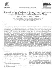
spe371-01 page 5 of 31 Geologic signature of early Tertiary ridge subduction in <strong>Alaska</strong> 5 <strong>UNCORRECTED</strong> <strong>PAGE</strong> <strong>PROOFS</strong> Figure 3. Geologic map of south-central <strong>Alaska</strong> showing belts of accreted rocks, near-trench igneous rocks, and localities mentioned in text. Abbreviations for quadrangles: AN—Anchorage; BG—Bering Glacier; BS—Blying Sound; CV—Cordova; IB—Icy Bay; KN—Kenai; MC—McCarthy; MI—Middleton Island; SR—Seward; SV—Seldovia; TK—Talkeetna Mountains; TL—Talkeetna; TY—Tyonek; VA—Valdez. (Talkeetna and Talkeetna Mountains quadrangles are outside the map area.)