Download - Introducing IMOS
Download - Introducing IMOS
Download - Introducing IMOS

Create successful ePaper yourself
Turn your PDF publications into a flip-book with our unique Google optimized e-Paper software.
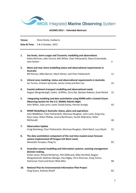
ACOMO 2012 – Extended Abstracts<br />
Venue:<br />
Shine Dome, Canberra<br />
Date & Time: 3 & 4 October, 2012<br />
1. Sea levels, storm surges and Tsunamis; modelling and observations<br />
Kathy McInnes, John Church, Neil White, Chari Pattiaratchi, Diana Greenslade,<br />
Jane Sexton 3<br />
2. Wave and near shore modelling status and observational requirements in<br />
Australia<br />
Bill Peirson, Mike Banner, Mark Hemer, and Chari Pattiaratchi 11<br />
3. Littoral zone modeling: status and observational requirements in Australia<br />
Ian Turner, Graham Symonds, James Carley and Ron Cox 22<br />
4. Coastal sediment‐transport modelling and observational needs<br />
Nugzar Margvaleshgili, Cedric. Griffiths, Chris Dyt, Barbara Robson, Scott Nichol 31<br />
5. Integrating modeling and data assimilation using ROMS with a Coastal Ocean<br />
Observing System for the U.S. Middle Atlantic Bight<br />
John Wilkin, Julia Levin, Javier Zavala‐Garay, Hernan Arango 43<br />
6. ROMS Modelling in Australia: Status, plans and aspirations<br />
John Middleton, Chari Pattiaratchi, Moninya Roughan, John Luick, Greg Ivey,<br />
Ryan Lowe, Helen Phillips, Jessica Benthusen, Sarath Wijeratne, Helen<br />
McDonald 46<br />
7. Observation Update<br />
Craig Steinberg, Chari Pattiaratchi, Moninya Roughan, Mark Baird, Lucy Wyatt 52<br />
8. The data assimilation component of the real‐time coastal ocean forecast<br />
system implemented off Oregon (US West coast)<br />
Alexander Kurapov, Peng Yu 65<br />
9. Australian coastal modelling and information systems: assisting management<br />
decision making.<br />
Emlyn Jones, Richard Brinkman, Phil Gillibrand, Mike Herzfeld, Nugzar<br />
Margvelashvili, Mathieu Mongin, Paul Rigby, Chris Sharman, Greg Timms,<br />
Hemerson Tonin and Karen Wild‐Allen 68<br />
10. National Plan for Environmental Information Pilot Project<br />
Greg Stuart, Andrew Woolf 82<br />
1
11. BLUElink – status, challenges and future<br />
Peter Craig, Gary Brassington, Joanne Haynes, Andreas Schiller, Tim Pugh<br />
Paul Sandery, Peter Oke and Graham Symonds 87<br />
12. Key Bluewater observing systems and datasets; and their use in modelling<br />
Ken Ridgway, Eric Schulz, Peter Oke, Susan Wijffels, Peter Strutton,<br />
Boris Kelly‐Gerreyn 98<br />
13. Ocean system experiments: recent progress, opportunities and future plans<br />
Andreas Schiller, Peter Oke, Pavel Sakov 108<br />
14. Remote Sensing: Observing a big country<br />
David Griffin and Edward King 113<br />
15. Biochemical Modelling and data assimilation: Bluelink International Progress<br />
Richard Matear, Andrew Lenton, Matt Chamberlain, Mathieu Mongin, Mark<br />
Baird 117<br />
16. <strong>IMOS</strong>/AODN Ocean portal: tools for data delivery<br />
Roger Procter, Peter Blain, Sebastien Mancini 124<br />
17. The CAWCR 1 ‐WfO 2 ocean modelling review – from climate to coasts<br />
Peter Craig and Andreas Schiller 129<br />
18. Modelling Activities in New Zealand: Development of an Adaptive Model<br />
Framework<br />
Graham Rickard, Stephane Popinet, Joanne O’Callaghan, John Zeldis 133<br />
19. The Marine Virtual Laboratory (MARVL) and Information System (MARVLIS)<br />
Roger Proctor, Peter Oke, Uwe Rosebrock, Brendan Davey 136<br />
20. Establishing the Climate and Weather Science Laboratory<br />
Tim Pugh, Mike Naughton, Martin Dix, Tom Beer, Tim Erwin,<br />
Ricardo Pascual, Ben Evans, Kevin Pulo, and Mike Rezny 141<br />
2
Sea Level and Coastal Impacts from Climate Change, Weather and Seismic Disturbances: a<br />
review of research activities and observational requirements.<br />
Kathleen L. McInnes 1 , John A. Church 1 , Charitha Pattiarachi 2 , Diana Greenslade 3 , Neil White 1 ,<br />
Jane Sexton 4<br />
1 Centre for Australian Weather and Climate Research, A partnership between CSIRO and the<br />
Australian Bureau of Meteorology<br />
2 School of Environmental Systems Engineering, the University of Western Australia,<br />
3 Bureau of Meteorology, Melbourne<br />
4 Geosciences Australia, ACT<br />
1 Introduction<br />
The coastline of Australia’s mainland and islands totals around 60000 km. In this zone<br />
around 85% of Australia’s population resides including about 6% of Australian addresses that<br />
are situated below 5 m elevation and within 3 km of the coast (DCCEE, 2009). Associated<br />
with these coastal settlement patterns are critical services and infrastructure as well as<br />
significant economic activity. Information on coastal hazards such as rising sea levels due to<br />
anthropogenic climate change and extreme sea levels and waves that are associated with<br />
severe storms and tsunamis is much sought after by government and industry to aid in<br />
protecting their valuable coastal interests now and into the future.<br />
Analysis of ocean observations and modelling of the coastal ocean underpin efforts to<br />
understand the risks posed by marine hazards such as rising sea levels, storm‐induced<br />
extreme sea levels and tsunamis. Recent research endeavours on these topics in Australia<br />
(that are addressed here) can be broadly categorised as (1) those that quantify and<br />
understand the causes of past trends in sea level and their impacts, (2) those that quantify<br />
extreme sea level risks for current and projected extreme sea level conditions and (3) those<br />
that develop improved early warning systems for emergency response to marine hazards.<br />
Various linkages and interdependencies exist between the above‐mentioned activities both<br />
in terms of modelling approaches and data requirements. For example, understanding the<br />
causes of past trends in sea level is necessary to refine projections of future sea level rise<br />
and reduce uncertainties associated with them. Inundation modelling has similar modelling<br />
and data requirements whether applied to tsunami or storm‐induced inundation. This paper<br />
therefore provides an overview of recent Australian research activities in these areas.<br />
Observations on a range of time and space scales are essential to support these activities<br />
and so particular attention is given to the observational requirements needed to support<br />
these efforts now and into the future.<br />
2 Sea Level Change<br />
Understanding past and future changes to sea level is essential for developing strategies for<br />
the management of coastlines and adaptation to projected sea level rise. Tide gauges are a<br />
major source of sea level information from which changes in relative sea level (sea levels<br />
relative to land‐based benchmarks) can be estimated. However, rates of rise differ between<br />
coastal and global sea levels due to the interaction of factors such as climate variability (e.g.<br />
3
ENSO), coastline geometry and the density of coastal observations (White et al, 2005). To<br />
develop a more complete understanding of past sea level change, Church and White (2004,<br />
2006) used principal component analysis to develop spatial functions from the satellite<br />
altimetry, which represent the large‐scale patterns of sea level variability. This allows coastal<br />
sea levels measured by tide gauges to be interpolated spatially between tide gauge locations<br />
and leads to more reliable values of Global Mean Sea Level (GMSL).<br />
This research has relied upon a global network of tide gauges sourced from the Permanent<br />
Service for Mean Sea Level (PSMSL; Woodworth PL and Player R, 2003) and includes<br />
Australian baseline sea level data as well as data from gauges administered by ports and<br />
other local agencies. The sea level reconstruction work has also relied on the sea surface<br />
height (SSH) relative to the centre of mass of the Earth along the satellite tracks from three<br />
satellite altimetry missions; the TOPEX/Poseidon, Jason‐1 and OSTM/Jason‐2 satellite<br />
altimeter missions. As measurements from these missions span different overlapping time<br />
frames, there is a need to ensure the calibration of data from the various missions. Ongoing<br />
measurements of sea level using both satellite and in situ data are continuing to be used for<br />
calibration of the satellite observations (Watson et al. 2011).<br />
The development of global‐averaged time series of mean sea level has also provided the<br />
opportunity to better understand the contributions to sea level increases that have been<br />
observed over recent decades, which provides an important basis for narrowing the<br />
uncertainty in future projections of sea level rise. Church et al (2011) have shown that it is<br />
possible to explain the observed sea‐level rise since 1970. Ocean thermal expansion and the<br />
melting of glaciers are the two most important terms and together explain about 80% of the<br />
observed sea‐level rise since the 1970s. Additional contributions are from changes in the<br />
Greenland and Antarctic ice sheets and changes in the amount of water stored on the land in<br />
reservoirs and ground water reserves.<br />
Through examination of the global energy budget since the 1990s it has been found that<br />
about 90% of the additional energy stored in the climate system is in the ocean.<br />
Furthermore the contribution of aerosols to the global energy budget over this time frame<br />
has led to a significantly enhanced aerosol forcing (a cooling) over the last 15 years. The<br />
budget for the complete 20th century can be closed, if it is assumed that there is a small<br />
long term ongoing contribution, presumably from the Antarctic ice sheet (Gregory et al.<br />
2012, submitted). Comparison of the observed ocean warming and climate model<br />
simulations has resulted in a further detection and attribution of anthropogenic climate<br />
change (Gleckler et al. 2012).<br />
However, our understanding of past sea level, ocean temperature and planetary energy<br />
budgets is currently limited by poorly quantified biases in historical ocean temperature data<br />
collected by eXpendable BathyThermographs (XBTs). Some recent research aimed at<br />
quantifying biases in historic ocean temperature profiles has led to the assembly of an<br />
extensive data base of historical temperature profiles reaching back to the 1970’s of XBTs<br />
and high precision research instruments including ARGO floats to support these efforts.<br />
4
3 Storm Surge Modelling<br />
Storm surge modelling efforts in Australia in recent years have been largely motivated by the<br />
need to understand current climate risks from extreme events as well as long term impacts<br />
at the coast that may be expected due to rising sea levels and changes to weather patterns<br />
arising from climate change.<br />
To facilitate large scale comparative assessments of land at risk of inundation due to<br />
extreme sea levels combined with future sea level rise scenarios, spatial maps of extreme<br />
sea level return periods were developed for Victoria (McInnes et al; 2009, 2012a) and<br />
Tasmania (McInnes et al, 2012b) under late 20th century conditions using hydrodynamic<br />
modelling and extreme value statistical modelling. In this region storm surges are commonly<br />
caused by the propagation of large‐scale, mid‐latitude cold frontal systems and can be<br />
modelled using atmospheric forcing from reanalysis products such as ERA40 or NCEP or<br />
climate models (e.g. Colberg and McInnes, 2012). The modelling has typically been<br />
undertaken at spatial resolutions of 5 kms to tens of metres and has employed nesting<br />
approaches to incorporate information from more extensive but low‐resolution regions to<br />
the high resolution regions.<br />
Along the tropical coastlines in Australia, extreme sea levels arising from tropical cycloneinduced<br />
storm surges are a significant threat. However, the relatively small scale of tropical<br />
cyclones, together with their infrequent occurrence and the limited sampling of these events<br />
in the short (typically several decades) and sparse coastal tide gauge network means that<br />
alternative methods have been developed and applied to understand storm tide risk in these<br />
areas. These typically use an idealised cyclone vortex model (e.g. Holland, 1980; Holland,<br />
2008) to specify the sea level pressures and winds, which in turn are used to force a<br />
hydrodynamic model. A large, stochastically generated population of tropical cyclones is<br />
modelled using this approach to generate cyclone‐induced storm surges (e.g. McInnes et al,<br />
2003; Harper et al 2009).<br />
Recently Haigh et al., (2012) used an unstructured hydrodynamic model grid set up over the<br />
entire coastline of Australia up to about 10 km resolution to develop a hindcast of water<br />
levels over the period 1949‐2009. This was then used to estimate extreme water level return<br />
periods. In order to capture the forcing from both large scale weather patterns (important<br />
mainly around the mid‐latitude coastlines) as well as the forcing from tropical cyclones the<br />
two broad modelling approaches described above were employed. Modelling of storm<br />
surges and tides was achieved by forcing the hydrodynamic model with meteorology from<br />
the NCEP reanalyses. The modelled sea levels were shown to validate well against 30 tide<br />
gauge locations. To then capture sea level extremes due to tropical cyclones that typically<br />
are not well represented in the reanalyses a stochastic cyclone modelling approach was also<br />
employed. The modelled values provide a consistently developed dataset of sea levels and<br />
their extremes around Australia for a range of coastal applications.<br />
To investigate areas subject to potential inundation in the future sea level rise scenarios<br />
have typically been added to values derived from the above‐discussed studies and GIS<br />
approaches have then been used to map areas likely to be affected by extreme sea levels in<br />
conjunction with projected higher mean sea levels at various times in the future (e.g.<br />
5
McInnes et al, 2012a) Essential to this endeavour is an accurate representation of the<br />
nearshore topography (typically obtained from LiDAR at resolutions of 1‐2 m). While efforts<br />
have increased to collect LiDAR data around many parts of the particularly highly populous<br />
regions of the coast to facilitate such efforts, it can be difficult to source relevant data sets as<br />
they reside with different organisations at state and local level.<br />
4 Tsunami Modelling<br />
Tsunami modelling efforts in Australia can be broadly divided into two main areas: modelling<br />
for early warning systems and modelling for tsunami hazard assessment. Both of these<br />
applications use a similar modelling approach in which an initial condition is generated by an<br />
undersea seismic disturbance, the tsunami is propagated across the deep ocean and then<br />
the coastal inundation is modelled. Typically, the priorities and emphasis for early warning<br />
have been on the open ocean modelling, while the priorities for hazard assessment have<br />
been on coastal impacts. Tsunamis are long waves (in relation to the ocean depth) and can<br />
be readily described with the shallow water wave equations. Boussinesq long wave models<br />
are also used (Dalrymple et al., 2006).<br />
In the context of tsunami warnings for Australia, the non‐linear shallow water wave model,<br />
MOST (Method of Splitting Tsunamis; Titov and Synolakis, 1998) has been used to develop a<br />
tsunami scenario database which is used to provide warning guidance for the Joint<br />
Australian Tsunami Warning Centre (Greenslade et al., 2009; Greenslade et al, 2011) The<br />
database, termed T2, consists of 2069 tsunami scenarios (wave amplitudes and depthaveraged<br />
velocities) describing tsunamis resulting from earthquakes occurring along<br />
subduction zones in the Indian, Pacific and South Atlantic Oceans. With appropriate scaling,<br />
T2 can provide guidance for any subductive earthquake with moment magnitudes ranging<br />
from Mw = 6.8 to Mw = 9.3.<br />
Burbidge et al, (2008) developed a probabilistic tsunami hazard assessment for Western<br />
Australia (WA). Their analysis concludes that large earthquakes originating from the Java and<br />
Sumba region are likely to be a greater threat than those from Sumatra or elsewhere in<br />
Indonesia. The coastline from Carnarvon to Dampier was found to be most vulnerable to<br />
tsunamis.<br />
The most effective observing instruments for early warning are tsunameters. These are<br />
typically located in deep (~5000 m) water and use Bottom Pressure Recorders to detect the<br />
passage of tsunamis. The main advantage of tsunameters is their flexible deep ocean<br />
location – they can be installed relatively close to a subduction zone and provide an early<br />
indication of the generation of a tsunami. This however, makes them expensive to install and<br />
maintain.<br />
Tide gauges, on the other hand, are a more cost‐effective way of observing sea level. They<br />
are vital for detecting the coastal impact of a tsunami. Given the typical period of a tsunami<br />
as it arrives at the coast, existing climate‐quality tide gauges typically need to be upgraded<br />
to approximately one‐minute frequency in order to be useful for tsunami observing. Tide<br />
gauges can potentially be useful for early warning if they are located strategically, for<br />
example, on offshore islands. One of the issues with tide gauge observations is that since<br />
6
they are typically located in ports and harbours, the sea‐level record contains a number of<br />
other components of coastal sea‐level variability, and isolation of the tsunami signal can be<br />
challenging. Greenslade and Warne (2012) provide more information on the Bureau of<br />
Meteorology’s operational tsunameter and tide gauge sea‐level network and its<br />
effectiveness for tsunami warning.<br />
As for sea level impact assessments discussed in the previous section, accurate<br />
representation of the nearshore topography and bathymetry is required in order to model<br />
the coastal impact of a tsunami. For verification purposes, post‐event surveys documenting<br />
the tsunami run‐up and inundation extents are vital. Other observing techniques that have<br />
been used with some success to observe tsunamis are satellite altimeters (e.g. Titov et al.,<br />
2005) and land‐based HF radar (e.g. Heron et al 2008).<br />
5 Summary and Discussion<br />
This paper has discussed the analysis, modelling and data requirements of research into<br />
twentieth Century sea level change. Coastal tide gauge data over the twentieth Century as<br />
well as more recently available satellite altimetry data are essential for this work. In<br />
addition, temperature and salinity data collected from sources such as XBT’s and ARGO<br />
profilers are important for quantifying the component of sea level rise that is due to changes<br />
in ocean density (i.e. thermosteric and halosteric components). This paper also summarised<br />
recent coastal modelling aimed at quantifying the risk of coastal inundation from storm<br />
surges and tsunamis as well as understanding the future changes to extreme sea level. Tide<br />
gauge data is also key to these activities for the purposes of validating models as well as<br />
providing measurements of coastal sea levels resulting from tsunamis. While tide gauge data<br />
has been collected at around 350 locations around the coastline of Australia and its<br />
territories, much of this data is from short term tide gauge deployments. Only 2 tide gauges<br />
contain relatively complete records dating back to the 19 th Century although paper records<br />
of some additional gauges exist but await digitising. Increasing the length of tide gauge<br />
records would be of value to the research community to better quantify the changes in<br />
mean and extreme sea levels, to support not only modelling and mean sea level trend<br />
analysis but also for analysing changes in extreme sea level events. Therefore efforts to<br />
digitise such data would be of considerable value.<br />
With regards to coastal storm surge modelling, increasing demands for higher resolution<br />
modelling that encompasses not just storm surge but also wave generated contributions to<br />
extreme sea levels through processes such as wave run‐up and setup are challenging<br />
currently available data sources. Challenges for the inclusion of wave effects are the lack of a<br />
comprehensive wave buoy network around Australia. Such data is needed to support wave<br />
modelling efforts through the provision of model boundary conditions or independent<br />
model validation. While some coastlines, such as NSW are well instrumented, other<br />
coastlines, such as the south coast are not and in some parts of the coast such as the<br />
northwest shelf, wave buoys managed by private industry are not easily accessible to the<br />
research community. The second issue is around detailed nearshore bathymetric data sets<br />
to allow high resolution modelling of wave setup and runup. In a recent study of extreme<br />
sea level inundation in Sydney in which storm surge and wave setup were modelled under<br />
7
different sea level rise scenarios to support inundation mapping, the sourcing of bathymetric<br />
data from different agencies and combining these into a single data set for wave and storm<br />
surge modelling became a significant component of the study (McInnes et al, 2012c). As<br />
such modelling efforts are increasingly required for climate change adaptation studies, high<br />
resolution terrestrial LiDAR as well as bathymetry obtained from Laser Airborne Depth<br />
Sounders (LADS) will be increasingly required to support such modelling efforts. Finally, data<br />
for the nearshore validation of wave and hydrodynamic models such as currents, depths and<br />
extent of inundation during will also required for the validation of high resolution coastal<br />
models where for modelling efforts for tsunami or weather‐related extreme sea level<br />
impacts are required.<br />
References<br />
Burbidge D, Cummins PR, Mleczko R, Thio H 2008: A probabilistic tsunami hazard assessment<br />
for Western Australia. Pure Appl Geophys 165:2059–2088.<br />
Church JA, White NJ, 2006: A 20th century acceleration in global sea‐level rise. Geophys Res<br />
Lett 33:L10602. doi:10.1029/2005GL024826<br />
Church JA, White NJ, Coleman R, Lambeck K, Mitrovica JX, 2004: Estimates of the regional<br />
distribution of sea‐level rise over the 1950 to 2000 period. J Clim 17:2609–2625<br />
Church, J.A. and N.J. White, 2011: Sea‐level rise from the late 19th to the early 21 st century.<br />
Surveys in Geophysics, 32(4‐5), 585‐602, doi:10.1007/s10712‐10011‐19119‐10711.<br />
Church, J.A. White, N.J., Konikow, L.F., Domingues, C.M., Cogley, J.G., Rignot E. and Gregory,<br />
J.M. 2011: Revisiting the Earth’s sea‐level and energy budgets for 1961 to 2008. Geophys.<br />
Res. Lett., 38, L18601, doi:10.1029/2011GL048794.<br />
Colberg, F and McInnes, K.L. 2011: The impact of storminess changes on extreme sea levels<br />
over southern Australia JGR‐Oceans, (in press).<br />
Dalrymple, R.A., S.T. Grilli, J.T. Kirby, 2006: Tsunamis and challenges for accurate modeling,<br />
Oceanography 19 142–151.<br />
Department of Climate Change, 2009: Climate Change Risks to Australia’s Coast. A First Pass<br />
National Assessment. Report published by the Department of Climate Change, Australian<br />
Government, Canberra, Australia, 172 pp.<br />
Gleckler, P.J., B.D. Santer, C.M. Domingues, D.W. Pierce, T.P. Barnett, J.A. Church, K.E.<br />
Taylor, K.M. AchutaRao, T. Boyer, M. Ishii and P.M. Caldwell, 2012: Robust evidence of<br />
human‐induced global ocean warming on multi‐decadal time scales. Nature Climate Change,<br />
(in press).<br />
Greenslade, D.J.M. and J. O. Warne: An Assessment of the Effectiveness of a Sea‐Level<br />
Observing Network for Tsunami Warning, 2012: J. Waterw. Port, Coast. Ocean Eng., 138(3)<br />
doi:10.1061/(ASCE)WW.1943‐5460.0000121<br />
8
Greenslade, D.J.M., Allen, S.C.R. and Simanjutank, M.A. 2009: An Evaluation of Tsunami<br />
Forecasts from the T2 Scenario Database, Pure Appl. Geophys. Topical Volume, accepted.<br />
Greenslade, D.J.M., S.C.R. Allen and M.A. Simanjuntak, 2011: An Evaluation of Tsunami<br />
Forecasts from the T2 Scenario Database, Pure Appl. Geophys. Topical Volume, 168, No. 6‐7 ,<br />
pp 1137 ‐ 1151, doi:10.1007/s00024‐010‐0229‐3<br />
Greenslade, D.J.M., Simanjuntak, M.A., and Allen, S.C.R. 2009: An enhanced tsunami<br />
scenario database: T2. CAWCR Technical Report 14(8).<br />
Gregory, J.M., J.A.Church, N. J.White, M. F. P.Bierkens, J. E.Box, M. van den Broeke,<br />
J.G.Cogley, X. Fettweis, E.Hanna, P.Huybrechts, L. F.Konikow, P.W. Leclercq, B.Marzeion,<br />
J.Oerlemans, M. E.Tamisiea, Y.Wada, L.M.Wake, R. S.W. van de Wal, 2012: Twentiethcentury<br />
global‐mean sea‐level rise: is the whole greater than the sum of the parts Journal<br />
of Climate, (submitted).<br />
Haigh, ID, Wijeratne, EMS, MacPherson, LR, Mason, MS, Pattiaratchi, CB, Crompton, RP,<br />
George, S, 2012: Estimating present day extreme total water level exceedance probabilities<br />
around the coastline of Australia. Antarctic Climate and Ecosystems Cooperative Research<br />
Centre Report, 92pp.<br />
Harper, B., T. Hardy, L. Mason, and R. Fryar, 2009: Developments in storm tide modelling<br />
and risk assessment in the Australian region. Natural Hazards, 51(1), 225‐238.<br />
Heron, M.L., Prytz, A., Heron, S.F., Helzel, T., Schlick, T., Greenslade, D.J.M., Schulz, E. and<br />
W.J. Skirving, 2008: Tsunami Observations by Coastal Ocean Radar, Int. J. Remote Sens.<br />
29:21,6347 6359, doi:10.1080/01431160802175371<br />
Holland, G. J. 1981: On the quality of the Australian tropical cyclone data base, Aust. Met.<br />
Mag. 29, 169–181.<br />
Holland, G.J., 2008: A revised hurricane wind‐pressure model. Mon. Wea. Rev. 136, 3432‐<br />
3445.<br />
McInnes, K.L., Walsh, K.J.E. Hubbert G. D. and Beer, T. 2003: Impact of Sea‐level Rise and<br />
Storm Surges on a Coastal Community. Nat. Haz. 30(2) 187‐207.<br />
McInnes, K.L., Lipkin, F., O’Grady, J.G. and Inman, M. 2012: Modelling and Mapping of<br />
Coastal Inundation under Future Sea Level. A report for Sydney Coastal Councils Group,<br />
62pp.<br />
McInnes, K.L., Macadam, I., Hubbert, G.D. and O’Grady, J.G. 2009: A Modelling Approach for<br />
Estimating the Frequency of Sea Level Extremes and the Impact of Climate Change in<br />
Southeast Australia. Natural Hazards 51 115–137. DOI 10.1007/s11069‐009‐9383‐2.<br />
McInnes, K.L., Macadam, I., Hubbert, G.D. and O’Grady, J.G. 2012a: An assessment of current<br />
and future vulnerability to coastal inundation due to sea level extremes in Victoria,<br />
southeast Australia Int. J. Clim. DOI: 10.1002/joc.3405<br />
McInnes, K.L., O’Grady, J.G. Hemer, M, Macadam, I., Abbs, D.J. 2012b: Climate Futures for<br />
Tasmania: Extreme Sea Levels along Tasmania’s Coast and the Impact of Climate Change.<br />
Climate Futures for Tasmania Technical Report. Antarctic Climate and Ecosystems CRC. 44<br />
pp.<br />
9
Nielsen O, Roberts S, Gray D, McPherson A & Hitchman A. 2005: Hydrodynamic modelling of<br />
coastal inundation. MODSIM 2005 International Congress on Modelling and Simulation,<br />
Modelling and Simulation Society of Australian and New Zealand, 518–523.<br />
www.mssanz.org.au/modsim05/papers/nielsen.pdf<br />
Nielsen O, Roberts S, Gray D, McPherson A & Hitchman A. 2005. Hydrodynamic modelling of<br />
coastal inundation. MODSIM 2005: International Congress on Modelling and Simulation,<br />
Modelling and Simulation Society of Australian and New Zealand, 518–523.<br />
www.mssanz.org.au/modsim05/papers/nielsen.pdf<br />
Titov, V. V., González, F. I., Bernard, E. N., Eble, M. C., Mofjeld, H. O., Newman, J. C. &<br />
Venturato, A. J. 2005b: Real‐time tsunami forecasting: challenges and solutions. Nat.<br />
Hazards 35, 41–58. Special Issue, US National Tsunami Hazard Mitigation Program.<br />
(doi:10.1007/ s11069‐004‐2403‐3)<br />
Titov, V., A. B. Rabinovich, H. O. Mofjeld, R. E. Thomson, and F. I. Gonzalez (2005). The global<br />
reach of the 26 December 2004 Sumatra tsunami, Science 309, 2045–2048.<br />
Titov, V.V. and C.E. Synolakis, 1998: Numerical Modeling of Tidal Wave Runup, J. Waterw.<br />
Port Coast. Ocean Eng, 124(4), pp157 – 171.<br />
Watson, C., White, N., Church, J., Burgette, R., Tregoning, P. and Coleman, R. 2011. Absolute<br />
Calibration in Bass Strait, Australia: TOPEX, Jason‐1 and OSTM/Jason‐2. Marine Geodesy, 34,<br />
242‐260. DOI: 10.1080/01490419.2011.584834.<br />
White NJ, Church JA, Gregory JM, 2005: Coastal and global averaged sea‐level rise for 1950<br />
to 2000. Geophys Res Lett 32:L01601. doi:10.1029/2004GL021391<br />
Woodworth PL, Player R, 2003: The permanent service for mean sea level: an update to the<br />
21st century. J Coastal Res 19:287–295<br />
10
Wave and near‐shore modelling: status and observation requirements in Australia<br />
William Peirson 1 , Mark Hemer 2 , Michael Banner 1 and Charitha Pattiaratchi 1<br />
1. Water Research Laboratory, School of Civil and Environmental Engineering<br />
University of New South Wales, Manly Vale NSW 2093<br />
2. CSIRO Marine and Atmospheric Research, Castray Esplanade, Hobart, Tas 7001Z<br />
3. School of Mathematics and Statistics, University of New South Wales, Sydney NSW 2052<br />
4. School of Environmental Systems Engineering & UWA Oceans Institute, University of<br />
Western Australia, Crawley, WA 6009<br />
1. Significance and Scope<br />
Australia is the largest nation that is completely surrounded by water, with an estimated<br />
total coastline (mainland plus islands) approaching 60,000 km. Approximately 85 per cent of<br />
the Australian population now live in the coastal region and it is of immense economic,<br />
social and environmental importance to the nation. All Australian state capital cities are<br />
located within the coastal zone. Australian territorial waters are twice the size of its land<br />
area. About 8% of Australia’s GDP is derived from its oceans and the potential exists to<br />
expand this significantly.<br />
Reliable prediction of near shore waves and currents modelling is crucial to many the<br />
economic, environmental and recreational activities that take place in Australian coastal<br />
waters. This contribution summarises the present state of near shore wave and current<br />
modelling as well as future prospects with the associated observation requirements in the<br />
Australian context. It is structured as follows. It commences with an overview of the specific<br />
present applications followed by a brief summary of the primary professional Australian<br />
groups who are direct users of near shore current and wave models. The types of models<br />
used to predict waves and currents in the near‐shore zone at present are described<br />
preceding speculation of possible future applications and developments. The primary roles<br />
of oceanographic data, both now and into the future are discussed, concluding with<br />
recommendations for future Australian near shore wave and current data collection.<br />
This contribution has been prepared from a marine perspective. While its scope includes<br />
modelling waves and currents in coastal embayments, more enclosed waters, such as<br />
estuaries and tidal inlets, are not discussed. Waves and near shore currents assume<br />
particular importance in the littoral zone. While the modelling and measurement of waves<br />
and currents impacting the littoral zone will be discussed, littoral processes will not be<br />
described as these are the subject of a sister article (Turner et al., 2012).<br />
2. Present Needs<br />
The specific needs associated with near shore wave and current measurement and<br />
prediction fall into three board categories:<br />
1. climatological (what is the general nature of wave and current patterns and<br />
how do these vary in time);<br />
2. operational (what impact will present or forecast waves and currents have<br />
on specific activities);<br />
3. design (what is the character and probability of extreme waves and currents<br />
and how might these impact structures in the coastal ocean).<br />
11
Weisse (2009) presents an incomplete list of the specific applications for within coastal<br />
waters. In Table 1 a more comprehensive list of applications of near shore wave and current<br />
models in Australian coastal waters with examples. Note that active wave breaking remains<br />
poorly characterised by numerical modelling and reference is made to physical studies in the<br />
table below where this is the primary consideration.<br />
Table 1. Present applications of near shore wave and circulation modelling, the specific aspects under<br />
consideration and some example applications.<br />
Application Specific Consideration Example<br />
Infrastructure design and<br />
coastal inundation<br />
wave loadings McCowan and Lawry (2011)<br />
current loadings Tian et al. (2011)<br />
elevated water levels Harper et al. (2011)<br />
wave energy Hemer and Griffin, 2011<br />
Contaminant dispersion oil spills Zigic et al. (2011)<br />
sewage discharges Cathers and Peirson (1992)<br />
desalination plumes Miller et al. (2007)<br />
dredging operations Bettington and Miles (2009)<br />
ballast discharges Murphy et al. (2009)<br />
Marine and port operations Navigation Youdale and Priestley (2005)<br />
Safety Banner and Morison (2010)<br />
military operations<br />
Recreational and tourist<br />
safety<br />
Vessels<br />
rock fishing Shand et al., 2009<br />
Surfing Lane et al. (2010)<br />
Swimming<br />
Extractive industries sediment transport Orpin et al. (2009)<br />
Research activities biotic behaviour Baird et al. (2006)<br />
Forensics<br />
1 Cox and Wang (1995)<br />
1 D.N. Foster also assisted police in identifying the dumping location of a body found in the Tamar<br />
River, Tasmania in the 1980s.<br />
12
3. Management and Development of Coastal Waters<br />
Due to the generally impenetrable nature of Australia’s interior (e.g. Cathcart, 2009, p. 89ff),<br />
Australia’s coastal ocean has provided the major historical bulk transport route around the<br />
nation. In spite of the significance of activity, much of the history of the management and<br />
development of coastal activities remains poorly documented although notable<br />
contributions by Gourlay (1996); Coltheart (1997) and Callaghan and Helman (2008) are<br />
noted.<br />
Apart from the Australian Federal Government (with primary responsibility for managing<br />
Australia’s Economic Exclusion Zone, Figure 1) and the State Governments (who have<br />
primary responsibility for economic and environmental management of coastal activities),<br />
there are a number of key groups who represent Australia’s principal interests in the coastal<br />
zone and who rely on modelling of waves and currents in the near shore region.<br />
Local government has primary responsibility for the management of the infrastructure that<br />
serves coastal communities. In Australia, these are represented by the National Sea Change<br />
Taskforce (http://www.seachangetaskforce.org.au/). The taskforce was established in 2004<br />
as a national body to represent the interests of coastal councils and communities. The<br />
Taskforce promotes the adoption of a coordinated national approach to managing sea<br />
change growth involving all three levels of government with a focus on sustainability of<br />
coastal communities and the coastal environment.<br />
The Australian Meterological and Oceanographic Society (AMOS, http://www.amos.org.au/)<br />
is an independent Australian society that supports and fosters interest in meteorology,<br />
oceanography and other related sciences. It provides support and fosters interest in<br />
meteorology and oceanography through its publications, meetings, courses, grants and<br />
prizes, and represents the views of its members to Government, institutes and the public.<br />
Figure 1: Australia’s Economic Exclusion Zone showing established long term monitoring stations relevant to<br />
wave and near shore circulation modelling. Wave buoys are shown as red dots while the other instruments<br />
deployed under <strong>IMOS</strong> programmes are shown by the other symbols in the legend. The only long term near shore<br />
current and temperature monitoring station, the Sydney Water Ocean Reference Station is located as indicated.<br />
13
The Australian Coastal Society (ACS, www.australiancoastalsociety.org) promotes knowledge<br />
and understanding of the environmental, social and economic value of the Australian coast<br />
via providing debate and communication relating to management, planning and<br />
development of the Australian coast. It supports a suite of national, state and local coastal<br />
conferences including Coast to Coast and the NSW Coastal Conference.<br />
The National Committee on Coastal and Ocean Engineering (NCCOE) is a specialist subcommittee<br />
of the Civil College within Engineers Australia<br />
(http://www.engineersaustralia.org.au/coastal‐ocean‐engineering). NCCOE organises the<br />
biennial Australasian Coastal and Ocean Engineering Conference which is the premier<br />
technical forum for engineers in the Australasian region interested in the coastal and ocean<br />
zone. This conference series started in 1973. NCCOE is active in providing professional<br />
guidelines in relation to coastal issues (e.g. NCCOE, 1993; NCCOE, 2004; Gourlay et al., 2004)<br />
PIANC Australia (http://pianc.org.au/) is one of the larger of the 21 recognised national<br />
sections within PIANC internationally. PIANC is the global non‐political and non‐profit<br />
organisation providing guidance for sustainable waterborne transport infrastructure and<br />
operations of ports and waterways.<br />
Occasional specialist meetings occur outside the auspices of these organisations (e.g. Day,<br />
2010).<br />
4. Categories of near shore wave and circulation models<br />
An enigmatic aspect of the numerical modelling of waves and currents is that they are<br />
almost always undertaken independently even though wind is a primary forcing generating<br />
both (e.g. Pond and Pickard, 1983 Chs. 9 and 12). This is principally because the<br />
characteristic time scales of storm waves is much shorter than most other processes<br />
generating near‐shore circulations (winds, tides, internal waves, coastal trapped waves,<br />
tsunamis, large‐scale ocean currents; Middleton and Griffin, 1991; Cathers and Peirson,<br />
1992, Figure 3.22). In near‐shore regions, direct interactions between currents and breaking<br />
waves are well established (Phillips, 1977, p. 54) and modelled (Peirson and Roizenblit, 1993;<br />
Taebi et al., 2012).<br />
The characteristically short time scales of storm waves (0.5 to 20s, say) means that very<br />
small time steps (and therefore substantial computation effort) are required to represent<br />
waves on a wave‐by‐wave basis (so‐called phase resolved models). Consequently, spectral<br />
models are used to increase the computational time step to the order of the temporal<br />
change in the forcing wind field or the evolving wave groups.<br />
A contrast can be drawn between wave and circulation models in terms of their treatment of<br />
turbulence. The diffusion of momentum is a fundamental aspect of circulation models which<br />
must incorporate some representation of the Reynolds stresses (with appropriate boundary<br />
conditions) in their formulation (e.g. Mellor, 2003; Craig and Banner, 1994). The success of<br />
the irrotational approximation In the characterisation of ocean waves has led to wave<br />
models being formulated with any Reynolds stresses being neglected except implicitly in<br />
terms of energy losses due to breaking (e.g. Banner and Morison, 2010) or interactions with<br />
the bed during shoaling (e.g. Smith et al., 2010).<br />
Spectral models have had long acceptance in coastal design (Resio, 1988) and phaseresolved<br />
models have been slowly gaining acceptance although their most computationally<br />
efficient forms (Boussinesq models, e.g. Kirby et al., 1998) struggle to adequately represent<br />
waves in deeper water (e.g. Peirson et al., 2011). Phase‐resolved modelling of wind‐forced<br />
seas to date has remained a research activity (Xue et al., 2001).<br />
14
Circulation models have been applied in Australian coastal waters for approximately 20<br />
years principally with applications to navigation (Youdale and Priestley, 2005), water quality<br />
(Cathers and Peirson, 1991) and the determination of the impacts of cyclone landfall (e.g.<br />
Harper et al., 2011). The models normally solve stratified 3D forms of the Reynolds<br />
equations employing the shallow water approximation. If the flows are shallow and<br />
resolution of the wind drift layer is not required, depth‐averaged forms may be used.<br />
Other specific applications include military, structural and naval architecture applications.<br />
Such model conventionally draw on information provided by wave and circulation models<br />
and are not discussed further here.<br />
5. Use of data in near shore modelling<br />
The collection of data within the coastal ocean is an expensive activity. Consequently,<br />
alternative means of obtaining wave and current information have been developed.<br />
Altimeter is a satellite‐based product capable of measuring surface waves in the open ocean,<br />
and has been used to assess climatological variability of the historical wave climate over the<br />
last 25‐30 years (Hemer et al., 2010, Young et al., 2011, 2012). While altimeters provide<br />
regular samples of waves over most of the globe, the sampling frequency is low (≡ 10 ‐ 35<br />
days) and statistics of storm events, which have a duration of a few days, are compromised.<br />
Capturing long records of individual storm events are essential to determining design storms<br />
(Carley and Cox, 2003; Shand et al., 2011).<br />
Notionally, coastal currents can be derived from recorded water level (tide) data along the<br />
coastal margins. This has not met with great success in Australasia due to the very open<br />
ocean boundaries (Cox, 2003) and direct measurements of the coastal currents have been<br />
essential.<br />
Near shore wave and circulation models are forced by (generally) decoupled atmospheric<br />
models. Consequently, assimilation, as frequently used in atmospheric models, is particularly<br />
challenging when applied to the ocean surface as the principal errors may lie in the<br />
(spatially‐distributed and uncoupled) wind forcing (Gorman and Stephens, 2003). Present<br />
practice is to use recorded data for validation purposes only. The specific example cited by<br />
Holman (2009) is a highly data rich form of research assimilation. Alternative operational<br />
techniques of deriving near‐shore waves and bathymetry using optical techniques are<br />
available (e.g. Lane et al., 2010).<br />
An exceptional application of assimilative techniques within a model of coastal circulation<br />
was undertaken by Wang and Tate (1998). In the Sydney region, which is very weakly forced<br />
by the barotropic tide, an inverse analysis technique was developed which enabled the<br />
circulation model to derive its boundary conditions from the recorded currents.<br />
Without long term data sets, coastal design and planning of coastal operations must adopt<br />
conservative approaches when assimilating the limited information available. In general,<br />
coastal development is expensive due to the significant loads imposed by storm waves and<br />
the approximately cubic dependence of protection mass on the design wave height (Figure 2<br />
in NCCOE, 1991). The high probability of failing to capturing storm waves during short (≤ 3<br />
year) deployments, makes ongoing monitoring in the coastal ocean essential (particularly for<br />
waves) and the cost of monitoring will be recovered many times over due to the<br />
optimisation that will be possible prior to construction.<br />
Long‐term non‐<strong>IMOS</strong> near shore wave and current data continue to be gathered at the<br />
locations shown in Figure 1, principally gathered by State Government or large State‐owned<br />
corporations.<br />
15
Presently, <strong>IMOS</strong> data streams that principally relate to near shore waves and circulation<br />
(Figure 1) are poorly integrated into mainstream activities beyond the research community<br />
for three reasons:<br />
1. Monitoring locations are too far from the coast to provide information that can be<br />
applied in near shore regions.<br />
2. The data is obtained from a sequence of deployments and therefore cannot be used<br />
operationally.<br />
3. The instruments have been deployed to develop research techniques which do not yield<br />
sufficiently reliable data.<br />
6. The Future<br />
There is little doubt that numerical model capability will continue to improve substantially<br />
over the coming decades primarily due to improved capabilities in computational power,<br />
improved physics and model integration. Although Australia is very active in the<br />
development of improved techniques to determine waves and coastal circulation, it has very<br />
limited facilities from which concerted field research campaigns can be deployed. Those that<br />
may be available (e.g. the bypassing jetties near the Queensland‐NSW borders) have<br />
significant limitations from a research point of view.<br />
Where specific project‐based coastal developments are to occur, short term (≥ 2 year)<br />
deployments of current monitoring for determining the fate of contaminant discharges will<br />
probably be adequate, provided the data gathering programmes are appropriately designed.<br />
However, Australia will continue to incur unwarranted expenditure on infrastructure that<br />
must be designed to be overly conservative in the absence of reliable long‐term data. The<br />
importance of long‐term data collection programmes has assumed increased significance in<br />
the context of climate change. Not only are changes in coastal behaviour anticipated due to<br />
changes in atmospheric and oceanic circulation but ongoing monitoring is fundamental to<br />
determining whether and when expensive coastal settlement and infrastructure adaptation<br />
becomes necessary. Existing (
Further, for both operations and design, defining event extremes is not sufficient – scour<br />
and economic loss dictate that event duration and form are both critically important<br />
characteristics (Cox and Carley, 2003). The conjunctive probability of both currents and<br />
waves is an important aspect of coastal infrastructure design that is presently very poorly<br />
understood (e.g. Shand et al., 2012).<br />
Australia’s fundamental research with regard to determining dangerous sea states is<br />
amongst the best in the world (e.g. Banner and Morison, 2010) with corresponding<br />
implications for improved vessel safety and applications in the near shore region (e.g. Shand<br />
et al., 2010).<br />
Improved techniques for more economical and reliable land‐based monitoring of near shore<br />
waves and circulation are essential and present <strong>IMOS</strong>‐related development of HF Radar<br />
applications should continue (Jaffrés et al., 2010). An immediate priority is to move these<br />
capabilities to a pilot operational status.<br />
Renewable forms of energy will assume increasing importance over coming decades.<br />
Although mapping of mean wave energy impacting the Australian coastline has been<br />
undertaken (e.g. Hemer et al., 2010a,b ; Hughes and Heap, 2010; Pattiaratchi and<br />
Bosserrele, 2010), design of wave energy facilities will have to include extreme events. The<br />
availability of suitable platforms for the field testing of wave energy devices may be a key<br />
consideration in the development of future data gathering facilities along the Australian<br />
coast.<br />
Although the deeper ocean currents along Australia’s coast have been characterised in some<br />
areas, characterisation of currents in the near shore region will assume greater significance<br />
is energy extraction from ocean currents is going to be considered as a potential contributor<br />
to Australia’s renewable energy mix.<br />
Both waves and currents have a strong influence on the flux of constituents through the airsea<br />
interface. There is a present research shift towards computing these based on the<br />
surface sea state (e.g. Suzuki and Toba, 2011), and increasing attention on the potential<br />
feedbacks of the wave dependent component of these fluxes on the coupled climate system<br />
(Hemer et al., 2012c, Cavaleri et al., 2012). Australia is well‐placed to play a strategic role in<br />
such developments but they will require appropriate observational facilities. The <strong>IMOS</strong><br />
supported Southern Ocean Time‐Series mooring (Schulz et al., 2012) provides a new<br />
platform to support research aimed at increasing the understanding of this unique and<br />
critically‐important open ocean environment. Similarly, ship‐based wave observations (wave<br />
radar proposed for the new National Facility) would provide data to support complementary<br />
new observations of the sea surface.<br />
Large‐scale numerical modelling of near‐shore waves and circulation and their impacts on<br />
coastal water quality, sediment transport and biogeochemical systems has become<br />
commonplace. Assessment of biological impact is generally undertaken in terms of water<br />
quality characteristics. However, there is significant scope to better understand biogeochemical<br />
systems in terms of a broader physical context (e.g. Baird et al., 2006).<br />
7. Conclusions and Recommendations<br />
Coastal waters will continue to be crucial to the development of Australia and her regional<br />
transport systems. As a sparsely‐populated continent, the per capita economic cost of data<br />
collection in coastal waters is significant yet the benefit in reducing uncertainty with regard<br />
to infrastructure construction is potentially several orders of magnitude greater. Access to<br />
suitable numerical model verification data for numerical models of waves and circulation will<br />
17
emain fundamental to any technical assessment. Technologies presently under<br />
development hold the prospect of significantly reducing these costs while providing better<br />
information regarding near‐shore waves and circulations.<br />
Australia has very limited platforms for direct observation of waves and circulation. Present<br />
consideration of ocean‐based renewable energy sources significantly increases the need for<br />
robust and suitable research platforms within the coastal zone.<br />
Waves and coastal circulations are intrinsically coupled but are almost always treated as<br />
separable processes within present numerical modelling systems except in the relatively well<br />
understood very near shore region. The next 20 years will see significantly better<br />
understanding of the couplings between waves and broader near‐shore circulations with<br />
implications across marine science and engineering........................................................<br />
References:<br />
Baird, M. E., P. G. Timko, I. M. Suthers and J. H. Middleton (2006) Coupled physicalbiological<br />
modelling study of the East Australian Current with idealised wind forcing. Part I:<br />
Biological model intercomparison. J. Mar. Sys. 59: 249‐270.<br />
Banner, M.L. and Morison, R.P. (2010) Refined source terms in wind wave models with<br />
explicit wave breaking prediction. Part I: Model framework and validation against field data.<br />
Ocean Modelling 33, 177–189<br />
Bettington, S.H, and Miles, K.E.. (2009) Modelling of Dredge Plumes. 19th Australasian<br />
Coastal and Ocean Engineering Conference., Wellington, N.Z., 16 to 18 September 2009.<br />
Paper 40.<br />
Callaghan, J. and Helman, P. (2008) Severe storms of the east coast of Australia 1770‐2008.<br />
Griffith Centre for Coastal Management. ISBN 978‐1‐921291‐50‐0<br />
Carley, JT and Cox, RJ (2003), “A Methodology for Utilising Time‐Dependent Beach Erosion<br />
Models for Design Events, Proc. Australasian Coasts and Ports Conf., Auckland, Engineers<br />
Australia. Paper 28. ISBN 0‐473‐09832‐6<br />
Cathcart, M. (2009) The Water Dreamers. Text Publishing. ISBN 9781921520648<br />
Cathers, B. and Peirson, W.L. (1991) Sydney Deepwater Outfalls Environmental Monitoring<br />
Program. Commissioning Phase. Numerical Modelling. Australian Water And Coastal Studies<br />
Report 91/01, September.<br />
Cavaleri, L., B. Fox‐Kemper and M.Hemer (2012) Wind‐waves in the coupled climate system.<br />
Bulletin of the American Meteorological Society. In Press<br />
Coltheart, L. (1997) Between wind and water. Hale & Iremonger, ISBN 0868065986<br />
Cox, D.R. (2003) Oceanographic Modelling of Ocean Outfall Options: Canterbury Region,<br />
South Island, New Zealand., Proc. Australasian Coasts and Ports Conf., Auckland, Engineers<br />
Australia. Paper 27. ISBN 0‐473‐09832‐6<br />
Cox, D.R. and Wang, Y‐C (1995) Sydney Coastal Waters Ocean Monitoring Program: Pollutant<br />
Source Identification Model. Australian Water And Coastal Studies Report 95/22, June<br />
18
Craig, P. D., and Banner, M.L. (1994) Modeling wave‐enhanced turbulence in the ocean<br />
surface layer. J. Phys. Oceanogr., 24, 2546– 2559.<br />
Day, K. A. (Ed) (2010) Proceedings of the Australian Wind Waves Research Science<br />
Symposium, 19‐20 May. Gold Coast, Queensland, Australia. CAWCR technical report; No. 29.<br />
ISBN: 978‐1‐921605‐94‐9<br />
Gorman, R.M. and Stephens, S.A. (2003) The New Zealand Wave Climate Derived From Buoy,<br />
Satellite And Hindcast Data. Proc. Australasian Coasts and Ports Conf., Auckland, Engineers<br />
Australia. Paper 51. ISBN 0‐473‐09832‐6<br />
Gourlay, M. R. (1996), History of Coastal Engineering in Australia, in N. C. Kraus, ed., ‘History<br />
and Heritage of Coastal Engineering’, ASCE, New York.<br />
Gourley M.R., Harper B.A., Cox R.J., Stone P.B. and Webb T., (2004), Coastal Engineering<br />
Guidelines for working with the Australian coast in an ecologically sustainable way,<br />
Engineers Australia, National Committee on Coastal and Ocean Engineering, EA Books,<br />
Barton ACT, Australia, 101p.<br />
Harper, B. A., Mason, L. B., Hanslow, D. J. and Rainbird, J. (2011) Estimating Extreme Water<br />
Levels in Torres Strait 20th Australasian Coastal and Ocean Engineering conference., Perth,<br />
W.A., 28 to 30 September 2011. ISBN: 9780858258860<br />
Hemer, M.A., J.A. Church and J.R. Hunter (2010a) Variability and trends in the wave climate<br />
of the Southern Hemisphere. Int. J. Climatol., 30, 475‐491. DOI: 10.1002/joc.1900<br />
Hemer, M.A. and D.A. Griffin (2010b) The wave energy resource along Australia's southern<br />
margin. Journal of Renewable and Sustainable Energy, 2(4), 043108, doi:10.1063/1.3464753<br />
Hemer, M.A., X.L. Wang, R. Weisse, and V.R. Swail (2012c) Community advancing windwaves<br />
climate science: The COWCLIP project. Bulletin of the American Meteorological<br />
Society, 93(6), 791‐796. doi: 10.1175/BAMS‐D‐11‐00184.1<br />
Hemer, M.A., J. Katzfey and C. Trenham (2012b) Global dynamical projections of surface<br />
ocean wave climate for a future high greenhouse gas emission scenario. Ocean Modelling.<br />
Submitted.<br />
Hemer, M.A., K.L. McInnes and R. Ranasinghe (2012a) Exploring uncertainty in regional east<br />
Australian wave climate projections. International Journal of Climatology. In Press.<br />
Hemer, M., McInnes, K. and Ranasinghe, R. (2010) Projected future wave climate along<br />
Australia's eastern margin. pp. 46‐49 in Day (2010)<br />
Hughes, M.G. and Heap, A.D. (2010) National‐scale wave energy resource assessment for<br />
Australia. pp. 78‐81 in Day (2010)<br />
Jaffrés, J.B.D., Heron, M.L., Banner, M.L., Middleditch, A., Steinberg, C.R. and Durrant, T.H.<br />
(2010) Evaluation of ADCP wave, WAVEWATCH III and HF radar data on the GBR. pp. 114‐117<br />
in Day (2010)<br />
Kirby, J. T., Wei, G., Kennedy, A. B. and Dalrymple, R. A. (1998). FUNWAVE 1.0: Fully Nonlinear<br />
Boussinesq Wave Model Documentation and User’s Manual. Research Report CACR‐<br />
989‐06, Center for Applied Coastal Research, University of Delaware, Newark, Delaware.<br />
19
Lane, C., Gal, Y., Browne, M., Short, A., Strauss, D.R., Tomlinson, R.B., Jackson, K., Tan, C.<br />
and Blumenstein, M. (2010) A New System for Break Zone Location and the Measurement of<br />
Breaking Wave Heights and Periods. Proc. of IEEE International Geoscience and Remote<br />
Sensing Symposium, Hawaii.<br />
McCowan, A.D. and Lawry, E. (2011) Comparison of Physical and Numerical Model Test<br />
Results for Martha Cove Breakwaters. 20th Australasian Coastal and Ocean Engineering<br />
conference., Perth, W.A., 28 to 30 September 2011. ISBN: 9780858258860<br />
Mellor, G. L., Users guide for a three‐dimensional, primitive equation, numerical ocean<br />
model (June 2003 version), 53 pp., Prog. in Atmos. and Ocean. Sci, Princeton University,<br />
2003.<br />
Miller, B.M., Hawker, K. and Tate, P.M. (2007) Coastal Oceanographic Processes and<br />
Numerical Modelling for the Proposed Kurnell Desalination Plant. Water Research<br />
Laboratory Technical Report 2007/02. September.<br />
Middleton, J.H. and Griffin, D.A. (1991) Sydney Deepwater Outfalls Environmental<br />
Monitoring Program. Pre‐commissioning Phase. Volume 2 – Physical Oceanography.<br />
Australian Water And Coastal Studies Report 90/01, July<br />
Murphy KR, Boehme JR, Noble M, Smith G & Ruiz GM (2009). Deducing ballast water sources<br />
in ships arriving in New Zealand from southeastern Australia. Marine Ecology Progress<br />
Series, 390: 39–53.<br />
NCCOE (1993) At what price data Institution of Engineers Australia. National Committee on<br />
Coastal and Ocean Engineering. ISBN 0858255960<br />
NCCOE (2004) Guidelines for Responding to the Effects of Climate Change in Coastal and<br />
Ocean Engineering. Institution of Engineers Australia. National Committee on Coastal and<br />
Ocean Engineering.<br />
Orpin, A., Bostock, H., Nodder, S., Barnes, P. and Lamarche, G. (2009) Resource evaluation,<br />
exploration and current prospecting interests of west coast ironsands, North Island, New<br />
Zealand. 19th Australasian Coastal and Ocean Engineering Conference., Wellington, N.Z., 16<br />
to 18 September 2009. Paper 15.<br />
Pattiaratchi, C. and Bosserrele, C. (2010) Observations and modelling of waves along the<br />
southwest WA coast. pp. 50‐53 in Day (2010)<br />
Peirson, W.L. and Roizenblit, A (1993) Bate Bay Pollution Study Numerical Modelling.<br />
Australian Water And Coastal Studies Report A93/30, July.<br />
Peirson, W.L.., Gates, L. and Dent, J., (2011) Boussinesq Modelling of Shoaling Wave Groups.<br />
20th Australasian Coastal and Ocean Engineering Conf., Perth, W.A., 28 to 30 September<br />
2011. ISBN: 9780858258860<br />
Phillips, O.M. (1977) The dynamics of the upper ocean. Cambridge University Press, 336p.<br />
Schulz, E. W., S. A. Josey, and R. Verein (2012), First air‐sea flux mooring measurements in<br />
the Southern Ocean, Geophys. Res. Lett., 39, L16606, doi:10.1029/2012GL052290.<br />
Shand, T.D., Peirson, W.L., Banner, M.L. and Cox, R.J. (2009) Predicting Hazardous Conditions<br />
for Rock Fishing – A physical model study. Water Research Laboratory Research Report 234.<br />
ISBN 0‐85824‐078‐05. March.<br />
20
Shand, T.D., Mole, M.A., Carley, J.T., Peirson W.L. and Cox, R.J. (2011) Coastal Storm Data<br />
Analysis: Provision of Extreme Wave Data for Adaptation Planning. Water Research<br />
Laboratory Research Report 242. ISBN 0 85824 085 8. February.<br />
Shand, T.D., Wasko, C D, Westra, S., Smith, G.P., Carley, J.T. and Peirson, W.L. (2012) Joint<br />
Probability Assessment of NSW Extreme Waves and Water Levels. Water Research<br />
Laboratory Technical Report 2011/29. March.<br />
Resio, D.T. (1988). A steady‐state wave model for coastal applications. Proc. 21st Coast.<br />
Engrg. Conf., ASCE, 929‐940.<br />
Smith, G., Babanin, A.V., Young, I.R., Reidel, P., Oliver, S., Hubbert, G. (2010) Introduction of<br />
a new friction routine into the SWAN model that evaluates roughness due to bedform and<br />
sediment size changes. pp. 35‐37 in Day (2010)<br />
Suzuki, Y. and Toba, Y. (2011Future global mapping of airsea CO2 flux by using wind and<br />
windwave distribution of CMIP3 multi‐model ensemble. Eds. S. Komori, W. McGillis and R.<br />
Kurose. Kyoto University Press ISBN 978‐4‐87698‐560‐9 , 452‐463 (11 pages)<br />
Taebi, S., Lowe, R.J., Pattiaratchi, C.B., Ivey, G.N., Symonds, G. (2012) A numerical study of<br />
the dynamics of the wave‐driven circulation within a fringing reef system, Ocean Dynamics,<br />
62, (4), 585‐602.<br />
Tian, Y., Cassidy, M.J. and Youssef, B.S. (2011) Consideration for on‐bottom stability of<br />
unburied pipelines using a dynamic fluid‐structure‐soil simulation FE program, International<br />
Journal of Offshore and Polar Engineering, 21(4): 308‐315<br />
Turner, I.L., Symonds, G., Carley, J.T. and Cox, R.J. (2012) Littoral zone modelling: status and<br />
observational requirements in Australia. Australian Coastal and Oceans Modelling and<br />
Observations (ACOMO), October 3‐4, 2012<br />
Wang, Y C and Tate, P M (1998) Review of Yuen Long and Kam Tin Sewerage and Sewage<br />
Treatment Requirements Users' Manual. Australian Water And Coastal Studies Report<br />
A98/01, January.<br />
Xue, M., Xu, H., Liu, Y. and Yue, D.K.P. (2001) Computations of fully nonlinear threedimensional<br />
wave‐wave and wave‐body interactions. Part 1. Dynamics of steep threedimensional<br />
waves. J. Fluid Mech. 438, 11‐39<br />
Youdale, J. and Priestley, S. (2005) Dredging of Rangitoto Channel, Auckland, New Zealand.<br />
17th Australasian Coastal and Ocean Engineering Conf, Adelaide, W.A., 20 to 23 September<br />
2005. ISBN: 0‐646‐45130‐8<br />
Young, I.R., J. Vinoth, S. Zieger, A.V. Babanin, 2012: Investigation of trends in extreme value<br />
wave height and wind speed. Journal of Geophysical Research, 117, C00J06,<br />
doi:10.1029/2011JC007753, 13p<br />
Young, I.R., S. Zieger, and A.V. Babanin, 2011: Response to Comment on “Global trends in<br />
wind speed and wave height”. Science, 334, 166‐167<br />
Zigic, S., King, B., and Langtry, S. (2011) Quantifying the net environmental benefit of using<br />
dispersant on oil spills in western port bay, Victoria. 20th Australasian Coastal and Ocean<br />
Engineering Conf., Perth, W.A., 28 to 30 September 2011. ISBN: 9780858258860<br />
21
Littoral zone modelling: status and observational requirements in Australia<br />
Ian L Turner 1 , Graham Symonds 2 , James T Carley 1 and Ron J Cox 1<br />
1. Water Research Laboratory, School of Civil and Environmental Engineering<br />
University of New South Wales, Sydney NSW<br />
2. CSIRO Marine and Atmospheric Research, Perth WA<br />
1. Littoral Zone Modelling – who needs it<br />
Coastal erosion is front‐page news across Australia (Figure 1). Over 80% of the Australian<br />
population live in the coastal zone and half of Australia’s shoreline comprises sandy beaches.<br />
Accelerating beach erosion, damage to existing beach‐front infrastructure and loss of coastal<br />
amenity, are all identified by the Australian Greenhouse Office [Voice et al., 2006] as likely<br />
detrimental impacts of climate variability and change between now and 2100. But the timing,<br />
magnitude and extent of these potential impacts to our sandy shorelines are yet to be<br />
established.<br />
The climate change impacts of likely greatest significance to<br />
Australia’s sandy coastlines are:<br />
• sea‐level rise, and<br />
• changing regional‐scale weather patterns.<br />
Waves are the driving mechanism that shape sandy<br />
shorelines. At the local scale, changing regional weather<br />
trends superimposed on a rising sea‐level will result in<br />
altered exposure to wave energy at the shoreline, causing<br />
the erosion and/or redistribution of unconsolidated<br />
sediments within and between coastal embayments around<br />
Australia’s coastline. Whether wave climate change will<br />
exacerbate or partially offset the sea‐level rise impacts is<br />
presently a key and as yet unanswered knowledge gap.<br />
Figure 2: coastal erosion is front‐page news<br />
The ability to model coastline variability and change at a range of time‐scales ‐ from<br />
operational ‘now‐casting’ of nearshore and beach conditions, to forecasting of shoreline<br />
variability and evolution in coming decades ‐ offers the potential to inform and guide coastal<br />
planning decisions at all levels of government. We provide here a brief overview of presentday<br />
littoral zone modelling capabilities in Australia, and highlight the key obstacle to further<br />
advancement, namely the critical paucity around Australia of the sustained observation datastreams<br />
that are required to underpin and continue this work. We conclude with the<br />
recommendation that, complimentary to other national observation programs recently<br />
initiated around the Australian continent, there is an immediate and pressing need for the<br />
establishment of an Australian National Coastline Observatory.<br />
2. Overview of Littoral Zone Modelling Capabilities around Australia<br />
Littoral zone modelling of present and future conditions around Australia’s diverse coastline,<br />
spans time‐scales ranging from ‘now‐casting’ of nearshore waves‐currents and beach<br />
morphology, through the engineering‐focused modelling of site‐specific coastal erosion<br />
driven by extreme storm events, extending to multi‐decadal forecasting of shoreline<br />
variability and change driven by projected future sea‐level rise and regional wave climate<br />
scenarios. Provided below is a brief overview of the three different modelling frameworks<br />
22
that are currently used to model the littoral zone at these contrasting time‐scales, and the<br />
data‐streams that are necessary to underpin the further development and expansion of this<br />
work in the Australian context.<br />
2.1 ‘Now‐casting’ of surfzone and beach conditions<br />
As waves propagate onshore and through the surf zone momentum is transferred to higher<br />
and lower frequency motions as illustrated in Figure 2. Turbulent motions dissipate energy<br />
and stir sediment into suspension which is then transported by mean and low frequency,<br />
infragravity motion. Some of these processes are not well understood and present<br />
considerable research challenges.<br />
Figure 3: Schematic of the nearshore momentum budget (from Holman et al, 1990)<br />
23
Modelling Framework (Process‐based)<br />
Now‐casting surf‐zone and beach conditions requires a dynamics based model that couples<br />
the following three types of models:<br />
(1) surface waves,<br />
(2) hydrodynamics<br />
(3) sediment transport<br />
Some wave models include temporally anspatially varying wave groups which force<br />
infragravity waves, while the hydrodynamic model must include wave forcing through the<br />
radiation stress terms. The model XBeach [Roelvink et al., 2009; McCall et al., 2010] has all of<br />
these features and is being used by CSIRO in the Bluelink project to provide littoral zone<br />
forecasting capability for the Royal Australian Navy. The wave model in XBeach simulates<br />
groupiness in the incident wave field which provides forcing at infragravity frequencies.<br />
Analysis of the model output shows the model is capable of simulating mean alongshore and<br />
cross‐shore flows, far infragravity waves (shear waves) and infragravity waves (edge waves<br />
and leaky waves).<br />
DataRequirements<br />
At present a lot of coastal monitoring is done on an ad hoc basis, often by local coastal<br />
councils and consisting of very infrequent beach and hydrographic surveys. However,<br />
significant changes in the coastal zone are driven by short, extreme events followed by<br />
relatively prolonged, quieter periods and slower, but still significant, morphological<br />
adjustment. A monitoring system must be able to capture the response before, during and<br />
after extreme events over periods of months to decades. CSIRO has established a Nearshore<br />
Research Facility that combines XBand radar and video to monitor morphological changes on<br />
a natural beach. Time exposure radar and video images at two hourly intervals provide a<br />
proxy for the nearshore bathymetry while phase velocity estimates can be used to derive<br />
actual water depth using the linear dispersion relationship for surface gravity waves.<br />
Bathymetric surveys are done monthly using a depth sounder and RTK GPS mounted on a jet<br />
ski, and beach surveys done using the RTK GPS mounted on a quad bike. Directional wave<br />
spectra are measured every two hours using an AWAC deployed 500m offshore. Monitoring<br />
coastal change around Australia would require a network of similar observing stations at<br />
selected sites.<br />
2.2 Engineering time‐scales – storm erosion<br />
Storm erosion modelling for engineering timescales involves events having time scales of the<br />
order of 1 day to 1 week for a single storm. Multiple storms are also considered. Storm<br />
erosion modelling is commonly undertaken utilising one or more of the following techniques:<br />
• measured data;<br />
• statistics from other sites;<br />
• simple geometric models;<br />
• numerical models based (to varying degrees) on physical processes.<br />
The (partial) process‐based models used in engineering practice (eg SBEACH), while<br />
numerically based, are simplified and more empirical than full process‐based models<br />
24
Modelling Framework (Empirically‐based)<br />
Due to the clear need for estimating storm erosion for coastal setbacks and planning, a range<br />
of models have been developed. Statistical models such as Gordon (1987) are well accepted<br />
for similar beaches on the NSW coast, but may not be readily transferred to other locations<br />
or more sheltered sites. The more portable models (geometric or numerical) consider at least<br />
some of the major drivers of storm erosion, such as wave height and elevated water level.<br />
Proper consideration of the major drivers of beach erosion led to the development of semiprocess<br />
based numerical models such as SBEACH during the 1980s and 1990s, which are best<br />
utilised with time series input of waves and water levels (Figure 3).<br />
SWL (m AHD), Hs (m), Tp (s)<br />
16<br />
14<br />
12<br />
10<br />
8<br />
6<br />
4<br />
2<br />
0<br />
PRE-STORM SUBAERIAL SURVEY 3-APRIL-1997<br />
POST-STORM SUBAERIAL SURVEY 15-MAY-1997<br />
SWL<br />
Tp<br />
Hs<br />
9-May-97<br />
10-May-97<br />
11-May-97<br />
Figure 3: Time series of May 1997 “Mothers’ Day storm” at Narrabeen NSW used forSBEACH modelling, one of<br />
the three largest storms measured on NSW wave buoys<br />
12-May-97<br />
13-May-97<br />
14-May-97<br />
15-May-97<br />
16-May-97<br />
Most literature regarding numerical storm erosion models for engineering use has focussed<br />
on modelling recorded events (Figure 3), with little emphasis on how to utilise these models<br />
for “design” events and coastal planning. Due to this need, Carley and Cox (2003) developed<br />
a methodology whereby storm events more extreme than those recently measured can be<br />
developed rationally by extrapolating recorded wave and water level data. Suggestions were<br />
also made regarding storm clustering.<br />
ELEVATION (m AHD)<br />
10<br />
8<br />
6<br />
4<br />
2<br />
0<br />
-2<br />
-4<br />
-6<br />
-8<br />
-10<br />
-12<br />
PRE-STORM PROFILE<br />
POST-STORM PROFILE SBEACH PREDICTED<br />
POST-STORM PROFILE MEASURED<br />
0 100 200 300 400 500 600<br />
SEAWARD DISTANCE (m)<br />
Figure 4: Example of SBEACH modelling of May 1997 “Mothers’ Day storm” at Narrabeen NSW,<br />
one of the three largest storms measured on NSW wave buoys<br />
25
Data Requirements<br />
Correct utilisation of the more complex empirical engineering models (such as SBEACH)<br />
requires:<br />
• Time series (1 to 6 hourly) of waves (height, period and direction);<br />
• Time series (1 hourly) of water level (tide plus storm surge).<br />
• The pre storm beach conditions (sand grain size and pre‐storm beach profile –<br />
including the sub aqueous portion).<br />
Wave data is reasonably available for most of the Australian coast from wave buoys, and<br />
where buoys do not exist, through weather models. The transformation of offshore waves to<br />
the coast often requires additional modelling effort, as existing studies have rarely been<br />
undertaken. The resources to undertake wave transformation modelling as part of routine<br />
engineering studies are often unavailable. While wave records can be processed and<br />
extrapolated to develop extreme events, very little information is available regarding<br />
clustering of storms, which is likely to be associated with extreme erosion events.<br />
Water level data is reasonably available for most of the Australian coast from tide gauges.<br />
Basic sand grading can be undertaken relatively simply, however, limited data is available<br />
regarding pre storm beach conditions. With limited exceptions (such as Gold Coast,<br />
Narrabeen, Moruya and Adelaide), subaerial surveys are rarely available which cover the<br />
likely range of beach conditions, and subaqueous surveys even more rare.<br />
2.3 Long‐term prediction and forecasting of shoreline variability and change<br />
Process‐based coastal models that attempt to fully describe the physics of waves, currents,<br />
sediment transport and resulting morphological changes across a two‐ or three‐dimensional<br />
numerical grid, presently require excessive computational effort to be of any real practical<br />
value for the purpose of longer‐term shoreline prediction. In addition, the numerous<br />
complex and non‐linear feedback mechanisms inherent within this type of model framework<br />
promote instabilities, which when combined with the aggregation of small‐scale errors,<br />
produce unreliable predictions. In the absence of any real alternative, longer‐term trends<br />
(>years) in shoreline evolution have most commonly been ’predicted’ by some form of<br />
simple regression analysis derived from past shoreline trends. The inadequacy of this<br />
‘extrapolate from the past’ approach is obvious, in the context of the potential for<br />
unprecedented climatic change in coming decades.<br />
Modelling Framework (Behavioural ‐ based)<br />
The emerging development of an alternative and promising approach to shoreline modelling<br />
and forecasting at time‐scales ranging from seasonal to multi‐year is presently being<br />
developed within the context of a new ARC‐funded collaboration. The computational<br />
efficiency of this approach now enables shoreline variability and evolution spanning from a<br />
succession of individual storms to potentially several decades to be forecast, it is inherently<br />
stable, and by its formulation requires no numerical diffusion or smoothing.<br />
Called the ‘ShoreFor’ (Shoreline Forecasting) model, the modelling framework that has been<br />
adopted for this work shifts away from a process‐based formulation, and instead employs a<br />
behaviour‐orientated approach to predict shoreline movement. The present version of the<br />
model (Davidson et al, 2010; Davidson et al, submitted) primarily encapsulates shoreline<br />
displacement forced by wave‐driven cross‐shore sediment transport, with developments<br />
currently underway to extend this to include alongshore sediment movement. Hysteresis<br />
effects are very important within the ShoreFor model framework, whereby future shoreline<br />
change is influenced by past hydrodynamic conditions. The magnitude of shoreline change<br />
increases with incident wave power and the degree of disequilibrium between the present<br />
state of the beach and the prevailing and past wave conditions. This disequilibrium then<br />
26
dictates the direction of net shoreline movement at each (hourly) time step. A decay rate<br />
weighting function used to compute the disequilibrium term as a function of present and<br />
past morphodynamic conditions is a model free parameter determined by calibration against<br />
measured data, which physically reflects the degree of observed ‘memory’ of the system.<br />
The ShorFor model has been applied and tested using avaible datasets from Australia and the<br />
US, including two multi‐year shoreline (weekly) and wave (hourly) data sets from two<br />
contrasting energetic coastal sites in SE Australia (Figure 5). The first is the relatively<br />
dissipative, straight Gold Coast (QLD) and the second is a more intermediate embayed beach<br />
at Narrabeen (NSW). The model shows significant skill at hindcasting shoreline change at<br />
both sites, correctly predicting the dominance of a strong seasonal signal at the Gold Coast<br />
site, in contrast to a much greater degree of shoreline variability at individual storm<br />
frequency at Narrabeen.<br />
Figure 5: Example applications of the ForShor behavioural model at Gold Coast and Narrabeen<br />
Data Requirements<br />
The ShoreFor model has been specifically formulated so as to minimise the observational<br />
data necessary to apply it to a wide variety of coastal settings. Compared to the data<br />
requirements of the empirical and particularly process‐based frameworks outline above, the<br />
information necessary to calibrate and run the model is modest. Fundamentally, this<br />
approach necessitates the following data is available:<br />
• beach width (weekly to monthly)<br />
• inshore wave climate H,T and Dir (hourly to daily)<br />
Despite these minimal data‐stream requirements, the fundamental limitation that is<br />
presently holding back the much wider application of the ShoreFor model is – with just a<br />
handful of notable exceptions ‐ the paucity of sustained shoreline and inshore wave<br />
monitoring programs around the Australian coastline.<br />
3. The Elephant in the Corner…. where’s the data<br />
The significance to Australia of enhancing our national coastline monitoring and forecasting<br />
capabilities is signalled by the CSIRO Wealth from Oceans National Research Flagship (Hemer<br />
et al, 2008) and Australian Greenhouse Office (Voice et al, 2006). Both these benchmark<br />
reports stress the high priority in Australia for the rapid establishment of a network of longterm<br />
coastline observation sites, to be used as a basis for modelling and forecasting the<br />
potential coastal impacts of predicted climate variability and trends in coming decades. The<br />
Parliament of Australia House of Representatives report ‘Managing Our Coastal Zone in a<br />
Changing Climate’ (House of Representatives, 2009), based upon an 18 month inquiry<br />
comprising over 100 written submissions and 28 public hearings. Recommendation #5 of this<br />
landmark report states the need for further research in Australia to:<br />
27
“establish the wave climate around the coast so as to identify those locations most at risk<br />
from wave erosion [and] examine how the wave climate nationally interacts with varying<br />
landform types”.<br />
Meanwhile, the Australian Government is investing $117 million (2008 to 2012) in climate<br />
adaptation policies through the Department of Climate Change, coordinated through the<br />
National Climate Change Adaptation Research Facility (www.nccarf.edu.au). Yet in the littoral<br />
zone, significant and fundamental knowledge gaps persist.<br />
The high priority internationally that is now being placed on efforts to improve baseline and<br />
broad‐scale shoreline monitoring capabilities, and to improve model forecasting of coastal<br />
change, is summed up succinctly in the IPCC AR4 report:<br />
“the level of knowledge is not consistent with the potential severity of the problem of climate<br />
change and coastal zones… there remains a strong focus on sea‐level, which needs to be<br />
broadened to include all the climate drivers in the coastal zone… [A key priority is to establish]<br />
better baselines of actual coastal changes… through additional observations and expanded<br />
monitoring. This would help to better establish the causal links between climate and coastal<br />
change, which tend to remain inferred rather than observed, and to support model<br />
development.” [IPCC AR4, pp.345‐346]<br />
The above statement places front‐and‐centre the immediate challenge directed at coastal<br />
researchers and practitioners in Australia, to now come up with new infrastructure,<br />
enhanced tools and methods to:<br />
(1) expand baseline monitoring of present and future coastline variability and potential<br />
change, and<br />
(2) use this new information to develop new and better methods for modelling and assessing<br />
the present and potential future drivers of coastline variability and trends.<br />
4. Pre‐Planning for an Australian National COASTLINE Observatory<br />
The <strong>IMOS</strong> and TERN networks are providing invaluable and unprecedented data‐streams of<br />
real significance and application to the wider coastal zone – <strong>IMOS</strong> principally seaward of the<br />
50 m depth contour, and TERN at estuaries and coastal catchments.<br />
The missing gap between these two observation programs is the littoral zone encompassing<br />
the land‐ocean boundary.<br />
Nominally spanning water depths of 20 – 0 m and extending landward to include frontal<br />
dunes, this critical coastal region where the land meets the ocean currently falls outside any<br />
nationally‐focussed monitoring effort.<br />
In recognition of this growing need for sustained observations focussed at the coastline landocean<br />
boundary, in mid 2009, twenty representatives from across Australia with expertise in<br />
the coastal geosciences and coastal engineering research (Universities and CSIRO) plus key<br />
personnel from several state governments, met to workshop the key attributes for an<br />
Australian National Coastline Observatory (ANCO). The following core components were<br />
identified:<br />
• routine and sustained shoreline and beach profile surveys (cameras/RTK‐<br />
GPS/Lidar/….)<br />
• co‐located to existing regional and local wind, waves and water‐level measurements<br />
• shelf‐to‐shore bathymetry<br />
• beach and nearshore sediment characteristics<br />
• evaluation of paleo‐coastline evolution<br />
• water quality<br />
• baseline ecology<br />
• beach usage and hazards<br />
28
A key conclusion of this group was the need for establishment of sufficient coastline<br />
monitoring sites nationally so as to adequately capture regional variability and trends. A far<br />
from comprehensive list of applications and outcomes of the ANCO were also identified:<br />
− ability to quantify contemporary and future coastline variability and change<br />
− make available ‘standard’ community data‐streams for coastal sites encompassing<br />
regional difference around the Australian coastline<br />
− baseline geo‐coastal data‐streams for testing and improving the next generation of<br />
coastal change forecasting tools<br />
− underpin ‘now‐time’ model data assimilation<br />
− coordinated network of coastline laboratories nationally, to support the next<br />
advances in fundamental and applied process‐based geo‐coastal field research.<br />
At subsequent workshops hosted by the (then) NSW DECCW, <strong>IMOS</strong> and OPSAG at the Sydney<br />
Institute for Marine Science in August 2010, and again at the Coast2Coast Conference in<br />
Adelaide in September 2010, coastal practitioners from across Australia met to discuss and<br />
scope the needs for a National Coastal Observatory, reaching similar conclusions.<br />
5. Summary and Recommendation<br />
The ability to model coastline variability and change at a range of time‐scales – spanning<br />
now‐casting, extreme storm erosion and decadal‐scale shoreline forecasting ‐ offers the very<br />
real potential to inform and guide coastal planning decisions at all levels of government.<br />
Throughout this brief overview of present‐day littoral zone modelling capabilities in Australia,<br />
it has been highlight that the key obstacle to further advancement is the critical paucity<br />
around Australia of the sustained observation data‐streams that are required to underpin<br />
and continue this work. It is recommendation that, complimentary to other national<br />
observation programs recently initiated around the Australian continent, there is an<br />
immediate and pressing need for the establishment of an Australian National Coastline<br />
Observatory.<br />
References:<br />
Carley, JT and Cox, RJ (2003), “A Methodology for Utilising Time‐Dependent Beach Erosion<br />
Models for Design Events, Proceedings of Australasian Coasts and Ports Conference,<br />
Auckland, Engineers Australia.<br />
Davidson MA, Lewis RP, and Turner IL (2010). Forecasting seasonal to multi‐year shoreline<br />
change. Coastal Engineering, 57, 620‐629.<br />
Davidson MA, Splinter, KR, and Turner IL, A simple equilibrium model for predicting shoreline<br />
change. Coastal Engineering (submitted).<br />
Gordon, A D (1987), Beach Fluctuations and Shoreline Change – NSW, Proceedings of 8th<br />
Australasian Conference on Coastal Engineering, Launceston, Engineers Australia.<br />
Hemer, MA, McInnes K, Church JA, O’Grady J, Hunter JR, 2008. Variability and trends in the<br />
Australian wave climate and consequent coastal vulnerability. Report to Department Climate<br />
Change Surface Ocean Wave Variability Project, CSIRO.<br />
Holman, RA, Bowen AJ, Dalrymple RA, Dean R, Elgar S, Flick R, Freilich M, Guza RT, Hanes D,<br />
Kirby J, Madsen O, Sternberg R and Svendsen I (1990), Report on the state of nearshore<br />
processes research, Nearshore Processes Workshop, St. Petersburg, Florida, April 1989,<br />
Oregon State University.<br />
29
House of Representatives, 2009, Managing our coastline in a changing climate. Report by<br />
Standing Committee on Climate Change, Water, Environment and The Arts, Canberra, 368<br />
pp..<br />
McCall RT, Van Thiel de Vries JSM, Plant NG, Van Dongeren AR, Roelvink,JA, Thompson DM<br />
and Reniers AJHM (2010), Two‐dimensional time dependent hurricane overwash and erosion<br />
modeling at Santa Rosa Island, Coastal Engineering, 57, 668–683.<br />
Roelvink D, Reniers AJHM, Van Dongeren A, van Thiel de Vries, McCall RJ and Lescinski J<br />
(2009), Modeling storm impacts on beaches, dunes and barrier islands, Coastal Engineering.,<br />
56, 1133–1152.<br />
Voice, M, Harvey N and Walsh K, (2006), Vulnerability to climate change of Australia’s coastal<br />
zone: analysis of gaps I methods, data and system thresholds. Report to Australian<br />
Greenhouse Office, Department of Environment and Heritage.<br />
30
Coastal sediment‐transport modelling and observational needs<br />
Margvelashvili Nugzar 1 , Cedric Griffiths 2 , Chris Dyt 2 , Barbara Robson 3 , Scott Nichol 4<br />
(1)<br />
CSIRO Marine and Atmospheric Research, GPO Box 1538, Hobart, TAS, Australia<br />
(2) CSIRO Petroleum ARRC 26 Dick Perry Avenue Technology Park Kensington West Australia<br />
6151 Australia<br />
(3) CSIRO Land and Water, GPO Box 1666, 2601 Canberra, ACT, Australia<br />
(4) Geoscience Australia GPO Box 378 Canberra ACT 2601 Australia<br />
Introduction<br />
Sediments are integral to ecosystem health and services in coastal environments (Onishi,<br />
1981; Kamphuis, 2000). High levels of suspended sediment impair light penetration through<br />
the water column and reduce availability of light to bottom habitats. Many pollutants found<br />
in coastal waters are sediment reactive and tend to accumulate in areas of sediment<br />
accretion. Particulate and adsorbed nutrients are associated with sediments, which play a<br />
vital role in their distribution and availability. Knowledge of sediment processes is critical to<br />
coastal development, engineering and energy and mineral resource extraction.<br />
Understanding sources, pathways and predicting the fate of coastal sediments, is a challenge<br />
because of the high complexity of sediment dynamics and limited understanding of key<br />
sediment processes (Dyer, 1989; Amoudry and Souza, 2011). Numerical models of sediment<br />
transport, increasingly used in coastal research and management, are based on semiempirical<br />
relationships and, unless constrained with observations, are characterized by<br />
significant predictive uncertainty (Amoudry and Souza, 2011). The accuracy of such models<br />
could be improved through integration of models with observations, but progress in this<br />
direction is hampered by a number of factors, including the typically poor quality of<br />
sediment data in coastal waters and insufficient research into coastal data assimilation.<br />
This paper outlines the key sediment processes and summarizes observational data needs<br />
for coastal sediment transport models. Application of state‐of‐the‐art operational‐research<br />
sediment transport models to coastal environments, and integration of these models with<br />
observations, is illustrated through a number of case studies. Major gaps in existing<br />
modelling strategies and observational capabilities are highlighted and directions for further<br />
research and development are discussed.<br />
Key sediment processes and model errors<br />
Coastal sediment transport is a complex, multidimensional and dynamic process that results<br />
from the interaction of coastal hydrodynamics, turbulence, and sediment particles. Key<br />
sediment processes commonly implemented into sediment transport models include<br />
gravitational settling of sediments suspended in a turbulent flow, resuspension and<br />
deposition of sediment particles from/onto the movable seabed, and sediment transport<br />
within benthic layers. Because of the large variability of sediment characteristics and critical<br />
gaps in understanding of fundamental processes driving and influencing coastal sediment<br />
transport (eg flocculation and settling of fine particles, self‐weight consolidation and erosion<br />
of natural sediments, and characteristics of the turbulent boundary layer over the movable<br />
seabed), numerical models of sediment transport are typically based on semi‐empirical<br />
31
elationships. The parameters of such models, established for one region, may not be<br />
applicable to another region. Apart from structural errors and unknown parameters, other<br />
sources of uncertainty in such models are associated with the stochastic nature of model<br />
forcing and boundary conditions (including the composition of the seabed), influences of<br />
difficult‐to predict biological factors such as bacterial films and disturbance by fauna, errors<br />
due to numerical approximations and the simplifying assumptions adopted in the model.<br />
Observations and integration with models<br />
The semi‐empirical nature of sediment transport models and high uncertainty of their<br />
predictions highlight the role of, and need for, observational data sets. Observations<br />
underpinning such model development and applications can be broadly classified into two<br />
classes, one representing data sets required for the development of a pilot model (eg forcing<br />
data, boundary and initial conditions, data from process studies) and another set of data to<br />
test and improve this pilot model.<br />
Forcing data. Sediment transport models require forcing data to drive sediment transport.<br />
These forcing data include currents and shear stress at the seabed, and are typically<br />
produced through hydrodynamic and wave model simulations. For a short‐term simulation<br />
(when changes in coastal geomorphology are not an issue) these data can be simulated<br />
upfront with a stand‐alone hydrodynamic and wave model which can then be used to drive<br />
sediment transport models in a mode decoupled from the hydrodynamic model run. This<br />
mode of simulation provides significant benefits in terms of computational costs compared<br />
to simulations with fully coupled models, albeit at the expense of excluding the feedback<br />
effects of sediments on hydrodynamics (the impacts of sediments on water density and light<br />
absorption).<br />
Boundary conditions. One of the most critical, and often the least‐known, input into coastal<br />
sediment transport models is the sediment load from catchments. Data from monthly<br />
monitoring programs tend to miss sediment inputs during extreme events while estimates<br />
from catchment models tend to have large errors and may not be provided on time‐scales<br />
matching the requirements of the marine sediment model. SedNet, for example, is designed<br />
to provide average annual sediment loads (Wilkinson et al., 2009). Recent developments in<br />
catchment modelling are beginning to address this gap by using more advanced statistical<br />
modelling methods (LRE; Wang et al., 2011) or by explicitly representing processes relevant<br />
to daily timescales (dyn‐SedNet; Wilkinson pers. comm.). These models, though promising,<br />
still have a large relative error (100 to 1300% of observed concentrations) and high degree of<br />
uncertainty.<br />
Upscaling the model from the regional to national scales exacerbates this problem because<br />
of the lack of observational data for remote areas. One way forward might be more<br />
extensive use of high‐frequency turbidity loggers, combined with sufficient total suspended<br />
solids (TSS) measurements to characterise the (usually strong) relationship between TSS and<br />
turbidity for each catchment in different flow conditions. A secondary issue is<br />
characterisation of particle size distribution of sediments from catchments. If high flows are<br />
associated with larger sediment particles, this can affect the deposition and resuspension of<br />
this material once it reaches the sea.<br />
32
Initialisation data. Benthic habitat maps specifying the distribution of various sediment<br />
classes (e.g. mud, sand, and gravel) and the seabed geomorphology are required to initialise<br />
sediment transport models. In some cases, the corresponding data could be acquired from<br />
regional and national data‐bases. The Geoscience Australia MARine Sediment (MARS)<br />
database, for instance, contains detailed information on seabed sediment characteristics for<br />
samples collected from Australia's marine jurisdiction, including the Australian Antarctic<br />
Territory. Data are provided from quantitative analyses of the sediments, incorporating<br />
standardised measures such as mean grain size, mud, sand, gravel and carbonate content,<br />
plus information on mineralogy, geochemical properties and age determinations. New data<br />
are being added as they become available http://www.ga.gov.au/oracle/mars/. In addition,<br />
interpolated products depicting seabed sediment types are now available for the entire<br />
continental EEZ (Li et al. 2010, 2011; Li, 2011a,b,c).<br />
The dbseabed data base is another example of seabed sediment data including critical shear<br />
stress values from mapping programs around the world<br />
[http://instaar.colorado.edu/~jenkinsc/dbseabed/]. For the Australian continental shelf, the<br />
GEOMACS (Hemer, 2006) model of bed shear stress has been used to model seabed<br />
exposure to physical disturbance by waves and currents, that in turn can serve as a proxy of<br />
potential shelf sediment transport (Hughes et al., 2010).<br />
Assimilation data. Once a pilot sediment transport model is established, it needs to be<br />
further refined and constrained through the assimilation of relevant observations. The<br />
assimilation data could be represented by the suspended sediment concentration from<br />
monthly monitoring programs, turbidity records from moorings, sediment concentrations<br />
inferred from remote sensing, etc. Because of the spatial/temporal variation of the<br />
suspended and saltated sediment fields, particularly in macrotidal environments, spatial and<br />
temporal sampling needs to be related to the required model resolution.<br />
Data‐model fusion. Advances in observational programs, and in particular remote sensing,<br />
have stimulated the development and application of data assimilation schemes to<br />
suspended sediment transport models. The corresponding literature is sparse but the<br />
number of publications is growing (Yang and Hamrick, 2003; Pleskachevsky et al., 2005;<br />
Stroud et al., 2009; El Serafy et al., 2011; Margvelashvili and Campbell, 2012). The range of<br />
assimilation techniques varies from an ad hoc and heuristic tuning of model state variables<br />
to observations (e.g. Stroud et al., 2009), to the application of more comprehensive and<br />
sophisticated data assimilation schemes such as EnKF (El Serafy et al., 2011) and variational<br />
inverse schemes (Yang and Hamrick, 2003).<br />
Case studies<br />
Mecosed model<br />
Mecosed is a 3D coastal sediment transport model coupled to CSIRO Environmental<br />
Modelling Suite (EMS) which integrates hydrodynamics, sediment transport and<br />
biogeochemical modules (Jones et al., this issue). The sediment transport model adds a<br />
multilayer sediment bed to the EMS hydrodynamic model grid and simulates sinking,<br />
deposition and resuspension of multiply size‐classes of suspended sediment (Margvelashvili<br />
33
et al., 2009). Mecosed solves advection‐diffusion equations for benthic and suspended<br />
sediments and is particularly suitable for representing fine sediment dynamics, including<br />
transport of biogeochemical materials. The numerical grid for sediment variables in the<br />
water column coincides with the numerical grid for the hydrodynamic model. Within the<br />
bottom sediments, the model utilises a stretched sediment‐thickness‐adapted grid.<br />
Horizontal resolution within sediments follows the resolution of the water column grid.<br />
Mecosed has been developed and refined through a number of case studies around<br />
Australian coast (Robson et al., 2006; Margvelashvili et al., 2008, Condie et al., 2009). Recent<br />
applications of the code involved processing and assimilation of large volumes of<br />
observations into the model. In the Fitzroy Estuary and Keppel Bay the model assimilated<br />
surface suspended sediment concentrations inferred from MODIS AQUA satellite<br />
observations (Margvelashvili et al., 2012). These satellite products were based on remote<br />
sensing algorithms developed specifically for the Fitzroy region (Brando et al., 2012). The<br />
main objective of simulations was to test the data assimilation scheme, based on errorsubspace<br />
emulators (Margvelashvili and Campbell, 2012), using synthetic observations and<br />
identify potential issues and challenges when assimilating real data sets into the model. The<br />
assimilation algorithm proved capable of substantially reducing prior uncertainty of the<br />
model for both the scenario with synthetic observations and the scenario with satellite data.<br />
Significant remaining error in western Keppel Bay after assimilating satellite data (fig 1) is<br />
diagnostic of an underlying error in the system conceptualisation – in other words, it<br />
indicates that the primary source of error is not in the parameter values specified, but in the<br />
model structure, in the interpretation of satellite data or in the other input data.<br />
Figure 1 A snapshot of the remote sensing surface TSS in Keppel Bay (left plot) and RMS error of the modelled<br />
suspended sediment concentration (right plot). The model error is normalised by the observation error and<br />
integrated over the 4 months simulation period.<br />
In Moreton Bay (South East Queensland), the model was tested against Total Suspended<br />
Sediment (TSS) data as inferred from monthly turbidity measurements (Herzfeld et.al.,<br />
2012). A challenge was to assimilate large volumes of sparse and noisy observations into the<br />
computationally expensive model (fig. 2). A number of strategies, including manual and<br />
automatic calibration of the model, have been tested to achieve this goal. The calibrated<br />
model was capable of reproducing broad‐scale patterns of the suspended sediment<br />
distribution in the region. Best agreement between model and observations has been<br />
achieved for scenarios with spatially varying parameters.<br />
34
Figure 2 Monthly monitoring sites in Moreton Bay (left plot, http://www.health‐e‐waterways.org/reportcard),<br />
and time series of simulated (blue) and observed (red) suspended sediment concentrations in the Brisbane<br />
estuary and Central Moreton Bay (right plots). Observations and the model are integrated over sub‐regions<br />
and over the monthly filed campaign period. Error bars (lines) show the range of the observed (simulated)<br />
concentrations.<br />
Sedsim model<br />
Sedsim is a process‐based stratigraphic forward model. It has been tested for the simulation<br />
of sediment transport over long time periods controlled by many of the major depositional<br />
processes, including fluvial systems, sea‐level change, coastal waves and storms, carbonate<br />
growth, slope failure, density flows, and deep ocean geostrophic currents. The Navier–<br />
Stokes equations and the continuity equation are simplified and solved by using a marker‐incell<br />
approach in two horizontal dimensions (Tetzlaff and Harbaugh, 1989). This technique<br />
combines the advantages of Eulerian and Lagrangian representations of fluid flow. Sedsim<br />
also simulates carbonate sediment production and re‐distribution from reef, benthic and<br />
pelagic organisms. The simulations include biogenic carbonate that is believed to play a<br />
significant role in sediment generation and mobility, especially in the lower latitudes. Living<br />
corals influence both the availability of seabed sediment and also frictional resistance to<br />
currents, which in turn impacts on the current's capacity for transport and erosion. A fuzzy<br />
logic system is used to integrate these complex interactions into the process model<br />
(Nordlund, 1996) and a series of fuzzy rules are designed to predict the overall effects of the<br />
complex processes on the accumulation, erosion and re‐distribution of carbonate sediment<br />
of biogenic origin on the seabed.<br />
Sedsim has been applied to several real case studies including the entire Australian Margin<br />
at 2000 m resolution (Li et al (2006a, 2006b, 2007, 2009), Salles et al (2011)). Beach<br />
replenishment at 5 m resolution has been modelled in South Australia (Young et al 2002)<br />
and Netherlands (Li et al 2004) and the past and future development of the Southern Baltic<br />
Sea Coast has been modelled using Sedsim (Meyer et al, 2011).<br />
35
Figure 3 Simulated seabed sediment grainsize change in 50 years on the NW part of Australian Shelf for a highenergy<br />
climate change scenario. The trend of seabed sediment composition change in the next 50 years is a)<br />
sediment coarsening in the near‐shore coastal area which reflects the strong wave and tide activity; b) fining<br />
process in the offshore waters where a very thin layer of fine grains deposits on the erosional surface; c)<br />
coarsening areas at the shoulder of the continental shelf and canyons by turbidity currents and slope failure.<br />
(It must be pointed out that the grainsize comparison is made for the clastic grains only. Reef and non‐reef<br />
carbonate production is excluded from this plot). (figure from Salles et al, 2011).<br />
Figure 4 Modelling results after 840 years. Distance from shore classification: (I) unchanged inland, (II)<br />
modified inland, (III) shoreline, (IV) marine but near shore, (V) open marine, (VI) unchanged open marine. a<br />
Experiment A, active modules: WAVE (HEIGHT) and STORMS. b Experiment B, active modules: WAVE (HEIGHT),<br />
STORMS, and SEA LEVEL. c Experiment C, active modules: WAVE (HEIGHT), STORMS, SEA LEVEL, and<br />
TECTONICS. d Experiment D, active modules: WAVE (HEIGHT), STORMS, SEA LEVEL, TECTONICS. In addition, the<br />
sea level height was set to the height of the storm flood in 1872 (Figure from Meyer et al, 2011)<br />
36
Discussion<br />
Why do we need sediment models<br />
Climate change, industrial developments, population growth and globalization increase the<br />
complexities and challenges for coastal management in the 21st century. Under such<br />
circumstances, demands for coastal decision support systems, and the value of numerical<br />
models and data streams underpinning, such systems are only likely to increase with time.<br />
Major uses of coastal sediment transport models and the underlying observations over next<br />
decade will, we believe, be concentrated (at least) on the following tasks<br />
a) Tsunami mitigation: soft engineering design using scenario models of<br />
mangrove/seagrass/dune buffers (10 km resolution ‐ 50 year simulations);<br />
b) Sea level rise/storm wave spectral change/cyclone intensity change scenario<br />
modelling (100 m to 2000 m resolution ‐ 50 years);<br />
c) Coral platform/island survivability modelling for socio‐economic migration<br />
predictions (1000 m resolution ‐ 50 years);<br />
d) Coastal infrastructure planning and maintenance (e.g. dredging) (5 m to 100 m<br />
resolution, 1 to 10 years);<br />
e) Insurance/re‐insurance risk modelling for coastal planning and engineering<br />
infrastructure design (1 to 1000 m resolution, 5 to 50 years);<br />
f) Downstream catchment‐to‐coast impacts of altered land use practices, industrial<br />
developments and population growth. Coastal water quality. (100 to 1000m<br />
resolution, 1 to 50 years);<br />
g) Accidental spills and contaminant cycling and transport (10 to 1000 m resolution, 1<br />
hour to 50 years);<br />
h) Near Real Time (NRT) monitoring and modelling of coastal environments and<br />
forecasting of extreme events (10 to 1000 m resolution, 1 hour to 10 days);<br />
Each of these areas of application will have different data requirements and assimilation<br />
frequencies (some having both 'baseline' and post 'event' monitoring requirements).<br />
Observational systems need to be robust enough to capture extreme (about three orders of<br />
magnitude above baseline) characteristics (wave, wind, current, flux, grain‐size etc.) at short<br />
time intervals as many existing systems are either missing most of the peak data that<br />
actually control sediment/seabed morphology or saturate prematurely. On the other hand,<br />
such systems must be sustained in time to provide an adequate, statistically representative<br />
description of long‐term changes of coastal environments. Relevant time scales vary from<br />
hours and days to decades and beyond. Spatial scales could vary from meters to thousands<br />
of kilometers. Capturing all these scales of variability within a single observing system is a<br />
challenge yet to be overcome.<br />
37
Towards a coastal observation infrastructure for Australia<br />
Observations are important by themselves but also as an input into numerical models.<br />
Reducing the scope of the observing system to that of supporting coastal modelling studies<br />
does not significantly alleviate the challenge of the undertaking due to the large variety of<br />
coastal applications and corresponding models. There is no such thing as an all‐purpose<br />
sediment transport model. Depending on problem to be addressed or hypothesis to be<br />
tested, the model structure (which processes are modeled) and physics simplifications (e.g.<br />
of turbulence) will vary from one application to another. Spatial and temporal scales of the<br />
problem will determine what input data sampling is appropriate, what assimilation<br />
frequency is appropriate, what processes are numerically modelled etc. Devising an allpurpose<br />
observing system to support all such models could be an unachievable task.<br />
Despite these considerations concerning a general‐purpose observing system, it is possible<br />
to design an infrastructure that would provide observational support to a sub‐set of models<br />
representing very specific and yet sufficiently general and important class of sediment<br />
transport models. Such infrastructure would allow for rapid deployment of these models<br />
and quick evaluation of various “what if” scenarios. Having such infrastructure in place may<br />
drastically improve the quality of the decision support and coastal management around the<br />
Australian coast.<br />
The main function of such infrastructure would be to host and deliver (presumably through<br />
the web) a complete set of data required for set‐up, simulation and evaluation of coastal<br />
models. In what follows we outline the key observational needs for two general classes of<br />
such models one representing receiving water quality suspended sediment transport models<br />
(Mecosed as an example), and another class comprising process‐based stratigraphic forward<br />
models (Sedsim as an example). The former class of models is most suitable for relatively<br />
short‐term (days and years) simulations including operational now‐casting and forecasting<br />
tasks. The second class of models is most appropriate for simulating long‐term (decades and<br />
centuries) changes in coastal geomorphology and sedimentary structure. We also outline<br />
key directions of further research that would facilitate the development and application of<br />
these models.<br />
Future model developments and observational needs:<br />
a. Initialisation data. Further development and extension/consolidation of benthic<br />
habitat maps around the Australian coast (e.g. mars, dbseabed/auseabed). Mecosed<br />
model, for instance, requires data on mud, sand, gravel distributions in benthic<br />
sediments and seagrass and hard substrate coverage of the seabed (e.g. rocks,<br />
bedrock outcrops, reef platforms). To identify cyclic and event‐driven changes to<br />
habitat pattern, repeat (could be random time interval) high resolution baseline<br />
studies with accurate positioning (± 0.5 m) are required. At present we have no idea<br />
what part of a cycle has been sampled and expect at least Nino \ Nina benthic<br />
oscillation around most of the Australian coast.<br />
38
. Forcing data. Readily available coastal hydrodynamic/wave forcing data on the<br />
national scale to drive sediment/ biogeochemistry/ecosystem models (e.g. the e‐<br />
Reefs project and its upscaling to national level).<br />
c. Input from catchments. Daily catchment loads for major rivers around Australian<br />
coast based on NRT models and observations [LRE and other GAMs, dyn‐SedNet,<br />
turbidity monitoring]. Anthropogenic effects dominate around much of the<br />
Australian coast due to damming of river systems and entrapment of sediment. This<br />
means that catchment models are often not sufficient and estuarine sediment flux<br />
also needs to be monitored. In NE Australia the Torres Strait receives significant<br />
periodic silt flux from the Fly River in PNG where the sediment load is predominantly<br />
from mining activity and sediment flux is not directly a function of PNG catchment<br />
flux.<br />
d. Assimilation data. Suspended and benthic sediment data to assimilate into models at<br />
adequate assimilation frequency and resolution (e.g. remote sensing, gliders,<br />
moorings, monthly monitoring, sensor networks, etc).<br />
e. Near‐real‐time monitoring and modelling capabilities. Strategic goal here could be a<br />
“Digital Earth” running in parallel with the real one, and with an online exchange of<br />
data streams between the digital and the real worlds.<br />
f. Research into DAS and uncertainty of coastal models. The capacity to uptake and to<br />
use efficiently high quality data sets is often hampered by the deficiency of the<br />
corresponding data assimilation schemes and the lack of science behind the coastal<br />
data assimilation. Manual “trial‐and‐error” calibration of models against large<br />
volumes of data is inefficient and unproductive.<br />
g. Research into emulators (statistical surrogates) of complex models to speed up<br />
simulations and fill‐up the gap between complex models and managers.<br />
References<br />
Amoudry, L. O., Souza, A,J, 2011, Deterministic coastal morphological and sediment<br />
transport modeling: a review and discussion, Rev. Geophys., 49, RG2002,<br />
doi:10.1029/2010RG000341.<br />
Brando, V.E., A.G. Dekker, Y.J. Park, and T. Schroeder, 2012. An adaptive semianalytical<br />
inversion of ocean colour radiometry in optically complex waters. Applied Optics, 51(15), pp.<br />
2808‐2833.<br />
Condie, S. A., M. Herzfeld, N. Margvelashvili, and J.R. Andrewartha, 2009, Modeling the<br />
physical and biogeochemical response of a marine shelf system to a tropical cyclone,<br />
Geophys. Res. Lett. 36, L22603, 6 pp.<br />
Dyer, K.R., 1989. “Sediment processes in estuaries: future research requirements”. J.<br />
Geophys. Res., 94(C10), 14327‐14339.<br />
39
Hemer, M., 2006. The magnitude and frequency of combined flow bed shear stress as a<br />
measure of exposure on the Australian continental shelf. Continental Shelf Research, 26,<br />
1258–1280.<br />
Herzfeld M., E. Jones, N. Margvelashvili, M. Mongin, J. Skerratt, J. Andrewartha, F. Rizwi, T.<br />
McAlister, R. Holmes, M. Barry, T. Weber, I. Teakle., 2012. SEQ RWQM V3 Phase II Final<br />
Report to SEQ Healthy Waterways, 174 p.<br />
Hughes, M.G., Harris, P.T., Brooke, B.P. 2010. Seabed exposure and ecological disturbance<br />
on Australia’s continental shelf: Potential surrogates for marine biodiversity. Geoscience<br />
Australia Record 2010/43, Canberra.<br />
Jones, E., Brinkman, R., Gillibrand, P., Herzfeld, M., Margvelashvili, N., Mongin, M., Rigby, P.,<br />
Sharman, C., Timms, G., Tonin, H., Wild‐Allen, K. 2012. Australian coastal modelling and<br />
information systems: assisting management decision making. This issue.<br />
Kamphuis J. W., 2000. Introduction to Coastal Engineering and Management. Advanced<br />
series in Ocean Engineering 30, World Scientific Publishing, Singapore, 437 p.<br />
Li F., Dyt C., Griffiths C. M., 2004, Multigrain Coastal Sedimentation Model and it’s<br />
application to the near shore zone of Terschelling, Netherlands, Sixth International<br />
Conference on Hydrodynamics (ICHD 2004), Perth, Western Australia, 24‐26 November<br />
2004.<br />
Li, F., Dyt, C., Griffiths, C. M., 2006a, Multigrain sedimentation/erosion model based on<br />
cross‐shore equilibrium sediment distribution: Application to nourishment design. Estuarine,<br />
Coastal and Shelf Science Volume 67, Issue 4, Pages 664‐672.<br />
Li, F., Dyt, C. and Griffiths, C. M., Jenkins, C., 2006b. ‘Wind‐driven water circulation and its<br />
impact on seabed sediment transport in the Australian Northeast’. The 7th Pacific/Asia<br />
Offshore Mechanics Symposium organised by the International Society of Offshore and Polar<br />
Engineers (ISOPE PACOMS), Nov. 17‐21, 2006, Dalian, China.<br />
Li, F., Dyt, C., Griffiths, C. M., 2007, Predicting Seabed Change as a Function of Climate<br />
Change Over The Next 50 Years in the Australian Southeast. In: Harff, J., Hay W.W., Tetzlaff,<br />
D.F. [eds] "Coastline Changes: Interrelation of Climate and Geological Processes", GSA Books,<br />
USA<br />
Li, F., Griffiths, C. M., Dyt, C. P., Weill, P., Feng, M., Salles, T. B., Jenkins, C., 2009. Multigrain<br />
seabed sediment transport modelling for the south‐west Australian Shelf. Marine and<br />
Freshwater Research, 60(7) 774 ‐ 785, Published 28 July 2009.<br />
Li, J. 2011a. Seabed mud content across the Australian continental EEZ, 2011.<br />
https://www.ga.gov.au/products/servlet/controllerevent=GEOCAT_DETAILS&catno=71977<br />
Li, J. 2011b. Seabed sand content across the Australian continental EEZ, 2011.<br />
https://www.ga.gov.au/products/servlet/controllerevent=GEOCAT_DETAILS&catno=71982<br />
Li, J. 2011c. Seabed gravel content across the Australian continental EEZ, 2011.<br />
40
https://www.ga.gov.au/products/servlet/controllerevent=GEOCAT_DETAILS&catno=71981<br />
Li, J., Potter, A., Huang, Z., Daniell, J. Heap, A.D.2010. Predicting seabed mud content across<br />
the Australian margin I: Comparison of statistical and mathematical techniques using a<br />
simulation experiment. Geoscience Australia Record 2010/11, Canberra.<br />
Li, J., Heap, A.D., Potter, A., Daniell, J. 2011. Predicting seabed mud content across the<br />
Australian margin II: Performance of machine learning methods and their combinations with<br />
ordinary kriging and inverse distance squared. Geoscience Australia Record 2011/7,<br />
Canberra.<br />
Margvelashvili, N., Saint‐Cast, F., Condie, S., 2008. Numerical modelling of the suspended<br />
sediment transport in Torres Strait. Continental Shelf Research 28, 2241‐2256.<br />
Margvelashvili, N., 2009. Stretched Eulerian coordinate model of coastal sediment transport.<br />
Computers & Geosciences 35, 1167‐1176.<br />
Margvelashvili, N., Campbell, E., 2012. Sequential data assimilation in fine resolution models<br />
using error‐subspace emulators: theory and preliminary evaluation. Journal of Marine<br />
Systems, 90, 13‐22.<br />
Margvelashvili N., Andrewartha J., Herzfeld M., Robson B., Brando V. 2012. Satellite data<br />
assimilation and estimation of a 3d coastal sediment transport model using error‐subspace<br />
emulators. Journal Env. Modelling and Software. (in press)<br />
Meyer, M., Harff, J., and Dyt, C., 2011. Modelling Coastline Change of the Darss‐Zingst<br />
Peninsula with Sedsim. (in J. Harff et al. (eds.)), The Baltic Sea Basin, Central and Eastern<br />
European Development Studies , (CEEDES) 2011, Part 5, 281‐298, DOI: 10.1007/978‐3‐642‐<br />
17220‐5_14.<br />
Nordlund. U., 1996, “FUZZIM: forward startigraphic modelling made simple.” Computers and<br />
Geosciences, 25(4), 449‐456<br />
Onishi, Y., Serne, J., Arnold, E., Cowan, C., Thompson, F. 1981. Critical review: radionuclide<br />
transport, sediment transport, water quality, mathematical modelling and radionuclide<br />
adsorption/desorption mechanism. NUREG/CR‐1322, Pacific Northwest Laboratory,<br />
Richland, 512 pp.<br />
Pleskachevsky, A., Gayer, George, Horstmann, J., Rosenthal, W. 2005. Synergy of satellite<br />
remote sensing and numerical modelling for monitoring of suspended particulate matter.<br />
Ocean Dynamics 55, 2–9<br />
Robson, B., Webster, I., Margvelashvili, N., Herzfeld, M., 2006. Scenario modelling:<br />
simulating the downstream effects of changes in catchment land use. Cooperative research<br />
centre for coastal zone, estuary and water way management, Technical report 41, 34 p.<br />
41
Salles, T. B., Griffiths, C. M., Dyt, C.P., and Li, F., 2011. Australian shelf sediment transport<br />
responses to climate change‐driven ocean perturbations. Marine Geology 282 (2011) 268–<br />
274.<br />
Serafy, G., Eleveld, M., Blaas, M., van Kessel, T., Aguilar, S., van der Woerd, H., 2011.<br />
Improving the description of the suspended particulate matter concentrations in the<br />
southern North Sea through assimilating remotely sensed data. Ocean Sci. J., 46(3), 179‐204.<br />
Stroud, J., Lesht, B., Schwab, D., Beletsky, D., Stein, M. 2009. Assimilation of satellite images<br />
into a sediment transport model of Lake Michigan. Water resources research 45, 1‐16<br />
Tetzlaff, D. M., and, Harbaugh, J. W., 1989, Simulating clastic sedimentation: New York, Van<br />
Nostrand Reinhold, 202 p<br />
Wang, Y.G., Kuhnert, P.M. and Henderson, B. 2011. Load estimation with uncertainties from<br />
opportunistic sampling data ‐‐ a semiparametric approach. Journal of Hydrology. 396: 148‐<br />
157.<br />
Wilkinson, S.N., I.P. Prosser, P.Rustomji and A. M. Read. 2009. Modelling and testing spatially<br />
distributed sediment budgets to relate erosion processes to sediment yields. Environmental<br />
Modelling & Software. 24(4): 489‐501.<br />
Yang, Z., Hamrick, J. 2003.Variational inverse parameter estimation in a cohesive sediment<br />
transport model: An adjoint approach. J. of geophysical research 108 (C2), 3055, 37‐1:37‐10.<br />
doi:10.1029/2002JC001423, 2003<br />
Young, H, Li, F., Gaunt, K., Griffiths, C. M., and Dyt, C., 2002, Sedsim Simulation of Sand<br />
Distribution along Brighton Beach, South Australia. (Internal CSIRO Report)<br />
42
Integrating modeling and data assimilation using ROMS with a Coastal Ocean Observing<br />
System for the U.S. Middle Atlantic Bight<br />
John Wilkin, Javier Zavala‐Garay and Julia Levin<br />
Institute of Marine and Coastal Sciences<br />
Rutgers, the State University of New Jersey<br />
Hydrodynamic models are used in coastal oceanography to simulate the circulation of<br />
limited‐area domains for studies of regional ocean dynamics, biogeochemistry,<br />
geomorphology and ecosystem processes; for example, to deduce transport pathways for<br />
nutrients, sediments, pollutants or larvae. When operated as real‐time now‐cast or forecast<br />
systems, these models offer predictions that assist decision‐making related to water quality<br />
and public health, coastal flooding, shipping, maritime safety, and other applications. Here<br />
we describe the configuration and operation of such a modeling system for the shelf waters<br />
of the Middle Atlantic Bight (MAB) – a region with a diversity of real‐time models in<br />
operation and a dense in situ observational data set for assimilation and skill assessment.<br />
The MAB spans the U.S. East Coast from Cape Hatteras, North Carolina, to Cape Cod,<br />
Massachusetts. A permanent front at the shelf‐break separates relatively fresh and cool<br />
waters on the broad (~100 km wide) shelf from saltier, warmer Slope Sea water influenced<br />
by Gulf Stream eddies. This shelf‐break front is prone to non‐linear instabilities with<br />
wavelengths of order 40 km that evolve on time scales of a few days, and sustains along‐shelf<br />
currents that reach the seafloor driving significant flow‐bathymetry interactions. Appreciable<br />
across‐shelf fluxes of heat, freshwater, nutrients, and carbon control water mass<br />
characteristics and impact ecosystem processes. The circulation is influenced by winds, tides,<br />
buoyancy input from rivers, a steady along‐shelf sea level gradient, and mesoscale eddies<br />
that impinge upon the shelf edge. This spectrum of forcing mechanisms, and the dynamic<br />
shelf edge frontal zone, make the region a challenging laboratory for testing the skill of<br />
coastal ocean models and data assimilation methodologies.<br />
The MAB is densely observed compared to coastal oceans globally, with much of the local<br />
data acquisition coordinated by the Mid‐Atlantic Regional Association Coastal Ocean<br />
Observing System (MARACOOS; maracoos.org) – one element of a growing national network<br />
of regional observatories supported by ad hoc consortia of federal, state, academic and<br />
commercial partners. MARACOOS operates an extensive CODAR (Coastal Ocean Dynamics<br />
Applications Radar) network observing surface currents from the coast to the shelf edge, and<br />
deploys autonomous underwater glider vehicles (AUGV) to acquire subsurface temperature,<br />
salinity and biogeochemical data along transects throughout the MAB.<br />
The Rutgers University Ocean Modeling Group (RU OMG!) has operated a real‐time<br />
forecasting system for the MAB since September 2009, assimilating CODAR velocities,<br />
satellite sea surface height (SSH) and satellite surface temperature (SST) from multiple<br />
platforms. The assimilation of in situ temperature and salinity data from AUGV and ships of<br />
opportunity has been conducted experimentally. Further observations from National Marine<br />
Fisheries Ecosystem Monitoring (ECOMON) voyages and in situ data reported via the WMO<br />
GTS network are used in skill assessment. Climatological mean data analyses are utilized in a<br />
data‐assimilative estimate of Mean Dynamic Topography that is combined with altimeter sea<br />
level anomalies.<br />
43
The ocean circulation model is ROMS (Regional Ocean Modeling System; www.myroms.org),<br />
which solves the hydrostatic, Boussinesq, primitive equations in terrain‐following vertical<br />
coordinates. Shchepetkin and McWilliams [2009] give a thorough review of the algorithmic<br />
elements that comprise the ROMS computational kernel. Features that make ROMS<br />
particularly attractive for continental shelf applications include: a formulation of the depthintegrated<br />
mode equations that suppresses aliasing into the slow 3‐d baroclinic mode while<br />
retaining accuracy in representing barotropic motions due to tides and coastal‐trapped<br />
waves; minimal pressure‐gradient truncation error associated with the terrain following<br />
coordinates; a finite‐volume, finite‐time‐step discretization for the tracer equations to<br />
improve conservation in shallow water applications where the free surface displacement is a<br />
significant fraction of the water depth; wetting and drying; and, optional positive‐definite<br />
advection for biological tracers and sediment concentration. Companion applications include<br />
a sediment transport model and several ecosystem and bio‐optical models, sea ice, and<br />
coupling to the SWAN wave model and WRF atmospheric model.<br />
ROMS is unique in that three variants of 4‐dimensional Variational (4DVar) data assimilation<br />
are supported in the code [Moore et al., 2011a]: a primal formulation of incremental strong<br />
constraint 4DVar (I4DVAR), a dual formulation based on a physical‐space statistical analysis<br />
system (4D‐PSAS), and a dual formulation representer‐based variant of 4DVar (R4DVar). In its<br />
general form, I4DVar seeks adjustments to the initial conditions, boundary conditions, and<br />
surface forcing in order to find the best estimate of the circulation in the least‐square sense<br />
(model error can be also included in 4D‐PSAS and R4DVar). In addition to 4DVar, other<br />
drivers in the ROMS suite utilize the adjoint and tangent linear models for formal analysis of<br />
observation impact and observational sensitivity [Moore et al., 2011b].<br />
The ROMS real‐time data assimilative model for the MAB is termed ESPreSSO, for<br />
Experimental System for Predicting Shelf and Slope Optics. The horizontal resolution is 5 km,<br />
with 36 terrain following vertical levels. Open boundary data are adapted from the HYCOM‐<br />
NCODA global ocean forecast system, and surface fluxes are derived from 12‐km resolution<br />
3‐hourly forecast meteorology from the North American Mesoscale (NAM) model operated<br />
by NCEP. Observed daily‐mean river discharges are applied at 7 sources. Harmonic tidal<br />
boundary conditions are taken from a regional model. The vertical turbulence closure is the<br />
k‐kl option of the Generalized Length Scale (GLS) formulation [Warner et al., 2005].<br />
In ESPreSSO we use the I4DVAR formalism under the assumption that the surface and lateral<br />
boundary forcing are error‐free and therefore the only control variables adjusted are the<br />
initial conditions of each analysis cycle, a procedure often referred to as “strong constraint”<br />
4DVar. Daily, an I4DVAR analysis of 3 days of observations (CODAR, altimetry, SST) is<br />
performed to derive a now‐cast of the ocean state – the analysis. From this analysis, a 72‐<br />
hour forecast is launched using forecast meteorology and open boundary conditions, and<br />
persisted rivers. The first 24 hours of each forecast is retained as the “best estimate” of the<br />
ocean state for that day, with model output at 2 hour intervals added to an open access<br />
THREDDS (Thematic Real‐time Environmental Distributed Data Services) server conforming to<br />
CDM (Common Data Model) standards. This facilitates inter‐operability with MARACOOS<br />
partners, and ready access for remote users via OPeNDAP (Open‐source project for a<br />
Network Data Access Protocol).<br />
44
We perform substantial pre‐processing and quality control of the data used for assimilation.<br />
For example, judicious application of the Jason‐2 altimeter data error flags and revised wet<br />
tropospheric radar range correction [Feng and Vandemark, 2011] allows us to use these data<br />
in shallow water to within 10 km of the MAB coast. To altimeter SSH data we add Mean<br />
Dynamic Topography computed by a single 4DVar assimilation of an MAB region Ocean<br />
Climatological Hydrographic Analysis (MOCHA), mean wind stress, mean CODAR surface<br />
velocity, and mean currents from a decade of M/V Oleander ADCP data (on a New York to<br />
Bermuda transect).<br />
To date, AUGV and ship of opportunity CTD data have largely been withheld for skill<br />
assessment, and do not yet enter the real‐time data stream. In an inter‐comparison of 7<br />
ocean models that run in real‐time and cover the MAB (3 global operational models, 3<br />
MARACOOS models including ESPreSSO, and a coupled ROMS‐SWAN‐WRF model), only 3 of<br />
these models typically outperform a “prediction” based solely on climatology (MOCHA).<br />
With respect to model bias and centred root mean square error computed for 16 AUVG<br />
missions and 4 ECOMON cruises in 2010‐2011, ESPreSSO is consistently among the three<br />
models with the lowest errors.<br />
References<br />
Feng, H., and D. Vandemark (2011), Altimeter Data Evaluation in the Coastal Gulf of Maine<br />
and Mid‐Atlantic Bight Regions, Marine Geodesy, 34, 340‐363.<br />
Moore, A. M., H. Arango, G. Broquet, B. Powell, A. T. Weaver, and J. Zavala‐Garay (2011a),<br />
The Regional Ocean Modeling System (ROMS) 4‐dimensional variational data assimilations<br />
systems, Part I ‐ System overview and formulation, Progress in Oceanography, 91(34‐39).<br />
Moore, A. M., H. Arango, G. Broquet, C. Edwards, M. Veneziani, B. Powell, D. Foley, J. Doyle,<br />
D. Costa, and P. Robinson (2011b), The Regional Ocean Modeling System (ROMS) 4‐<br />
dimensional variational data assimilations systems, Part III ‐ Observation impact and<br />
observation sensitivity in the California Current, Progress in Oceanography, 91, 74‐94.<br />
Shchepetkin, A. F., and J. C. McWilliams (2009), Computational Kernel Algorithms for Fine‐<br />
Scale, Multiprocess, Longtime Oceanic Simulations, Handbook of Numerical Analysis,<br />
Computational Methods for the Atmosphere and the Oceans, 14, 121‐183.<br />
Warner, J., C. Sherwood, H. Arango, and R. Signell (2005), Performance of four turbulence<br />
closure models implemented using a generic length scale method, Ocean Modelling, 8(1‐2),<br />
81‐113.<br />
45
ROMS Modelling in Australia: current status, plans and aspirations<br />
John F Middleton 1 , Moninya Roughan 2 , Chari Pattiaratchi 3 , Greg Ivey 3 , Ryan Lowe 3 , Sarath<br />
Wijeratne 3<br />
1<br />
South Australian Research and Development Institute, West Beach, S.A.<br />
2<br />
University of New South Wales, Sydney, N.S.W. 2052<br />
3 University of Western Australia, Perth, W.A.<br />
1. Introduction<br />
We describe current and near future applications of the Regional Ocean Modelling System<br />
(ROMS; http://www.myroms.org/). In addition, we make reference to the use of data<br />
streams used to force and validate these models including those from the Integrated Marine<br />
Observing System (<strong>IMOS</strong>; imos.org.au). The problems associated with forcing fields (e.g.,<br />
meteorology) are identified along with the fields needed for model initialisation (e.g., CARS).<br />
The range of data products that can be accessed for model validation are outlined. Future<br />
areas of development are identified. One recommendation is that an annual workshop be<br />
held of ROMS oceanographers to facilitate model development, our understanding of the<br />
physics and data uptake. A recent (successful) MARine Virtual Laboratory (MARVL) proposal<br />
seeks to provide Australian modellers with a semi – automated process for downloading<br />
much of the needed data and software to expedite the implementation of regional models.<br />
We comment below. Observation uptake (Stenberg) and the use of assimilated models to<br />
evaluate the importance of data (Oke) will be addressed in other presentations at the<br />
workshop.<br />
2. The Applications, set‐up, domain and forcing.<br />
The applications and aims of ROMS vary for each modelling group and region<br />
Figure. The domains of ROMS models. The numbers shown indicate the models:<br />
1) South‐East ROMS ‐ NSW,<br />
2) Southern Australian Regional Ocean Model ‐ SARDI,<br />
3) High Resolution Spencer Gulf Model (hydrodynamic, waves, particles, NPZD ‐SARDI)<br />
4) Kimberley (internal tides) –Ivey<br />
5) Pilbara (internal tides) – Ivey<br />
6) Cyclone impacts – Ivey<br />
7) Ningaloo upwelling – Lowe<br />
8), 9) and 10) – Pattiaratchi.<br />
11) WA/SA very large scale model (dashed) – Pattiaratchi<br />
46
U.W.A.: ROMS is used by UWA researchers through the whole state: from the Kimberley<br />
region to the north extending into south‐Australia. Within this domain there are a number<br />
of applications focussing on specific regions and processes.<br />
The larger scale model extends from the Kimberley to Bass Strait, (11 in the Figure) and uses<br />
curvilinear‐orthogonal grids with 2‐4 km horizontal resolution for the entire region with 1‐2<br />
km resolution in the sub‐domains (north‐west, central‐west and south‐west) with 30 sigma<br />
layers in the vertical water column. The model was forced with daily atmospheric (wind and<br />
air pressure) and air sea fluxes (heat and freshwater). The model open boundaries were<br />
specified with monthly salinity and temperature climatology. The model forcing included<br />
tides and monthly mean sea levels. The model initial and forcing data (2000‐2010) were<br />
extracted from various global and Australian oceanographic/meteorological data sources and<br />
interpolated in to surface horizontal mesh and open boundary vertical sections.<br />
In north‐west Australia, ROMS is used in a number of coastal and shelf process‐studies (4‐11<br />
in the Figure). A nested ROMS model has been developed to examine the regional<br />
circulation and transient upwelling along the coast of Ningaloo Reef validated with extensive<br />
shelf mooring datasets (7 in the Figure). A coarse ROMS model extends ~1000 km with ~2<br />
km grid resolution along the north‐west coast from south of Shark Bay to north of Port<br />
Hedland. It is initialised and forced at its open boundaries with surface elevations, velocities,<br />
salinity and temperature fields from the 1/12 o resolution global HYCOM model. A fine‐scale<br />
ROMS model surrounding Ningaloo Reef, with grid resolution ~ 200‐500 m, is nested within<br />
the coarse ROMS model. Both models are driven by hourly wind vector fields (0.3 o<br />
resolution) available from the UCAR Climate Forecast System Reanalysis, with additional<br />
atmospheric properties for surface heat flux terms provided by the NCEP/NCAR Reanalysis at<br />
2.5 o resolution. Barotropic tidal forcing is provided by the Oregon State University (OSU)<br />
TPXO Indian Ocean Atlas (1/12 o degree regional model). The model is being applied to a<br />
number of projects focused on ocean processes along the Ningaloo coast, with recent results<br />
reported in Xu et al.,(2012).<br />
Using ROMS, UWA have also developed a series of shelf scale models for the Australian<br />
North West Shelf (Rayson et al., 2011, van Gastel et al., 2009). The primary focus has been<br />
on describing the tidally driven flows and internal tides that dominate the local circulation (4<br />
and 5 in the Figure). Typical of these is the modelling described by Rayson et al., (2011) who<br />
used the ROMS in the Kimberely with a domain which extended approximately 500 km<br />
offshore and 300 km alongshore. The horizontal resolution of the model varied from 1 to 3<br />
km, with higher resolution used in areas of internal wave generation, and 50 vertical sigma<br />
layers, stretched to increase the resolution near the seabed and sea surface. Topography<br />
was derived from Geoscience Australia datasets. The initial and boundary conditions for (T,<br />
S, u, v, SSH) were taken from the Bluelink Reanalysis (v2.1) hind‐cast output and augmented<br />
by measured density fields from local moorings. Tidal forcing with 8 tidal constituents was<br />
supplied from the TPXO Indian Ocean Atlas (1/12 th degree regional model) and described by<br />
Rayson et al., (2011).<br />
Future work is focussing on incorporating cyclone forcing into these tidal forced models<br />
(including 6 in the Figure) by blending high‐resolution cyclonically‐driven atmospheric forcing<br />
with background surface forcing from the UCAR and NCEP/NCAR Reanalysis data.<br />
47
S.A.: The ROMS applications in Southern Australia have two foci. The first is to describe the<br />
shelf/slope circulation and cross‐shelf exchange between the head of the GAB and Portland<br />
(Victoria). This S.A. Regional Ocean Model (SAROM) model has a grid size of 2 km, with 30<br />
sigma layers in the vertical (2 in the Figure). It is initialised using the CARS data for winter<br />
and surface forcing provided by the BoM’s LAPS and ACCESS models (The LAPS data ends,<br />
and the ACCESS data starts, in 2010). It has been run for several years between June 2004<br />
and June 2011. At present the upstream boundary condition adopted is a CTW paddle using<br />
data from the mid Bight. Tidal velocities are also modelled through application along open<br />
boundaries of the 13 constituents of the OSU TPXO model. SAROM is currently being reconfigured<br />
with open boundaries specified from the global HYCOM model.<br />
A second High Resolution Spencer Gulf Model (HRSGM; 3 in the Figure) is embedded in<br />
SAROM so as to a) model the ocean circulation at a scale of the aquaculture lease regions (~<br />
500 m), and b) to drive coupled models for larval dispersal (LTRANS), waves (SWAN) and<br />
biogeochemistry (NPZD). The open gulf mouth of the HRSGM is forced using SAROM. SWAN<br />
is forced at the gulf mouth using the Wave Watch 3 data and local winds used in the interior.<br />
The NPZD model is forced at the gulf mouth using nutrient data collected through SA<strong>IMOS</strong><br />
with anthropogenic nutrient inputs specified from data collected in the interior (e.g.,<br />
aquaculture farms, sewage outfalls, steel factories).<br />
A third application of ROMS will very likely be for the circulation in the Great Australian Bight<br />
with a domain that extends from Cape Leeuwin to Kangaroo Is. Funding for this study is<br />
pending.<br />
UNSW: Using ROMS, UNSW have developed SEAROMS (South East Australian ROMS) for the<br />
region (30 ‐ 37.5 o S, 150 – 159 o E; 1 in the Figure). It has 50 sigma levels in the vertical and a<br />
grid resolution of approximately 3.5 ‐ 4.3 km. A second configuration has been developed at<br />
higher resolution (1.75 x 2.15km, from 29.9 o S to 37.33 o S). SynTS products (temperature,<br />
salinity and geostrophic currents) are presently used for model initialization and timevarying<br />
boundary forcing. For areas of the model below 2000 m the initial temperature and<br />
salinity conditions come from CSIRO’s CARS climatology. We have previously used BRAN 2p1<br />
(downscaled in POM) and will be implementing this in ROMS by July 2013. Recent ROMS<br />
work (Macdonald et al., 2011a, b) has focussed on understanding eddy formation and other<br />
processes such as over‐flooding of Tasman Sea Eddies. Present work is focussed on adding a<br />
biogeochemical module.<br />
A new project funded to commence in 2013 involves downscaling climate change scenarios<br />
for the East Australian Current region – to force the SEAROMS model in order to investigate<br />
climate change impacts on circulation, eddy variability, stratification and biological<br />
connectivity.<br />
3. Generic Problems with the Models and Forcing.<br />
The Models: ROMS is well supported through various web sites, and is our first choice based<br />
on a) previous use of POM and other models and b) the wide variety of “bolt‐on” models<br />
including SWAN, NPZD and LTRANS. The model is quite complex with an enormous number<br />
48
of options. The complexity has grown to the point where implementing new features, such<br />
as online nesting, can be very challenging for ROMS programmers. The bolt on models can<br />
be adopted, although with the exception of SWAN, some effort is required.<br />
Meteorological Forcing: The first issue relates to the meteorological products used for<br />
surface forcing. The products provided by the BoM include LAPS and more recently ACCESS<br />
output. The data are generally of high quality and with a good spatial resolution of 0.1º and<br />
thus able to resolve frontal features. However, issues here include a) lack of geographical<br />
coverage, since these products do not generally cover all of the regional model domains b)<br />
temporal gaps whereby several months of ACCESS/LAPS output may not be available, c)<br />
quality, where freshwater fluxes are unrealistically identically zero, and d) accessibility: some<br />
data are not easily accessible via the web. Surface meteorological data is also available from<br />
the NCAR/NCEP and ECMRF web sites. These data are easily accessible and provided 4 times<br />
per day so that the sea breeze is represented. However, the (assimilated) data are presented<br />
on quite coarse grids (1.9 o X 1.9 o and 0.75º x 0.75º respectively) and sharp fronts and the sea<br />
breeze not well resolved. Alternatively NOAA/NCDC provides a blended 6‐hourly 0.25 o Sea<br />
Surface Wind product.<br />
Boundary Forcing: ROMS can be embedded in global models such as Bluelink and HYCOM<br />
although care is needed to ensure exact balances of mass transports result. Errors in the<br />
global models can of course lead to errors in the embedded models. Further comment is<br />
made below.<br />
Initial Conditions: CARS provides temperature and salinity data interpolated onto a (1/4 o X<br />
1/4 o ) grid, at a year of weekly interval averages. The data set was last updated in 2008 and<br />
needs to be updated using the <strong>IMOS</strong> data collected since then and allowance made for ENSO<br />
and non‐ENSO years which can be important on the western and southern shelves.<br />
Alternatively SynTS can be used for model initialisation and for time‐varying boundary<br />
forcing from the surface to 2000m depth.<br />
Model Grids: Bathymetry is available from US Naval Research Lab (DBDB2 V3) at 2 x 2 minute<br />
resolution. Smoothing must be considered when interpolating onto a higher resolution grid<br />
to minimise the pressure gradient error associated with terrain following models.<br />
MARVL: A proposal has been successfully submitted (Proctor et al., 2012) to the National<br />
eResearch Collaboration Tools and Resources (NeCTAR) for the development of a MARine<br />
Virtual Laboratory, MARVL). The purpose of MARVL is to develop infrastructure to enable a<br />
more rapid implementation of Ocean Models (including ROMS) by users around Australia.<br />
MARVL will seek to provide the user with the requested model set up for the required<br />
domain, and with initial conditions and boundary forcing chosen from a menu of data and<br />
modelling resources available – many of them those described above. In addition, as a one<br />
stop shop, MARVL will seek to provide the data streams needed for model validation.<br />
49
4. Model Validation and Observations.<br />
ADCP and CTD data: The regions of ROMS studies outlined above are quite diverse but each<br />
generally coincides with one of the coastal <strong>IMOS</strong> Nodes including SA<strong>IMOS</strong>, WA<strong>IMOS</strong> and<br />
NSW<strong>IMOS</strong>. Each of these nodes have maintained several moorings and the data here has<br />
been used (e.g., S.A.) for model/data comparisons of along‐isobath transport in the spectral<br />
domain so as to determine in what frequency bands significant variance is (or is not)<br />
explained. Comparisons have also been made between temperature and salinity fields and<br />
S.A. have used CTD sections obtained in winter 2008 to improve initial conditions for<br />
SAROM. Many of the Nodes have now collected 3‐4 years of data (a number of shelf arrays<br />
were deployed in 2008) so that these comparisons can now extend to seasonal and interannual<br />
variability.<br />
RADAR Data: Uptake of HF RADAR surface current data is beginning now that the data can<br />
be more easily accessed. Comparisons of estimates of RADAR and ADCP currents are being<br />
made in order to interpret the former in terms of surface boundary layers and ultimately<br />
near surface current of ocean models. The use of daily averaged current data as presented<br />
by David Griffin through OceanMaps is a logical place to start. The WERA HF RADAR wave<br />
data might also be used to validate and/or complement the Wave Watch 3 output for<br />
applications of SWAN. ACORN has indicated that better algorithms for processing wave data<br />
will be adopted.<br />
ARGO float opportunistic profile data can provide good model validation in typically undersampled<br />
regions, particularly in deep waters off the continental shelf where sub‐surface<br />
observations are sparse (such as Tasman Sea Eddies).<br />
GLIDERS provide observations of temperature and salinity on the shelf and slope and have<br />
been used (WA<strong>IMOS</strong>; NSW<strong>IMOS</strong>) to provide data on meso‐scale eddies.<br />
Satellite Remote Sensing is one of the most used tools for assessing model performance,<br />
particularly Sea surface temperature and elevation. Alternatively they can be used for<br />
model assessment.<br />
Data assimilating models are a next step where non‐assimilating models have been<br />
thoroughly validated against data. A number of proposals are being planned to improve on<br />
this area.<br />
Community visualisation tools will also be useful for displaying and comparing data/model<br />
output. An example is the MATLAB script developed in S.A. that allows current vectors to be<br />
interpolated in time and space so as to provide curved current vectors that well highlight<br />
flow around headlands and eddies. WA<strong>IMOS</strong> has developed software that enables RADAR<br />
and SST data to be overlaid providing excellent resolution of meso‐scale features including<br />
fronts and eddies.<br />
50
The Teams: SARDI ‐ C. James, J. Luick, M. Doubell; WA – G. Ivey, R. Lowe, N. Jones, M.<br />
Rayson, T. Xu:, UNSW ‐ : H. Macdonald, M. Baird, J. Wilkin (Rutgers)<br />
ROMS Publications<br />
Macdonald, H., Roughan, M., Baird, M., and J. Wilkin (2012) A numerical modelling study of<br />
the East Australian Current encircling and over‐washing a warm‐core eddy Submitted to J.<br />
Geophys. Res..<br />
Macdonald,H., Roughan, M., Baird, M., and J. Wilkin. The effect of wind stress on the<br />
formation of a cold core eddy in a Western Boundary Current. In preparation.<br />
Rayson, M., G.N. Ivey, N.L. Jones, M. Meuleners and G.W. Wake (2011) Internal tide<br />
dynamics in a topographically complex region: Browse Basin, Australian North West Shelf, J.<br />
Geophys. Res., Oceans., 116, C01016, doi:10.1029/2009JC005881<br />
Van Gastel, P., G.N. Ivey, M. Meuleners, J. Antenucci and O. Fringer (2009) The variability of<br />
the large‐amplitude internal wave field on the Australian North West Shelf, Cont. Shelf Res.,<br />
29: 1373‐1383.<br />
Xu, J., Lowe, R.J., Ivey, G., Pattiaratchi, C., Jones, N., Brinkman, R. (2012) “Dynamics of the<br />
summer shelf circulation and transient upwelling off Ningaloo Reef, Western Australia,” J.<br />
Geophys. Res., Under review.<br />
51
Ocean Observation uptake: Present status and the way forward<br />
Craig R. Steinberg 1 , Mark E. Baird 2 , John Middleton 3 , Chari Pattiartchi 4 , Moninya Roughan 5 ,<br />
Craig Stevens 6 , Lucy J. Wyatt 7<br />
1 Australian Institute of Marine Science, Townsville, Australia<br />
1 CSIRO Marine and Atmospheric Research, Hobart, Australia<br />
2 Plant Functional Biology and Climate Change Cluster, Faculty of Science, University of<br />
Technology Sydney, Sydney, Australia<br />
3 South Australian Research and Development Institute, Adelaide, Australia<br />
4 Centre for Water Research, University of Western Australia, Perth, Australia<br />
5 Coastal and Regional Oceanography Laboratory, School of Mathematics and Statistics,<br />
University of NSW, Sydney, Australia<br />
6 National Institute of Water & Atmospheric Research Ltd. Wellington, New Zealand<br />
7 School of Earth and Environmental Sciences, James Cook University, Townsville, Australia<br />
1. Introduction<br />
Australia’s Integrated Marine Observing Network (<strong>IMOS</strong>) was established in 2007 and is<br />
designed to be a fully‐integrated, national system, observing at ocean‐basin and regional<br />
scales, and covering physical, chemical and biological variables. Regional workshops were<br />
held to decide what infrastructure was needed and this has resulted in detailed science<br />
plans reviewed internationally. The state based nodes representing the marine research<br />
community were then formed. This was to partly acknowledge the significant co‐investment<br />
from State Governments. The core NCRIS and EIF federal government funding was also<br />
increased with contributions by the facility operating agencies. Ten institutions within the<br />
National Innovation system operate the twelve facilities. They are responsible to deploy the<br />
equipment and deliver quality data streams for use by the Australian marine and climate<br />
science community and its international collaborators (source: www.imos.org.au) . In 2012<br />
a trans‐Tasman symposium between <strong>IMOS</strong> and NIWA was held to include New Zealand as a<br />
data node expanding the Australian Ocean Data Network.<br />
The observing system has been rapidly rolled out with aims to provide robust, reliable,<br />
sustainable and quality observations. The observing system was therefore conservative from<br />
the outset however investment in relatively new systems (to Australia) were still achieved<br />
such as ocean surface radar, gliders and sensor networks.<br />
Mature systems here are defined as having a long history of providing real time data to the<br />
modelling community. They lean heavily on the infrastructure developed by the global<br />
weather observing network by having clear pathways of disseminating the data, usually via<br />
satellite or internet to the World Meteorological Organisation (WMO) Global<br />
Telecommunication System (GTS). Here satellite remote sensing data, comprising ocean<br />
colour, temperature, Altimetry and most recently Sea Surface Salinity in open ocean waters<br />
are routinely distributed to operational weather forecasters, as are ARGO profilers. For<br />
oceanographic applications the assimilation into OceanMAPS modelling (Brassington et al,<br />
52
2012) and OceanCurrent (Griffin and King, 2012) are examples of recent Australian initiatives<br />
dealt with in accompanying ACOMO papers.<br />
This paper focuses with the less mature observational streams that have yet to reach their<br />
full potential in uptake e.g. HF radars, gliders and moorings. Radar and gliders are relatively<br />
new commercial systems whereas the majority of the moorings array was planned to be<br />
delayed mode. These were a compromise by the research community to invest in a spatial<br />
array rather than bear the added expense of delivering in near‐real time.<br />
2. Examples of Regional Observation Uptake.............................................................<br />
The node science plans have been the driver for how the observational arrays have been<br />
designed and prioritised. These outlined what processes would be observed and how they<br />
can be used to support the research community to understand the seas around us. In the<br />
following sections recent examples of how <strong>IMOS</strong> infrastructure has been utilised to observe<br />
in detail the shelves around us and how they are being used in modelling. Increasingly the<br />
range of platforms available to modern oceanographers is yielding a growth in collaborative<br />
studies that are also attracting international participation.<br />
2.1 Queensland’s Great Barrier Reef<br />
The Great Barrier Reef (GBR) component of Q‐<strong>IMOS</strong> is focussed on the island based research<br />
stations at lizard, Orpheus, Heron and One Tree. Their existing long term research projects<br />
meant demand for improved ocean observations would have a ready client base. The sensor<br />
networks provide data kiosks for local users to see what is happening now on the reef,<br />
whereas the deeper water moorings are concentrated on the outer continental shelf and<br />
slope requiring a six monthly service to download the logged data. The data has been used<br />
to help understand and validate models of extreme events such as tropical cyclones (TC)<br />
Harry (Woolsey et al 2012) and Yasi (Rigby et al, 2012). A near‐real time 4 km resolution<br />
three‐dimensional hydrodynamic model covering the entire GBR and western Coral Sea is<br />
being developed under the multi‐agency eReefs project. It provides framework to explore<br />
the impact of multiple factors such as currents, temperature, nutrients, turbidity and pH on<br />
the GBR and from the Coral Sea and up into the catchments. eReefs has partnered with<br />
<strong>IMOS</strong> to upgrade the Palm Passage mooring to near real time in early 2012 complementing<br />
the Yongala National Reference Station that will resume real‐ time communications post TC<br />
Yasi.<br />
By far the largest concentration of infrastructure in the GBR is in the Capricorn‐Bunker<br />
Group. Here satellite remote sensing, HF radar, open ocean moorings and reef based sensor<br />
networks are advancing coral reef research (Heron et al 2010). Long term studies of coral<br />
bleaching by NOAA UQ ARC Linkage and more recent focus on ocean acidification is driving<br />
the higher resolution hydrodynamic and biogeochemical modelling. These efforts are<br />
nesting down from Bluelink Reanalysis and OceanMAPS, to eReefs whole of GBR scale and<br />
then to sub‐reef scale models. At these finer scales wind (ACCESS) and wave (SWAN) models<br />
are being coupled with 3D hydrodynamic models (SHOC) to look at across reef flows<br />
(Gillibrand et al., 2012). They provide a platform for the biogeochemical modelling necessary<br />
to understand the large diurnal changes in chemistry observed on coral reef systems.<br />
53
Observations of cold water intrusions at depth are yielding hither to unexplainable effects at<br />
higher trophic levels such as seabirds.<br />
The QLD HF radar, covering the Capricorn Bunker group of the southern Great Barrier Reef,<br />
was the first system of its kind to be deployed in Australia and much of the uptake of data<br />
from this system has been within projects closely associated with the ACORN group. These<br />
include a study of the relationship between current speed and susceptibility to coral<br />
bleaching (Heron et al., 2012) ; a near real time evaluation of the track of a potential oil<br />
spillage from the grounding of the Shen Neng 1 container ship on the Douglas Shoal in April<br />
2010; tracking of particles after a coral spawning event in 2009 (Mantovanelli and Heron,<br />
2012) showing that the large scale circulation can sometimes be important in determining<br />
the dispersion of corals.<br />
2.2 New South Wales<br />
The glider deployments off the NSW coast have uncovered a number of new ocean<br />
processes and phenomena that are a challenging both our understanding and numerical<br />
models. The first Slocum glider deployment off NSW showed a deep chlorophyll maximum<br />
(DCM) in a warm‐core eddy (WCE) (Baird et al., 2011). Previous studies of WCEs in the<br />
western Tasman Sea had suggested that deep surface mixed layers would prevent the<br />
formation of DCMs. During the deployment an arm of the East Australian Current wrapped<br />
around the eddy and flooded over the top of it, creating a shallow mixed layer. The DCM<br />
form at the interface of the flooding layer and the existing eddy below.<br />
Further glider deployments along the northern NSW shelf on the coastal side of the East<br />
Australian Current demonstrated strong northward flows which 10 km resolution models do<br />
not resolve well. While these coastal currents were well known, the glider provided a new<br />
set of observations particularly of the biooptical properties of the coastal waters and the<br />
response to various forcing mechanisms.<br />
Analysis of NSW and Tasmanian glider deployments found a lens of Bass Strait Water (BSW)<br />
formed at the centre of the larger warm‐core mesoscale eddies (Baird and Ridgway, 2012).<br />
The southward advection of BSW in the larger WCE was unexpected. Preliminary analysis of<br />
output from the Bluelink reanalysis (BRAN, Oke et al., 2008) showed some BSW does move<br />
south, although distinct eddy events were difficult to isolate (pers. comm. Ken Ridgway).<br />
The above mentioned ‘new’ discoveries all have characteristic spatial scales similar to the<br />
vertical profiling glider with a spatial resolution of a few kilometres. While models remain<br />
courser than the observing platforms, observations will lead the discovery of new oceanic<br />
phenomena. The NSW –<strong>IMOS</strong> mooring array consists of 2 moorings upstream of the EAC<br />
separation point (off Coffs Harbour in Northern NSW), 4 moorings off Sydney and 2<br />
moorings well down stream of the separation point off Narooma in Southern NSW. The high<br />
spatial (8m vertically) and temporal (5 min) resolution of the temperature and velocity<br />
records as well as the significant length of the time series (more than 2 years of data at most<br />
locations) has provided great insight into the temperature and velocity field upstream and<br />
downstream of the EAC separation point.<br />
54
One application of these data is to understand the cross‐shelf momentum budget and the<br />
importance of the secondary terms upstream and downstream of the separation point.<br />
Schaeffer et al (2012) show that while the dominant balance is geostrophic, upstream of the<br />
EAC separation point, bottoms stress influence is far greater than off Sydney, where wind<br />
stress dominates. Through an analysis of the relationship between temperature and current<br />
velocities, they show that the bottom cross‐shelf temperature gradient is proportional to the<br />
magnitude of the encroaching alongshore current. Cross shelf sections show the upwelled<br />
water is subducted below the EAC, potentially driving biological productivity along the EAC<br />
separation front.<br />
Wood et al (2012b) used the same mooring data to understand the seasonal variability in<br />
temperature and velocity along the NSW continental shelf. Using two different harmonic<br />
regression models they showed that temperature exhibited the strongest seasonal effect<br />
explaining up to 80 % of the variability at the surface. Along‐shelf currents at the shelf‐break<br />
upstream of separation show a weak seasonal cycle, explaining just 5 % of the variability<br />
with an amplitude of greater than 0.15 ms ‐1 sub‐surface. This is low when compared to<br />
other current systems e.g. the Californian current where seasonality explains up to 50% of<br />
the variability in shelf break currents.<br />
Presently ACORN are conducting trials of the real time Ocean Reference Station mooring<br />
(ORS065) and hope to launch the website in the next few months. This will facilitate vastly<br />
greater data uptake both by the extended community and by modelling systems.<br />
2.3 New Zealand ........................................................................................................<br />
Coastal/shelf seas observation activity in New Zealand (NZ) is typically focused around broad<br />
questions directly driven by stakeholders as well as aspects relating to climate and Southern<br />
ocean processes. Shellfish aquaculture is NZ’s equal second fishery whilst fish aquaculture is<br />
viewed as a growth area. Rocklobster is NZ’s number one export $ fishery, yet we know<br />
little about provenance of juveniles (Chiswell and Booth, 1999). Marine energy does not<br />
have a high profile in New Zealand but the resources are good and there are some initiatives<br />
that have resulted in coastal observations (Stevens et al. 2008; 2012).<br />
At the large EEZ scale, past work has looked at long‐term variability in the Tasman Sea<br />
(Sutton et al. 2005; Waugh et al. 2006; Chiswell et al. 2007; Sutton and Bowen 20011), the<br />
dominant coastal currents (Chiswell 2000b) and mixing over the productive fishing areas of<br />
the Chatham Rise (Chiswell 2000a). There has been a focus on climate variability and<br />
response as well as large‐scale connectivity. Work at this scale has been informed mainly by<br />
remotely sensed products, XBT and Argo data as well as models like BlueLink. Wave climates<br />
in both deepwater and inshore have been assessed through hindcast techniques but remain<br />
challenged by having modest data sets with which to validate (Gorman et al. 2000).<br />
Regional studies have focused on the Hauraki Gulf onshore‐offshore exchange, Cook Strait,<br />
and the Marlborough Sounds region. The Hauraki especially has been the subject of a<br />
significant period of mooring and repeat voyages (Zeldis et al. 2004). The Marlborough<br />
Sounds (Pelorus and Queen Charlotte) too has seen a number of studies but these have not<br />
always been Sound‐wide and there is a great deal of variability throughout the system. A<br />
Lagrangian connectivity theme operates at this scale also (Chiswell and Stevens 2010). This<br />
55
scale of work has typically been related to ROMS modelling efforts informed by the EEZ<br />
scales (e.g. Hadfield et al. 2007).<br />
Small‐scale work has ranged from internal wave processes observed through vessel and<br />
moored observations (Stevens et al 2005; 2012b), flow and mixing in aquaculture facilities<br />
(Plew et al. 2005) and more recently river plume mechanics. This has involved focused<br />
experiments often incorporating microstructure sampling. This scale of observation has<br />
connected with ROMS modelling and adaptive mesh modelling using Gerris (Popinet and<br />
Rickard 2007).<br />
2.4 Southern Australia<br />
The SA<strong>IMOS</strong> primary region of observing consists of the shelf and slope region between<br />
Kangaroo Island and the Eyre Peninsula. A WERA HF RADAR system is returning good data<br />
for ocean currents over the shelf and slope and these are being validated using data from 3‐<br />
4 moorings including that from the Kangaroo Island reference station. The eight annual field<br />
surveys are continuing that each include 40 CTD survey casts and extensive biogeochemical<br />
data at four sites: three of which include moorings that are maintained all year round. The<br />
biogeochemical data is being used to drive a high resolution Nutrient, Phytoplankton,<br />
Zooplankton and Detritus NPZD model of Spencer Gulf. The physical data has been used to<br />
validate a hydrodynamic model of the shelf waters (and indirectly that of Spencer Gulf.<br />
Leases for the exploration of gas and oil have been granted for the SA<strong>IMOS</strong> region as well as<br />
the Great Australian Bight (GAB). The SA<strong>IMOS</strong> observing system is expected to be extended<br />
into the GAB in 2013‐2016 through new baseline studies of oceanography and the benthos<br />
and pelagic ecosystems.<br />
2.5 Western Australia<br />
WA<strong>IMOS</strong> was initially rolled out in the south‐west and focussed on the seasonal Leeuwin and<br />
Capes currents and circulation associated with the Perth Canyon. Sustained cross‐shelf<br />
slocum glider missions over 13 months have tracked the formation of inshore dense water<br />
inshore, cascading across the shelf as a near bed gravity current (Pattiaratchi et al, 2011).The<br />
HF radar data are being used to look at the Leeuwin current and the small eddies that are<br />
associated with its interactions with the Rottnest shelf (Mihanovic and Pattiaratchi, 2012) as<br />
well as by swimmers who take part in the annual Rottnest island race.<br />
In contrast the north‐west shelf had only been occupied by the Ningaloo National Reference<br />
Station up until the Pilbara and Kimberley moorings array were rolled out in early 2012.<br />
Glider transects have also commenced along these lines. The arrays have however attracted<br />
significant interest by the research community on the NW Cape with several process based<br />
studies by WAMSI utilising the WA<strong>IMOS</strong> moorings as part of their observing strategy. A<br />
significant interest has been the low frequency circulation (Lowe et al 2012) and a number of<br />
internal wave studies that are seeking to improve numerical models. The importance of<br />
internal waves in the stimulation of primary productivity at Ningaloo Reef was the focus of<br />
an Australian National Network in Marine Science grant in 2011. Of particular note is the<br />
U.S. Naval Research Laboratory international collaboration of AUV Data Analysis for<br />
Predictability in Time‐Evolving Regimes (ADAPTER) (Book et al, 2012). The experiment seeks<br />
to improve the assimilation of data into operational numerical models from gliders by<br />
56
educing aliasing caused by internal waves. The Ningaloo NRS and Pilbara moorings arrays<br />
provided two of the four observing nodes that comprised up to seven moorings at each node<br />
together with a dedicated Slocum glider.<br />
2.6 Northern Australia<br />
A National Reference Station was established in the coastal water off Darwin in 2009. It<br />
utilises an existing channel marker to allow the 3G transmission of data and as a platform for<br />
weather observations. Current profiles and wave data from a bottom mounted frame are<br />
transmitted to the buoy using acoustic modems. In 2012 the Darwin Port Corporation and<br />
the Northern Territory Government are so‐investing to allow another mooring destined for<br />
Beagle Gulf. The data will be used to improve shipping operations and as boundary<br />
conditions for a real‐time model of Darwin Harbour to assist with water quality, sea level,<br />
tide, wave and current prediction.<br />
In 2010 a shelf array comprising 4 moorings were deployed from Joseph Bonaparte Gulf to<br />
the Timor Slope. This was complemented by 3 deep water moorings designed to monitor the<br />
Indonesian Through Flow by the Australian Bluewater Observing System. These moorings<br />
will be recovered for the first time later this year. Early uptake of the shelf data by UWA has<br />
focussed on modelling studies of Internal waves (Nash et al, 2012)<br />
3 The Future of sensing platforms<br />
3.1 HF RADAR from the Australian Coastal Ocean RADAR Network (ACORN)<br />
ACORN is currently providing measurements of surface current from 6 radar systems, each<br />
comprising two separate sites, in real time and in delayed mode, the latter incorporating<br />
more quality control. Two of these systems are in WA, two in SA, one in NSW and one in<br />
QLD. The radar data are now being included in the integrated coastal ocean dynamics<br />
presentations of the <strong>IMOS</strong> Oceancurrent web pages http://oceancurrent.imos.org.au/.<br />
The location of these radar systems were selected to meet prioritized needs of the regional<br />
<strong>IMOS</strong> nodes and limited budgets. New interests have emerged and there is also interest in<br />
developing sites at some locations which did not make the first priority list. For example it is<br />
likely that <strong>IMOS</strong> will receive data from an industry‐funded radar system on the NW shelf and<br />
there is continuing interest in monitoring the region of NSW where the East Australian<br />
current separates from the coast.<br />
ACORN chose to deploy two different radar systems within the network, the CODAR<br />
SeaSonde and the Helzel WERA system. Both these radar system require constant<br />
monitoring, much of which can be done remotely and automatically, and frequent<br />
maintenance and trouble‐shooting visits. Until more robust radar systems are available their<br />
operation will continue to require highly trained technical support. The SeaSonde is the most<br />
commonly used system in the world, is relatively easy to deploy and is good for measuring<br />
large scale, slow current systems. The WERA has the capability to map waves and winds as<br />
well as currents on shorter time scales so was the choice where such measurements were<br />
required e.g. in South Australia and Coffs Harbour. ACORN will be providing wind and wave<br />
products in the future. One factor that may limit the extent of this provision is the need for<br />
57
more (and cheaper) data transmission bandwidth from the radar sites some of which<br />
operate in rather remote and difficult environments. Most of the radar systems operate<br />
with mains power but at one site in SA we use a combination of diesel and solar power. This<br />
is a site that could also take advantage of wind power and an Alaskan project, where a<br />
SeaSonde system has been run using just wind and solar power (Statscewich & Weingartner,<br />
2012), is an encouraging development which may make it easier to deploy more systems in<br />
remote locations.<br />
Each radar site provides radial current data, i.e. the component of the surface current along<br />
the radar look direction, over an area and with a resolution determined by the operation<br />
frequency and licensed bandwidth. For the Capricorn Bunker radar this gives a maximum<br />
range of about 150km with a grid spacing of 4.5km. The actual spatial coverage for all<br />
systems varies with time due to interference and other environmental factors. These data<br />
are delivered to the data archive within minutes of the end of the data collection period<br />
which is 5 minutes for a WERA measurement and 1.3 hours for a SeaSonde measurement.<br />
Data from two sites is needed to obtain full vector currents. For WERA these are calculated<br />
from hourly averaged radials, for SeaSonde the timescale is the same as the radials and in<br />
both cases hourly values are delivered to the archive.<br />
3.2 Gliders<br />
Autonomous gliders have been developed recently with major advances in computing and<br />
robotic technology. They can be seen to have evolved from the ARGO profilers that are<br />
subject to current drift in the deep oceans. By changing its buoyancy and moving its weight,<br />
vertical motion is converted to horizontal motion through its wing orientation. This control<br />
allows the vehicles to be controlled to perform controlled missions in shallow (Slocum) and<br />
deep waters (Seaglider). The Seaglider is especially useful as it can last months on a mission<br />
allowing it to get to remote regions such as the Northern Coral Sea and Southern Ocean that<br />
are rarely visited by conventional research vessels.<br />
Assimilating the data in near real time is a possibility and techniques can build on those<br />
developed for the ARGO profilers. To date the gliders have been used mainly for hindcast<br />
modelling however now that regular missions are being planned the data transmitted via<br />
satellite can join other near‐real time datastreams. Reliability and quality control however<br />
remains an issue as long missions of a few months can take their toll on the robotics,<br />
communications and bio‐fouling of sensors. Additional value could be gained from additional<br />
sensors including improved current estimates or direct current measurements.<br />
New technologies such as wave gliders that remain on the surface using solar cells to power<br />
the electronics and sensors and harvesting power from ocean swells look promising<br />
developments for future applications. They could be used for surveys of repeated transects<br />
or even in station keeping mode to transfer data from in‐line moorings via acoustic data<br />
transmission.<br />
58
3.3 Moorings<br />
The spatial and temporal coverage of oceanographic observations around Australia is still<br />
lacking. Wood et al (2012a) compares a unique wind‐data series from an ocean mooring<br />
(now part of <strong>IMOS</strong>) with two re‐analysis products as well as data from six over‐land sites in<br />
the Sydney region to determine whether these data can infer over‐ocean wind conditions.<br />
Despite the ‘mooring mania’ in <strong>IMOS</strong>, over‐ocean meteorological observations are sparse<br />
around the Australian coastline. Correlations between wind stress at the over‐ocean and<br />
over‐land sites were.0.8, whereas for reanalysis products, correlations ranged from 0.28 to<br />
0.72. Re‐analysis products were unable to resolve variability at the over‐ocean site with<br />
periods shorter than 2 days, indicating that they are not appropriate wind proxies for the<br />
coastal ocean – Particularly when trying to estimate short temporal scale processes such as<br />
wind driven upwelling.<br />
Real time delivery of data is restricted to a subset of the 9 National Reference stations in<br />
Australian coastal waters and the SOTS deep water mooring. Keeping data streams live<br />
remains a significant challenge due mainly to the exposure of surface buoys to extreme<br />
weather events. Upgrades to real time moorings remain expensive as instruments require<br />
additional electronics and acoustic modems or inductive cable modems.<br />
Currently the surface buoys remain large to carry the weight of batteries and surface<br />
instrumentation. Developments are needed to continue to miniaturise components and<br />
reduce power consumption. This may allow for smaller surface buoys that could also be<br />
winched below the surface when not transmitting and could include instrumentation to give<br />
detailed profiles. Such a system has been developed over the last decade and recently<br />
deployed on the north‐west shelf by the aforementioned ADAPTER project. The shallowwater<br />
environmental profiler in trawl‐safe real‐time configuration (SEPTR) winches out an<br />
instrumented buoy to transmit the data via satellite . It should be noted though that these<br />
systems are very complex and require significant expertise in setting them up and<br />
maintaining them especially over the longer term deployments.<br />
In early 2013 a real time upgrade will be made to the Palm Passage mooring (GBRPPS) off<br />
Townsville due to co‐investment from CSIRO Wealth from Oceans for the eReefs project and<br />
Darwin Port Corp will fund a real time mooring in Beagle Gulf.<br />
3.4 Sensor Networks<br />
This <strong>IMOS</strong> facility is currently based wholly within the GBR together but together with<br />
TASMan is showing the future of delivering real time data (Jones et al, ACOMO). Sensor<br />
networks aim to be inexpensive and real‐time however in the marine environment the need<br />
for robustness has meant the initial roll out in the GBR at island based research stations has<br />
incorporated more traditional and expensive instrumentation. The area is rapidly developing<br />
as are standards for data. There is a push for smart instruments that are interrogable via the<br />
network in real time allowing for adaptive sampling and that deliver machine readable data.<br />
This will hasten uptake to the modelling community by making the data more easily<br />
discoverable however in practice this is limited by availability of these capabilities by marine<br />
instrument manufacturers. Over time these developments are expected to transfer over to<br />
other facilities’ instrumentation.<br />
59
4. Use of observations to support modeling<br />
Numerical modelling has experienced significant advances in computing over the last decade<br />
and the norm last century was to provide hindcasts of local regions. The runs ideally<br />
incorporated the use of actual observed boundary conditions with perhaps a number within<br />
the model domain used for validation. Nowcast/forecast ocean modelling is now being<br />
increasingly considered a routine application and this is partly due to the timely availability<br />
of global scale operational models that provide the open boundaries and initial conditions.<br />
This has resulted in an increased demand and expectation for the timely provision of<br />
observational data for assimilation into the models.<br />
Delayed mode observations however remain valuable to the research community, as<br />
hindcast modelling benefits from the availability of significantly more observations for<br />
assimilation or validation. This can include a reanalysis of the real time data that has with<br />
more rigorous quality control applied. This is where most of the advances in understanding<br />
processes and climate change occur.<br />
Models have been used to inform experimental design in many short term process based<br />
studies and recent efforts assessing current, temperature and sealevels from Bluelink against<br />
the <strong>IMOS</strong> existing moorings array reveals the value of the existing design and identifies gaps<br />
in the array (Oke and Sakov, 2012).<br />
Assimilation of <strong>IMOS</strong> HF radar data into hydrodynamic models has not yet begun but there<br />
have been many such studies in the US and Europe (e.g. Gopalakrishnan, 2012; Barth et al,<br />
2008; Andreu‐Burillo, 2008). Although the US has the advantage of very dense HF radar<br />
coverage along its coasts, so assimilation into large scale models should be of great value,<br />
most studies to date have been with local coastal modelling. Assimilation into wave models<br />
has also been a subject of study in the UK (Siddons, Wyatt and Wolf, 2012).<br />
Sustained biogeochemical observations remain limited to monthly observations at the nine<br />
National Reference Stations and some opportunistic observations. These are clearly too<br />
sparse and infrequent. The development of cheaper and more stable sensors are critical if<br />
there is to be any improvement in spatial and temporal coverage to better inform and test<br />
the models.<br />
It is also fair to say that <strong>IMOS</strong> has necessarily restricted itself to a core subset of key ocean<br />
variables. For example sea levels and wave measurements were initially not included as<br />
other agencies had existing coastal networks. However open ocean observations of these<br />
variables in situ are needed to improve satellite algorithms and numerical models and<br />
especially in extreme events (Cahill et al, 2012).<br />
5. Conclusions<br />
Whilst <strong>IMOS</strong> represents the most significant investment for Australian Ocean Observing the<br />
sparseness of the array is readily apparent given the large size of our marine territories. The<br />
challenge remains to increase the array in strategic and considered locations that are not<br />
60
already represented well enough with the existing array. <strong>IMOS</strong> was launched only 5 years<br />
ago in 2007 and has matured rapidly in the short 5 years of life so far.<br />
Australian State and Federal government investment in ocean observing has in the short<br />
term most likely to have peaked though significant gaps remain in coverage around our<br />
neighbouring oceans. Future expansion will rely on proven success and reliability of the<br />
systems already deployed and attracting partnerships with industry in coastal and offshore<br />
regions. Plans with industry are well advanced in the North‐west Shelf, Great Australian<br />
Bight and the growing port developments across Australia.<br />
Technological Innovations are expected to bring the costs per observation down. This will be<br />
done by increasing miniaturisation of computing and sensor developments that are key to<br />
any expansion of the existing array.<br />
Novel approaches to transmitting data from remote locations are also needed as they are<br />
currently a major burden on operating costs. This can be delivered by reduced satellite<br />
communications costs and an increasing range of telecommunications coverage across<br />
continental shelves as recently experienced by expanding 3G networks.<br />
Uptake by oceanographic modellers will be enhanced through the improved near real time<br />
delivery of data to the WMO GTS and an oceanographic equivalent through eMII/AODN. In<br />
parallel higher level products and visualisation are required for the general public, industry<br />
partners and researchers that are less familiar with oceanographic data. For example a<br />
recurring request from marine biologists and stakeholders is for daily averages rather than<br />
the higher frequency sampling currently made available.<br />
6. References<br />
Andreu‐Burillo, I.; Howarth, M. J.; Proctor, R.; Graff, G. (2008) Assimilating HF radar currents<br />
to improve coastal predictions. In: ASLO/AUG/TOS Ocean sciences meeting 2008: from<br />
the watershed to the global ocean, 7 March 2008, Orlando, Florida, USA, 7th March 2008.<br />
American Society of Limnology and Oceanography.<br />
Baird, M.E. & Ridgway, K.R. (2012) The southward transport of sub‐mesoscale lenses of Bass<br />
Strait Water in the centre of anti‐cyclonic mesoscale eddies, Geophysical Research<br />
Letters, vol. 39, p. L02603.<br />
Baird, M. E., I. M. Suthers, D. A. Griffin, B. Hollings, C. B. Pattiaratchi, J. D. Everett, M.<br />
Roughan, K. Oubelkheir, and M. Doblin (2011) The effect of surface flooding on the<br />
physical‐biogeochemical dynamics of a warm‐core eddy off southeast Australia, Deep Sea<br />
Research Part II: Topical Studies in Oceanography, 58 (5), 592–605,<br />
doi:10.1016/j.dsr2.2010.10.002.<br />
Barth, A., A. Alvera‐Azcárate, and R. Weisberg (2008) Assimilation of High‐frequency Radar<br />
Currents in a Nested Model of the West Florida Shelf. Journal of Geophysical Research,<br />
Vol. 13, C08033<br />
61
Book J.W., Jennifer Ayers, Richard M. Brinkman, Derek Burrage, Philip Chu, Gregory N. Ivey,<br />
Nicole L. Jones, Samuel Kelly, Ryan J. Lowe, John Luetchford, Charitha Pattiaratchi,<br />
Matthew D. Rayson, Ana E. Rice, James Richman, Clark Rowley, Craig Steinberg, Peter<br />
Strutton (2012) Observations and Modeling of the North West Shelf of Australia during<br />
Austral Summer 2011/2012. ACOMO Oct 3‐4, Canberra, Australia.<br />
Brassington G. et al (2012) Bluelink (Ocean maps, BRAN, ROAM) – Current status, challenges<br />
and future plans. ACOMO Oct 3‐4, Canberra, Australia.<br />
Cahill, M., P. Gillibrand, G. Carroll and P. Oke (2012) Modelling the ocean response to<br />
Cyclone Yasi with ROAM. AMSA‐NZMSS, Hobart, Australia.<br />
Chiswell, S.M. and J. Booth (1999). Rock lobster Jasus edwardsii larval retention by the<br />
Wairarapa Eddy off New Zealand. Marine Ecology Progess Series 183, 227‐240.<br />
Chiswell, S.M. (2000) Tidal energetics over the Chatham Rise, New Zealand Journal of<br />
Physical Oceanography, (30): 2452‐2460<br />
Chiswell, S.M. (2000b) The Wairarapa Coastal Current, New Zealand J. Marine and<br />
Freshwater Res., 34, 303‐315.<br />
Chiswell, S.M., Rickard, G.J., and Bowen, M.M. (2007) Eulerean and Lagrangian eddy<br />
statistics of the Tasman Sea and south‐west Pacific. Journal of Geophysical Research 112:<br />
C10004.<br />
Chiswell, S.M. Stevens, C.L. (2010) Lagrangian and Eulerian estimates of circulation in the<br />
lee of Kapiti Island, New Zealand, Continental Shelf Research, 30: 515‐532.<br />
Gopalakrishnan, G. And Blumberg, A.F. (2012), Assimilation of HF radar‐derived surface<br />
currents on tidal‐timescales. Journal of Operational Oceanography, 5, 75‐87.<br />
Gorman, R.M., Bryan, K.R., and Laing, A.K., (2003) Wave hindcast for the New Zealand<br />
region: nearshore validation and coastal wave climate. New Zealand Journal of Marine<br />
and Freshwater Research 37, 567‐588.<br />
Griffin D. and E. King (2012) Remote Sensing: observing a big country. ACOMO Oct 3‐4,<br />
Canberra, Australia.<br />
Hadfield MG, Rickard GJ and Uddstrom MJ (2007) A hydrodynamic model of Chatham Rise,<br />
New Zealand, N.Z. Jour. Mar. Freshwater Res., 41:239‐264.<br />
Heron M.L., A. Mantovanelli, D. DiMassa and S.F. Heron (2012) Coastal ocean radars applied<br />
to coral reef science and management Proc. 12 th Int. Coral Reef Symposium, Cairns,<br />
Australia, July 2012<br />
Heron S.F., C.R. Steinberg, M.L. Heron, A. Mantovanelli, J.B.D. Jaffres, W.J. Skirving,<br />
F.McAllister, P. Rigby, D. Wisdom and S. Bainbridge (2010) Advancing Ocean Monitoring<br />
near Coral Reefs. EOS Transactions Vol 91, No 41, pp 369‐380.<br />
62
Jones E., R. Brinkman, P. Gillibrand, M. Herzfeld, N. Margvelashvili, M. Mongin, P. Rigby, C.<br />
Sharman, G. Timms, H. Tonin and K. Wild‐Allen (2012) Australian coastal modelling and<br />
information systems: assisting management decision making. ACOMO Oct 3‐4, Canberra,<br />
Australia.<br />
Lowe, R. J., G. N. Ivey, R. M. Brinkman, and N. L. Jones (2012), Seasonal circulation and<br />
temperature variability near the North West Cape of Australia, J. Geophys. Res., 117,<br />
C04010, doi:10.1029/2011JC007653.<br />
Mantovanelli, A. and M.L. Heron, (2012) Radar‐based tracking of pollutants/larvae in the<br />
Coral Sea, Proc. 12 th Int. Coral Reef Symposium, Cairns, Australia, July 2012.<br />
Mihanovic, H and Pattiaratchi, C (2012) Interaction between the Leeuwin Current and<br />
continental shelf along the Rottnest Shelf and Perth Canyon; Australian Meteorological<br />
and Oceanographic Society (AMOS) Conference, 31/01/2012 ‐ 03/02/2012, University of<br />
New South Wales, Sydney<br />
Nash J.D., E.L. Shroyer, S.M. Kelly, M.E. Inall, T.F. Duda, M.D. Levine, N.L. Jones and R.C.<br />
Musgrave (2012) Are Any Coastal Internal Tides Predictable Oceanography 25(2):80–95,<br />
http://dx.doi.org/10.5670/oceanog.2012.44.<br />
P.R. Oke, P. Sakov (2012) Assessing the footprint of a regional ocean observing system,<br />
Journal of Marine Systems, Available online 22 June 2012, ISSN 0924‐7963,<br />
10.1016/j.jmarsys.2012.05.009.<br />
(http://www.sciencedirect.com/science/article/pii/S0924796312001340)<br />
Pattiaratchi, C., B. Hollings, M. Woo, and T. Welhena (2011), Dense shelf water formation<br />
along the south‐west Australian inner shelf, Geophys. Res. Lett., 38, L10609,<br />
doi:10.1029/2011GL046816.<br />
Plew, D., C. Stevens, R. Spigel and N. Hartstein (2005) Hydrodynamic implications of large<br />
offshore mussel farms, IEEE Journal of Oceanic Engineering Special Issue on Open Ocean<br />
Aquaculture Engineering, 30, 95‐108.<br />
Popinet, S. And Rickard, G. (2007) A tree‐based solver for adaptive ocean modeling, Ocean<br />
Modelling 16:224‐249.<br />
Rigby, P., C. Steinberg, F. McAllister, J. Luetchford, C. Bartlett, H. Tonin and M. Herzfeld<br />
(2011) Q‐<strong>IMOS</strong> Observations of Extreme Marine Conditions under Tropical Cyclone Yasi.<br />
Australian Marine Sciences Association – New Zealand Marine Sciences Society. Hobart,<br />
Australia, 1‐5 July 2012 (Poster Presentation).<br />
Schaeffer, A., Roughan, M. and Morris, B. (2012) Cross‐shelf dynamics in a Western<br />
Boundary Current regime, Implications for upwelling. Submitted to J. Physical<br />
Oceanography, 5 Sept 2012.<br />
Siddons L.A., L. R. Wyatt and J. Wolf (2012) Assimilation of HF radar data into the SWAN<br />
wave model. Journal of Marine Systems, 77, 312‐324, 2009.<br />
63
Stevens, C., E. Abraham, M. Moore, P. Boyd and J. Sharples (2005) Observations of small<br />
scale processes associated with the internal tide encountering an island, Jour. Phys.<br />
Oceanogr. 35, 1553‐1567.<br />
Stevens, C.L., M.J. Smith, B. Grant, C.L. Stewart and T. Divett (2012a), Tidal Stream Energy<br />
Extraction in a Large Deep Strait: the Karori Rip, Cook Strait, Continental Shelf Research,<br />
33: 100‐109.<br />
Stevens, C., Sutton, P.; Law, C. (2012b) Biophysical Implications of the Internal Tide<br />
Downstream of the Norfolk Ridge, Western Pacific, Limnol Oceanogr. 57(4), 2012, 897–<br />
911.<br />
Stevens, C., Sutton P., Smith M. and Dickson, R. (2008) Tidal Flows in Te Aumiti (French Pass),<br />
South Island, New Zealand, NZJMFWR, 42:451‐464.<br />
Statscewich H. and T. Weingartner (2012) A high‐latitude modular autonomous power,<br />
control and communication system for application of High‐Frequency surface current<br />
mapping radars. Proceedings of Oceans 2012, Yeosu, Korea, May 21‐24, 2012.<br />
Sutton, P.J.H. and Bowen, M.M. (2011) Currents off the west coast of Northland, New<br />
Zealand. New Zealand Journal of Marine and Freshwater Research 45(4): 609‐624.<br />
Sutton, P.J.H., Bowen, M.M. and Roemmich, D. (2005) Decadal temperature changes in the<br />
Tasman Sea. New Zealand Journal of Marine and Freshwater Research 39: 1321‐1329.<br />
Wood, J.E., Roughan, M. And Tate, P. (2012a) Finding a proxy for wind stress over the coastal<br />
ocean. Marine and Freshwater Research, 63,528‐544<br />
Wood, J.E., Roughan, M. and Tate, P. (2012b) Explaining variability on the continental shelf<br />
upstream and downstream of a western boundary current’s separation zone. Submitted<br />
to JGR Oceans 1 Aug 2012.<br />
Waugh, D.W., Abraham, E.R., Bowen, M.M. (2006) Spatial variations of stirring in the surface<br />
ocean: A case study of the Tasman Sea. Journal of Physical Oceanography 36: 526‐542.<br />
Woolsey E, Bainbridge S, Kingsford MJ and Byrne M (2012) Impacts of cyclone Hamish at<br />
One Tree Reef: integrating environmental and benthic habitat data. Marine Biology 159:<br />
793‐803.<br />
Zeldis J.R., Walters R.A., Greig M.J.N. and Image K. (2004) Circulation over the northeastern<br />
New Zealand continental slope, shelf and adjacent Hauraki Gulf, during spring and<br />
summer, Continental Shelf Research, 24: 543‐561.<br />
64
The data assimilation component of the real‐time coastal ocean forecast system<br />
implemented off Oregon (US West coast)<br />
Alexander Kurapov, Peng Yu<br />
The real‐time coastal ocean circulation forecast model has been developed and implemented<br />
off Oregon (the US West Coast). It has provided daily updates of 3‐day forecasts of surface<br />
currents, SST, and other oceanic variables of interest. The forecast model is based on the<br />
Regional Ocean Modeling System (www.myroms.org), a three‐dimensional, free‐surface, fully<br />
nonlinear model featuring terrain‐following coordinates, a comprehensive sub‐grid<br />
turbulence parameterization scheme and advanced numerical algorithms (Shchepetkin and<br />
McWilliams, 2005). Our model domain is approximately 400×800 km (Figure 1). The forecasts<br />
are obtained at the 3‐km horizontal resolution.<br />
Figure 1. The surface current and<br />
temperature forecast along the Oregon<br />
coast, from the Oregon State University<br />
real‐time forecast system. The forecast for<br />
Sept. 2, 2012 was obtained on Aug. 31.<br />
To improve quality of predictions, the system<br />
assimilates observations of SSH (alongtrack<br />
altimetry), hourly SST from the geostationary<br />
GEOS satellite, and surface currents from a<br />
network of high‐frequency (HF) radars installed<br />
along the Oregon coast (Kosro, OSU). Assimilation<br />
proceeds using the variational representer‐based<br />
method (Kurapov et al., 2011, Yu et al., 2012). To<br />
implement the variational algorithm, we have<br />
developed and utilized our own tangent linear (TL)<br />
and adjoint (ADJ) codes AVRORA (the Advanced<br />
Variational Regional Ocean Representer Analyzer).<br />
These are stand‐along codes that numerically and<br />
dynamically consistent with ROMS. Using<br />
AVRORA, instead of the TL&ADJ components<br />
embedded in ROMS, gives us greater flexibility<br />
incorporating new data types and designing the<br />
most appropriate model error covariance<br />
formulations. The AVRORA codes can be utilized<br />
not only with ROMS, but also with other forecast<br />
models. In our ongoing research, in collaboration<br />
with Dr. P. Oke (CSIRO), we are using AVRORA to<br />
provide improved initial conditions for the SHOC<br />
model, implemented along Australian coastal<br />
regions.<br />
Variational assimilation is performed in a specified<br />
finite‐length time window, in which dynamically<br />
consistent time‐ and space‐interpolation of sparse<br />
data sets is obtained. In our forecast system,<br />
assimilation proceeds in a series of 3‐day time<br />
windows (Figure 2). On the assimilation day, data for the previous 3 days are collected. The<br />
correction to the initial conditions at the beginning of the assimilation window is obtained<br />
iteratively. At each iteration, the ADJ and TL models are run once. With effective<br />
preconditioning, about 20 iterations are needed to find the optimum correction to the initial<br />
conditions, satisfying a specific optimization criterion. After the correction to the initial<br />
conditions (and in general forcing) is obtained, the ROMS is run for a period of 6 days,<br />
65
providing the 3‐day analysis (improved solution in the given assimilation window) and 3‐day<br />
forecast. The forecast becomes the background solution for linearization in the next<br />
window.<br />
Figure 2. Assimilation using the variational algorithm proceeds in a series of 3‐day time windows. In each window,<br />
observations of SST (hourly GOES), SSH (along‐track altimetry), and surface currents from the HF radars are<br />
assimilated. The optimization problem minimizes a data functional, finding improved initial conditions for the model<br />
analysis and forecast.<br />
At every iteration step, the result of the ADJ model is convolved with the initial condition<br />
error covariance, which provides smoothing of the adjoint sensitivity field and may also<br />
introduce dynamical constraints in the correction. We have used the covariance based on the<br />
balance operator (Weaver et al., 2005), with modifications for the shallow water case (see<br />
Kurapov et al., 2011). Using this approach, the corrections to velocities, temperature, salinity,<br />
and SSH are in approximate balance (including geostrophic and thermal wind balances, as<br />
well as the linear T‐S relation and the equation of state).<br />
Our forecast fields have been distributed to the public via the visualization system of the<br />
regional ocean observing system association (www.nanoos.org). They have been popular<br />
among the local fishermen who used the forecasts to help planning their trips. In addition,<br />
the forecast fields have been provided via the OpenDAP server to our colleagues at the<br />
National Oceanic and Atmospheric Agency (NOAA) laboratory in charge of oil spill and other<br />
environmental hazard responses. In particular, they have been using our forecasts to track<br />
large pieces of marine debris originating from the 2011 Japanese tsunami and approaching<br />
Oregon and Washington coasts.<br />
Our ongoing efforts include development of the model in the extended domain (41‐50N), in<br />
which the Columbia River fresh water discharge is included. The Columbia River buoyant<br />
plume influences near‐surface velocity and SST fields. Inclusion of the Columbia River makes<br />
66
the model more consistent with observations and may potentially improve the impact of<br />
assimilated data on forecasts. In winter, the Columbia River waters are deflected to the<br />
north. The velocity associated with the plume can be as large as 30 cm/s along the plume<br />
edge. The plume waters are colder than the ambient ocean in winter. In summer, the<br />
dynamics in our area are dominated by wind‐driven upwelling, with the plume deflected<br />
toward south and offshore. The presence of the plume over the continental slope influences<br />
upwelling of near‐bottom waters on the shelf, resulting in stronger cross‐shore density<br />
gradients and near‐surface currents.<br />
Assimilation in presence of the river plume presents challenges. In particular, we may need<br />
to provide a new error covariance, which accounts for anomalous T‐S properties in the thin<br />
near‐surface layer associated with the buoyant plume. Such a covariance may include the<br />
modified T‐S relation. Alternatively, the covariance may be built using an ensemble of ocean<br />
forecasts.<br />
References.<br />
Kurapov, A. L., D. Foley, P. T. Strub, G. D. Egbert, and J. S. Allen, 2011: Variational assimilation<br />
of satellite observations in a coastal ocean model off Oregon, J. Geophys. Res., 116, C05006,<br />
doi:10.1029/2010JC006909.<br />
Weaver, A.T., Deltel, C., Machu, E., Ricci, S., Daget, N., 2005. A multivariate balance operator<br />
for variational ocean data assimilation. Q. J. Roy. Meteorol. Soc. 131, 3605–3625.<br />
Shchepetkin, A.F., McWilliams, J.C., 2005. The Regional Ocean Modeling System: a splitexplicit,<br />
free‐surface, topography following coordinates ocean model. Ocean Model. 9, 347–<br />
404.<br />
Yu, P., A. L. Kurapov, G. D. Egbert, J. S. Allen, and P. M. Kosro, 2012: Variational assimilation<br />
of HF radar surface currents in a coastal ocean model off Oregon, Ocean Modelling, 2012, 86‐<br />
104, doi: 10.1016/j.ocemod.2012.03.001.<br />
67
Australian coastal modelling and information systems: assisting management decision<br />
making.<br />
Emlyn Jones 1 , Richard Brinkman 2 , Phil Gillibrand 1 , Mike Herzfeld 1 , Nugzar<br />
Margvelashvili 1 , Mathieu Mongin 1 , Paul Rigby 2 , Chris Sharman 3 , Greg Timms 3 , Hemerson<br />
Tonin 2 and Karen Wild‐Allen 1 .<br />
1 CSIRO Marine and Atmospheric Research, Hobart, Australia<br />
2 Australian Institute of Marine Science, Townsville , Australia<br />
3 CSIRO ICT Centre, Castray Esplanade, Hobart, Australia<br />
1 Introduction:<br />
Over the last two decades, there has been a move towards adopting adaptive management<br />
strategies for coastal environments. A key step towards this vision is a sound scientific<br />
understanding of the dominant processes that drive the dynamics of these systems. As<br />
process knowledge is gained, it is encapsulated into mechanistic numerical models that can<br />
be used for a variety of tasks including multiyear hindcasts, short‐term forecasting and<br />
investigating alternative management scenarios. In this extended abstract, we present the<br />
modelling framework, associated observing systems and our vision of an integrated coastal<br />
information system (Figure 1) that can feed into science based coastal management system.<br />
Figure 1: A schematic of the components that form a coastal information system based on a<br />
combined observational and modelling approach.<br />
68
1.1 The Modelling Framework:<br />
The CSIRO Marine & Atmospheric Research Environmental Modelling Suite (EMS) includes a<br />
core hydrodynamic model, a multi‐layer sediment model, a biogeochemical model, a<br />
statistical toolbox and data assimilation capabilities (Figure 1). The software can be<br />
implemented in a wide range of configurations with options to link the sediment and<br />
biogeochemical models to a hydrodynamic box model, an off‐line transport model or a fully<br />
coupled hydrodynamic model in 1, 2 or 3D. Similarly, the sediment and biogeochemical<br />
models can be implemented across a range of process complexity with the flexibility to<br />
target specific science and management questions.<br />
The EMS has evolved through a series of case studies including the Port Phillip Bay<br />
Environmental Study (Harris et al 1996; Murray & Parslow 1997), the National Land and<br />
Water Audit Estuaries Theme, the Gippsland Lakes Environmental Study (Parslow, et al.,<br />
2001), the Derwent Estuary ERA (Parslow et al., 2001), and the Ord‐Bonaparte Study<br />
(Parslow et al., 2003). Each study addressed specific environments and ecological questions<br />
resulting in the development, implementation and testing of a diverse range of model<br />
components. In these previous studies the sediment and biogeochemical models were<br />
linked to a box model which represented physical transport with relatively low vertical and<br />
horizontal resolution (Walker, 1997).<br />
Traditionally, modeling case studies were approached by nominating a hindcast timeframe,<br />
assembling forcing and calibration data available within that timeframe, and then producing<br />
a number of model simulations that allowed the model to be calibrated, analysed for<br />
sensitivity and then used to characterize the system and identify dominant processes. The<br />
resulting system understanding was then usually conveyed to stakeholders in the form of a<br />
report. However, this approach has limitations for regulatory authorities (who are usually<br />
the stakeholders) in practically transforming that understanding into useful management<br />
strategies. The products more frequently requested by stakeholders to assist in sound<br />
management practice are numerous model scenarios of alternative futures resulting from<br />
perturbing the model forcing (e.g. increasing or decreasing pollutant loads). Although these<br />
scenario products can inform management practice, they do not address how compliant<br />
those strategies are with ecological targets; this is typically left to observation programs. A<br />
shift from hind‐casting to now‐casting is required to address the issue of the provision of<br />
relevant model outputs, and increasingly near real‐time models are being implemented in<br />
case studies (see Figure 2) to provide up‐to‐date products. The advantage of this approach is<br />
that current products can be supplied indefinitely to stakeholders, on call, after the lifespan<br />
of a particular project, without the arduous task of resurrecting models that may have been<br />
‘put on the shelf’ and are no longer compatible with current modeling methodologies or<br />
code bases. The near real‐time delivery of system information also provides an additional<br />
avenue for stakeholders to address compliance issues in their area of interest.<br />
In more recent studies, the sediment and biogeochemical models have been restructured in<br />
modular form, with a software core linked to a central library of ecological processes. With<br />
this structure the code has been fully incorporated into the CMAR Environmental Modelling<br />
Suite (EMS) and dynamically linked/coupled to a high resolution 3D hydrodynamic model<br />
‘SHOC’ (Herzfeld et al., 2005) and a multilayer sediment model (MECOSED Margvelashvili<br />
69
2003; Margvelashvili 2008). The sediment transport and biogeochemical models have been<br />
directly coupled to a 3‐D hydrodynamic model at continental shelf scales in the North‐west<br />
Shelf Environmental Study (Herzfeld, et al., 2003; Condie et al, 2009), the Strategic Research<br />
Fund for the Marine Environment study off WA (Koslow et al., 2006), CRC Reef Torres Strait<br />
Program (Margvelashvili et al., 2008), and in estuarine applications in the Huon Estuary and<br />
D’Entrecasteaux Channel (Wild‐Allen et al., 2005), the Fitzroy Estuary (Douglas et al., 2005;<br />
Wild‐Allen et al., 2005; Robson, et al, 2006; Ryan et al., 2007), and the Derwent Estuary<br />
(Wild‐Allen et al., 2010). Biogeochemical dissolved tracers are advected and diffused in an<br />
identical fashion to physical tracers such as temperature and salinity and ecological<br />
particulate tracers sink and are resuspended by the same formulation as sediment particles.<br />
At each ecological time step, non‐conservative ecological rate processes such as growth,<br />
nutrient uptake, grazing and mortality are integrated within the ecological module which<br />
returns updated tracer concentrations to the hydrodynamic model via an interface routine.<br />
The fully‐coupled hydrodynamic‐biogeochemical‐sediment transport modelling suite is<br />
computationally expensive to run. To alleviate this, the sediment transport and<br />
biogeochemical models have recently been coupled to a transport model, which facilitates<br />
simulations of ecosystem dynamics over fine‐scale and computationally large model grids<br />
(Wild‐Allen 2008, Herzfeld, et al., 2012) The transport model consists of velocity and<br />
diffusion fields from the hydrodynamic model, saved to file at high spatial and temporal<br />
coverage (e.g. hourly), which are used to drive the downstream models. Whilst expensive in<br />
terms of disk storage and IO operations, the transport model, by avoiding the time step<br />
limitations of the hydrodynamic model , can operate with much longer time steps for tracer<br />
advection and diffusion (e.g. 1 hour), thus allowing more efficient solution of ecological<br />
processes and enabling practical run‐times for large domains and/or finer‐scale resolution.<br />
Figure 2. Case studies, including near real‐time implementations undertaken by the<br />
Coastal Environmental Modelling Team.<br />
70
1.2 Observing systems<br />
Traditional approaches to marine observing, focus on high quality observations but often<br />
with minimal spatial coverage, such as those deployed by the Integrated Marine Observing<br />
System (<strong>IMOS</strong>). These traditional approaches include mooring deployments, ship‐based<br />
observations and, more recently, deployment of AUVs and gliders. In traditional hindcast<br />
modelling approaches, models were calibrated and evaluated against these spatially‐limited<br />
data. Although these observations remain valuable for detailed model evaluation, the<br />
timelines of the data return and the requirement for quality control are not always adequate<br />
for near‐real‐time modelling, and need to be complemented by real‐time, telemetered<br />
observations.<br />
Low‐cost sensors and platforms do not provide the high quality observations and diversity<br />
of phenomena, but by sacrificing some accuracy at one geographic point it is possible to<br />
achieve improved representation of a larger but local area using a low‐cost wireless sensor<br />
network.<br />
The TasMAN (Hugo at al., 2011) low‐cost nodes were designed to be inexpensive, modular,<br />
and scalable to high‐volume manufacturing (Figure 3). The integrated design avoids the<br />
range limitation and brittleness of mesh networking by instead making 3G cellular<br />
communications affordable on every sensor node, and significantly improves data<br />
throughput. As well as the Fleck‐based electronics board, each node features a string of<br />
temperature, conductivity, pressure and (optional) dissolved oxygen sensors that<br />
communicated with the board via a 1‐Wire bus.<br />
Figure 3: (Left) TasMAN sensor & telemetry expansion board mounted on Fleck WSN platform; (Right): 70cm<br />
polyethylene surface buoy from above.<br />
The explosion of real‐time data from sensors embedded in the environment provides the<br />
opportunity to study the environment at a higher spatio‐temporal resolution than was<br />
previously possible. However, to ensure that these measurements are fit for purpose, their<br />
quality needs to be assessed; this becomes increasingly challenging as the size and<br />
heterogeneity of data sets used in scientific studies continue to expand. Automated<br />
approaches to assess the quality of data are important as the number of observations being<br />
71
generated make human‐based assessment too unwieldy and costly (Dietterich, 2007). A<br />
number of automated processes have been developed in recent years that consider the time<br />
series data from a sensor, sensor metadata and data from nearby sensors to automatically<br />
assign data quality flags or error bars to measured data (Doonga et al., 2007; Koziana et al.,<br />
2008; Timms et al., 2011 and Smith et al., 2012).<br />
2 Current Projects:<br />
No other system within Australia’s coastal margins is in greater need of relevant, accurate<br />
information to assist the formulation of sound management strategies than the Great<br />
Barrier Reef (GBR). Although the GBR is recognised as one of the best managed reefs in the<br />
world, coral cover has continued to decline over the last decades at rates similar to less well<br />
managed reefs, and research based management and policy is recognised as a pathway for<br />
mitigating this trend. Model development to guide management actions is considered a<br />
criterion for the effective integration of science and management, and a modelling<br />
framework which links the management of agricultural activities in catchments that drain<br />
into the GBR to water quality and ecological responses in receiving waters has been<br />
recommended as an approach to support the design and implementation of water quality<br />
improvement plans (Webster et. al., 2008). To this end, the eReefs project has been<br />
implemented to provide an information system spanning the catchment to open ocean for<br />
all of Queensland, delivering hydrodynamics through to biogeochemical outputs that will<br />
assist regulatory authorities with issues relating to reef management. The modelling package<br />
will operate routinely in near real‐time, delivering up‐to‐date information on the state of the<br />
GBR. A recent pilot study proved the feasibility of this approach (Brinkman et.al., 2011).<br />
These products will be archived so that events can be revisited in hindcast, or alternative<br />
management scenarios simulated. The development methodology of the proposed eReefs<br />
information system builds upon work undertaken within the INFORMD (Inshore Network For<br />
Observation and Regional Management: Derwent‐Huon) project in south‐east Tasmania,<br />
where a similar system was developed (at a smaller scale) and used as a test‐bed for many of<br />
the technologies required of a near real‐time, data‐assimilating system (e.g. Jones et al.,<br />
2012). The work done within INFORMD was always undertaken with the view of portability,<br />
and eReefs can therefore leverage on the significant advances made in SE Tasmania and<br />
proceed with a framework for the required modelling system in place. Additionally, access to<br />
data from numerous observational platforms trialled within INFORMD have allowed modeldata<br />
fusion technologies to be explored that can be similarly ported, and be of benefit to<br />
eReefs.<br />
3 Models and Observations:<br />
3.1 Review of observations to support Coastal Information Systems<br />
3.1.1 Observations in the GBR<br />
Australia’s Integrated Marine Observing System (<strong>IMOS</strong>) was established in 2007 under the<br />
National Collaborative Research Infrastructure Strategy (NCRIS), with initial funding from<br />
Australian Government and co‐investment from partners. It comprises a range of deployed<br />
72
observing equipment in the oceans around Australia. Data is made freely and openly<br />
available through the <strong>IMOS</strong> ocean data portal. The Queensland node of <strong>IMOS</strong> (Q‐<strong>IMOS</strong>)<br />
provides real time and delayed mode observations from weather stations, oceanographic<br />
moorings, underway ship observations, gliders, ocean surface radar, satellite remote sensing<br />
and reef based sensor networks, with a geographical focus on the Great Barrier Reef.<br />
However, the majority of the ocean observation infrastructure on the GBR relevant for use<br />
in eReefs delivers information in delayed mode, and are therefore of limited use in the<br />
delivery of routinely operating near real‐time models. Some near real‐time data streams<br />
exist, including the GBR National Reference Station, some reef based temperature<br />
observations (FAIMMS), coastal radar (ACORN), ships of opportunity underway<br />
thermosalinographs and occasional glider deployments, but these are strongly<br />
geographically constrained or, in the case of the underway systems and gliders, provide<br />
enhanced spatial coverage but with sparse temporal resolution at repeat stations.<br />
3.1.2 ICT: TasMAN<br />
The Tasmanian Marine Analysis Network (TasMAN) project has developed a sustainable<br />
coastal observation system including a low‐cost sensor network platform, tools for<br />
deployment, real‐time quality control frameworks, flexible real‐time processing, data<br />
storage, web services, and web based visualisation tools.The TasMAN architecture is<br />
reusable, relocatable and scalable. Marine observation systems are costly in many aspects,<br />
including: design and construction of sensor platforms, network layout design and<br />
deployment, maintenance, communications, data storage, analysis and presentation. A lowcost<br />
system must consider all these aspects. TasMAN has deployed low‐cost sensor<br />
platforms in coastal and estuarine regions in multiple locations including South East<br />
Tasmania (43° S, 147°E), Sydney Harbor (33°S, 151.2° E), and the Brisbane River (33.8° S,<br />
151.4° E), and for different applications with industry partners, such as environmental<br />
monitoring and aquaculture. The TasMAN approach to marine observing systems is to focus<br />
on high spatial resolution, temporal resolution and coverage, sacrificing some accuracy on a<br />
per observation basis. TasMAN has also developed information architecture to provide data<br />
services. The capabilities of these data services are demonstrated by the TasMAN portal web<br />
interface which provides exploration and visualization tools. INFORMD models are<br />
integrated into the TasMAN portal allowing quick and easy comparisons between modeled<br />
and observed data.<br />
3.1.3 BGC Observations<br />
Biogeochemical observations to support coastal information systems include observations of<br />
plankton species and biomass, particulates, nutrient concentrations and rate processes<br />
which control the cycling of nutrients through dissolved and particulate organic and<br />
inorganic phases. In shelf waters these observations are required throughout the water<br />
column and surface sediments.<br />
In most studies biogeochemical observations are highly constrained across spatial, temporal<br />
and parameter (state variable) scales due to limited resourcing and the complex nature of<br />
many of the analyses (e.g. C14 primary production, microscope plankton species<br />
identification, sediment core incubations). Systematic under‐sampling of biogeochemical<br />
variables further confounds interpretation of data and processes that often fluctuate widely<br />
73
over daily cycles, vertical profiles and patchy spatial scales. For these reasons<br />
biogeochemical models continue to be poorly constrained by observations in the context<br />
of model parameterization, initialization, boundary forcing, specification of point source<br />
loads and model validation.<br />
In many studies coastal biogeochemical observations are limited to
the outcome of a literature review of the regional dynamics, or application of expert<br />
judgement (to generic ocean dynamics or the observations). If the key process is<br />
inappropriately represented, expert judgement is required to identify its numerical<br />
representation in the model and substitute one more appropriate. If the process is missing,<br />
judgement is required to discern whether the process is absent due to no numerical<br />
representation or due to omissions in the forcing data. In the case of the latter, judgement is<br />
similarly required to identify the element of the forcing responsible for the absence of the<br />
process. Therefore, the calibration process is a decision tree, but decision points rely heavily<br />
on the user’s judgement. This implies that different model operators attempting the<br />
calibration process are likely to provide outcomes of different quality.<br />
3.2.2 BGC<br />
For quantitative validation of biogeochemical models, data streams with high/known QC are<br />
required across a wide range of state variables and rate processes in the water column and<br />
sediment. The application of most biogeochemical models is limited in scope due to the<br />
constraints in validation; all un‐validated state variables, and process rates across all unvalidated<br />
spatial and temporal scales remain a hypothesis.<br />
3.3 DA and parameter estimation<br />
Given the time‐space scales of the dominant dynamics in the coastal ocean, most observing<br />
systems can be considered quite sparse. Also, acknowledging that coastal models contain<br />
errors that stem from multiple sources, data assimilation and parameter estimation are<br />
attractive options to try and get the best estimate of the state and parameters of a<br />
particular system. Presently, two approaches are being trialed:<br />
1.) An Ensemble Optimal Interpolation (EnOI) algorithm (Jones at al., 2012) similar to<br />
BODAS (Oke et al., 2008) for pure state estimation; and,<br />
2.) An Ensemble Kalman Filter (EnKF) with an augmented state vector for joint stateparameter<br />
estimation (still in development).<br />
Due to the nature of coastal models, errors associated with meso‐scale chaotic behavior are<br />
not present in shallow water depths. Rather, chaotic behaviors occur on time and length<br />
scales that are almost impossible to observe with a sparse observing system. Therefore the<br />
goal of a coastal assimilation system is to correct for persistent errors in the forcing,<br />
boundary or model parameterisations that may lead to persistent bias in the model state.<br />
The EnKF for joint state‐parameter estimation is particularly attractive as it corrects for<br />
persistent errors, rather than just correcting the symptomatic effects in the model state. An<br />
example of this approach has been used in the high resolution Moreton Bay model to<br />
estimate the shortwave parameters in the hydrodynamic model (Figure 4).<br />
75
Figure 4: An example of the augmented EnKF suitable for joint state‐parameter estimation in<br />
coastal hydrodynamic models.<br />
4 Where do we need more observations<br />
4.1 Hydrodynamics<br />
Provision of accurate data to hydrodynamic models is twofold; firstly they underpin the<br />
cal/val process and secondly they can be used with data assimilation techniques to improve<br />
the accuracy of predictions. Given that the water bodies typically modelled are vast in<br />
comparison with the observational footprint, it follows that the domain is usually severely<br />
under‐sampled. In particular, sub‐surface observations on time and space scales that resolve<br />
dominant phenomena are often lacking, particularly around the location and movement of<br />
the pycnocline. The move towards quasi‐operational ocean modelling practices requires<br />
system‐wide observations telemetered in near‐real‐time, particularly for data assimilation.<br />
Currently, these observations are extremely scarce. The routine deployment of gliders may<br />
help to fill this gap; however to test the effectiveness of these data streams, we need robust<br />
repeat transects for case studies and refinement of methodologies on how to best use these<br />
data within the models. In shallow water depths (
Channel. Building on work initiated in the INFORMD project, these data will be assimilated<br />
into the hydrodynamic model in near real‐time.<br />
Enhanced observations are also required to help resolve and parameterize processes that<br />
occur at spatial scales unresolved by the model grid, or that at temporal scales not captured<br />
by the model physics. For the case of sub‐grid processes, the GBR presents an extreme<br />
example where processes at various spatial scales interact and provide strong feedback<br />
from, for example, reef‐scale processes to meso‐scale circulation. Large reef complexes steer<br />
the prevailing currents toward areas of low reef density, and flow through the reef matrix<br />
produces wakes and tidal jets which in‐turn deflect the mesoscale circulation further. The<br />
strength of the tidal jets and wakes, and there interaction with the mesoscale circulation are<br />
modulated by the spring‐neap cycle. The difficulty lies in identifying the small‐scale<br />
processes that are relevant at larger scales, and undertaking an observational program that<br />
sufficiently captures the range of spatial scales in order to parameterize these processes in<br />
the larger scale models. Ocean radar systems show some promise through their broad<br />
spatial coverage, although they are constrained by their resolution.<br />
Large volumes of sediments, nutrients and pollutants are carried and redistributed in coastal<br />
environments during extreme events, such as floods, cyclones, severe storms, tsunamis.<br />
Strong currents and high waves, typically accompanying such events, are instrumental in<br />
reshaping seabed morphology and influencing benthic and pelagic habitat processes. An<br />
adequate observing system must be sufficiently robust to withstand rough weather<br />
conditions that develop during such events. It must also be capable of delivering highfrequency<br />
observations on at least hourly time‐scales during the impact time. On the other<br />
hand, the duration of the observational record needs to be sufficiently long to capture longterm<br />
(seasonal, annual and beyond) variability in the characteristics of the extreme events<br />
(e.g. frequency, intensity, spectral characteristics, etc.). In the Near Real Time (NRT) context,<br />
having such a system in place would be critical for NRT now‐casting and forecasting of the<br />
extreme events.<br />
5 Use of models to support observing systems<br />
With the dual purpose of using observations for process understanding and also to support<br />
modeling, the use of models to aid in the design of observing systems is a growing field.<br />
Using ensemble and/or variational methods, it is possible to identify the spatio‐temporal<br />
‘footprints’ of current and proposed observing systems.<br />
Within the Machine Learning community, Gaussian process regression (Rasmussen, 2005)<br />
has recently received much attention for tasks such as sensor placement (Guestrin, 2005)<br />
and sampling design (Rigby, 2010). These techniques can be readily applied to the placement<br />
of sensors on a mooring. However their use is dependent on the availability of 'training<br />
data', from which the algorithm can learn the covariance structure of the process under<br />
study. For a new site, where no measurements have yet been taken, a hydrodynamic model<br />
(even if relatively coarse and uncalibrated), can be used for this purpose. These methods can<br />
show a quantitative comparison between proposed mooring designs in terms of the<br />
expected information that will be gathered. This can then facilitate the cost‐benefit analysis<br />
77
of various scenarios, for example adding or removing sensors to a mooring, or substituting a<br />
sensor for another with a different accuracy.<br />
Alternative approaches include more traditional Observing System Experiments (OSE’s) (e.g.<br />
Oke and Sakov 2012) and Observing System Simulation Experiments, where the former is<br />
used to evaluate a current observing system and the latter is used to evaluate a proposed<br />
observing system. To date, these approaches have been widely used in designing observing<br />
systems to constrain the hydrodynamics, however, there is an increasing need to apply<br />
similar techniques to the biogeochemistry. A relevant example of this approach was given in<br />
Wild‐Allen et al., (2011), where a calibrated coastal BGC model was used to select<br />
environmental monitoring sites in SE Tasmania. Ultimately, these approaches yield a<br />
quantitative (or possibly qualitative) assessment of the value of the observing system and<br />
give a metric on the information gained.<br />
6. Conclusion:<br />
In the last two decades, there has been a strong focus on increasing our process knowledge<br />
in the marine coastal environment. This process knowledge has then been captured in<br />
mechanistic models that can be used in science based management. Furthermore,<br />
technological advances in observing systems along with national observing infrastructure<br />
have led to a substantial improvement in observational coverage in Australia’s coastal<br />
ocean. However, there is still a need to increase the number of BGC observations in the<br />
coastal (and global) oceans. The eReefs project is an example of an upscaling of the<br />
INFORMD and TasMAN style projects, aiming to deliver a near real time environmental<br />
information system for the Great Barrier Reef Region. The combined modeling and<br />
observation developments see us poised to deploy end to end catchment to blue water<br />
modeling systems that can be used for a number of purposes:<br />
• A modeling based approach to water quality ‘report Card’ systems, rather than just<br />
observations alone.<br />
• The development of fast approximate models for use in management strategy<br />
evaluations (e.g. Scott Condie’s project INFORMD2 in the D’Entrecasteaux Channel).<br />
• Real time receiving water quality models of the Great Barrier Reef.<br />
• NRT and forecast models that can be used for adaptive sampling/observing systems<br />
and water quality compliance.<br />
• Model scenarios that can be used to determine sustainable loads for catchment<br />
management practices so as to deliver optimum environmental outcomes for the<br />
receiving environment.<br />
Our future vision is of a national coastal information system that will require a combination<br />
of a national coastal model (e.g. the Ribbon Model) with a national coastal observing system.<br />
We see the continued funding support for <strong>IMOS</strong> infrastructure to be absolutely critical for<br />
delivering such a system. Ultimately, a national coastal information system will have a two<br />
fold impact:<br />
78
1.) It will assist in closing the loop on a full adaptive management approach to making<br />
management and policy decisions in the coastal environment; and,<br />
2.) As Australia transitions to a “low‐carbon” economy, a national coastal information<br />
system will form the foundation to estimating carbon stores and fluxes in coastal<br />
marine ecosystems (Blue Carbon).<br />
We see the continued and combined modeling and observation of Australia’s coastal waters<br />
to be paramount to informing smart management decisions that affect 95% of Australia<br />
population.<br />
7. References<br />
Baird, M. E. and Emsley S. M. 1999. Towards a mechanistic model of plankton population<br />
dynamics. Journal of Plankton Research. 21:85‐126.Condie, S. A., M. Herzfeld, N.<br />
Margvelashvili, and J.R. Andrewartha, 2009, Modeling the physical and biogeochemical<br />
response of a marine shelf system to a tropical cyclone, Geophys. Res. Lett. 36, L22603, 6 pp.<br />
Brinkman R., Herzfeld M., Andrewartha A., Rizwi F., Steinberg C. and Spagnol S. (2011)<br />
Project 2.5i.1 Hydrodynamics at the Whole of GBR Scale. Final Project Report to the Marine<br />
and Tropical Sciences Research Facility. AIMS, Townsville.<br />
Dietterich, T.G., 2007. Machine learning in ecosystem informatics. Lect. Notes Comput. Sci.,<br />
4755/2007, 9–25.<br />
Doonga, D., Chen, S.H., Kao, C.C., Lee, B.C., Yeh, S.P., 2007. Data quality check procedures of<br />
an operational coastal ocean monitoring network. Ocean Eng., 34, 234–246.<br />
Douglas, G., Ford, P., Moss, A., Noble, B., Packett, B., Palmer, M., Revill, A.,Robson, B.,<br />
Tillman, P., & Webster, I. 2005. Carbon and Nutrient cycling in a subtropical (The Fitzroy)<br />
estuary. Final Report of Cooperative Research Centre for Coastal Zone, Estuary and<br />
Waterway Management Project FH ‐1.<br />
Harris G., Batley, G., Fox, D., Hall, D.,Jernakoff, P., Molloy, R., Murray, A., Newell, B., Parslow,<br />
J., Skyring, G. & Walker, S. 1996. Port Phillip Bay Environmental Study Final Report. CSIRO,<br />
Canberra, Australia.<br />
Herzfeld, M., Jones, E., Margvelashvili, N., Mongin, M., Skerratt, J., Andrewartha, J., Rizwi, F.,<br />
McAlister, T., Holmes, R., Barry, M., Weber, T., Teakle, I., 2012. SEQ RWQM V3 Phase II: Final<br />
Report. CSIRO, Hobart, Australia.<br />
Herzfeld, M., Parslow, J., Sakov, P. Andrewartha, J.R. 2005. Numerical hydrodynamic<br />
modelling of the D'Entrecasteaux Channel and Huon Estuary. Aquafin CRC Technical report,<br />
CSIRO, Hobart, Australia.<br />
Herzfeld, M., Parslow, J., Sakov, P. and Andrewartha, J.R. 2003 Biogeochemical Modelling of<br />
the North West Shelf of Australia. North West Shelf Joint Environmental Management Study.<br />
Milestone Report 2.5,CSIRO, Hobart, Australia.<br />
79
Hugo D., Howell B., D'Este C., Timms G.P. and Sharman C., 2011. Low‐cost Marine<br />
Monitoring: From Sensors to Information Delivery, presented at IEEE Oceans 11, Kona,<br />
Hawaii.<br />
Jones, E. M., Oke, P.R., Rizwi, F. and Murray, L. (2012). Assimilation of glider and mooring<br />
data into a coastal ocean model. Ocean Modelling, (47), 1‐13<br />
Koslow, J. A., Greenwood, J., Lourey, M. J., Rosebrock, U., Wild‐Allen, K., Margvelashvili, N.<br />
Y., and Pesant, S. 2006. Coastal and shelf biogeochemistry and modelling. In: Strategic<br />
Research Fund for the Marine Environment (SRFME): final report. J. K. Keesing, and J. N.<br />
Heine (Editors). Wembley, W.A. p123‐185.<br />
Koziana, J.V., Olson, J., Anselmo, T., Lu, W., 2008. Automated data quality assurance for<br />
marine observations. In Proceedings of IEEE Oceans 2008, Vols. 1 to 4, Quebec City, Canada,<br />
700‐705.<br />
Margvelashvili, N. 2003. MECOSED: Model for estuarine and coastal sediment transport.<br />
CSIRO Report pp53.<br />
Margvelashvili, N., 2008. Stretched Eulerian Coordinate Model of Coastal Sediment<br />
Transport. Computers and Geosciences, 35, 1167‐1176.<br />
Margvelashvili, N., Saint‐Cast, F., Condie, S., 2008. Numerical modelling of the suspended<br />
sediment transport in Torres Strait. Continental Shelf Research 28, 2241‐2256.<br />
Murray, A. G. and Parslow J. S. 1997. Port Phillip Bay Integrated model: Final Report. Port<br />
Phillip Bay Environment Study Technical Report No. 44, Melbourne.<br />
Parslow, J., Sakov, P. & Andrewartha, J. 2001. Gippsland Lakes Environmental Study<br />
Integrated Model development and Calibration. Technical Report. CSIRO, Hobart, Australia.<br />
Parslow, J., N. Margvelashvili, D. Palmer, A. Revill, B. Robson, P. Sakov, J. Volkman, R.<br />
Watson, I. Webster. 2003. The Response of the Lower Ord River and Estuary to Management<br />
of Catchment Flows and Sediment and Nutrient Loads. Ord Bonaparte Program, Project<br />
3.4_4.1_4.2B Final Science report. CSIRO, Hobart.<br />
Robson, B., Webster, I., Margvelashvili, N., & Herzfeld, M. (2006). Scenario modelling:<br />
simulating the downstream effects of changes in catchment land use. Cooperative research<br />
centre for coastal zone, estuary and water way management, Technical report 41, 34 p.<br />
Ryan, D.A., Brooke, B.P., Bostock, H.C., Radke, L.C., Siwabessy, P.J.W., Margvelashvili, N.,<br />
Skene, D., 2007. Bedload sediment transport dynamics in a macrotidal embayment, and<br />
implications for export to the southern Great Barrier Reef shelf. Marine Geology, 240, 197‐<br />
215.<br />
Smith D.V., Timms G.P., de Souza P.A. and D’Este C., 2012. A Bayesian Framework for the<br />
Automated Online Assessment of Sensor Data Quality. Sensors, 12, 9476‐9501<br />
80
Timms, G.P., deSouza, P.A., Reznik, L., Smith, D.V., 2011. Automated data quality assessment<br />
of marine sensors. Sensors, 11, 9589–9602.<br />
Walker, S.J. 1997. A transport model of Port Phillip Bay. Port Phillip Bay Environment Study<br />
Technical Report no. 39, Melbourne.<br />
Wild‐Allen, K., M. Herzfeld, N. Margvelashvili, U. Rosebrock. 2005. Fitzroy Estuary Mudflat<br />
Model. Cooperative Research Centre for Coastal Zone, Estuary and Waterway Management<br />
Report 36, pp 36.Wild‐Allen, K., J. Parslow, M. Herzfeld, P. Sakov, J. Andrewartha & U.<br />
Rosebrock 2005. Biogeochemical Modelling of the D'Entrecasteaux Channel and Huon<br />
Estuary. Technical Report, CSIRO Marine & Atmospheric Research, pp113.<br />
Webster IT, Brinkman R, Parslow J, Prange J, Stevens ADL and Waterhouse J. 2008. Review<br />
and Gap Analysis of Receiving‐Water Water Quality Modelling in the Great Barrier Reef.<br />
CSIRO Water for a Healthy Country Flagship. 137 p.<br />
Wild‐Allen, K. 2008. Biogeochemical Modelling. In: Volkman,J. et al., (Ed.) A whole‐ofecosystem<br />
assessment of environmental issues for salmonid aquaculture. Aquafin CRC<br />
Project 4.2(2) (FRDC Project No. 2004/074) Final report. pp203.<br />
Wild‐Allen, K. 2008. Biogeochemical Modelling. In: Tanner, J. (Ed.) Tuna Risk and Response:<br />
final report. CSIRO Marine and Atmospheric Research. Aquafin CRC final report.<br />
Wild‐Allen, K., Thompson, P.A., Volkman, J.K., & Parslow, J. 2011. Use of a coastal<br />
biogeochemical model to select environmental monitoring sites. Journal of Marine Systems<br />
88: 120‐127.<br />
Wild‐Allen, K., J.H. Skerratt, F. Rizwi, & J. Parslow 2009. Derwent Estuary Biogeochemical<br />
model: Technical Report. CSIRO Marine & Atmospheric Research, pp>130.<br />
81
The National Plan for Environmental Information initiative: Pilot Projects<br />
Dr Andrew Woolf, Bureau of Meteorology, a.woolf@bom.gov.au<br />
Greg Stuart, Bureau of Meteorology, g.stuart@bom.gov.au<br />
Introduction<br />
The National Plan for Environmental Information (NPEI) initiative is an Australian<br />
Government program established in 2010 intended to address the environmental<br />
information needs of the nation. This paper outlines two of the major activities currently<br />
underway within the Bureau of Meteorology (BoM) and other partners to deliver on the<br />
goals of the NPEI initiative.<br />
The National Environmental Information Infrastructure (NEII) Project is a core activity under<br />
the initiative that aims to improve access and discovery to fundamental environmental data<br />
across Australian Government. eReefs is another activity within the initiative that provides a<br />
detailed case study of how the NEII principles can be applied to a particular issue, i.e. water<br />
quality within the Great Barrier Reef.<br />
NEII<br />
NEII principles<br />
The NEII project will inform the development of environmental information standards, and<br />
build the first stage of a national, integrated environmental information system. A number<br />
of foundational principles have been adopted for the NEII, outlined below.<br />
Feasible and sustainable. This argues for an approach that adopts existing best‐practice<br />
international standards, following the ‘Spatial Data Infrastructure’ (SDI) pattern as far as<br />
possible. In addition, it implies maintaining data at source in a distributed architecture<br />
wherever possible (though retaining the option to centralise or cache information elements<br />
centrally where required). While standards minimise implementation risk, they do not<br />
necessarily guarantee longevity – the infrastructure must also evolve with new technical<br />
paradigms for online information sharing.<br />
Data re‐usability. In order to support multiple use‐cases and innovative applications, the<br />
infrastructure should support re‐purposing of data. While it is not meaningful a‐priori to<br />
determine fitness‐for‐purpose in an objective sense for arbitrary applications, it is possible<br />
to assign quality indicators to enable evaluation of fitness by users for specific applications.<br />
Likewise, attaching provenance metadata to datasets provides users with a measure of<br />
reliability. Frameworks for data provenance and quality exist, and will need to be supported<br />
in NEII at an appropriate time. A related issue is that of data licensing – a common<br />
framework ultimately will be required in order to enable seamless access without requiring<br />
users to navigate complex agreements before retrieving data.<br />
Environmental intelligence. NEII aims to provide more than mere data download. The value<br />
proposition for an integrated environmental information infrastructure is enhanced if the<br />
network supports analysis and correlation of diverse datasets, assimilation of data with<br />
models, etc. In order to achieve this, a framework is required to manage (model and<br />
implement) the ‘behaviour’ afforded by different information types – calculating ‘monthly<br />
mean’ is appropriate for a temperature time series, but not a marine species survey. This is a<br />
longer‐term aim, but early architectural decisions are laying a suitable foundation.<br />
82
NEII roadmap<br />
Adopting an SDI architectural pattern for NEII reduces the technical risk of the project. It<br />
implies a number of core elements within the infrastructure:<br />
• a metadata catalogue to describe datasets and services in a standardised way for<br />
discovery,<br />
• standard web services for providing a common network access and query interface<br />
for distributed data sources, and<br />
• conformance to agreed community information models to ensure common<br />
understanding of the logical structure and semantic content of datasets.<br />
On the other hand, the SDI pattern is usually applied to geographic (often cartographic)<br />
data, and has limited ability to support specific capability for environmental information.<br />
NEII, therefore, is supplementing the architecture with additional components providing<br />
specific environmental benefit:<br />
• a register of environmental monitoring sites to enable a natural access key for<br />
related observational data,<br />
• online vocabulary services to enable re‐use of, and conformance to, standard terms<br />
for environmental parameters,<br />
• web services for a range of ‘environmental geographies’ (e.g. bio‐regions, soil zones,<br />
catchments, water courses, hydro‐geological formations, etc.) that provide domain<br />
context to observational data.<br />
Figure 4 shows the roadmap of NEII projects to support development of these architectural components, while<br />
Figure 5 shows the alignment of these components with potential targets of information standardisation.<br />
Catalogue<br />
•CSIRO Southern Ocean marine salinity<br />
•ASRIS NSW soil moisture<br />
•East Gippsland species counts<br />
•South Australian land use changes<br />
•……<br />
population<br />
Vocab service<br />
Term<br />
Definition<br />
harvesting<br />
federation/integration<br />
Info services<br />
Sites register<br />
air_temperature<br />
Air temperature is the<br />
bulk temperature of the<br />
air, not the surface<br />
(skin) temperature.<br />
…<br />
…<br />
info models<br />
population<br />
deployment<br />
Envt’l features<br />
extension<br />
SLAs<br />
consolidation<br />
N E I I<br />
Instruments<br />
Explorer<br />
data viewing data access complex searching<br />
2011 2012 2013 2014<br />
2015<br />
Figure 4: NEII project roadmap<br />
83
NEII standards<br />
NEII components - future<br />
NEII components - current<br />
explore<br />
correlate<br />
integrate<br />
analyse<br />
HOW WHAT WHERE<br />
WHO<br />
WHEN<br />
Use<br />
download<br />
search<br />
observing procedures<br />
environmental features<br />
vocabularies<br />
information models<br />
stratigraphy<br />
filter<br />
query<br />
Instruments db<br />
field guide<br />
pump<br />
meter<br />
catchments<br />
aquifers<br />
coal basins<br />
Features register<br />
lithology water quality<br />
geochemistry<br />
WaterML<br />
GroundWaterML<br />
GeoSciML<br />
SISSVoc<br />
‘Solid Ground’ model registry<br />
NE Monitoring Sites Register<br />
NEI Nodes<br />
NEI Catalogue<br />
monitoring sites<br />
gauging stations<br />
soil profiles<br />
boreholes ecological survey plots<br />
Access<br />
services<br />
discovery, download, view web services<br />
Discovery<br />
metadata<br />
ANZLIC ISO 2146 ISO 19115<br />
NEII Phase One<br />
data providers<br />
Figure 5: NEII standardisation targets and infrastructure components<br />
The first phase of NEII projects worked with providers and representative datasets across<br />
the four broad target domains of land, air, water, and ocean:<br />
• ‘Level 7’ soil samples from the Australian Soil Resource Information System (ASRIS)<br />
developed through the joint CSIRO/DAFF Australian Collaborative Land Evaluation<br />
Program (ACLEP)<br />
• Marine mooring data from the NCRIS Integrated Marine Observing System (<strong>IMOS</strong>)<br />
• High‐quality streamflow data from the Murray‐Darling Basin from the BoM, and<br />
• Long‐term temperature timeseries’ from the BoM’s Australian Climate Observations<br />
Reference Network<br />
These data were used first to harmonise and populate sites metadata into a National<br />
Environmental Monitoring Sites Register (NEMSR). Second, common information models<br />
were developed and standardised data web services deployed for the respective data<br />
streams, in partnership with the data custodians. In addition, a production discovery<br />
metadata catalogue was deployed. By combining the sites metadata with data web services,<br />
for the first time uniform access was established to these diverse datasets within a single<br />
interface (Figure 6).<br />
Current work in NEII is extending these components to additional providers and datasets. As<br />
well, new components are being developed, including an online vocabulary service, and web<br />
services for ‘environmental geographies’.<br />
84
Figure 6: Simple Google Earth harmonised interface to climate, hydrological, marine, and soil data<br />
eReefs<br />
The eReefs project signals the start of a new generation of critical intelligence products and<br />
services offered under the framework of the Australian Government’s NPEI initiative.<br />
eReefs Principles<br />
A number of foundational principles have been adopted for eReefs, outlined below.<br />
Collaboration. eReefs brings together corporate Australia (through the Great Barrier Reef<br />
Foundation and its partner BHP Billiton Mitsubishi Alliance), Australia’s leading operational<br />
and research agencies (the BoM, CSIRO, and the Australian Institute of Marine Science),<br />
Government (the Australian and Queensland Governments), the Science and Industry<br />
Endowment Fund and reef managers (Great Barrier Reef Marine Park Authority).<br />
Innovation. eReefs will use the latest technologies to collect data, develop new and<br />
integrated modelling and provide powerful visualisation, communication and reporting<br />
tools. The eReefs system will be compatible with the NEII.<br />
End‐user driven. eReefs products and services are developed with specific users and use<br />
cases in mind. Regular interactions between technical teams and end users provide formal<br />
avenues to incorporate user needs.<br />
Phased delivery. eReefs is being delivered in three phases over a five year period. This<br />
project phasing allows for the delivery of prototype products and services based on mature<br />
research while further research and validation occurs where needed. This iterative approach<br />
to product development and delivery supports the ongoing integration of user needs into<br />
product delivery.<br />
eReefs Roadmap<br />
Over the next five years, the eReefs project will deliver:<br />
85
1. Expanded and improved monitoring data through the application of the latest<br />
measurement technologies such as mobile and internet tools<br />
2. A suite of new and integrated models tailored for connectivity between land and<br />
ocean that can represent how land use practices in the catchment may be affecting<br />
the adjacent reef<br />
3. A framework to analyse the status of indicators such as water temperature, nutrient<br />
levels, turbidity and pH and gauge the resulting impact on the health of Reef<br />
ecosystems and the marine environment<br />
4. An interactive visual picture of the Reef and its component parts, accessible to all<br />
5. Citizen Science Initiatives to engage the broader community in the health of the<br />
Reef. Targeted communication products, including smart phone applications and<br />
customised web portals will be developed to allow the public to interact with the<br />
Reef – contributing monitoring information and learning about the Reef.<br />
eReefs Phase 1<br />
Phase 1 officially began in January 2012 and will run until December 2013. The focus of this<br />
first phase is to build the basic capability to deliver the eReefs vision. Specific outputs to be<br />
delivered in Phase 1 include:<br />
1. A marine water quality dashboard that provides access to a range satellite derived<br />
water quality parameters (e.g. sea surface temperature, chlorophyll, coloured<br />
dissolved organic matter);<br />
2. Calibrated and validated hydrodynamic models at varying scales for the GBR with<br />
further validation of transport and bio‐geo‐chemical models in future phases;<br />
3. The overall architecture of the system will be designed and documented in line with<br />
NEII and eReefs;<br />
4. Production of the current Reef Report Card will be automated; and<br />
5. A range of scoping studies to investigate catchment monitoring and modelling as<br />
well as citizen science.<br />
Conclusion<br />
Significant investment is currently underway as part of the NPEI initiative to inform the<br />
development of environmental information standards, and build the first stage of a national,<br />
integrated environmental information system. The NEII and eReefs are two transformative<br />
projects that provide a concrete framework through which environmental information will<br />
be managed in the future.<br />
The NEII project will inform the development of environmental information standards, and<br />
build the first stage of a national, integrated environmental information system. NEII is<br />
founded on a distributed architecture with data stored at the source using shared standards<br />
to transfer data between users.<br />
Building on the NEII framework and using the latest technologies to collate data, and new<br />
and integrated modelling, eReefs will produce powerful visualisation, communication and<br />
reporting tools. This five year project, which commenced in January 2012, is the first step in<br />
building comprehensive coastal information systems for Australia.<br />
eReefs will be used by many Reef stakeholders including: Reef managers and government<br />
policy makers, local stakeholders and the general public and the research community<br />
including universities and government agencies. It will be useful in undertaking strategic<br />
assessments of the Reef’s health, the outlook for its future and planning for potential natural<br />
and economic changes such as climate change and coastal development.<br />
86
BLUElink – status, challenges and future<br />
Peter Craig 1 , Gary Brassington 2 , Joanne Haynes 3 , Andreas Schiller 1 , Tim Pugh 2 , Paul Sandery 2 ,<br />
Peter Oke 1 and Graham Symonds 1<br />
1 CAWCR, CSIRO, Hobart Australia<br />
2 CAWCR, Australian Bureau of Meteorology, Melbourne, Australia<br />
3 HM Branch, Royal Australian Navy, Sydney, Australia<br />
BLUElink represents three successive partnership projects, between the Royal Australian<br />
Navy, the Bureau of Meteorology and CSIRO, first established in 2003 with two primary aims:<br />
• to implement an operational ocean‐forecasting system at the Bureau; and<br />
• to provide the RAN with tools to access and interpret the ocean forecasts<br />
Ocean forecasts deliver predictions of ocean currents, temperature, salinity, and sea‐level<br />
using computer models that resolve the mesoscale ocean variability e.g., eddies and fronts.<br />
The operational forecasts since 2008 have been based on global models with finer resolution<br />
confined to the Australian region. The current BLUElink‐3 project (also known as Modelling<br />
Ocean Systems in the Tactical Environment, (MOSTE), 2011‐2014) will implement a new<br />
model to resolve the mesoscale variability of all non‐polar ocean basins. Similar to weather<br />
forecasting, the modelled state is adjusted toward the observations from satellites and<br />
instruments in the water (in a process called data‐assimilation) to improve their nowcast<br />
accuracy and forecast skill over the forecast period of seven days. The Bureau of<br />
Meteorology’s ocean forecasting system offers a range of services including a graphical<br />
online service at: http://www.bom.gov.au/oceanography/forecasts/ as well as data product<br />
services.<br />
The propagation of sound signals in the ocean can be used to detect the presence of ships<br />
and submarines. The speed and direction of sound as it travels through the water is governed<br />
primarily by the water temperature to depths ~1000 m but is also affected by changes in<br />
salinity and pressure. The Relocatable Ocean‐Atmosphere Model (ROAM), developed in<br />
BLUElink, allows the Navy to run their own high‐resolution (~2km) forecast over areas of<br />
operational interest throughout the world downscaled within the Bureau’s ocean forecasts.<br />
These high‐resolution ocean forecast data are used to determine the vertical structure of the<br />
ocean, from which the acoustic propagation of sound (and therefore sonar ray paths) can be<br />
predicted. ROAM output plays an integral role in assisting RAN to gain a tactical advantage.<br />
Forecasting systems can also be used to recreate past records ("reanalyses"). This is<br />
undertaken regularly by leading weather agencies, to generate archives of the weather<br />
history. A reanalysis involves the use of a single model configuration and assimilation<br />
procedure to perform an approximately homogeneous reconstruction based on past<br />
observations. In BLUElink, we have created an ocean reanalysis (called BRAN, the BLUElink<br />
ReANalysis) dating from 1992 that enables researchers and industry to examine past ocean<br />
conditions. The archive is used, for example, to compare with fish‐stock records or test oilspill<br />
models.<br />
87
In the second phase of BLUElink, beginning in 2006, the Navy expressed the need to extend<br />
its forecasting ability to the littoral zone, with a particular focus on nearshore and beach<br />
forecasting in support of amphibious and diving operations. A nearshore forecasting package<br />
called LOMS (Littoral Ocean Modelling System) was developed that could work on a laptop.<br />
The operator enters the wind and offshore wave forecasts, using a combination of Bureau<br />
products, and the system predicts the waves and currents, such as rip currents, close to the<br />
beach.<br />
Ocean‐forecasting systems are relatively new, and under continuous development. The<br />
ocean models are well established, but are being adapted and improved for forecasting.<br />
Data‐assimilation techniques are also still relatively new and evolving. Furthermore, data<br />
availability is generally increasing ocean data but does not yet have the same reliability as<br />
atmospheric measurements. We have a high dependency on international satellite and buoy<br />
programs. Importantly, computer power is growing, enabling more ambitious<br />
implementations of the models. BLUElink now in its third phase is organised into three target<br />
zones: global, regional and coupled and the littoral zone. The remainder of this extended<br />
abstract will describe each of these areas as well as outline some of the observational<br />
requirements.<br />
Global ocean prediction<br />
The challenge of large‐scale operational oceanography has been to determine whether<br />
narrow‐swath altimetry observations with cycle periods of ~10 days and 35 days, augmented<br />
by satellite SST and in situ observations from, e.g., Argo profilers, are sufficient to constrain a<br />
mesoscale resolving ocean general circulation model and to define the observing system<br />
requirements for skillful ocean forecasting.<br />
BLUElink together with other international groups within GODAE and GODAE OceanView has<br />
demonstrated that this can be achieved but the field continues to mature.<br />
The BLUElink project established the first Australian near‐global operational ocean<br />
forecasting system, called the Ocean Modelling Analysis and Prediction System (OceanMAPS,<br />
Brassington et al., 2007) and commissioned operational at the Bureau of Meteorology in<br />
August 2008. OceanMAPS provides a data service and a graphical service<br />
(http://www.bom.gov.au/oceanography/forecasts). OceanMAPS is based on an<br />
implementation of MOM4, called the Ocean Forecast Australia Model (OFAM), and an<br />
Ensemble Optimal Interpolation (EnOI) scheme called the Bluelink Ocean Data Assimilation<br />
System (BODAS; Oke et al., 2008). The development of the prediction system is preceded by<br />
the Bluelink ReANalysis (BRAN; Schiller et al., 2008) using reanalysed surface fluxes and<br />
delayed mode observations where available. An example of output from BRAN is presented<br />
in Figure 7, which shows the correspondence of drifting buoy trajectories with the contours<br />
of the mean sea level. The mean sea level contours closely align with the ocean currents that<br />
are in quasi‐geostrophic balance with the normal pressure gradient.<br />
88
Figure 7 Monthly mean sea‐level from BRAN (version 2p2), with surface drifter velocities and trajectories<br />
overlaid. (adapted from Oke et al., 2009)<br />
OceanMAPS version 2 included a number of system enhancements to OFAM, BODAS and<br />
initialisation (Sandery et al., 2011) and a four‐cycle design to deliver a daily forecast<br />
(Brassington et al., 2012). An example of the four hindcasts from each cycle for the 14 th Feb<br />
2012 is shown in Figure 8. The four independent hindcasts, each lagged by 24 hrs, shows the<br />
same pattern of large scale sea level anomalies including the characteristic alternating sign<br />
eddies along the NSW coast. However, the four hindcasts demonstrate variability with the<br />
magnitude of anomalies and position of frontal boundaries indicating the limits of<br />
predictability of the prediction system.<br />
Figure 8: Hindcasts of sea level anomaly in the Tasman Sea for the 14th February 2011 from four independent<br />
cycles each with different hindcast periods: (a) 72 hr, (b) 48 hr, (c) 24 hr and (d) 0hr (best estimate). (adapted<br />
from Brassington et al., 2012). Note hindcast period is the time since the last assimilation and initialisation<br />
step.<br />
In addition to OceanMAPS, BLUElink contributed to the first climate model Australian Climate<br />
Ocean Model (AusCOM), and a revised version of CSIRO Atlas for Regional Seas (CARS). A<br />
summary of the recent progress for the global component systems is outlined in<br />
Table 1.<br />
89
System name BLUElink Global<br />
Ocean models<br />
2010 2011 2012 2013+ (if known)<br />
OGCM<br />
OFAM2 (MOM4p1)<br />
No sea‐ice<br />
OFAM3 (MOM4p1)<br />
No sea‐ice<br />
No Change Unknown<br />
No tides<br />
No tides<br />
Domain Near‐Global Near‐Global Near‐Global Near‐Global<br />
Horizontal<br />
resolution<br />
0.1°×0.1°<br />
(90E‐180E, 75S‐16N)<br />
0.1°×0.1°<br />
(0‐360E, 75S‐75N) No Change Unknown<br />
Vertical sampling47 z‐levels 51 z‐levels No change Unknown<br />
OFAM2 (MOM4p1) OFAM2 (MOM4p1) OFAM2 (MOM4p1) OFAM3 (MOM4p1)<br />
OGCM<br />
No sea‐ice<br />
No sea‐ice<br />
No sea‐ice No sea‐ice<br />
(forecast mode)<br />
No tides<br />
No tides<br />
No tides<br />
No tides<br />
ACCESS‐G<br />
Atmospheric<br />
(Bureau global<br />
Forcing (forecast<br />
NWP based on<br />
mode)<br />
UKMetOffice UM6)<br />
Atmospheric<br />
Forcing<br />
ERA‐40 Interim<br />
(reanalysis<br />
mode)<br />
Assimilation characteristics<br />
Assimilation<br />
Scheme<br />
Initialisation<br />
Assimilation<br />
Scheme<br />
(forecast mode)<br />
SST<br />
SSH<br />
Other<br />
ACCESS‐G<br />
(Bureau global<br />
NWP based on<br />
UKMetOffice UM7)<br />
ACCESS‐G<br />
ACCESS‐G<br />
(trial coupled<br />
forecasts)<br />
ERA‐40 interim (but<br />
ERA‐40 interim (but<br />
applied only to<br />
applied only to OFAM2<br />
Unknown<br />
OFAM2 – no OFAM3<br />
– no OFAM3 reanalyses<br />
reanalyses<br />
3D EnOI, BODAS2 4D EnOI, BODAS3 No change Unknown<br />
24hr nudging<br />
Adaptive Nonlinear<br />
Adaptive Nonlinear<br />
Dynamical Unknown<br />
Dynamical Initialisation<br />
Initialisation<br />
3D EnOI, BODAS2 3D EnOI, BODAS2 3D EnOI, BODAS2 4D EnOI, BODAS3<br />
AMSR‐E (RSS) AMSR‐E L2P AMSR‐E L2P AMSR‐E L2P<br />
AVHRR (NavoceanoAVHRR<br />
(NavoceanoAVHRR<br />
(NavoceanoAVHRR<br />
L2P)<br />
L2P)<br />
L2P)<br />
(Navoceano L2P)<br />
Jason2,<br />
Jason1, Jason2 ( Jason1, Jason 2 Jason1, Jason2, Jason‐3,<br />
Envisat (ESA) Envisat, Cryosat Cryosat<br />
Sentinel‐3A,<br />
GFO‐2<br />
in situ T&S<br />
in situ T&S<br />
in situ T&S in situ T&S<br />
GTS,<br />
GTS,<br />
GTS,<br />
GTS,<br />
Coriolis<br />
Coriolis<br />
Coriolis<br />
Coriolis<br />
US‐GODAE<br />
US‐GODAE<br />
US‐GODAE US‐GODAE<br />
Table 1 BLUElink global prediction capability changes and status of the Bureau of Meteorology operational<br />
ocean prediction system (BLUElink OceanMAPS) relative to year of operation<br />
90
Regional and coupled ocean prediction<br />
The Earth’s weather and climate system involve physical feedbacks between the atmosphere<br />
and ocean across a range of time and space scales. These feedbacks are governed by<br />
turbulent exchanges of heat, mass and momentum across the air‐sea interface within the<br />
surface boundary layers. It is well understood that seasonal and climate forecasting cannot<br />
be done without representing these exchanges in coupled ocean‐atmosphere models<br />
(Frederiksen et al. 2010). It is also well known that air‐sea interaction plays an important role<br />
in tropical cyclones (TCs) (Bender and Ginis, 2000). Here, wind‐driven ocean cooling of SST<br />
has an important effect on storm intensity by reducing energy fluxes and stabilising the<br />
marine atmospheric boundary layer. The upper ocean thermal structure has a large<br />
influence on the degree to which a storm can induce cooling. Less well understood is the<br />
importance of air‐sea interaction at synoptic time‐scales across the spectrum of weather<br />
events, however, it is clear that the ocean and atmosphere are coupled in nature and that<br />
climate and weather are inseparable. With the advent of the BLUElink OceanMAPS<br />
operational ocean forecasting system and increased computational resources, it is now<br />
technically possible for the Bureau of Meteorology to run coupled ocean‐atmosphere NWP<br />
prediction systems. However, scientific challenges remain such as the understanding of the<br />
propagation of error in such systems and incomplete representations of physical processes.<br />
Some of the key contemporary issues for coupled atmosphere‐ocean NWP are initialisation,<br />
data assimilation, uncertainty estimation and representation of the physics of the turbulent<br />
air‐wave‐sea boundary layer.<br />
The BLUElink3‐MOSTE project has provided for the continuing development of two regional<br />
modelling systems, namely the coupled ocean‐atmosphere prediction model (CLAM) and the<br />
Relocatable Ocean Atmosphere Model (ROAM). CLAM component models are the UK‐Met<br />
Office Unified Model (UM) (Rawlins et al. 2007), OASIS4 (Redler et al. 2010) and MOM4p1<br />
(Griffies et al. 2009). CLAM is nested inside ACCESS‐G and OceanMAPS and provides a<br />
framework for routine validation of coupled forecasts against observations. ROAM, is<br />
underpinned by the Regional Atmospheric Modelling System (RAMS), the Sparse<br />
Hydrodynamic Ocean Code (SHOC) and the SWAN model. ROAM components are nested<br />
inside OceanMAPS and ACCESS‐R or ACCESS‐G. ROAM is not a coupled modelling system, but<br />
instead runs each modelling component in series – the atmospheric model first, then the<br />
ocean and wave models. Two main developments set the ROAM system apart from any<br />
other in the world. First, the ease of deployment, and second the robust performance.<br />
ROAM, is easily deployed, by a non‐specialist user through an intuitive graphical user<br />
interface (GUI). Through the GUI, a user can graphically prescribe: the domain to be<br />
modelled; the models to be run; the model resolution; and the forecast length. Ongoing<br />
developments are enabling ROAM to be run for any historical period, with nesting inside<br />
BRAN. The ocean component of ROAM has undergone significant developments to ensure<br />
robust performance – with constant model checks to avoid numerical instability, with<br />
increased diffusion where instabilities appear to be developing. As a result, ROAM almost<br />
always executes successfully, even for untested domains.<br />
In BLUElink2, the coupled limited area model was used to study the impact of atmosphere–<br />
ocean coupling on predicting the ocean response to tropical cyclones (TC) in the Australian<br />
region and the affect of this on intensity change (Sandery et al. 2010). Additionally, it was<br />
used to investigate constraints on drag and exchange coefficients at extreme wind speeds<br />
(Walsh et al, 2010). We also carried out an ensemble prediction study (EPS) of the East<br />
91
Australian Current (EAC) and illustrated the role of dynamical instabilities on flow dependent<br />
forecast errors (O’Kane et al. 2011). In BLUElink3, CLAM evolved into a regional oceanatmosphere<br />
dynamical ensemble prediction system (Sandery et al. 2012). This system was<br />
used to study coupled initialisation and bred cyclic modes in the case of Tropical Cyclone<br />
Yasi. Ocean initial perturbations were constructed to identify the fastest growing non‐linear<br />
modes in the ocean response to the TC and provide a characterization of how initial and<br />
evolving perturbations of SST influence the coupled system through surface fluxes under<br />
extreme conditions. Results were obtained that quantified the projection of SST<br />
perturbations into atmospheric pressure and moisture content within the storm<br />
environment. The iterative approach to coupled initialization was shown to generate bred<br />
cyclic modes embedded onto the dynamics of regions critical to the coupled oceanatmosphere<br />
TC dynamics. The forecasted ensemble‐mean SST and SSHA associated with the<br />
ocean response were in better agreement with observations. Both model and observations<br />
were used to reveal a twin cold core structure in the ocean wake of TC Yasi.<br />
In Bluelink 2, ROAM was combined with BODAS. Through a series of hindcast experiments,<br />
the benefits of local data assimilation. An example, from Oke et al. (2009) is shown in<br />
Figure 9, showing the better performance of a data‐assimilation version of the ocean<br />
component of ROAM off the Bonney Coast during a wind‐driven upwelling event. In this<br />
example, the 6‐day composite SST field is independent (un‐assimilated), and is compared to<br />
5‐day “forecasts” from BRAN, SHOC without data assimilation and SHOC with data<br />
assimilation (SHOC+DA). This figure shows a strong signature of wind‐driven upwelling in the<br />
observations, with very cold waters upwelled to the surface and becoming advected<br />
offshore. The wind stress prior to this period is moderate and upwelling favourable (Figure<br />
2f). Despite the coarse resolution of the ERA40 forcing fields used here (2x2 o ), BRAN<br />
produces an upwelling, but it is weaker than the observed event. Similarly, SHOC produces<br />
an upwelling, but is also too weak. The SHOC+DA run produces a stronger upwelling that is in<br />
better agreement with the observations.<br />
Figure 9 An example of SST from (a) 6‐d composite AVHRR, (b) daily mean BRAN (version 2p1), (d) daily mean<br />
SHOC, and (e) daily mean SHOC plus data assimilation. The model fields are valid 5 days after initialisation. The<br />
arrow in panel (a) shows the daily mean wind stress along with the magnitude. The region of the SHOC domain<br />
is shown in panel (c) and the time series of zonal (bold) and meridional (thin) wind stress is plotted in panel (f).<br />
The arrows in panels (b, d, and e) show the daily mean surface velocities (from Oke et al. 2009).<br />
92
Littoral zone prediction<br />
The littoral zone (depths
Conclusion<br />
Global ocean prediction ‐ At this stage, any detailed plans about the future R&D under a<br />
possible BLUElink4 (2015 onwards) are purely speculative. However, the robustness of the<br />
forecast system and our ability to respond to changes in the observing system (e.g. altimetry)<br />
are likely to be a key focus of the global component of BLUElink (new observational data<br />
streams, system failure support). Biogeochemical forecasting (ocean colour), sea‐ice and<br />
advanced data assimilation methods (tides, Ensemble Kalman Filter) are other options. We<br />
note, however, that existing and increasing funding constraints are likely to force BoM and<br />
CSIRO to prioritise their R&D efforts, which would impact delivery of BLUElink products to<br />
the research community and the public.<br />
Regional and coupled prediction ‐ In order to make progress towards a better understanding<br />
of error growth in coupled ocean atmosphere NWP an instance of CLAM called ACCESS‐RC (a<br />
coupled version of the operational ACCESS‐R) has been integrated in parallel to create a large<br />
reference dataset. This will be analysed to describe for the first time the impact of coupling<br />
on both ocean and weather prediction in the Australian region. This system has been<br />
initialised using a cyclic bred vector ensemble approach that provides useful estimates of<br />
uncertainty. More recently, Barras and Sandery (2012) have demonstrated that the this<br />
system had more accurate accumulated precipitation forecasts for the Brisbane 2011<br />
flooding event at 48‐72 hour lead time and improved SSTs in its boundary condition with<br />
respect to observations compared to the ACCESS‐R, which persisted analysis SSTs (Figure 10).<br />
Figure 10: (a) Difference between SST boundary conditions for ACCESS‐R and observed SST from AMSR‐E for the<br />
24 hour time‐average the 48‐72h forecast period from the basedate 8th January 2011. (b) Same as for (a), but<br />
for ACCESS‐RC using EBV SST initialization (adapted from Barras and Sandery, 2012)<br />
BLUElink‐MOSTE will investigate the impact of ocean dynamical downscaling on predictability<br />
and whether the finer scales can be constrained by the observing system to yield skilful<br />
information. Investigations will also include explicit modelling of total sea‐level through the<br />
explicit modelling of atmospheric pressure, tidal and surface wave effects. These areas pose<br />
new challenges for prediction, in particular for data assimilation. Future work plans include<br />
the research and development of an EnKF based coupled data assimilation system for greater<br />
dynamical consistency, to improve forecast initial conditions and provide better estimates of<br />
uncertainty for both the ocean and the atmosphere.<br />
94
Littoral zone prediction ‐ In recent years short term wave forecasting has become more<br />
reliable though not all models contain the necessary physics or resolution to propagate<br />
waves into shallow water. However, wave model validation around Australia requires an<br />
expanded network of directional wave observations. Furthermore, predicting nearshore<br />
wave conditions is compounded in many regions by poorly resolved bathymetry. Simulating<br />
the complete spectrum of spatial and temporal variability in the nearshore circulation is<br />
challenging and requires hydrodynamic models with a spatial resolution of 1‐10 metres and<br />
time steps of 1‐10 seconds. Validating these models requires observations of currents in the<br />
nearshore, including the surf zone. Apart from in situ current meters video and radar have<br />
potential to map surface currents in the nearshore but these methods are still under<br />
development. Finally, short term prediction of morphological change is the least well<br />
understood. Antecedent bathymetry plays an important role in morphological evolution<br />
(Holman et al, 2006) and in regions where access is denied initial bathymetry derived from<br />
multispectral satellite data is one of the few options left. Future model development could<br />
include assimilating bathymetry observations to constrain the morphological evolution.<br />
Brief response to <strong>IMOS</strong> specific questions<br />
What and how existing <strong>IMOS</strong>/Non <strong>IMOS</strong> data is used<br />
The OceanMAPS and BRAN systems are the foundation systems that make use of remote<br />
sensing observations for sea surface height and sea surface temperature and in situ profiles<br />
for temperature/salinity. The specific platforms and coverage are under continuous change<br />
with those used in recent years summarised in<br />
Table 1.<br />
At present the CLAM and ROAM systems are nested and downscaled within the global<br />
systems and do not reuse or introduce new observations. The BLUElink‐MOSTE project is<br />
investigating the use of a secondary data assimilation step to enhance the initial conditions<br />
and forecast skill of both systems. It has not been determined to what spatial scale the<br />
existing observing system can continue to constrain the variability and produce skilful<br />
forecasts. Similar to the global prediction systems, applications in regions with rapid error<br />
growth (e.g., turbulent boundary layers, geostrophic turbulence) have greater demands for<br />
higher spatial and temporal observations. The demands increase for the regional and<br />
coupled systems if the high‐resolutions resolve additional physical processes.<br />
A specific paper will be presented that discusses the requirements for the littoral zone.<br />
Potential to use new data streams in the future<br />
Observations that observe the five prognostic variables (sea level, temperature, salinity and<br />
currents) can be assimilated into the global and regional prediction systems provided the<br />
observation error can be estimated and the observations successfully quality controlled. The<br />
impact of new data streams will depend on the accuracy of the observations and the spatial<br />
and temporal coverage. Assimilation of coastal and regional observations within the global<br />
prediction systems provides the best strategy to improve the initial and boundary conditions<br />
for downscaling for coastal and regional predictions.<br />
Barriers to using new data‐streams; including data packaging and delivery requirements<br />
The introduction of new data streams into the prediction systems has a number of scientific<br />
and technical requirements. The technical requirements include:<br />
• Product specification (data format, meta data standards)<br />
• Robust communications<br />
• Quality control procedure (automatic and delayed mode)<br />
• Calibration/Validation and error estimation<br />
• Monitoring and fault alert system<br />
• Change management alert system<br />
95
Model error/uncertainties and how/what observation could help<br />
The ocean remains under observed, particularly below the surface layer, therefore each<br />
“quality controlled” observation has a measurable positive impact. The impact of each<br />
individual observation for the BLUElink systems varies according to: (a) the magnitude of the<br />
error of the model background estimate (which frequently scales with the ocean variability);<br />
(b) the accuracy of the observation (not only instrument error but also the representation of<br />
the modelled scales); (c) the availability of other observations; and (d) the covariance length<br />
scales of the data assimilation scheme. For the BLUElink system the covariance length scales<br />
are determined by the scales of the modelled ocean dynamics and in many regions is of the<br />
order of the internal Rossby radius of deformation.<br />
Satellite remote sensing observations have a dominant impact on the global systems due to<br />
their relatively high spatial and temporal coverage compared with in situ observations.<br />
Therefore, in situ observations that support the calibration/validation for remote sensing<br />
platforms can have a high impact for these systems. This includes not only the rapid<br />
replacement satellites data streams but also the introduction of new platforms (e.g., HF<br />
radar, AltiKa, HY2A, SMOS, Aquarius).<br />
BLUElink global systems assimilate near real‐time and delayed mode Argo, mooring and XBT<br />
observations, which are obtained from the GTS and the two global data assembly centres.<br />
The relatively low spatial and temporal coverage of profile observations compared with<br />
remote sensing limits their impact on global statistics. However, each quality controlled<br />
profile observation has a measurable positive impact local to the observation. Quality control<br />
for profile observations is a critical activity as “bad” profiles can introduce convective<br />
instabilities and in exceptional cases numerical failure.<br />
Variables that are the least constrained or validated in the BLUElink systems are ocean<br />
currents and salinity.<br />
References<br />
Barras, V. and P. A. Sandery, 2012. Forecasting the Brisbane flooding event using Ensemble<br />
Bred Vector SST initialization and ocean coupling in ACCESS NWP. CAWCR Research Letters,<br />
8, 10‐15.<br />
Bender, M. A. and I. Ginis, 2000. Real‐Case Simulations of Hurricane–Ocean Interaction Using<br />
A High‐Resolution Coupled Model: Effects on Hurricane Intensity. Monthly Weather Review,<br />
128(4), 917‐946.<br />
Brassington, G. B., T. Pugh, C. Spillman, E. Schulz, H. Beggs, A. Schiller and P. R. Oke, 2007:<br />
BLUElink> Development of operational oceanography and servicing in Australia, Journal of<br />
Research and Practice in Information Technology, 39, 151‐164<br />
Brassington, G. B., J. Freeman, X. Huang, T. Pugh, P. R. Oke, P. A. Sandery, A. Taylor, I.<br />
Andreu‐Burillo, A. Schiller, D. A. Griffin, R. Fiedler, J. Mansbridge, H. Beggs and C. M.<br />
Spillman, 2012: Ocean Model, Analysis and Prediction System (OceanMAPS): version 2,<br />
CAWCR Technical Report No. 052, pp110.<br />
Frederiksen, Jorgen S., C. Frederiksen and Stacey L. Osbrough, 2010. Seasonal ensemble<br />
prediction with a coupled ocean‐atmosphere model, Australian Meteorological and<br />
Oceanographic Journal, 59, 53‐66.<br />
Griffies, S.M., 2009. Elements of mom4p1. GFDL Ocean Group Technical Report, 6, p. 444.<br />
96
McCall, R. T., J. S. M. Van Thiel de Vries, N. G. Plant, A. R. Van Dongeren, J. A. Roelvink, D. M.<br />
Thompson, and A. J. H. M. Reniers (2010), Two‐dimensional time dependent hurricane<br />
overwash and erosion modeling at Santa Rosa Island, Coastal Eng., 57, 668–683,<br />
doi:10.1016/j. coastaleng.2010.02.006.<br />
Holman, R. A., G. Symonds, E. B. Thornton, and R. Ranasinghe (2006), Rip spacing and<br />
persistence on an embayed beach, J. Geophys. Res., 111, C01006,<br />
doi:10.1029/2005JC002965.<br />
O’Kane, T.J., P.R. Oke and P.A. Sandery, 2011. Predicting the East Australian Current. Ocean<br />
Modelling, 38(3‐4), 251‐266.<br />
Oke, P. R., G. B. Brassington, D. A. Griffin and A. Schiller, 2008: The Bluelink ocean data<br />
assimilation system (BODAS), Ocean Modelling, 21, 46‐70.<br />
Oke, P. R., G. B. Brassington, D. A. Griffin and A. Schiller, 2009: Data assimilation in the<br />
Australian Bluelink system. Mercator Quarterly Newsletter, 34, 35‐44.<br />
Oke, P. R., D. A. Griffin, A. Schiller, R. J. Matear, R. Fiedler, J. Mansbridge, A. Lenton, M. Cahill,<br />
M. A. Chamberlain and K. Ridgway, 2012: Analysis of the western boundary current<br />
variability in a near‐global eddy‐permitting ocean model, to be submitted.<br />
Rawlins, F., S. P. Ballard, K. J. Bovis, A. M. Clayton, D. Li, G. W. Inverarity, A. C. Lorenc and T. J.<br />
Payne, 2007. The Met Office global four‐dimensional variational data assimilation scheme.<br />
Quarterly Journal of the Royal Meteorological Society, 133(623), 347–362.<br />
Redler R., S. Valcke and H. Ritzdorf, 2010. OASIS4 – a coupling software for next generation<br />
earth system modelling. Geoscientific Model Development, 3, 87‐104.<br />
Roelvink, D., A. Reniers, A. Van Dongeren, J. van Thiel de Vries, R. McCall, and J. Lescinski<br />
(2009), Modeling storm impacts on beaches, dunes and barrier islands, Coastal Eng., 56,<br />
1133–1152, doi:10.1016/j.coastaleng.2009.08.006<br />
Sandery, P., G. B. Brassington, A. Craig and T. Pugh, 2010: Impacts of ocean‐atmosphere<br />
coupling on tropical cyclone intensity change and ocean prediction in the Australian region,<br />
Mon. Wea. Rev., 138, 2074–2091. doi: 10.1175/2010MWR3101.1<br />
Sandery, P.A., G.B. Brassington and J. Freeman, 2011. Adaptive nonlinear dynamical<br />
initialization. Journal of Geophysical Research, 116(C1).<br />
Sandery, P.A., T.J. O’Kane, G.B. Brassington and J. Freeman, 2012. Coupled initialization in an<br />
ocean‐atmosphere tropical cyclone prediction system. Submitted to Quarterly Journal of the<br />
Royal Meteorological Society.<br />
Schiller, A., P. R. Oke, G. B. Brassington, M. Entel, R. Fiedler, D. A. Griffin, J. Mansbridge,<br />
2008: Eddy‐resolving ocean circulation in the Asian‐Australian region inferred from an ocean<br />
reanalysis effort, Progress in Oceanography, 76, 334‐365<br />
Walsh, K. J. E., P. Sandery, G. B. Brassington, M. Entel, C. Siegenthaler‐LeDrian, J. D. Kepert,<br />
and R. Darbyshire (2010), Constraints on drag and exchange coefficients at extreme wind<br />
speeds, J. Geophys. Res., 115, C09007, doi:10.1029/2009JC005876.<br />
97
Key Bluewater observing systems and datasets; and their use in modelling<br />
Ken Ridgway 1 , Eric Schulz 2 , Peter Oke 1 , Susan Wijffels 1 , Peter Strutton 3 , Boris Kelly‐Gerreyn 2<br />
1. CSIRO Marine & Atmospheric Research.<br />
2. Bureau of Meteorology<br />
3. Institute for Marine and Antarctic Studies, University of Tasmania<br />
1. Introduction<br />
In this paper the main in situ Bluewater data systems are summarized and their application<br />
to ocean modelling is described. Observations are collected for characterizing aspects of the<br />
ocean. These include, determining the spatial structure of mean properties through the<br />
water column, resolving temporal changes at seasonal, interannnual, and multi‐decadal,<br />
capturing global parameters such as sea level, heat content, and to track fluxes of heat, salt<br />
and carbon through the atmosphere and ocean. Observation systems need to be designed<br />
to resolve both high‐frequency changes for operational requirements as well as high‐quality<br />
long‐term time series for climate studies. High‐quality datasets are used to initialise and to<br />
provide model forcing fields, to assimilate into models and to provide reference fields for<br />
model validation. To ensure full integration of observations with models, a systematic and<br />
long‐term strategy incorporating development of metadata standards and automated data<br />
analysis, implementation of large‐scale observatory programmes, improvement of<br />
observation‐model links, and efficient sampling strategies. Finally, these elements should be<br />
tied together in an observation‐modelling framework, coordinated by international<br />
organizations, to improve our understanding and quantification of open‐ocean dynamics.<br />
2. Observing Systems<br />
Argo Array<br />
A global array of profiling floats that measure temperature and salinity down to 2000m<br />
every 10 days in real time (www.argo.net). The array has proven to be very robust with<br />
many floats surpassing their projected lifespan‐ it has now reached a design coverage of<br />
more than 3000 floats with a spatial resolution of 3°x3°. This is the first time that the oceans<br />
have been sampled with a full global coverage and Argo is now the essential and dominant<br />
in situ data stream for ocean and climate research and prediction/reanalyses<br />
Australian deployments of 60 floats/year are required to maintain the 50% contribution in<br />
the Australian region which will sustain an array of 210‐230 floats. In the medium term<br />
there is no prospect of “operational” funding and support must remain in research sector.<br />
The Argo core mission does not measure BGC parameters, nor in marginal seas or under ice.<br />
98
XBT network<br />
Repeat temperature sections through regional flow systems to monitor variability of regional<br />
circulation and temperature structure. Two modes of operation are maintained: frequently<br />
repeated (FRX‐ fortnightly with low spatial resolution) and high density (HD ‐ typically once<br />
per season but at eddy resolving spatial sampling). There are nearly 20 years of sustained<br />
sampling on some lines giving insight into decadal flow variability. These lines are the only<br />
existing means of monitoring regional current transport and heat flux variability. However,<br />
they are an imperfect tool for WBC monitoring – they are shallow (700m); provide no<br />
velocity data; or no corresponding salinity, biogeochemical or ecosystem information.<br />
Australia is a major international contributor to this network (Figure 2) and has a solid<br />
longterm partnership with the US program (dominant global contributor). We have proven<br />
technical capability and strong relationships with shipping industry and operators<br />
The quality control (QC) system is well bedded down, as is data dissemination via the Global<br />
Temperature Salinity Profile Program (GTSPP) and to the USA’s National Ocean Data Centre<br />
(NODC) in delayed mode<br />
Ship of Opportunity Network<br />
Available vessels, both commercial and research are used as platforms to collect a range of<br />
observations including SST, surface flux, biogeochemical, carbon and plankton<br />
measurements. Within the <strong>IMOS</strong> SOOP Facility there is a relatively sparse set of lines<br />
measuring different parameters due to ship requirements and availability<br />
Gaps: coverage not national ‐ limited BGC/ecosystem coverage off east and west coast; no<br />
lower trophic information on most lines; no consistent data treatment or dissemination to<br />
broader community apart from CO 2 data; marine meteorological information poor and<br />
insufficient for air/sea flux estimates<br />
High accuracy sea surface temperature data are collected to extend coverage in the<br />
Australian region and calibrate surface temperature products from satellites (via the Global<br />
High Resolution Sea Surface Temperature Project GHRSST (http://ghrsstpp.metoffice.com/pages/GHRSST‐PO/index.htm<br />
). <strong>IMOS</strong> funding has allowed several new<br />
vessels to be instrumented with hull‐mounted sensors and real‐time transmission capability.<br />
High‐quality meteorological measurements have been set up to enable the calculation of<br />
accurate air‐sea flux estimates. Through <strong>IMOS</strong> meteorological measurements on several<br />
research vessels of opportunity were upgraded. The data streams will be contributed to the<br />
global Shipboard Automated Meteorological and Oceanographic System (SAMOS) project<br />
(http://samos.coaps.fsu.edu/html/)<br />
Several research vessels have been instrumented with an underway pCO 2 system. This data<br />
stream is aimed primarily at filling regional and seasonal gaps in an effort to improve the<br />
seasonal climatology of air‐sea carbon fluxes, particularly on the Australian shelves and<br />
offshore regional seas. The instrumentation of a repeat SOOP line on l’ Astrolabe which<br />
provides repeat transects in October to March to track the variability in carbon fluxes over<br />
99
the poorly sampled Southern Oceans. The observational programs on these ships for CO 2 is<br />
integrated with international efforts to establish the ocean uptake of CO 2<br />
(http://www.ioccp.org/) and contribute to the Surface Ocean Carbon Atlas project (SOCAT),<br />
developing gridded CO 2 products for flux estimates and model testing.<br />
Overall, SOOP is a highly cost effective platform. There are many biogeochemical (BGC) and<br />
ecosystem parameters that could not be measured without the SOOP program. The ideal<br />
platform is one that has combined BGC, ecosystem and physical measurements on the same<br />
ship, but that is not always possible due to ship limitations and not all issues require a<br />
complete set of measurements.<br />
Deep Ocean Time Series Sections<br />
These sections provide the only means of collecting high‐quality, high‐resolution (vertically<br />
and horizontally) observations of the main properties over the full ocean depth. They are<br />
therefore the only method of tracking water mass changes in the deep ocean (below the<br />
reach of Argo) and tracking the global carbon and biogeochemical inventories (e.g. oxygen<br />
and major nutrients). These data also provide the highest standard for calibration of Argo<br />
salinity and temperatures. The high cost of implementing these sections is balanced by the<br />
fact that they provide many parameters at high accuracy that cannot be measured in any<br />
other way. Unfortunately the high cost means that the lines are relatively sparse and are<br />
only repeated every 5‐10 years. Australia takes responsibility for the re‐occupation of key<br />
sections in ocean surrounding Australia ‐ Southern Ocean (south of Perth, and Tasmania and<br />
western Pacific at 170°W). The sections are a component of the International Repeat<br />
Hydrography and Carbon Program<br />
Gaps: National lack of ability to measure chloroflourocarbons (CFCs) or tritium/helium. Ship<br />
time and operational costs are subject to individual applications to the Marine National<br />
Facility and annual research funding.<br />
Drifting Buoys<br />
For several years satellite‐tracked drifting buoys have been deployed as Lagrangian drifters<br />
which follow the path of water parcels at a selected depth. The most recent version is the<br />
Surface‐Velocity Programme Barometer (SVP‐B) drifter which provides both SST and air<br />
pressure and surface currents (resultant current arising from Ekman and geostrophic<br />
components). The buoys are battery powered and last for up to 2 years and are easily<br />
deployed by ships crews. They provide the primary source of air pressure over the ocean<br />
(vital for NWP) and the SST data they collect are important climate datasets. The surface<br />
current observations provide large scale current patterns and are central validation product<br />
for model and satellite derived currents.<br />
Tropical Moored Buoy Arrays<br />
A globally coordinated network of moored buoys that collect both atmospheric (winds,<br />
pressure, temperature) and oceanic information (temperature, velocity) in real‐time has<br />
been implemented in the equatorial oceans. This array is the core of the ENSO observing<br />
100
network. Australia is a heavy user of this data stream, both for research and operational<br />
purposes, but currently plays no current role in operating this infrastructure.<br />
Gaps: Indian Ocean array (RAMA) is only partly completed. There is a ‘hole’ in the array over<br />
the maritime continent and north of Australia.<br />
Bluewater Glider<br />
This may be thought of as a ’smart’ Argo float. That is their depth is controlled by changing<br />
buoyancy but unlike floats they also have a horizontal velocity component. This means their<br />
paths may be controlled by externally rather than being a passive drifter. However, they<br />
only achieve forward speeds of 20‐25 cm/s which limits their ability to negotiate strong<br />
currents. Temperature, salinity, dissolved oxygen, turbidity, chlorophyll and CDOM data are<br />
collected. As for floats, average velocities between surface fixes can be estimated.<br />
The glider deployments are designed to capture the behaviour of the major boundary<br />
currents around Australia (EAC, Leeuwin Current). While the deployments have been very<br />
much in pilot mode, where the strengths and limitations of the instruments are being<br />
determined, the aim is to generate sustained time series of these current systems. At<br />
present glider deployments have been made off eastern Tasmania (EAC Extension), southern<br />
Australia (Leeuwin Current Extension), NSW (EAC eddy), and Western Australia (Leeuwin<br />
Current). Further deployments to ‘transects from the SOTS site to Hobart’ and north<br />
Queensland outside the GBR’ have been included.<br />
Deepwater Mooring Arrays<br />
Bottom‐anchored moorings supporting instruments that span the water column are<br />
required for observing the time‐varying ocean currents and water properties over sustained<br />
periods of a year or longer. These systems are deployed at strategic locations to capture<br />
boundary currents (Gulf Stream, EAC), flow through ‘chokepoints’ (Drake Passage), and<br />
other dynamic features. The state of the art for mooring deployment duration is around 1<br />
year for surface moorings and 2‐2.5 years for subsurface systems. While discrete<br />
conductivity‐temperature‐pressure sensors and some other devices can easily accommodate<br />
a 15‐minute sample rate for 2 or more years, many of the other instruments now available<br />
exceed their battery or memory capacities after about a year at this sample rate. The<br />
extended durations cited above require sampling at reduced frequency, risking aliasing<br />
error. The current systems are very energetic and an extremely robust and expensive array<br />
is necessary. Another design requirement is that a transport array fully span the current<br />
being studied. Apart from those regions where a current is confined bathymetrically and it is<br />
feasible for the array to extend that full distance, the point where a particular current ends<br />
can be quite difficult to determine. New <strong>IMOS</strong> deployments include the ITF array across<br />
Timor Strait and the new EAC array east of Brisbane.<br />
101
Biological Data Streams ‐<br />
In general observing systems for biological data have lagged well behind those of physical<br />
properties. This is mainly due to the difficulty of actually measuring biological processes and<br />
the fact that appropriate and robust technology is not yet available. However, it must be<br />
said that a further constraint is that few international sampling collaborations have been<br />
developed to coordinate a global observation program. Two areas in which some progress<br />
has been made and which offer the potential to generate long‐term biological time series<br />
are presented below.<br />
Bioacoustics are collected by deep water echosounders at single and multiple frequencies to<br />
understand pelagic ecosystems. Instruments are operated on research vessels, merchant<br />
ships and many fishing vessels on transit over regions of high regional, ecological and<br />
oceanic importance to provide sustained repeatable basin scale observations of micronecton<br />
communities. This is the only means of sampling species distribution at this mid‐trophic<br />
level. Mid‐trophic level organisms regulate the primary production involved in<br />
biogeochemical cycles and are forage for top predators. Despite the enormous pelagic realm<br />
these organisms occupy and their pivotal role in the functioning of ecosystems linking<br />
biogeochemistry to the distribution and abundance of predators, they remain one of the<br />
least known components of the ecosystem. Research us underway to fully utilise these data,<br />
to quantify and interpret the acoustic output and to assimilate data into ecosystem models.<br />
Continuous Plankton Recorders ‐ The AusCPR survey deploys Continuous Plankton Recorders<br />
(CPRs) behind ships of opportunity (SOOPs) and on research vessels in the Southern Ocean in<br />
collaboration with the international Scientific Committee for Antarctic Research (SCAR). CPR<br />
tows collect plankton samples for subsequent identification in the laboratory. The device can<br />
carry instrumentation (e.g., CTD‐F, multispectral fluorescence) onboard. Data products from<br />
AusCPR are abundances and species composition of phytoplankton and zooplankton<br />
communities, as well as the physical data (temperature, salinity, fluorescence)<br />
simultaneously. Plankton produce half the primary production on Earth, contribute to the<br />
biological pump drawing‐down CO 2 into the deep ocean, support most marine life in the<br />
oceans, and are extremely sensitive sentinels of climate change. A critical gap limiting the<br />
predictive capability of our ecosystem models is our lack of knowledge on how the plankton<br />
community will respond to climate change.<br />
3. Data Quality Control<br />
Observations may both be used to characterize an aspect of the ocean, or for input to an<br />
ocean model. In each case we must ensure that erroneous data are removed by applying<br />
appropriate data quality control methods. These includes both the more real‐time<br />
techniques applied in operational systems as well as delayed mode procedures to produce<br />
high quality data for climate research. The most successful and efficient QC procedures are<br />
coordinated by international data science teams (eg. Argo SWT). Such teams include<br />
representatives from all of the data operators, and user groups to ensure that development<br />
of metadata standards and automated data analysis<br />
102
4. Model Applications<br />
Initialization and surface fluxes<br />
Overview ‐ Ocean model forecasts rely on external forcing to alter the model state once<br />
initial conditions are implemented. An important external forcing is air‐sea fluxes (the other<br />
is side boundary conditions), which represents the interaction of the atmosphere and ocean.<br />
The physical fluxes are momentum (wind), heat and mass (evaporation and precipitation)<br />
that act on the surface of the ocean to mix, inject momentum, heat and cool, add and<br />
subtract mass, thereby changing density, currents and water mass formation.<br />
The momentum flux is fairly well observed thanks to a succession of satellites carrying<br />
scatterometers (Seasat‐A, ERS‐1, ERS‐2, NSCAT, QuickSCAT, ASCAT, OceanSAT2) and<br />
providing global, high‐resolution (~25km) coverage on a daily basis. While the importance of<br />
air‐sea fluxes is widely recognized for understanding processes from waves generation up to<br />
inter‐annual variability, there is only a handful of heat and mass flux products available for<br />
ocean modelling and forecasting. The flux products have large uncertainty due, in part, to<br />
the limited observations available for development and validation. The lack of suitably<br />
accurate satellite observations is a major hindrance to developing high spatio//temporal flux<br />
products.<br />
Products available ‐ Flux products can be categorized as in situ‐based, satellite‐based,<br />
reanalysis, and hybrid. Readily available turbulent heat flux products (excluding the<br />
radiation components) include: FSU3 (Florida State University fluxes); NOC version 2<br />
(National Oceanography Centre); HOAPS2 (Hamburg Ocean‐Atmosphere Parameters from<br />
Satellite data); IFREMER fluxes (French Research Institute for Exploitation of the Sea); J‐<br />
OFURO (Japanese Ocean Flux Data Sets with Use of Remote Sensing Observations); GSSTF2<br />
(Goddard Satellite‐based Surface Turbulent Fluxes); OAFLUX (objectively analysed fluxes);<br />
NCEPR2 (National Centers for Environmental Prediction) JRA (Japanese 25‐year reanalysis);<br />
ERA‐40 (European Centre for Medium Range Weather Forecasts reanalysis).<br />
Gaps ‐ The range of flux products suffer from various deficiencies for the coastal ocean<br />
modelling community such as coarse temporal (monthly) and spatial (1 degree) resolution,<br />
incomplete coverage (some are regional) and poor resolution towards the coast (due to<br />
satellite footprint, or coarse NWP grids). The uncertainty of the flux magnitude can also be<br />
high with poor agreement between the various products and even disagreement on the sign<br />
of the heat flux in some regions.<br />
Efforts are being made to obtain the necessary high quality observations across the range of<br />
variables required to estimate bulk fluxes. Programs such as OceanSITES and SAMOS<br />
(Shipboard Automated Meteorological and Oceanographic System) aim to consolidate and<br />
unify the collection of mooring and ship observations although the networks are sparse and<br />
not necessarily optimized for coastal applications.<br />
The Australian <strong>IMOS</strong> project has undertaken the collection of ship‐based fluxes from three<br />
research vessels since 2008. This operates in a “ships of opportunity” mode, collecting<br />
observations wherever the vessel goes. Bulk flux observations are also collected on a<br />
103
mooring in the Southern Ocean, which while not in a coastal setting, can be used to verify<br />
the flux uncertainty in various flux products. These bulk flux observations can be used<br />
directly when collected in the coastal region, but also to improve the flux products listed<br />
here.<br />
Data Assimilation<br />
Overview ‐ While advances in methods and computing power have produced major<br />
improvements in ocean models there are still limits on model resolution which means that<br />
there are unresolved ocean processes. Observations and ocean dynamics are brought<br />
together in the large range of data assimilation techniques. Data assimilation (DA) is used to<br />
estimate initial or boundary values data, and to provide model hindcasts, nowcasts and<br />
forecasts. DA may be thought of as a means of interpolating sparse observations and<br />
smoothing noisy data or correcting model trajectories back to realistic targets. Many of the<br />
techniques have come from meteorological forecasting where significant advances have<br />
been made in the past decades. Ocean applications have been mainly in the assimilation of<br />
physical data although there is increasing development of methods to assimilate<br />
biogeochemical data.<br />
Since the assimilation of data into a model adds a further potentially extensive computing<br />
overhead, when the system is applied to a large domain (such as a global model)<br />
compromises need to be made. For a high resolution model only a relatively simple DA<br />
scheme may be used – if a more sophisticated system is employed then the model<br />
resolution would need to be much coarser. DA may be used to provide model hindcasts,<br />
nowcasts and forecasts. Long model runs in hindcast mode provide ocean re‐analyses that<br />
are a valuable tool for climate studies such as SODA and GECCO. Nowcasts and forecasts are<br />
the focus of more operational prediction systems.<br />
Data The central in situ dataset used in all DA systems is Argo. It provides global coverage,<br />
has both real‐time and delayed mode inputs and includes both T and S profiles. Further XBT,<br />
CTD and fixed buoy observations are also used. The temperature and salinity profile data<br />
are assimilated at all depths. In the operational system the data are obtained from BATHY,<br />
TESAC and BUOY messages distributed by the Global Telecommunications System (GTS).<br />
These message formats are used to report expendable bathythermograph (XBT) data<br />
reported by Voluntary Observing Ships (VOS), and data from the Argo profiling floats and<br />
TAO/Triton equatorial moorings respectively. Quality control checks on these data include<br />
track, stability, background and buddy checks<br />
Assessment of open‐ocean ecosystems relies on understanding ecosystem dynamics, and<br />
development of end‐to‐end ecosystem models represents an approach that addresses these<br />
challenges. These models incorporate the population structure and dynamics of marine<br />
organisms at all trophic levels. Satellite remote sensing of ocean colour and direct at‐sea<br />
measurements provide information on the lower trophic levels of the models, and fisheries<br />
studies provide information on top predator species. However, these models suffer from a<br />
lack of observations for the so‐called mid‐trophic levels, which are poorly sampled by<br />
conventional methods. This restricts further development, and acoustic observations can be<br />
linked to the ecosystem models to provide much‐needed information on these trophic<br />
104
levels. To achieve this, the models need to be tailored to incorporate the available acoustic<br />
data, and the link from acoustic backscatter to biologically relevant variables (biomass,<br />
carbon, etc.).<br />
Validation<br />
Another major application of observations is the validation of model outputs. We will only<br />
have confidence in a model estimate if it is verified by comparison with an equivalent<br />
observational value. We also note that such reference data should also be independent of<br />
the model estimate. For example, only data withheld from the assimilation are used to<br />
validate a DA forecast. In general, to make model validation more systematic comparisons<br />
are made between model and observation for a set of standard reference parameters or<br />
‘metrics’. These consist of ocean properties that represent an important physical process,<br />
that capture the behaviour of a region, where observations are available and which can be<br />
easily extracted from a model. Examples include, the mean property on a surface, the<br />
meridional overturning circulation, an ENSO SST index, the ITF strength, the timeseries of<br />
flow at specific chokepoints or XBT transects. Observations from ocean climatologies (CARS,<br />
WOA), high‐density XBT sections, long‐term mooring arrays provide important data metrics.<br />
This validation exercise aims to test the ability of a model to capture the mean and timevarying<br />
nature of ocean properties, the structure of currents, fronts and eddies, the changes<br />
through the water column.<br />
5. Observing System Design and Assessment<br />
While the previous aspects generally have involved the input of observations into models; to<br />
initialise, force, adjust or validate. However, models are increasingly being used as tool to<br />
inform the design, deployment and assessment of ocean observing systems. This is both a<br />
process of looking back, to evaluate the relative importance of existing or past observational<br />
components (Observing System Experiments, OSE), or looking forward (Observing System<br />
Simulation Experiments, OSSEs) to evaluate the potential impact of future observational<br />
programs. These methods generally are based on DA approaches and a suite of ensemblebased<br />
and adjoint‐based tools have been developed. Model output may also be used to<br />
design the configuration of observing systems such as mooring arrays.<br />
105
6. Figures<br />
Figure 1: Location of active Argo floats by operator country. Source: Argo Information Centre.<br />
Figure 2: XBT drops collected in a single year as part of the global Ship‐of‐Opportunity network coordinated by<br />
JCOMM‐OPS.<br />
106
Figure 3: Locations and state of implementation of the Tropical Moored Buoy Array. From<br />
http://www.pmel.noaa.gov/tao/global/global.html<br />
Figure 4: locations of the CLIVAR/Carbon Repeat Hydrographic lines by country. Australia via CSIRO, the ACE<br />
CRC and the Australian Climate Change Science Program (ACCSP) occupies 3 meridional lines in our region.<br />
107
Ocean Observing Systems: recent progress, opportunities and future plans<br />
Peter Oke<br />
CSIRO Marine and Atmospheric Research<br />
Hobart, Tasmania, Australia<br />
1 Introduction<br />
Many methods have been used to undertake observing system design and assessment<br />
studies for oceanic and atmospheric applications ‐ most of which borrow tools from data<br />
assimilation [14, 4, 9]. To date, only a limited number of model‐based studies have been<br />
undertaken to specifically assess the design and assessment of the Integrated Marine<br />
Observing System (<strong>IMOS</strong>) [11, 8]. These studies have used a limited set of models,<br />
observations, and analysis techniques. The conclusions of those studies need to be rigorously<br />
tested by employing different methods, models, and approaches to assess the design of<br />
<strong>IMOS</strong>. The methods that have already been applied to assess <strong>IMOS</strong> are fairly generic, broadly<br />
relevant, but sub‐optimal. These methods could easily be extended to address known<br />
limitations of past studies, and could be applied using different models, as input, to test the<br />
validity of conclusions. Also, different approaches could be readily applied to contribute to<br />
the assessment and design of <strong>IMOS</strong>, include Observing System Experiments (OSEs) [12],<br />
Observing System Simulation Experiments (OSSEs) [13], adaptive sampling [1, 6], or adjointbased<br />
approaches [5, 2, 3]. A summary of past studies, designed to assess different<br />
components of <strong>IMOS</strong>, is presented in section 2, followed by a description of future<br />
opportunities in section 3.<br />
2 Recent Progress<br />
New South Wales <strong>IMOS</strong>: An assessment of the likely benefits of assimilating in situ<br />
temperature and salinity observations from repeat glider transects and surface velocity<br />
observations from high‐frequency radar arrays into an eddy‐resolving ocean model was<br />
presented by Oke et al. [11]. In their study, various options for an observing system along the<br />
coast of New South Wales were assessed for their benefits to an ocean forecast/reanalysis<br />
system. The forecast/reanalysis system considered in their study was the Bluelink system,<br />
and was underpinned by an ensemble optimal interpolation (EnOI) data assimilation scheme<br />
[10]. Using error estimates from the EnOI scheme, estimates of the theoretical analysis errors<br />
were calculated for different hypothetical observing systems that included a range of<br />
remotely sensed and in situ observations. The results demonstrated that if high‐frequency<br />
radar observations were assimilated along with the standard components of the global ocean<br />
observing system (i.e., satellite altimetry, sea surface temperature (SST), Argo, and XBT), the<br />
analysis errors reduced by as much as 80% for velocity and 60% for temperature, salinity and<br />
sea‐level in the vicinity of the observations. Owing to the relatively short along‐shore decorrelation<br />
length‐scales for temperature and salinity near the shelf, the glider observations<br />
provided the forecast/reanalysis system with a more modest gain.<br />
National Reference Station (NRS) and Mooring arrays: The footprint of an observation<br />
provides an indication of the region that is effectively monitored by that observation. Oke<br />
and Sakov [8] defined the footprint of an observation as the region that is well correlated to<br />
the observed variable at zero time lag. Examination of the footprint of an observation and<br />
the combined footprint of an array of observations provides an indication of the region that<br />
is effectively monitored by that observation or array. Oke and Sakov [8] examined<br />
characteristics of the shelf circulation around Australia, including the footprint of individual<br />
moorings and mooring networks that underpin <strong>IMOS</strong>. Their analysis was based on a 17‐year<br />
108
time series of modelled SSH, SST, and near‐surface velocity, on intraseasonal (14 months) time‐scales. Examples of the combined footprint of SSH and SST,<br />
on inter annual time‐scales, at the NRSs are presented in Figure 1. The regions of high<br />
correlation were deemed to be well‐monitored by the observing system. Table 1 shows the<br />
percentage of area over the continental shelf (defined as shallower than 200 m depth) and<br />
for the entire model domain they considered (within 400 km of the coast) that has a<br />
combined correlation of greater than 0.8 for different variables. These results indicate that<br />
the NRSs e effectively monitor (with a correlation of over 0.8) 81% and 68% of the shelf<br />
region for interannual SSH and SST, respectively. The result that nine NRSs provided such<br />
good coverage for interannual variability over the shelf was unexpected. However, as<br />
indicated in Table 1, the NRSs only effectively monitor 28% and 12% of the shelf region for<br />
intraseasonal SSH and SST, respectively. Oke and Sakov [8] found that the 28 additional<br />
<strong>IMOS</strong> moorings that were planned for the regional nodes at the time of their study expands<br />
the combined footprint for intraseasonal variability to cover by up to 70% (covering about<br />
50% of the shelf regions). Several gaps in the observing system were identified that could be<br />
filled by additional observations. Examples of gaps include the East Australian Current<br />
separation zone, central eastern Australia, the central Great Barrier Reef, the Great<br />
Australian Bight, parts of the northwest shelf, and the Gulf of Carpentaria. There are several<br />
known limitations of the study described here, namely that only the spatial correlations<br />
were used ‐ not the temporal correlations; and only surface fields (SSH, SST, and surface<br />
velocity) were analysed. That study was meant to be a first step in this process. Options for a<br />
continued e ort are presented below.<br />
Figure 11: Combined correlation maps for interannual SSH (left) and inter‐annual SST (right) from OFAM2. The<br />
location of each NRS is marked with a green bullet [8].<br />
109
Table 2: Percentage of area with a combined correlation of greater than 0.8, for the NRS and the NRS plus the<br />
<strong>IMOS</strong> moorings (in parentheses), based on estimates from the OFAM model [8].<br />
Percentage area<br />
Shelf (< 200 m) Full domain<br />
>0.8 >0.8<br />
Intraseasonal SST 12 (15) 7 (8)<br />
Interannual SST 68 (87) 55 (70)<br />
Intraseasonal SSH 28 (37) 16 (24)<br />
Interannual SSH 81 (83) 60 (64)<br />
Intraseasonal surface velocity 21 (36) 17 (27)<br />
Interannual surface velocity 19 (34) 11 (21)<br />
3 Opportunities and Future Plans<br />
Extension of past work: The studies referred to in this abstract that were designed to help<br />
evaluate different components of <strong>IMOS</strong> [11, 8] were underpinned by elements of the<br />
Bluelink model and data assimilation sys‐tem [16, 10]. As stated above, these studies were<br />
also based on correlations or covariances in space, not time; and were limited to only a few<br />
variables. The extension of the methods used [11, 8] to include other models is<br />
straightforward. Similarly, the extension of these studies to include temporal correlations is<br />
achievable, as demonstrated in Figure 2 showing an example of a four‐dimensional<br />
ensemble‐based correlation field. Moreover, a model‐based design or assessment of <strong>IMOS</strong><br />
could be based on multiple models [15]. The model runs used to evaluate <strong>IMOS</strong> to date have<br />
been relatively short (< 20 years) and coarse‐resolution (~10 km). A 50‐year model run of<br />
OFAM3, the new Bluelink global model, is planned. This could underpin future observing<br />
system design and evaluation studies and would include longer‐period variability. Similarly,<br />
high‐resolution nested models could be performed to better resolve the coastal and shelfscale<br />
processes that are of interest to <strong>IMOS</strong>. A key challenge with such studies is running the<br />
regional model for a long enough period to adequately represent the variability of interest ‐<br />
including the climate‐relevant variability. Perhaps a regional model, or a suite of regional<br />
models, could be nested within a long reanalysis.<br />
Figure 12: An example of four‐dimensional ensemble‐based correlation fields showing the spatiotemporal<br />
influence of a sea‐level observation in the open ocean, south‐west of New Caledonia.<br />
Each panel shows the ensemble‐based correlations between sea‐level at t = 0 days and sea‐level in<br />
the surrounding region for time‐lags of (a) ‐4 days, (b) 0 days, and (c) +4 days [7].<br />
110
Different methods: The model‐based observing system evaluation studies referred to in this<br />
abstract were both based on ensemble data assimilation methodology. Alternative methods<br />
are available [7]. These include analysis self‐sensitivities [14], and a range of more advanced<br />
ensemble‐based [15] and adjoint‐based techniques, including breeding [6], adjoint sensitivity<br />
[2], and singular vectors [5]. Of these methods, adjoint‐based techniques, forecast<br />
sensitivities, and singular vectors require a tangent linear model (TLM) and its adjoint. These<br />
tools are available ‐ but a phase of training would probably be required if the Australian<br />
research community were to embark on their application for coastal observing system design<br />
studies. All of the tools needed for ensemble‐based studies are readily available.<br />
Observing System Experiments (OSEs): With the development of maturing modelling and<br />
data assimilation capabilities, the opportunity to perform OSEs to assess <strong>IMOS</strong> is readily<br />
achievable. OSEs generally involve the systematic denial, or with‐holding, of different<br />
observation types from a data assimilating model in order to assess the degradation in<br />
quality of the model when that observation type is not used. Importantly, the impact of each<br />
observation type may strongly depend on the details of the model into which they are<br />
assimilated, the method of assimilation, and the errors assumed at the assimilation step. It is<br />
therefore instructive to consider results from a range of different models and applications in<br />
an attempt to identify the robust results that are common to a number of different systems.<br />
A series of OSEs, relevant to <strong>IMOS</strong>, could assimilate <strong>IMOS</strong> data into a high‐resolution regional<br />
model, for example, and then systematically withhold different elements of the observing<br />
system. Another approach is to run a Bluelink‐style reanalysis under <strong>IMOS</strong> ‐ synthesising all<br />
available <strong>IMOS</strong> observations using a global or Australia‐wide regional ocean model (e.g.,<br />
ribbon model) ‐ and then subsequently performing a series of OSEs for each component of<br />
<strong>IMOS</strong>. The tools needed for such a study are readily available.<br />
Observing System Simulation Experiments (OSSEs): OSSEs are useful for looking forward, to<br />
evaluate the potential impact of future observational components. OSSEs often involve some<br />
sort of twin experiment, where synthetic observations, usually extracted from a model, are<br />
assimilated into an alternative model or gridded using an observation‐based analysis sys‐tem.<br />
OSSEs are commonly used to assess the impact of some hypothetical array of observations<br />
that may not exist yet. This means that these methods can be used to contribute to the<br />
design of future observing systems, quantifying their possible impacts and limitations. A<br />
series of OSSEs could be performed at the planning stage, to help weight up different options<br />
for future <strong>IMOS</strong> deployments. The tools for performing OSSEs are the same as those needed<br />
to perform OSEs ‐ and these tools are readily available to the Australian research community.<br />
References<br />
[1] Craig H Bishop, BJ Etherton, and Sharanya J Majumdar. Adaptive sampling with the<br />
ensemble transform Kalman Filter. Part I: Theoretical aspects. Monthly Weather Review,<br />
129(3):420‐436, 2001.<br />
[2] Yosuke Fujii, Hiroyuki Tsujino, Norihisa Usui, H Nakano, and Masafumi Kamachi.<br />
Application of singular vector analysis to the Kuroshio large meander. Journal of<br />
Geophysical Research, 113(C7):C07026, 2008.<br />
111
[3] A.L. Kurapov, G.D. Egbert, J.S. Allen, and R.N. Miller. Representer‐based analyses in the<br />
coastal upwelling system. Dynamics of Atmospheres and Oceans, 48(13): 198‐218, 2009.<br />
[4] Rolf H Langland. Issues in targeted observing. Quarterly Journal of the Royal<br />
Meteorological Society, 131(613):3409‐3425, 2005.<br />
[5] A M Moore and R Kleeman. The singular vectors of a coupled ocean‐atmosphere model<br />
of ENSO. Part 2. sensitivity studies and dynamical in‐terpretation. Quarterly Journal of<br />
the Royal Meteorological Society, 123(540): 983‐1006, 1997.<br />
[6] T J O'Kane, P R Oke, and P A Sandery. Predicting the East Australian Current. Ocean<br />
Modelling, 38:251‐266, 2011.<br />
[7] P R Oke and T J O'Kane. Observing system design and assessment. In G B Brassington<br />
and A Schiller, editors, Operational Oceanography in the 21st Century, pages 122‐151.<br />
Springer, 2010.<br />
[8] P R Oke and P Sakov. Assessing the footprint of a regional ocean observing system.<br />
Journal of Marine Systems, 2012. in press.<br />
[9] Peter R Oke, Magdalena A Balmaseda, Mounir Benkiran, James A Cummings, Eric<br />
Dombrowsky, Yosuke Fujii, Stephanie Guinehut, Gilles Larnicol, Pierre‐Yves Le Traon,<br />
and Matthew J Martin. Observing sys‐tem evaluations using GODAE systems.<br />
Oceanography, 22(3):144‐153, 2009.<br />
[10] Peter R Oke, Gary B Brassington, David A Gri n, and Andreas Schiller. The Bluelink Ocean<br />
Data Assimilation System (BODAS). Ocean Modelling, 21(1‐2):46‐70, 2008.<br />
[11] Peter R. Oke, Pavel Sakov, and Eric Schulz. A comparison of shelf observation platforms<br />
for assimilation in an eddy‐resolving ocean model. Dynamics of Atmospheres and<br />
Oceans, 48(13): 121‐142, 2009.<br />
[12] Peter R Oke and Andreas Schiller. Impact of Argo, SST, and altimeter data on an eddyresolving<br />
ocean reanalysis. Geophysical Research Letters, 34(19): L19601, 2007.<br />
[13] Peter R Oke and Andreas Schiller. A model‐based assessment and de‐sign of a tropical<br />
Indian Ocean mooring array. Journal of Climate, 20(13): 3269‐3283, 2007.<br />
[14] Florence Rabier, Pierre Gauthier, Carla Cardinali, Rolf H Langland, M Tsyrulnikov,<br />
Andrew C Lorenc, Peter Steinle, R Gelaro, and K Koizumi. An update on THORPEX‐related<br />
research in data assim‐ilation and observing strategies. Nonlinear Processes in<br />
Geophysics, 15(1): 81‐94, 2008.<br />
[15] Pavel Sakov and Peter R Oke. Objective array design: Application to the tropical Indian<br />
Ocean. Journal of Atmospheric and Oceanic Technology, 25(5): 794‐807, 2008.<br />
[16] Andreas Schiller, Peter R Oke, Gary B Brassington, M Entel, R Fiedler, David A Gri n, and<br />
J. V Mansbridge. Eddy‐resolving ocean circulation in the Asian‐Australian region inferred<br />
from an ocean reanalysis report. Progress in Oceanography, 76(3): 334‐365, 2008.<br />
112
Remote Sensing: Observing a Big Country<br />
Edward King & David Griffin<br />
CSIRO Marine & Atmospheric Research, Hobart, Tasmania<br />
Remote Sensing provides Consistency at Scale<br />
The ability to automatically record large areas rapidly with a daily (or better) repeat<br />
frequency gives sensors on satellite platforms orbiting the Earth a unique advantage when<br />
observing ocean dynamics. Phenomena with characteristic sizes of 10s to 100s of km that<br />
change continuously over that scale cannot be practically sampled with either the spatial or<br />
temporal density necessary by any other means (Fig. 1a). For a large country in a big ocean,<br />
remote sensing is an essential component in Australia’s marine observing system. While<br />
remote sensing is a powerful measurement tool, it is only able to provide direct observations<br />
of the surface (or very near‐surface) of the ocean. This nevertheless is an important<br />
boundary condition for 3D models and, in addition, provides a record of the part of the<br />
ocean with which most human interaction occurs and which is also arguably the most<br />
important interface in the Earth’s climate system.<br />
(a) (b)<br />
Figure 1: Contrasting remote sensing observations (a) Eddies in the East Australian current from a single<br />
surface temperature image and (b) a twenty year record of global mean sea level from satellite altimetry<br />
(CSIRO).<br />
Although a technologically complex measurement technique, the high stability of satellite<br />
orbits enables the accurate calculation of observation conditions so that factors affecting the<br />
signal (such as illumination and view conditions and atmospheric effects) can be consistently<br />
accounted for. This enables automation of the measurement process, leading to a high<br />
degree of confidence in the repeatability of observations. Satellite remote sensing is thus<br />
able to fulfill a role as a tool for long‐term monitoring as well as short term dynamics.<br />
Nowhere is this better demonstrated than in the satellite altimetry record of global sea level<br />
(Fig. 1b). Another benefit of observational consistency is that in‐situ observations at<br />
relatively few locations can be used to calibrate and monitor each sensor for widespread<br />
use, leading to highly efficient operations.<br />
113
Thermal, Optical and Temporal Observations<br />
Satellite sensors can make measurements of the ocean wherever the atmosphere is<br />
transparent to electromagnetic radiation. This includes microwave, infrared and optical<br />
wavelengths, providing a window on a rich variety of phenomena. Direct passive<br />
observations can be of radiation intensity, or the spectral variability of intensity, while active<br />
observations (where an illuminating signal is transmitted from the sensor) include using<br />
signal transit time and phase to measure distances (altimetry) or form images (radar). Three<br />
of the most commonly used data types are described here.<br />
Sea Surface Temperature<br />
Sea surface temperature images based on thermal infrared imagery, and more recently<br />
microwave bands, have been a mainstay of ocean remote sensing since the inception of<br />
satellite sensors over 30 years ago. Predominantly these data have come from the<br />
operational meteorological satellites with constellations, at times, providing as many as six<br />
or eight observations globally every 24 hours. Since the radiation observed is emitted<br />
directly from the target object, these observations can be made by both day and night. The<br />
data have been key to discovering and investigating a whole range of current, eddy and<br />
upwelling phenomena (Fig. 1a, Fig 2a). They are also critical in understanding not only the<br />
diurnal heat dynamics within the ocean, but also the energy transfer between the<br />
atmosphere and the ocean globally over the longer term (Fig. 2b).<br />
(a) (b)<br />
Figure 2: Satellite sea surface temperature images of (a) the Bonney Coast upwelling (<strong>IMOS</strong>) and (b) the global<br />
SST anomaly (present – historical average) synthesised from multiple sensors (GHRSST:<br />
https://www.ghrsst.org/data/todays‐global‐sst/).<br />
Ocean Colour<br />
Sunlight reflected from within the surface layer of the ocean is modified by its interaction<br />
with the in‐water constituents. Ocean colour is the technique of measuring the resulting<br />
spectrum to deduce the nature and quantity of those constituents. One approach to<br />
analysis is to form so‐called “true‐colour” imagery by combining spectral bands in such a way<br />
as to mimic human vision and to examine colour differences (Fig. 3a). A more quantitative<br />
approach, based on either empirical relationships or an understanding of the physics of inwater<br />
radiative transfer, can be used to derive a whole range of indices of water content,<br />
including abundance of chlorophyll (eg. Fig. 3b), suspended solids, dissolved organic matter,<br />
and properties such as light penetration depth.<br />
114
Ocean colour measurements are an inherently difficult observation because the amount of<br />
sunlight reflected from the ocean is only a few percent of that which is scattered in the<br />
atmosphere, so satellite observations are burdened by the requirement to compensate<br />
accurately for a significant atmospheric contribution. Consequently it was only relatively<br />
recently, with the launch of the SeaWIFS sensor in 1997, that data products began to<br />
become routinely available. Nevertheless ocean colour data are realising their potential to<br />
improve our understanding of ocean biology in the same way that SST observations have for<br />
ocean thermodynamics.<br />
(a) (b)<br />
Figure 3: (a) True colour imagery shows coccolithophore blooms off NE Tasmania (CSIRO), while specialised<br />
derived products, such as Chlorophyll abundance (b), can be used to quantify the biological productivity<br />
(NASA).<br />
Sea Surface Height<br />
The transit time for a radio pulse transmitted from a spacecraft and reflected from the<br />
ocean surface can be used to provide a very precise measurement of the distance between<br />
the spacecraft and the ocean. If the spacecraft orbit is known with precision, then the<br />
deviation of the sea surface height relative to the geoid, due to tides and geostrophic<br />
currents, can be determined. Additionally, measurement of the return pulse shape and its<br />
magnitude can also be used to infer significant wave height and surface wind speed. The<br />
launch of Topex/Poseiden mission in 1992 signalled the beginning of satellite altimetry and<br />
the series of breakthroughs in understanding the data from it, and subsequent instruments,<br />
has led to a revolution in ocean observing.<br />
Figure 4: An altimetry‐derived map of sea surface height anomaly (LHS) and geostrophic current vectors<br />
overlaid on an SST image off Sydney in 2011 (<strong>IMOS</strong>).<br />
115
Future Development<br />
There are several other ocean parameters that can be derived from remote sensing,<br />
including sea surface salinity, roughness, the presence of slicks, and, in shallow waters,<br />
bathymetry. Many of these are far from routine observations that are still undergoing<br />
research and development using experimental sensors. As measurement understanding and<br />
analysis techniques continue to progress, the most valuable of these new data will<br />
undoubtedly become more widely available and used.<br />
Increasingly remote sensing data is becoming ubiquitous to provide spatial and temporal<br />
context for surface and sub‐surface measurements. The <strong>IMOS</strong> Ocean Current web site<br />
(http://oceancurrent.imos.org.au) provides numerous examples where multiple satellite and<br />
in‐situ data are integrated to complement one another (Fig. 6).<br />
(a) (b) (c)<br />
Figure 6: Images from the <strong>IMOS</strong> Ocean Current web site showing merging of complementary data sets. (a)<br />
Satellite SST data provides context and meaning for surface current vectors derived from an <strong>IMOS</strong> coastal<br />
radar at Coffs Harbour. (b) & (c) Contemporaneous Chlorophyll and SST maps off Perth, together with coastal<br />
radar, Argo floats and drifter buoys reveal the dynamics and relationship between temperature and biology.<br />
The ultimate expression of data merging is in ocean model‐data assimilation. Modelling<br />
captures process understanding, while observations record an expression of the state of the<br />
system. Remote sensing data, with their broad coverage and high repeat frequency, have<br />
proven to be the most valuable input to ocean modelling (eg. in Bluelink) because, in<br />
assimilation, every data point, together with an estimate of its uncertainty, contributes to<br />
helping the model reflect reality. As remote sensing technologies and techniques mature<br />
and become more routine and widespread, parallel advances in understanding the ocean<br />
environment will result in progressively more and more accurate models.<br />
<strong>IMOS</strong> has played a key role in harnessing the power of remote sensing for marine<br />
observation, through support of production of national SST and ocean colour data sets, and<br />
of in‐situ measurements for calibration and validation of both those and altimetry data<br />
streams. The remote sensing data provides essential context for many of the other<br />
observations that <strong>IMOS</strong> produces. It informs the interpretation of those data enabling the<br />
pursuit of an integrated research program leading to more holistic understanding of the<br />
marine environment and ecosystem.<br />
116
Biogeochemical modelling and data assimilation: status in Australia and internationally<br />
Richard Matear, Andrew Lenton, Matt Chamberlain, Mathieu Mongin, Mark Baird<br />
CSIRO Marine and Atmospheric Research, Hobart, Australia<br />
1. Introduction<br />
Marine biogeochemical (BGC) modelling is a key approach to helping us understand the<br />
biochemical processes responsible for the transfer of nutrients and carbon between<br />
inorganic and organic pools (Matear and Jones, 2010). Quantifying these biochemical<br />
processes is essential to understanding carbon cycling in the ocean, the air‐sea exchange of<br />
carbon, the impact of climate variability and change on marine ecosystems, and the link<br />
between ocean physics and ocean biology.<br />
Data assimilation represents a new and exciting tool to advance ocean biogeochemical<br />
studies. The coupling of physical and biogeochemical data assimilation is a natural evolution<br />
of the Global Ocean Data Assimilation Experiment (GODAE). Data assimilation fuses models<br />
with a diverse set of observations to provide a more consistent view of the physical and<br />
biological state of the ocean. Extending the GODAE effort to include BGC data assimilation<br />
presents an exciting opportunity to expand the researchers interested in using ocean data<br />
assimilation products and Brasseur et al. (2009) provides a summary of BGC applications of<br />
data assimilation. However, delivering these new BGC data assimilation products is not a<br />
trivial task. In this presentation, we discuss the challenges of utilizing the existing physical<br />
ocean data assimilation systems to include BGC data assimilation. To help set the context of<br />
this discussion, we will first briefly discuss previous BGC data assimilation effort. Then, we<br />
will discuss both international and Australian BGC data assimilation activities.<br />
2. Biogeochemical Data Assimilation<br />
The application of data assimilation separates into two types of problems: 1) parameter<br />
estimation and 2) state estimation. The two approaches reflected different philosophies on<br />
how to fuse the BGC model with the observations with both delivering useful but different<br />
information. In both approaches, data is used to constrain the evolution of the state<br />
variables but with parameter estimation it is the model parameters that are modified to fit<br />
the data constraints while in the state estimation the state variables are modified to fit the<br />
observations. The state estimation approach generally forms the foundation of GODAE<br />
physical data assimilation with such effort delivering either ocean forecast or reanalysis<br />
products of the time evolving 3‐D ocean physical state. However, BGC data assimilation<br />
studies have tended to focus on data assimilation for parameter estimation. Although a<br />
complete description of the two approaches is beyond the scope of this presentation, the<br />
following is a brief summary of the application of these two data assimilation approaches.<br />
2.1 Parameter Estimation<br />
An obvious feature BGC models are the large number of model parameters that must be<br />
specified to simulated the BGC cycles. The setting of these parameters can be partially<br />
accomplished from observations but for many parameters no direct observational estimate<br />
is available. Further, even for the more observable parameters like the phytoplankton<br />
117
growth parameters much uncertainty still exists in setting the parameter values because<br />
either the parameter values change with time or the values determined from the individual<br />
phytoplankton species may not be applicable to the entire ecosystem. The inability to<br />
directly specify all the model parameters forces one to determine the parameters values by<br />
tuning the model to reproduce the observations. This is a tedious and time consuming<br />
approach. The attraction of data assimilation is that it provides a means to generate a set of<br />
model parameters that reflects the observations, determines the values of the poorly known<br />
parameters, and provides insight into which parameters are constrained by the model<br />
(Kidston et al., 2011; Schartau and Oschlies, 2003).<br />
There is now a long list of studies which have used data assimilation methods to estimate<br />
model parameters of ecosystem models (see Gregg et al. (2009) for a list of these studies).<br />
There is even a webpage setup to explore parameter estimation of a suite of different BGC<br />
models at a number of different sites<br />
(http://www.ccpo.odu.edu/ marjy/Testbed/Workshop1.html ).<br />
The uncertainty in the biological model is not just in the model parameters but extends to<br />
the choice of equations used to describe the biological system (Franks, 2009). Both<br />
parameter and model formulation uncertainty introduce large model error in BGC modelling,<br />
which lends itself to parameter estimation studies which explore the parameter space,<br />
model complexity and model formulation (e.g. Matear (1995)). The ability to address all<br />
three of these issues demonstrates the value in the parameter estimation approach for BGC<br />
data assimilation. In addition, parameter estimation can provide insight into what<br />
observations are critical to building and constraining more realistic models, and identifying<br />
the critical model parameters required to reproduce the observations (Kidston et al., 2011).<br />
The latter result provides a convenient way to identify a subset of critical model parameters,<br />
which capture the key observed dynamics of the biological system, and then explore how<br />
these parameters affect the dynamics of the system (e.g. Friedrichs et al. (2006)).<br />
One important aspect to note with the parameter estimation approach is that unrealistic<br />
parameter values may be estimated because important processes are excluded from the<br />
model formulation (these are call structural errors in the model). Therefore, the estimated<br />
model parameter values must be ecologically assessed and deemed plausible otherwise the<br />
formulated model has structural errors.<br />
2.2 Ocean State Estimation<br />
The attraction of state estimation data assimilation is that it provides a way to incorporate<br />
both physical and biological observations into the numerical models to obtain the evolution<br />
of BGC fields that are dynamically consistent with the observations and provide a tool to<br />
extend the observations in both space and time (Lee et al., 2009). The application of state<br />
estimation is to overcome limitations in the model by correcting the ocean state to produce<br />
a more realistic evolution of the ocean state (Natvik and Evensen, 2003a). The approach<br />
provides a way of limiting the impact of model errors (parameter, formulation, initialization<br />
and forcing) to better hindcast and forecast the ocean state.<br />
118
The study of Gregg (2008) provides a nice review of sequential BGC data assimilation studies<br />
which I briefly summarize here. Not surprising the focus of these studies is on assimilating<br />
ocean colour surface Chlorophyll a concentrations into their BGC models since this data<br />
product provides the best spatial and temporal data of the ocean biological system.<br />
The first example of sequential data assimilation directly inserted CZCS chlorophyll into a 3‐<br />
dimensional model of the southeast US coast (Ishizaka, 1990). They produced immediate<br />
improvements in their chlorophyll simulation but these improvements did not last more<br />
than a couple of days before the model simulation diverge from the observations. The<br />
divergence of the model simulation from the observations reflected a bias in the biological<br />
model to overestimate Chlorophyll a. Correcting such a bias would be crucial to obtaining<br />
better and longer lasting state estimation results. More recently, the Ensemble Kalman Filter<br />
(EnKF) has been used to assimilate SeaWiFS ocean color Chlorophyll a data into a 3D North<br />
Atlantic model (Natvik and Evensen, 2003a, 2003b). They showed the EnKF updated ocean<br />
state was consistent with both the observed phytoplankton and nitrate concentrations.<br />
However, this study did not show any comparison to unassimilated data to enable a<br />
quantitative assessment of the impact BGC state estimation (Gregg et al., 2009). Recently,<br />
Hemmings et al. (2008) presented a nitrogen balance scheme with the aim of assimilating<br />
ocean color Chlorophyll a to improve estimates of the seawater pCO2. They used 1D<br />
simulations at two sites in the North Atlantic (30N and 50N) to assess the performance of<br />
their scheme. The scheme exploits the covariance between Chlorophyll a and the other<br />
biological state variables at a fraction of the computational cost of the multivariate EnKF<br />
scheme. To do this Hemmings et al. (2008) use 1D model simulations with varying model<br />
parameters to extract the relationship between simulated Chlorophyll a and the other<br />
biological variables. This information was then used to project the assimilated Chlorophyll a<br />
data on to all biological state variables. They show the nitrogen balancing approach<br />
improves the ocean pCO simulation over the case where only phytoplankton and DIC are<br />
updated.<br />
At present, the application of state estimation has been confined to utilizing remotely<br />
sensed ocean colour Chlorophyll a. To extend this information from the surface into the<br />
ocean interior will required coupled biological ‐physical models. Further, many of the colour<br />
images are corrupted by clouds and filling these data gaps is another obvious outcome of<br />
state estimation. Finally, it quite possible that the fields that we are most interested in are<br />
not sufficiently observed to provide the spatial and temporal coverage desired (e.g. pCO2).<br />
For these cases, state estimation data assimilation provides tool to exploit the existing<br />
observations to generated the fields of interest.<br />
Data Assimilation Activites<br />
To help articulate existing data assimilation activities both internationally and within<br />
Australia we draw from the international of the GODAE Ocean View program, which has setup<br />
a new Task Team called Marine Ecosystem and Prediction (MEP). CSIRO is involved in the<br />
MEP‐ Task Team. The MEP Task Team seeks the integration of new models and assimilation<br />
components into operational systems for ocean biogeochemistry and marine ecosystem<br />
monitoring, which aims to bridge the gap between the current GODAE OceanView<br />
119
capabilities and new applications in areas such as fisheries management, marine pollution,<br />
water quality and carbon cycle monitoring.<br />
3.1 GODAE (International) Activities<br />
Exploiting Existing GODAE Ocean View Products<br />
Operational Oceanography (OO) products, both hindcasts or reanalyses of the ocean state<br />
provide the best representation of the ocean state hence such products should be used by<br />
BGC models. However, there is a lack of documented studies explicitly discussing the<br />
practical advantages and weaknesses of using constrained versus unconstrained physical<br />
forcing to drive biogeochemical models. The key activity here is to provide a more accurate<br />
picture on how biogeochemical modellers can benefit from the data products and insight<br />
already being generated by GODAE OceanView.<br />
This activity will also investigate how GODAE OceanView products can be improved for BGC<br />
simulations. For instance, it is widely recognized that the GODAE systems need to improve<br />
their representation of physical variables, such as the vertical fluxes in the upper ocean,<br />
which are critically important to biological processes. This activity will require direct inputs<br />
and efforts from experts in ocean circulation modelling and data assimilation involved in the<br />
development of operational systems to interface with BGC modellers to produce<br />
improvements that benefit both physical and BGC simulations.<br />
b) Biogeochemical model development and observing systems<br />
The first aim of this activity will focus on 2 aspects:<br />
(i)<br />
(ii)<br />
the downscaling from global to regional systems, by provision of<br />
biogeochemical boundary conditions and the<br />
further development of 2‐way biogeochemical coupling in models to asses<br />
bio‐physical feedbacks and quantify the impact of biological activity in, for<br />
example, heat fluxes.<br />
The second aim is the development of multi‐purpose observing systems. Key to this activity<br />
will be to identify the essential physical and biogeochemical observations required to<br />
constrain the coupled physical and BGC models and to formulate relevant recommendations<br />
to further develop the global ocean observing system. The new observations should target<br />
of several key biogeochemical applications, such as ocean CO2 flux monitoring, Harmful<br />
Algal Blooms and fisheries management.<br />
120
Australia Activities<br />
The Australian activities are closely integrated with the GODAE MEP activities, and the jointly<br />
funded CSIRO/BOM/RAN Bluelink 3 project with additional effort focused on the coastal<br />
environment.<br />
The Bluelink 3 project will provide the key project for delivering results to GODAE Ocean<br />
View activities. With Bluelink 3, several new initiatives were planned. The ocean model is<br />
now eddy‐resolving in its entire domain (1/10 degree resolution between 75S to 75N). A<br />
simple Biogeochemical cycle (BGC) module with phytoplankton, zooplankton, nitrate,<br />
detritus, oxygen, and carbon has been added to the ocean model to enable the simulation of<br />
phytoplankton and carbon. A re‐analysis product with BGC fields will be produced along<br />
with an assessment of how physical data assimilation impacts the BGC (GODAE activity a).<br />
The Bluelink 3 project will also deliver regional simulations with the global model providing<br />
the boundary conditions for the open boundary of the regional (e.g. Great Barrier Reef) and<br />
local (e.g. Heron Island) simulations. Both the global and regional models will deliver both<br />
forward running and data assimilation products with BGC cycling in the water column and in<br />
the sediments. The Bluelink 3 effort intends to exploit the data streams generated by the<br />
Integrated Marine Observing System to assimilate into the model and to assess our model<br />
simulations. These data streams will include, coastal BGC reference sites, argo drifters,<br />
ocean colour products, gliders and moorings.<br />
In addition to the Bluelink project, data assimilation is also occurring in ACCESS‐o (the<br />
coupled ocean and sea‐ice model that Australia is using for its AR5 climate change<br />
simulations). With ACCESS‐o, a multi‐decadal re‐analysis product will be generated. Several<br />
test re‐analysis products have been produced and we expect within the next year to<br />
complete a re‐analysis simulation with BGC (using the same BGC model that is used in<br />
Bluelink 3). The BGC data assimilation will assimilate remote sensed ocean colour<br />
Chlorophyll a to constrain the BGC cycle parameters.<br />
The funding of the Wealth from Ocean Carbon Cluster has provided a third data assimilation<br />
effort in Australia. The effort requires extending the coastal BGC model to included carbon<br />
and the key processes and time‐scales required to simulate the carbon cycle in the Australia<br />
coastal waters. This new effort will be challenged to exploit limited BGC understanding and<br />
observations to develop a realistic representation and simulation of carbon cycling in coastal<br />
waters. For this application, BGC data assimilation will be used to assist in parameterising<br />
the BGC model, to pursue state estimation of BGC fields and to direct the observing strategy<br />
of the both the Carbon Cluster and the <strong>IMOS</strong>.<br />
Conclusion<br />
The field of BGC data assimilation is a relatively new but there are now many examples<br />
where the approach has been applied to both parameter estimation and state estimation<br />
problems. Data assimilation with BGC models provides a framework to extract information<br />
from BGC observations and refine prognostic models of carbon and nutrient cycling in the<br />
ocean. The existing GODAE data assimilation systems are an obvious avenue for expanding<br />
121
data assimilation to include BGC. At present the modifying the GODAE system to include<br />
BGC is an important focus of CSIRO data assimilation effort but through the Carbon Cluster<br />
the BGC data assimilation effort in the coastal environment will expand.<br />
At present, remotely sensed ocean colour Chlorophyll a is the key data stream to assimilate<br />
but we need to evolve the BGC models to actually simulate the observed quantity (e.g. for<br />
ocean colour Chlorophyll that is water leaving radiances). Further, better use of other data<br />
streams needs to be explored and data assimilation can help identify the optimal<br />
observations required to constrain the BGC model for a given problem.<br />
Data assimilation has the potential to improve BGC models, deliver better estimates of BGC<br />
ocean state and direct observational strategies. All 3 tasks are important but do them<br />
requires continued access to data streams like remotely sensed ocean colour and the<br />
allocation of sufficient human and computation resources to tackle these demanding<br />
problems.<br />
References<br />
Brasseur, P., Gruber, N., Barciela, R., Brander, K., Doron, M., Moussaoui, A. E., Hobday, A. J.,<br />
et al. (2009). Integrating Biogeochemistry and Ecology Into Ocean Data Assimilation Systems.<br />
Oceanography, 22(3), 206–215.<br />
Franks, P. J. S. (2009). Planktonic ecosystem models: perplexing parameterizations and a<br />
failure to fail. Journal of Plankton Research, 31(11), 1299–1306. doi:10.1093/plankt/fbp069<br />
Friedrichs, M. A. M., Hood, R. R., & Wiggert, J. D. (2006). Ecosystem model complexity versus<br />
physical forcing: Quantification of their relative impact with assimilated Arabian Sea data.<br />
Deep Sea Research Part II: Topical Studies in Oceanography, 53(5‐7), 576–600.<br />
Gregg, W. W., Friedrichs, M. A. M., Robinson, A. R., Rose, K. A., Schlitzer, R., Thompson, K. R.,<br />
& Doney, S. C. (2009). Skill assessment in ocean biological data assimilation. Journal Of<br />
Marine Systems, 76(1‐2), 16–33. doi:10.1016/j.jmarsys.2008.05.006<br />
Gregg, W. W., Friedrichs, M. A. M., Robinson, A. R., Rose, K. A., Schlitzer, R., Thompson, K. R.,<br />
& Doney, S. C. (2009). Skill assessment in ocean biological data assimilation. Journal Of<br />
Marine Systems, 76(1‐2), 16–33. doi:10.1016/j.jmarsys.2008.05.006<br />
Hemmings, J., Barciela, R., & Bell, M. (2008). Ocean color data assimilation with material<br />
conservation for improving model estimates of air‐sea CO2 flux. Journal Of Marine Research,<br />
66, 87–126. doi:doi:10.1357/002224008784815739<br />
Ishizaka, J. (1990). Coupling of coastal zone color scanner data ot a physical‐biological model<br />
of the southeastern U. S. continental shelf ecosystem 3. Nutrient and phytoplankton fluxes<br />
and CZCS data assimilation. Journal of Geophysical Research, 95, 20,201–20,212.<br />
Kidston, M., Matear, R., & Baird, M. E. (2011). Parameter optimisation of a marine<br />
ecosystem model at two contrasting stations in the Sub‐Antarctic Zone. Deep Sea Research<br />
Part II: Topical Studies in Oceanography, 58, 2301–2315. doi:10.1016/j.dsr2.2011.05.018<br />
122
Lee, T., Awaji, T., Balmaseda, M. A., Greiner, E., & Stammer, D. (2009). Ocean State<br />
Estimation for Climate Research. Oceanography, 22(3), 160–167.<br />
Matear, R. J. (1995). Parameter optimization and analysis of ecosystem models using<br />
simulated annealing: A case study at Station P. Journal Of Marine Research, 53, 571–607.<br />
Matear, R. J., & Jones, E. (2010). Marine Biogeochemical modelling and data assimilation.<br />
GODAE special volume.<br />
Natvik, L., & Evensen, G. (2003a). Assimilation of ocean colour data into a biochemical model<br />
of the North Atlantic ‐ Part 1. Data assimilation experiments. Journal Of Marine Systems, 40,<br />
127–153. doi:10.1016/S0924‐7963(03)00016‐2<br />
Natvik, L., & Evensen, G. (2003b). Assimilation of ocean colour data into a biochemical model<br />
of the North Atlantic ‐ Part 2. Statistical analysis. Journal Of Marine Systems, 40, 155–169.<br />
doi:10.1016/S0924‐7963(03)00017‐4<br />
Schartau, M., & Oschlies, A. (2003). Simultaneous data‐based optimization of a 1Decosystem<br />
model at three locations in the North Atlantic: Part I ‐ Method and parameter<br />
estimates. Journal Of Marine Research, 61(6), 765–793.<br />
123
<strong>IMOS</strong>/AODN Ocean Portal: tools for data delivery<br />
Roger Proctor, Peter Blain, Sebastien Mancini<br />
Integrated Marine Observing System, University of Tasmania, Tas 7001<br />
Introduction<br />
Established in 2007, Australia’s Integrated Marine Observing System (<strong>IMOS</strong>) has set out to<br />
build a collaborative research infrastructure for ocean observations. Over the last 4 years a<br />
robust information infrastructure has been developed to make all <strong>IMOS</strong> data discoverable,<br />
accessible and reusable. A broader definition of an information infrastructure could<br />
encompass the people, processes, procedures, tools, facilities, and technology which<br />
support the creation, use, and transport of information. However, the goal of an<br />
information infrastructure in the context of a regional ocean observing system should be to<br />
deliver the critical information required by society to meet multiple challenges. These range<br />
from government policy (supporting policy formulation, the monitoring of policy compliance<br />
and the assessment of policy effectiveness) to underpinning commercial decisions, and from<br />
science to public use. Important though it is, an information system needs to move beyond<br />
harmonized data exchange to promote a streamlined and efficient mechanism for meeting<br />
societal needs. <strong>IMOS</strong> is research infrastructure supporting the marine and climate research<br />
community and the <strong>IMOS</strong> Ocean portal (http://imos.aodn.org.au) aims to fulfil this function.<br />
However, Australia’s need for marine information extends beyond this community and<br />
encompasses Commonwealth agencies, State governments, private industry and the public.<br />
This paper describes the <strong>IMOS</strong> Ocean portal and how this information infrastructure has<br />
grown to support the wider community through the establishment of the Australian Ocean<br />
Data Network (AODN, http://portal.aodn.org.au), to make all marine and ocean climate data<br />
discoverable and accessible through a national ocean data commons.<br />
<strong>IMOS</strong> Ocean portal<br />
The intention in setting up the <strong>IMOS</strong> portal was to provide an intuitive, easy to use point of<br />
access for <strong>IMOS</strong> data. The approach developed a map‐based display where all <strong>IMOS</strong> data<br />
could be located and easily accessed underpinned by rich metadata which could be<br />
interrogated through a refined search capability. The features of the information<br />
infrastructure, with the discovery portal as the outlet, are simple. The guiding principles are<br />
to use Open source tools which are standards based (examples are Open Geospatial<br />
Consortium Web Map Service, Web Feature Service, Sensor Observation Service, Catalog<br />
Service for the Web, OPeNDAP, NetCDF, Open Archives Initiative Protocol for Metadata<br />
Harvesting (OAI‐PMH) with metadata conforming to the ISO19115 Marine Community<br />
Profile, with the vocabulary service linked to NASA’s Global Change Master Directory<br />
(GCMD)); its Governance is provided through information on usage policies and licence<br />
agreements, all of which are available on the <strong>IMOS</strong> website (www.imos.org.au) – it should<br />
be noted that all <strong>IMOS</strong> data is offered freely and unencumbered subject to an<br />
acknowledgement of use; it is a distributed data network connected through machine<br />
124
interfaces, employing (mostly) web services delivered through Geoserver, GeoNetwork,<br />
RAMADDA, and THREDDS.<br />
The <strong>IMOS</strong> distributed data network utilises the Data Fabric, Australia’s national data storage<br />
system. It enables groups and communities to easily store, maintain and share their data.<br />
The system is available to all Australian researchers and free within stated limits. The storage<br />
system, accessed through the iRODS middleware (www.irods.org), sits on top of the<br />
Australian Academic and Research Network (AARNET), the high‐capacity internet service<br />
(Fig. 1). The Data Fabric is currently managed by iVEC in Western Australia on behalf of the<br />
Research Data Storage Initiative (RDSI, http://www.rdsi.uq.edu.au/). <strong>IMOS</strong> data is<br />
distributed about this network (Fig. 2), to some extent mirroring the structure of the <strong>IMOS</strong><br />
nodes. Data and metadata catalogs (locally known as the MEST (Metadata Entry and Search<br />
tool), the <strong>IMOS</strong> version of Geonetwork) are located around the country, and these catalogs<br />
are harvested to a master catalog maintained in Tasmania, home of the <strong>IMOS</strong> eMarine<br />
Information Infrastructure facility. The network provides <strong>IMOS</strong> with publicly available data<br />
directories, with much of the data stored in CF‐compliant netCDF data structures utilising<br />
OPeDAP and THREDDS servers, and a private archive for raw data. Delivering large datasets<br />
through THREDDS allows the utilisation of sub‐setting and aggregation services server‐side,<br />
thus reducing the data download traffic to the user.<br />
Fig. 1 – the AARNET connectivity<br />
Fig. 2 – <strong>IMOS</strong> data distribution<br />
The Australian Ocean Data Network (AODN)<br />
The vision of the AODN was articulated in 2005 by the Australian Ocean Data Centre Joint<br />
Facility (AODCJF), a joint venture between the six Commonwealth Agencies 2 with primary<br />
responsibility for marine data. This was “to put in place, by June 2011, an interoperable,<br />
online network of marine and coastal data resources, including data from the six AODCJF<br />
partner agencies, supported by standards‐based metadata, which will serve data to support<br />
2 Australian Antarctic Division, Australian Institute of Marine Science, Bureau of Meteorology,<br />
Commonwealth Science and Industrial Research Organisation, Geoscience Australia, Royal Australian<br />
Navy.<br />
125
Australia's science, education, environmental management and policy needs: Australia's<br />
digital ocean commons.”<br />
In 2010 the AODCJF looked to <strong>IMOS</strong> to turn this vision into a practical reality, utilising the<br />
<strong>IMOS</strong> information infrastructure to establish an AODN (http://portal.aodn.org.au). It<br />
became clear quite early on in this process that extending the infrastructure set up for <strong>IMOS</strong>,<br />
which had full control in specifying data formats and metadata descriptions, needed to be<br />
more flexible to cope with more diverse data, metadata, and delivery mechanisms. In<br />
particular, extending the distributed network to include web servers not part of the Data<br />
Fabric, and to include metadata not strictly adhering to ISO standards, caused a re‐think of<br />
the portal architecture, moving away from a Java ZK framework to a Groovy‐Grails‐extJS<br />
structure. This move also allowed us to incorporate the full Geonetwork searching capability,<br />
including facetted searches, and to set up regional views of the AODN. The first regional<br />
view is the Western Australian view, created in August 2012<br />
(http://wa.aodn.org.au/portal/), which presents <strong>IMOS</strong>, Western Australian Marine Science<br />
Institution (WAMSI), University, large collaborative programs and State Government data in<br />
a regional context. The infrastructure (fig. 3) is now common to both <strong>IMOS</strong> and AODN.<br />
Fig. 3 – Overview of <strong>IMOS</strong>/AODN information infrastructure<br />
The list of contributors to the AODN now includes a wide range of institutions, regions and<br />
data types. Institutions now delivering data and / or metadata include Commonwealth<br />
agencies, Commonwealth government departments, State government, Universities;<br />
national‐scale programs include <strong>IMOS</strong> and CERF (Commonwealth Environmental Research<br />
126
Facilities) and the new National Environment Research Program’s Marine Biodiversity Hub<br />
has included AODN in its data management plan. AODN data now spans from ocean through<br />
to coastal regions and estuaries of Australia, and will soon link with the coastal program of<br />
the Terrestrial Ecosystem Research Network (TERN). Through an Australian‐New Zealand<br />
government agreement to enhance collaboration in marine research, AODN has worked<br />
with the New Zealand National Institute of Water and Atmospheric Research (NIWA) to<br />
make NIWA a node of the AODN. Data is available across a wide range of disciplines –<br />
physical, biogeochemical, biological, ecological, and, some initial socio‐economic data – in a<br />
range of digital formats, including imagery and documents. The intention over time is to<br />
provide access to model datasets (simulation and climatology) as well as observations, and<br />
AODN has started this collection with CSIRO products CARS (CSIRO Atlas of Regional Seas),<br />
SETAS (Southeast Tasmanian pre‐operational model) and RIBBON (sample output from the<br />
whole‐Australia Coastal Ocean model). The recent establishment of a Marine and Climate<br />
node of the RDSI offers potential storage for a large collection of modelled products, which<br />
would be linked into AODN and provide resource datasets for MARVL, the Marine Virtual<br />
Laboratory funded through the National eResearch Collaboration Tools and Resources<br />
program (www.nectar.org).<br />
The functional diagram of user interaction with the AODN portal is shown in Fig. 4. A user<br />
either selects a ‘search’ query to discover what data is available, or uses the map to display<br />
data sources directly from a menu of contributing organisations/programs. The portal<br />
features an option to save searches and map displays for future use.<br />
Fig. 4 – Interacting with AODN<br />
An organisation wishing to become a node of the AODN, and make their data publicly<br />
available, is encouraged to follow a protocol involving recognised standards for both their<br />
127
datasets and the metadata, with delivery through a web service. To aid this process we have<br />
produced ‘the AODN Cookbook’.<br />
As an example of model / observation interaction Fig. 5 shows a simple overlay of different<br />
data sources highlighted in the layer panel.<br />
Fig. 5 – snapshot from AODN portal with data layers<br />
This brings together surface currents from the RIBBON model, sea surface temperatures<br />
from satellites, tracks from ships of opportunity showing phytoplankton abundance, tracks<br />
of glider deployments, locations of acoustic curtains for tagged fish detection and fixed<br />
mooring platforms. Further clicking on a map feature will bring up additional information<br />
about the feature and, frequently, direct access to the data. At the time of writing, the<br />
AODN contains more than 10,000 metadata references and more than half these have data<br />
or data products attached.<br />
References<br />
AARNET, http://www.aarnet.edu.au/<br />
CF convention, http://cf‐pcmdi.llnl.gov/<br />
extJS, http://www.sencha.com/products/extjs<br />
GCMD, http://gcmd.nasa.gov/<br />
GeoNetwork, http://geonetwork‐opensource.org/<br />
Geoserver, http://geoserver.org/display/GEOS/Welcome<br />
Grails, http://grails.org/<br />
GROOVY, http://groovy.codehaus.org/<br />
ISO19115 & MCP, https://marinemetadata.org/references/iso19115<br />
netCDF, http://www.unidata.ucar.edu/software/netcdf/<br />
OAI‐PMH, http://www.openarchives.org/pmh/<br />
OPenDAP, http://www.opendap.org/<br />
Open Geospatial Consortium, http://www.opengeospatial.org/<br />
RAMADDA, http://www.unidata.ucar.edu/software/ramadda/<br />
THREDDS, http://www.unidata.ucar.edu/projects/THREDDS/<br />
128
The CAWCR 1 ‐WfO 2 ocean modelling review – from climate to coasts<br />
Peter Craig and Andreas Schiller<br />
1 Centre for Australian Weather and Climate Research<br />
2 CSIRO Wealth from Oceans Flagship<br />
Introduction<br />
The Australian Bureau of Meteorology is pursuing development of operational ocean<br />
modelling as part of its service delivery. On a global and regional scale, operational forecasts<br />
are currently delivered by the OceanMAPS system, but there is increasing demand from the<br />
maritime and coastal communities for coastal forecasts. This demand, together with<br />
international ocean‐model developments, has led CAWCR and CSIRO to conduct a review of<br />
its modelling options.<br />
Background<br />
Operational models are those that are run regularly and automatically, have backup systems,<br />
are supported continuously (24/7), and would be expected to have downtimes of at most<br />
minutes. The archetypal operational systems are weather‐forecasting models run by<br />
meteorological agencies around the world.<br />
In Australia, operational oceanography and earth‐system forecasting (with coupled<br />
atmosphere and ocean models) are in their infancy. Most of this modelling falls within Centre<br />
for Australian Weather and Climate Research's (CAWCR) mandate, with the Bureau of<br />
Meteorology the ultimate implementing agency. The operational ocean systems at the<br />
Bureau are OceanMAPS, for forecast out to days, and POAMA, for seasonal forecasts. Climate<br />
and earth‐system models are set up to run routinely, but not operationally.<br />
A primary motivation for ocean modelling is to account for the ocean’s role in the global heat<br />
(and carbon) balance at seasonal to climate time scales and to develop predictive capability<br />
for these areas. The Australian community also has a practical and aesthetic interest in ocean<br />
dynamics for their coastal impacts, for example, on beach structure, ecological health and<br />
maritime safety. “Coastal” here is used in the global‐ocean sense, signifying waters from the<br />
upper continental slope to the coast (say, less than 200 m deep). In reality, the most intense<br />
human activity and ocean productivity occur in inshore waters less than about 30 m depth.<br />
At seasonal time‐scales and longer, the global ocean models are coupled with the<br />
atmosphere to provide climate simulations. These models are too coarse (~ 1 degree), and<br />
too inaccurate, to indicate the coastal consequences of climate variability or change. Because<br />
most of Australia’s coastline is exposed to the open ocean, prediction of coastal events<br />
requires knowledge of the large‐scale circulation in the surrounding Pacific, Indian and<br />
Southern Oceans – often as communicated across the shelf through the Leeuwin and East<br />
Australian boundary currents. Shorter time‐scale global predictions, out to days, are done at<br />
higher resolution (~ 0.1 degree), but even these model implementations are too coarse and<br />
approximate to simulate all important aspects of coastal dynamics.<br />
At present, all the ocean climate and operational modelling in CAWCR and CSIRO uses the<br />
NOAA/Princeton University MOM model. However, MOM is written as a global model, and<br />
contains approximations that make it unsuitable for coastal applications. In Australia, while<br />
they may use MOM for boundary conditions, coastal modellers run different, specialist<br />
codes.<br />
129
For the Bureau, particularly, with model implementations running operationally and<br />
repeatedly, there is a reluctance to maintain infrastructure for more than one model code.<br />
The Bureau has recently converted their weather‐forecasting software to the UK Met Office<br />
model (called the "Unified Model", or UM) which covers all spatial scales, from cities to the<br />
globe. It is the basis for the Bureau’s coupled seasonal and climate simulations. They would<br />
prefer to have a similar code for ocean modelling. In the relatively small CAWCR (and<br />
Australian) ocean‐modelling community, a single code would also enhance collaboration and<br />
mobility across coastal and global groups.<br />
Global vs coastal models<br />
All state‐of‐the‐art primitive‐equation models of the ocean are the same, in the sense that<br />
they solve, numerically, some form of the Navier‐Stokes momentum equations, transport<br />
equations for heat and salt, an equation of state, and an equation for the ocean surface. The<br />
models all contain significant approximations, most notably of sub‐grid‐scale processes that<br />
are not resolved by the model. The sub‐grid scales include turbulence and molecular<br />
diffusion (the latter at the scale of centimetres), critical processes by which energy is<br />
removed from the ocean.<br />
Global and coastal models tend to differ primarily in their representation of turbulence. In<br />
global models, the deep, relatively quiescent waters require great care to ensure that there is<br />
no artificial mixing across density (or, more strictly, neutral) surfaces. Such artificial mixing<br />
would, over long model runs, remove the temperature and salinity structure of the ocean. By<br />
contrast, coastal waters are more energetic over the full water depth, and coastal models<br />
tend to incorporate more sophisticated, and thus more computationally expensive,<br />
algorithms to describe vertical turbulence. These turbulence models are particularly relevant<br />
to high‐shear environments that occur near the sea surface and, in shallow (< 200 m) water,<br />
near the sea bed.<br />
There will be other differences between global and coastal models. For example, a coastal<br />
model will not necessarily include the effect of pressure on density, but may incorporate<br />
wetting and drying, that is, the ability of the water to run up and down a shoreline slope.<br />
Further, coastal models, by definition, have open boundaries that define the limit of the<br />
modelled area. The models must therefore include open‐boundary conditions, that either<br />
make assumptions about ocean conditions beyond the modelled area, or allow the model to<br />
be nested inside, a large‐scale (often global) model. Global models mostly ignore tides, which<br />
are difficult to represent accurately at low resolution. However, tides are essential in coastal<br />
models.<br />
At present, global and coastal ocean models tend to be run separately, either with one‐way,<br />
or coupled nesting. With more powerful computers, and smart grids (including, in the future,<br />
unstructured grids), it is likely that single model runs will produce not only global conditions,<br />
but also high (< 1 km) resolution of dynamics into the shore, for immediate uptake by the<br />
coastal community, including managers and maritime industry.<br />
Ongoing model development<br />
Many ocean applications require biogeochemistry and other dynamics in addition to the<br />
hydrodynamics. These may be investigations of natural productivity, or assessments of the<br />
impacts of human activity such as agriculture or aquaculture on nearshore water quality. The<br />
models may increasingly move from a nitrogen to a carbon focus in the context of climate<br />
change. Further, while it is most often ignored, there may be feedback from the biological to<br />
the physical system. For example, suspended material such as phytoplankton affects light<br />
130
penetration into the ocean, which in turn affects the heat distribution. In a coastal model, full<br />
treatment of the physics and biogeochemistry also requires a sediment dynamics model.<br />
We may also expect that physical models will increasingly incorporate surface waves, to<br />
better represent surface fluxes and surface dynamics. It has been known for decades that<br />
waves drive circulation in the littoral zone and over reefs. Now, there is increasing<br />
recognition that waves are likely to be important even at climate scales, affecting the way<br />
energy is transferred and transmitted from the atmosphere into the ocean. However, the<br />
techniques for coupling waves and currents in three‐dimensions have been investigated only<br />
in the last decade, and are still under active discussion. Few models have incorporated threedimensional<br />
coupling to date, and there are differing approaches and lingering doubts about<br />
accuracy.<br />
Another development is variously described as unstructured‐grid, or finite‐volume modelling.<br />
At present, most models are run on orthogonal (but not necessarily rectangular) horizontal<br />
grids, with four nodes for each grid point. Unstructured grids allow for relatively arbitrarilyshaped<br />
grid cells, and permit much more flexibility in establishing the grid, so that the<br />
resolution can be varied across the domain. Most present‐day models vary resolution either<br />
by using smart mapping techniques or with multiple nesting. The finite‐volume approach is<br />
appealing, but the techniques are still under development, and computationally expensive.<br />
Some ocean models are now also incorporating non‐hydrostatic dynamics which are<br />
important for particular processes, such as surface and internal waves, and convective<br />
overturning. Their inclusion increases the versatility of the models, and reduces the<br />
parameterisations required.<br />
Data assimilation<br />
A critical feature of most operational models is data assimilation, whereby observational<br />
data are used to correct the model before it moves into its predictive cycle. Data assimilation<br />
is also the foundation of reanalyses (i.e. ingesting quality‐controlled past observations into<br />
the ocean model to achieve a model state which is consistent with observations). For ocean<br />
modelling, the important data sets are satellite sea‐surface height and temperature, and<br />
Argo float profiles. However, these data are usually of limited use in coastal modelling. At<br />
present, the only reliable coastal data come from tide gauges operated by a variety of<br />
agencies, including the Bureau. However, as data streams from <strong>IMOS</strong> become established,<br />
and effectively available in real‐time, they should significantly improve coastal ocean<br />
forecasting. We are paying particular attention to HF radar data.<br />
Modelling options<br />
Are there models that are able to fulfil the Bureau and CSIRO requirement of accurate<br />
simulation from global to coastal scales, and across time scales from hours to centuries We<br />
have done an initial investigation of most open‐source ocean models, to assess their<br />
versatility across spatial scales. The investigation indicates two primary options: to retain<br />
MOM, and modify it for coastal applicability, or to adopt the European community model<br />
NEMO, for which this modification is already well advanced. The choice between models will<br />
depend on many factors, including the cost of adapting or replacing model infrastructure, the<br />
levels of support, the receptiveness of the development community, the availability of<br />
ancillary models and plans for future development. If MOM were retained, then CAWCR<br />
would have to take responsibility adding and maintaining its coastal functionality, since this is<br />
not a NOAA/Princeton priority. However, there is a high level of familiarity with MOM in the<br />
Australian oceanographic community. NEMO is the model used by the UK Met Office, the<br />
131
original developers of the UM atmospheric model, in which CAWCR is now a co‐development<br />
agency.<br />
There is some urgency to establish a cross‐scale operational forecasting capability, with<br />
immediate demand from Defence, the oil and gas industry and coastal (particularly Great<br />
Barrier Reef) managers. CAWCR and CSIRO have established an internal working group to<br />
examine the ocean‐modelling options and recommend a development path to senior<br />
management. The working group will start by testing the assumption that a single model<br />
should be preferred over the maintenance of different coastal and global codes. With<br />
selection of either MOM or NEMO, or possibly another alternative, there will be a significant<br />
development path ahead, as the team learns, adapts and develops new code and<br />
infrastructure.<br />
132
Modelling Activities in New Zealand: Development of an Adaptive Model Framework<br />
Graham Rickard, Stephane Popinet, Joanne O’Callaghan, John Zeldis<br />
N.I.W.A., New Zealand, October 2012<br />
The New Zealand coastal marine environment presents a series of challenges – outwith the<br />
scientific issues of quantifying and understanding the hydrodynamic response to multi‐scale<br />
forcings – not the least of which is the scale and variety of coastal environments that need to<br />
be monitored and observed, especially given the relatively small population. This limits the<br />
observing capability, and places some onus on the modelling community to interpolate into<br />
the observational gaps in space, and then of course in time for predictive capability.<br />
One of the bug‐bears of course with ocean to coastal to embayment modelling is the change<br />
in the ratio of the number of (horizontal) sea points to the number of land points within the<br />
domain of interest; in the (open) ocean setting this ratio is large, but as land topography<br />
impinges this ratio rapidly reduces, and so to maintain the overall numerical efficiency the<br />
coastal to embayment modeller is forced to look at ways to circumvent the topographic land<br />
effect. For example, in a classical structured ocean model, grid points will typically have to be<br />
allocated for both the land and sea points, and so an overhead is required. The ways to<br />
address this in terms of the model grid and structure are manifold (with four examples<br />
shown in Figures 1 to 4); and then the ways that the discrete system can be represented and<br />
solved on each of these grids can vary dependent on (physical) circumstances; hence the<br />
(relative) proliferation of coastal models.<br />
Each Figure represents an example of a configuration from each of the ocean to coastal<br />
models in use at NIWA, with each Figure coming from:<br />
Figure 1: ROMS (Regional Oceanic Modelling System, Shchepetkin and McWilliams (2005),<br />
and NZ application Hadfield et al (2007));<br />
Figure 2: RiCOM (River and Coastal Ocean Model, Walters (2005) and Walters et al (2010));<br />
Figure 3: Delft3D (see http://www.deltaressystems.com/hydro/product/621497/delft3dsuite);<br />
Figure 4: Gerris (see http://gfs.sourceforge.net/wiki/index.php/Main_Page and references<br />
therein).<br />
In Figure 1 for ROMS, the grid is structured, and the contraction of grid spatial scales is<br />
obtained by nesting; this works well at kilometre or so type scales, but becomes less efficient<br />
as the topography impinges. RiCOM in Figure 2 uses an unstructured, finite element grid; this<br />
now resolves the issue of land, and such models are certainly gaining popularity in the<br />
coastal modelling community. Delft3D in Figure 3 uses a curvilinear grid system, but allows<br />
for grid generation “grown along” splines and then reconstructed to produce the final<br />
curvilinear orthogonal system; in this way complex topography can be mapped. Finally, in<br />
Figure 4 is an example grid from the adaptive model Gerris; here the grid is “semi‐structured”<br />
in the sense that points can be distributed to meet adaptive criteria, e.g. topography, eddy<br />
generation, wave steepening, bathymetry etc, but that the underlying structure is wellordered<br />
in the form of an oc‐tree (in three dimensions) or quad‐tree (in two dimensions),<br />
with every cell connected and located to the root cell of the model via the relevant tree.<br />
133
The models in Figures 1 to 3 have their grids set at the outset; wetting and drying is possible<br />
in each of the models, but only over those originally extant cells. In contrast the adaptive<br />
system of Gerris in Figure 4 maps the total domain (of course) for the initial condition, but is<br />
able to re‐configure the grid internally using consistent, conservative methods in response to<br />
metrics representing physical criteria of relevance. Thus the adaptivity is both a useful spatial<br />
property, in that complex initial conditions can be factored through the adaptive metrics, but<br />
further is an even more powerful temporal property, in that the metrics allow response to<br />
scales of forcing and instability and mode representation that might not have been apparent<br />
or anticipated at the outset. Gerris was originally conceived and written as a CFD<br />
(computational fluid dynamics) flow solver; however, over the last 6 years or so, the<br />
applicability of Gerris to the GFD (geophysical fluid dynamic) regime has grown.<br />
The fact that the NIWA coastal modelling examples are still four in number represents the<br />
level of complexity inherent in such modelling; the maturation of the single “best” variant<br />
remains just over the horizon. That complexity is manifest of course not only in the need for<br />
a sophisticated horizontal grid structure, but further in being able to deal with all the<br />
competing forcings (stratification, tide, topography, turbulence, wetting and drying, wind),<br />
the potential implications of hydrostatic verses non‐hydrostatic processes in this<br />
environment, and the impact of a non‐linear free surface. The models must also be able to<br />
accurately transport in‐situ material (biota, freshwater, sediment etc) in the turbulent flows.<br />
Thus the fully three dimensional coastal model is a significant computational challenge.<br />
While progress has been made with the adaptive model Gerris ‐‐ in particular the recent<br />
advent of a layered variant that looks like a classical ocean model in the vertical but retains<br />
horizontal adaptivity, as well as its extension to global scale ‐‐ more effort and a wider user<br />
base is required to exploit and test it in the GFD regime. The latter continues at NIWA,<br />
exploiting data sets and experiments on‐going and planned in the coastal environment, so<br />
that every opportunity is made to inter‐compare and validate not only Gerris, but the other<br />
coastal models as well.<br />
The requirements for accurate and efficient coastal models are evident from the demands<br />
from the commercial and research sectors in New Zealand. And of course increasing<br />
pressures for exploitation of the coastal zones for energy and food mean that advice and<br />
prediction of impacts from our coastal models are likely to grow substantially. The challenge<br />
then for the New Zealand research base is to satisfy that demand, as well as remain at the<br />
forefront of development of future potential tools – such as Gerris and its adaptive grid ‐‐ to<br />
improve and sustain our capability.<br />
References<br />
Hadfield, MG, Rickard, GJ, and Uddstrom MJ, 2007. A hydrodynamic model of Chatham Rise,<br />
New Zealand, New Zealand Journal of Marine and Freshwater Research, 41, 239‐264.<br />
Shchepetkin AF, McWilliams JC 2005. The regional oceanic modeling system (ROMS): a splitexplicit,<br />
free‐surface, topography‐following‐coordinate oceanic model. Ocean Modelling 9:<br />
347–404.<br />
Walters, R.A. 2005. Coastal ocean models: Two useful finite element methods. Continental<br />
Shelf Research, 25:775‐793.<br />
Walters, R.A., Gillibrand, P.A., Bell, R., Lane, E.M. 2010. A study of tides and currents in Cook<br />
Strait, New Zealand. Ocean Dynamics 60: 1559‐1580.<br />
134
Figure 1: ROMS (Regional Oceanic<br />
Modelling System, Shchepetkin and<br />
McWilliams (2005), and NZ application<br />
Hadfield et al (2007));<br />
Figure 2 : RiCOM (unstructured, finite element grid)<br />
Figure 3 : Delft3D (structured, flexible<br />
curvilinear grid)<br />
Figure 4 : Gerris (semi‐structured, adaptive<br />
grid)<br />
135
The Marine Virtual Laboratory (MARVL) and Information System (MARVLIS)<br />
Roger Proctor 1 , Peter Oke 2 , Uwe Rosebrock 2 , Brendan Davey 3<br />
1 Integrated Marine Observing System, University of Tasmania, Tas 7001<br />
2 CSIRO Marine and Atmospheric Research Hobart, Tas 7001<br />
3 Tasmanian Partnership for Advanced Computing, University of Tasmania, Tas 7001<br />
Introduction<br />
Community modelling systems really started with the advent of the internet and so have<br />
been around for 20 years or so, and arguably the first of these was the Princeton Ocean<br />
Model (Blumberg & Mellor, 1987). Over the years since then numerous modelling codes<br />
have developed user communities (e.g. the Modular Ocean Model (MOM, Pacanowski et<br />
al, 1991), Coherens (Luyten et al., 1999), Regional Ocean Modelling System (ROMS,<br />
Haidvogel et al, 2000), Wave model WAM (Hasselmann et al., 1988)) to the benefit of the<br />
international science community. As time has progressed these modelling systems have<br />
developed into frameworks into which can be slotted modules to represent an array of<br />
processes from physics to biogeochemistry and data assimilation – ROMS is a good<br />
example of this, as is NEMO (Nucleus for European Modelling of the Ocean,<br />
http://www.nemo‐ocean.eu/). These modelling frameworks/systems provide a library of<br />
coded modules enabling the researcher to set up the problem of their interest. This set<br />
up task is made easier by the availability of documentation and on‐line forums that the<br />
researcher can consult.<br />
In all modelling studies of realistic scenarios a researcher has to go through a number of<br />
steps to set up a model in order to produce a model simulation of value. The steps are<br />
generally the same, independent of the modelling system chosen. These steps include<br />
determining the time and space scales and processes of the required simulation;<br />
obtaining data for the initial set up and for input during the simulation time; obtaining<br />
observation data for validation or use in data assimilation; implementing scripts to run<br />
the simulation(s); and running utilities or custom‐built software to extract results. These<br />
steps are time consuming and resource hungry and have to be done every time<br />
irrespective of the simulation – the more complex the processes, the more effort is<br />
required to set up the simulation.<br />
The Relocatable Ocean Atmosphere Model (ROAM) developed as a component of<br />
BLUElink> (http://www.csiro.au/Outcomes/Oceans/Understanding/BLUElink.aspx), a<br />
partnership between CSIRO the Bureau of Meteorology (BoM) and the Royal Australian<br />
Navy (RAN), is a step in the direction of automating some of these procedures. ROAM is a<br />
tactical tool developed for the RAN to improve prediction of sonar range in the ocean<br />
and radar in the atmosphere. ROAM is designed to deliver forecasts out to 3 days for<br />
relocatable regional domains within the Australasian region, down to scales of ~2 km,<br />
using products from the BoM’s operational forecast models of ocean and atmosphere as<br />
boundary and initial conditions.<br />
136
The Marine Virtual Laboratory (MARVL), being developed through the Virtual Laboratory<br />
program of NeCTAR 3 is a new development in modelling frameworks for researchers in<br />
Australia. Using components of the ROAM framework MARVL incorporates many of the<br />
modelling preparation steps automatically in order to bring the researcher faster to the<br />
stage of simulation and analysis. The MARVL Information System (MARVLIS) is a set of<br />
tools designed to sit on top of MARVL, enabling a researcher to derive data products<br />
from the underlying model and observation data. In the current application these tools<br />
are directed towards enhancing environmental assessments.<br />
Nationally, Australia lacks a research environment within which to explore the science<br />
questions around seamless integration of ocean‐based sensing, marine information<br />
infrastructure, numerical modelling of marine and climate systems, and visualization of<br />
outputs. Integration of these components remains a key challenge, a need explicitly<br />
noted in the ‘2011 Strategic Roadmap for Australian Research Infrastructure’<br />
(http://www.innovation.gov.au). The creation of a MARVL, through the NeCTAR Virtual<br />
Laboratory program (www.nectar.org) begins the process to address this.<br />
The Marine Virtual Laboratory<br />
The foundation of MARVL is the ROAM modelling system, which permits ocean<br />
circulation and wave simulations. Integration of these components takes place in a<br />
controlled environment (schematic, figure 1) driven through a graphical user interface<br />
(figure 2).<br />
Figure 1 – ROAM schematic<br />
3 National eResearch Collaboration Tools and Resources, www.nectar.org.au<br />
137
ROAM is a ‘hard‐wired’ system in so much as it offers the user a single hydrodynamic model<br />
(SHOC, Herzfeld, 2006), a single wave model (SWAN, Booij et al, 1999) and pre‐defined<br />
datasets for initialisation and forcing. The system runs on the user’s desktop and is<br />
extremely robust and easy to use.<br />
Figure 2 – example ROAM user interface<br />
In MARVL we are adapting components of ROAM, and developing an open source<br />
application, providing more model choices (SHOC, ROMS, MOM, WW3 4 , SWAN 5 ), providing<br />
the addition of integrating observations, and developing a web‐based environment<br />
(schematic in Figure 3) that will allow researchers to:<br />
1. efficiently configure a range of different community ocean and wave models for any<br />
region, for any historical time period, with model specifications of their choice,<br />
through a user‐friendly web application,<br />
2. access data sets to force a model and nest a model,<br />
3. discover and assemble ocean observations from the Integrated Marine Observing<br />
System (<strong>IMOS</strong>, www.imos.org.au) and the Australian Ocean Data Network (AODN,<br />
http://portal.aodn.org.au/webportal/) in a format that is suitable for model<br />
evaluation or data assimilation, and<br />
4. Run the assembled configuration in the NeCTAR cloud or on an HPC system, or<br />
download the configuration to run on any other system of the user’s choice.<br />
4 Wave Watch III, http://polar.ncep.noaa.gov/waves/index2.shtml<br />
5 Simulating Waves Nearshore, http://www.swan.tudelft.nl/<br />
138
Figure 3 – MARVL schematic<br />
In its initial application MARVL will be applied to the estuarine / coastal region of the<br />
Derwent Estuary of Tasmania, which has an established observing system, modelling system,<br />
and management regime.<br />
The MARVL Information System<br />
We will use the MARVL infrastructure to explore scenarios, and demonstrate how a virtual<br />
laboratory can enable underpinning science to support marine management in a specific<br />
regional context. MARVLIS, supported by the Applications program of the Australian<br />
National Data Service (ANDS, http://andsapps.blogspot.com.au/), is a library of application<br />
tools to derive value‐added products from underlying observations and model data. In the<br />
case of the Derwent Estuary this is to support the local marine management. The library will<br />
interface directly with MARVL thus allowing the framework to be extended to better support<br />
marine management wherever MARVL is deployed. The Derwent has specific issues<br />
associated with a strong aquaculture industry and environmental water quality. In these first<br />
applications, value‐added products will be developed from the MARVL application in the<br />
Derwent Estuary to support<br />
a) Real‐time prediction of beach water quality, and<br />
b) The assessment of Ecosystem health for improved environmental reporting and,<br />
potentially, aquaculture management.<br />
So, aside from MARVLIS assisting MARVL by delivering a transportable library of 'functions',<br />
MARVLIS will be directly benefiting local business, organisations and communities, who use<br />
and have a vested interest in the Derwent Estuary. Local shellfish and fish farmers will have<br />
access to current water quality and project future trends, allowing them to be more<br />
productive and prepared for changes in the local eco‐system. Local government and councils<br />
will also have access to additional information, allowing them to be more pro‐active and<br />
informed, allowing them to better manage the Derwent estuary. The new data products<br />
provided by MARVLIS will also help in the management of risks in regard to public health,<br />
utilising CONNIE‐2 (http://www.csiro.au/connie2/) for this purpose.<br />
139
Once the Derwent Estuary demonstration of MARVL is complete, its scope will be extended<br />
to the rest of the Australian ocean‐shelf domain. Six applications around Australia will show<br />
the versatility of MARVL to address a range of issues over different time and space scales.<br />
Each of these applications will be run alongside existing projects, using existing, manuallydeveloped<br />
model systems to evaluate the efficacy of MARVL, and to facilitate a cost‐benefit<br />
analysis of MARVL in each case.<br />
References<br />
Blumberg, A. F. and G. L. Mellor, 1987. A description of a three‐dimensional coastal ocean<br />
circulation model. Three‐Dimensional Coastal Ocean Models, edited by N. Heaps, 208 pp.,<br />
American Geophysical Union., 1987.<br />
N. Booij, N., R.C. Ris, and L.H. Holthuijsen, 1999. A third‐generation wave model for coastal<br />
regions, 1. Model description and validation. J. Geophys. Res., 104 (C4), 7649–7666.<br />
Haidvogel, D. B., H. G. Arango, K. Hedstrom, A. Beckmann, P. Malanotte‐Rizzoli, and A. F.<br />
Shchepetkin, 2000. Model evaluation experiments in the North Atlantic Basin: Simulations in<br />
nonlinear terrain‐following coordinates, Dyn. Atmos. Oceans, 32, 239‐281.<br />
Hasselmann, S., K. Hasselmann, E. Bauer, P.A.E.M. Janssen, G.J. Komen, L. Bertotti, P.<br />
Lionello, A. Guillaume, V.C. Cardone, J.A. Greenwood, M. Reistad, L. Zambresky and J.A.<br />
Ewing, 1988. The WAM model ‐ a third generation ocean wave prediction model. J. Phys.<br />
Ocean. 18, 1775 ‐ 1810.<br />
Herzfeld, M. (2006) An alternative coordinate system for solving finite difference ocean<br />
models. Ocean Modelling, 14, 174‐196.<br />
Luyten P.J., J.E. Jones, R. Proctor, A. Tabor, P. Tett and K. Wild‐Allen, 1999. COHERENS – A<br />
coupled hydrodynamical‐ecological model for regional and shelf seas: User Documentation.<br />
MUMM Report, Management Unit of the Mathematical Models of the north Sea, Belgium,<br />
911 pp.<br />
Pacanowski R.C., K. Dixon and A. Rosati, 1991. The GFDL modular ocean model user guide.<br />
The GFDL Ocean Group Technical Report No 2. Geophysical Fluid Dynamics Laboratory,<br />
Princeton, USA.<br />
140
Establishing the Climate and Weather Science Laboratory<br />
Tim Pugh 1 , Michael Naughton 1 , Martin Dix 2 , Tom Beer 2 , Tim Erwin 2 , Ricardo Pascual 5 ,Ben<br />
Evans 3 , Kevin Pulo 3 , and Mike Rezny 4<br />
1 CAWCR, Australian Bureau of Meteorology, Melbourne, Australia<br />
2 CAWCR, CSIRO, Aspendale, Victoria, Australia<br />
3 NCI, Australian National University, Canberra, Australia<br />
4 CoE CSS, Monash University, Clayton, Victoria, Australia<br />
5 Marine and Atmospheric Research, CSIRO, Brisbane, Australia<br />
A collaborative partnership has been established between the Centre for Australian Climate<br />
and Weather Research (CAWCR), a partnership between the CSIRO and Bureau of<br />
Meteorology, Australian National University (ANU), and CoE for Climate System Science to<br />
develop and deploy a new NeCTAR Virtual Laboratory and web portal called “the Climate<br />
and Weather Science Laboratory” at the National Computational Infrastructure (NCI) facility<br />
located at ANU. The laboratory will leverage and integrate existing infrastructure to support<br />
an intrinsically complex Earth‐System Simulator that allows scientists to simulate and<br />
analyse climate and weather phenomena.<br />
Objective<br />
The virtual laboratory’s objective is to provide an integrated facility for model development,<br />
the provision and assessment of climate and weather simulations, and establish a readily<br />
available archive of climate and weather data. The laboratory will utilize recent Australian<br />
Super Science initiative investments in computational and storage infrastructure to improve<br />
the Australian capability in climate change science and earth system science research.<br />
The virtual laboratory’s goal is to enrich the scientist’s access to resources, reduce the<br />
technical barriers to using state of the art tools, facilitate the sharing of experiments and<br />
results, reduce the time to conduct scientific research studies, and to elevate the<br />
collaboration and contributions by the Australian research community to the development<br />
of the Australian Community Climate Earth‐System Simulator (ACCESS) and climate system<br />
science.<br />
Through the proposed integration and enhancements of existing community software such<br />
as ACCESS, the laboratory will produce an integrated facility for climate and weather process<br />
studies in areas such as weather prediction and extreme events, atmosphere‐ocean‐land‐ice<br />
interactions, climate variability and change, greenhouse gases, water cycles, and carbon<br />
cycles. Additionally, the laboratory will provide a facility for the analysis of climate<br />
simulations, which will assist in the assessments of Australian climate change and contribute<br />
to the Fifth Assessment Report of the United Nations Intergovernmental Panel on Climate<br />
Change (IPCC).<br />
Architecture of the virtual laboratory<br />
The virtual laboratory is composed of four work packages (WP) to build the web portal and<br />
integrated services for simulation modelling, model analysis, and data management. We<br />
envision the need for additional laboratory services to support future community science<br />
141
capabilities such as data assimilation, particle transport analysis, air quality analysis, etc. See<br />
Figure 1, diagram of the virtual laboratory architecture for services and frameworks and<br />
future research capabilities (purple boxes).<br />
Work package 1 (green): Climate and weather modelling and simulation service is to<br />
prepare and run of coupled and uncoupled model experiments within a framework designed<br />
for reproducibility, ease of use, support, and sharing of code, data, and experiments. The<br />
ACCESS atmospheric model and simulation service is derived from the UK Met Office Unified<br />
Model infrastructure and extends the infrastructure to support the ACCESS coupled<br />
modelling systems.<br />
Work package 2 (orange): Model analysis service is to provide a facility for scientific<br />
workflows in climate and weather model analysis and scientific graphics within a framework<br />
designed for reproducibility, ease of use, support, and sharing of code and data.<br />
Work package 3 (blue): Facility interfaces and data library service is to provide Facility<br />
interfaces and services for data management, discovery, storage, and access to climate and<br />
weather repositories through community protocols and services at national/international<br />
facilities.<br />
Work package 4 (cyan): Web services and laboratory integration is to provide access to the<br />
range of laboratory services including software, data, and content produced through<br />
projects, experiments, workflows, and analyses by scientist.<br />
Web<br />
site<br />
Climate & Weather Science and Simulation Laboratory<br />
Portal<br />
Service<br />
ACCESS<br />
Simulation<br />
Service<br />
Model Analysis<br />
Service<br />
Community<br />
Community<br />
Data Portal<br />
Service<br />
Climate<br />
Future Research Research<br />
Services<br />
Framework<br />
& Toolkits<br />
ACCESS<br />
Framework<br />
Modelling Toolkit<br />
Model Analysis<br />
Framework<br />
Model Analysis<br />
Toolkit<br />
Data Services<br />
Framework<br />
Data Toolkit<br />
Service<br />
Framework<br />
Service Tools &<br />
Methods<br />
Core<br />
API’s<br />
Collab<br />
Service<br />
Core Data, Analysis, and Graphics Layer<br />
Facility Interfaces and Data Library Services<br />
National<br />
Facilities<br />
…<br />
Figure 13: Diagram of the virtual laboratory’s services and infrastructure building blocks<br />
142
ACCESS modelling and simulation<br />
The Australian Community Climate and Earth System Simulator (ACCESS) is an earth system<br />
modelling architecture of integrated software frameworks to support scientific research in<br />
weather and climate modelling, and is developed as a joint initiative of the Bureau of<br />
Meteorology and CSIRO in cooperation with the DCCEE and university community in<br />
Australia. ACCESS is intended to be the national climate and earth system modelling<br />
infrastructure supporting research and operational needs of the nation.<br />
The ACCESS earth system modelling system consists of observation processing, data<br />
assimilation and closely coupled model components for atmosphere, ocean, land surface,<br />
sea ice, and chemical and ecosystem modelling, supporting weather and climate applications<br />
across all time scales. (See Figure 2)<br />
Figure 14: Schematic for the ACCESS system for climate and weather applications<br />
The ACCESS modelling infrastructure and service is based on the UK Met Office Unified<br />
Model infrastructure, which is to be enhanced to support the ACCESS earth system model<br />
for coupled climate and weather model applications. Substantial progress has been made<br />
towards providing and supporting a first version of a shared infrastructure with systematic<br />
version control and documentation that can be utilised effectively by the entire ACCESS<br />
community at ANU/NCI. At this time, the ACCESS modelling infrastructure for simulations of<br />
the atmosphere model, (the Met Office’s Unified Model (UM)), is complete but not fully<br />
integrated for the facility.<br />
Today, the system provides an infrastructure where researchers from different institutions<br />
are able to share model source code, experimental configurations, and data in a stable and<br />
143
fully supported environment. The system provides the key ingredients necessary to run<br />
atmospheric model simulations in a consistent and reproducible environment, and this will<br />
be extended to the earth system modelling system. These achievements have provided<br />
considerable value to those scientists who develop, run, and analyse data produced by the<br />
model.<br />
The ACCESS modelling infrastructure makes use of the ANU/NCI high performance<br />
computing system and job scheduler. The service produces a significant amount of data<br />
from experiments ranging from short single model runs simulating only a few days to<br />
complex ensemble modelling spanning hundreds of simulated years. The infrastructure plan<br />
is to better manage this data and register it within the NCI data library for improved data<br />
management and collaboration.<br />
Climate model analysis<br />
A scientific workflow enables scientists to easily run analyses involving multiple steps,<br />
reproduce those analyses, help enforce a controlled vocabulary, and create better metadata<br />
for traceability and reproducibility while reducing the need for specialist skills in high<br />
performance and cloud computing.<br />
A scientific workflow tool has been developed within CAWCR over the last 18 months. The<br />
current tool is different from other scientific workflow packages as it is capable of handling<br />
the repetition of workflow steps for many distinct inputs to produce distinct outputs.<br />
The system is currently a command‐line tool driven by an XML workflow document which<br />
describes the data and analysis tasks to run. This is usable and functional for a user with the<br />
skills to edit and manipulate XML documents and has all the data sitting in a file‐system<br />
where they work. There is much scope for enhancing its utility and merging these features<br />
with an existing supported workflow package and extending them to meet the needs of the<br />
climate and weather community.<br />
To meet the needs of the community, a Model Analysis Service is proposed within the virtual<br />
laboratory for climate and weather research. This will be achieved by enhancing an existing<br />
workflow tool such as YABI, Kepler or Workspace, so to improve interfaces to climate and<br />
weather model analyses and integration to a data library service within a virtual laboratory.<br />
This will require further developments in three key areas: ease of use, collaboration, and<br />
integration.<br />
This type of functionality can be built upon the workflow generation, execution and<br />
scheduling functionality of the tool. It will also draw upon many other pre‐existing tools and<br />
services.<br />
The workflow scheduling system is managed by a module, which determines how the job<br />
can be run. This eliminates the need for the user to know how to use a job scheduling<br />
system such as PBS. It is possible to create other modules/plugins for different grid or cloud<br />
based systems. Additional modules will be used to manage data access and interoperability.<br />
144
Data library and facility interfaces<br />
The data portal and access services are based on the existing Earth System Grid Federation<br />
(ESGF) software system. The Earth System Grid Federation is a collaboration of major<br />
climate research institutions and organisations that have come together to build an open<br />
source software infrastructure for the management and analysis of earth systems data.<br />
The ESGF is designed to provide a data library that allows an end user to search for data<br />
across all systems via the browser interface (e.g. Google Chrome, Mozilla Firefox). For<br />
example, a user registered with the ESG gateway at ANU/NCI is trusted by all other ESG<br />
nodes and therefore is allowed to search and access data from other nodes such as<br />
PCMDI/LLNL, BADC and DKRZ/MPI.<br />
The data library provides a universal platform for building an integrated set of data analysis<br />
and graphic tools for the international climate community. The node provide interfaces for a<br />
growing number of rich desktop applications, including UV‐CDAT (Ultra‐scale Visualization<br />
Climate Data Analysis Tools), efficient data movement, the CDX (Climate Data Exchange)<br />
toolkit, and a range of tools with extensions for OPeNDAP’s data access protocol.<br />
The implementation work over the NeCTAR period is to deliver the ESGF Peer‐to‐peer (P2P)<br />
implementation. This is a major upgrade requiring multi‐site deployment and testing across<br />
the core ESGF nodes. There have been many features requested by the research community<br />
that will be addressed. The major deliverables are:<br />
●<br />
●<br />
●<br />
General system enhancements related to scaling the capability to millions of data<br />
sets and petabytes of data volume;<br />
An enhanced capability to perform server‐side data reduction and calculations,<br />
which will reduce the volume of data transferred to the users via the Internet; and<br />
An online imaging capability that will allow users quick inspection and comparison of<br />
data sets from multiple locations.<br />
The data portal may utilize components of the Marine and Climate Data Discovery and<br />
Access Project (MACDDAP) to improve the data and metadata capabilities of the laboratory.<br />
The data portal will support OPeNDAP data access services, OGC Web Map Services (WMS),<br />
and other data library services and tools that align with ESGF P2P stack development and<br />
Australian research infrastructure services.<br />
145
Figure 3: ESGF software stack<br />
Each ESGF node is composed of a configurable suite of applications and services to publish,<br />
search, download, and analyze the data (see Figure 3). A node is configured with the<br />
following functionality:<br />
• Data Node: containing services to publish and serve data through a variety of<br />
protocols such as HTTP, GridFTP, OPeNDAP, THREDDS Data Server (TDS), etc.<br />
• Index Node: containing services to harvest metadata and enable data discovery<br />
• Identity Provider: providing the facilities to register, authenticate and authorize<br />
users. ESGF uses OpenID for authentication. Each gateway maintains its own IDP in a<br />
trusted federation with the other gateways/nodes and access facilitated by<br />
MyProxy.<br />
• Compute and Visualisation Node: containing applications servers for data reduction,<br />
analyzing and visualizing the data.<br />
• Gateway: a specialized web application that exposes higher‐level services for user<br />
management, data search and discovery.<br />
Establishment of the Virtual Laboratory<br />
The virtual laboratory is a new community project to establish an integrated national facility<br />
for research in climate and weather sciences that complements and leverages the Australian<br />
Super Science initiative investments in computational and storage infrastructure at the<br />
ANU/NCI facility, and the strong collaboration in place by National Computational<br />
Infrastructure (www.nci.org.au) at the Australian National University, Australian Bureau of<br />
Meteorology (www.bom.gov.au), the CSIRO (www.csiro.au/cmar), the Centre for Australian<br />
Weather and Climate Research (www.cawcr.gov.au), and the Australian Research Council’s<br />
Centre of Excellence for Climate System Science (www.climatescience.org.au).<br />
146
The laboratory will serve the interests of the earth system modelling community for climate<br />
and weather research, and we’d like to understand the requirements of the ocean and<br />
marine community. The data portal service will allow researchers to discover and access a<br />
variety of data sets generated within the laboratory, from the Australian National<br />
Meteorological and Oceanographic Centre, and from international climate and<br />
meteorological centres for the purposes of Australian scientific research. Using the web<br />
portal and workflow tools, we look forward to creating an improved research experience for<br />
our community and collaborators.<br />
147