- Page 1 and 2:
Coral Reef Degradation in the India
- Page 3 and 4:
Coral Reef Degradation in the India
- Page 5 and 6:
Contents Foreword 7 Executive Summa
- Page 7 and 8:
Foreword In addition to being magni
- Page 9 and 10:
Executive Summary Since the 1998 co
- Page 11 and 12:
REEFS OF THE GULF OF MANNAR AND NIC
- Page 13 and 14:
Part I East Africa 13
- Page 15 and 16:
MORTALITY AND RECOVER AFTER THE 199
- Page 17 and 18:
Table 2. Area and date for reportin
- Page 19 and 20:
Obura, D., Suleiman, M., Motta, H.,
- Page 21 and 22:
Table 1. The geographic positions (
- Page 23 and 24:
changes are minor and show slight i
- Page 25 and 26:
mean number/m 2 mean number/m 2 10
- Page 27 and 28:
% 90 80 70 60 50 40 30 20 10 0 Tuti
- Page 29 and 30:
In Misali there are very few reprod
- Page 31 and 32:
observed to induce a shift in the c
- Page 33 and 34:
20 Corallimorpharian cover (%) 15 1
- Page 35 and 36:
Table 2. Proportions of corallimorp
- Page 37 and 38:
corallimorpharians in terms of bent
- Page 39 and 40:
Seawater Temperature on Shallow Ree
- Page 41 and 42:
ing Southeast (SE) monsoon (May-Oct
- Page 43 and 44:
31 Coral settlement density Seawate
- Page 45 and 46:
Jokiel, P. L., & Guinther, E. B., (
- Page 47 and 48:
50 40 Southern coast Parks Fished C
- Page 49 and 50:
30 Sites Quadrats/site 8 Adults/m 2
- Page 51 and 52:
Latitude (degrees) -1.7 -1.8 -1.9 -
- Page 53 and 54:
Obura, , D. O., Uku, J. N., Wawiye,
- Page 55 and 56:
people live within Mozambique’s 4
- Page 57 and 58:
Percentage cover 60 50 40 30 20 10
- Page 59 and 60:
Pereira, M. A. M., Gonçalves, P. M
- Page 61 and 62:
later converted into percentage cov
- Page 63 and 64:
Table 2. The substrate cover of the
- Page 65 and 66:
Percentage cover 100 90 80 70 60 50
- Page 67 and 68:
a) Filamentous algae Hypnea sp. Fil
- Page 69 and 70:
Participatory Monitoring of an Arti
- Page 71 and 72:
for management purposes and scienti
- Page 73 and 74:
ever, suffer from the presence of t
- Page 75 and 76:
Traps 100 y z Gill nets Handlines H
- Page 77 and 78:
250 m 2 at highly fished sites (sim
- Page 79 and 80:
Table 6. Interpretation of correlat
- Page 81 and 82:
The success of any management inter
- Page 83 and 84:
BACKGROUND Kleypas et al. (1999) as
- Page 85 and 86:
50 y = -0.5989x + 45.87 R 2 = 0.495
- Page 87 and 88:
Table 4. Species Reproductive strat
- Page 89 and 90:
Schleyer, M. H., Obura, D., Motta,
- Page 91 and 92:
Coral Reef Degradation in South Asi
- Page 93 and 94:
al.; 1999, Wilkinson et al., 1999).
- Page 95 and 96:
tance of reef fisheries in India, s
- Page 97 and 98:
working group is preparing specific
- Page 99 and 100:
scientific data and results can be
- Page 101 and 102:
The Conservation Status of Coral Re
- Page 103 and 104:
Table 1. Study sites in Andaman and
- Page 105 and 106:
K (Competitors) 10 90 20 80 30 70 4
- Page 107 and 108:
phologies in each of the three adap
- Page 109 and 110:
Table 4. Mortality index, relative
- Page 111 and 112:
Sheppard, C. R. C., (1988) ‘Simil
- Page 113 and 114:
Figure 1. Fixing of coral fragments
- Page 115 and 116:
Table 1. List of species of hard co
- Page 117 and 118:
Status of the Coral Reefs of Maldiv
- Page 119 and 120:
Table 2. Reef Check data showing 19
- Page 121 and 122:
Figure 5. Large colonies of Acropor
- Page 123 and 124:
Spatial and Temporal Patterns of Co
- Page 125 and 126:
Figure 2. The three sites in Vaavu
- Page 127 and 128:
No coral spat/plate (0.04 m≤) No
- Page 129 and 130:
Percent cover 100% 80% 60% 40% 20%
- Page 131 and 132:
frequency (no/m≤) 20 15 10 5 0 Fe
- Page 133 and 134:
Assessing Bioerosion and Its Effect
- Page 135 and 136:
16 weight removed by bioerosion (%)
- Page 137 and 138:
Status Report on the Condition of R
- Page 139 and 140:
During the immediate post-bleaching
- Page 141 and 142:
spp.), caught on the coral reefs in
- Page 143 and 144:
Figure 7. Recolonisation by Acropor
- Page 145 and 146:
activities. Such problems are the m
- Page 147 and 148:
Reef Fisheries and Coral Reef Degra
- Page 149 and 150:
southern Sri Lanka. Before 1998 the
- Page 151 and 152: Table 3. Spiny lobster catches in W
- Page 153 and 154: No. of fishermen 12 8 4 0 Negombo W
- Page 155 and 156: Gerald, R., Allen, R., Steene, C.,
- Page 157 and 158: THE ORNAMENTAL FISH COLLECTION AND
- Page 159 and 160: positive correlations between fish
- Page 161 and 162: of September, and packing lists fro
- Page 163 and 164: REFERENCES Andrews, C., (1990) ‘T
- Page 165 and 166: Future Effects of Climate Change on
- Page 167 and 168: which operated on multi-decadal tim
- Page 169 and 170: elevation in Maldives is only 5 m,
- Page 171 and 172: The predicted warming will produce
- Page 173 and 174: IPCC (1997) The Regional Impacts of
- Page 175 and 176: 2001 Bleaching on Acropora Dominate
- Page 177 and 178: Daily mean SST anomaly (°C) 1.5 1.
- Page 179 and 180: nb of cells per g of biodetritus 30
- Page 181 and 182: Status of Coral Reefs at Réunion,
- Page 183 and 184: Geyser bank, located between Mayott
- Page 185 and 186: was now observed (25%) for stations
- Page 187 and 188: pacted large areas of coral reef in
- Page 189 and 190: Table 1. Study Sites Location of th
- Page 191 and 192: ABUNDANCE OF DIADEMA SETOSUM The de
- Page 193 and 194: Table 5. Total number of genera obs
- Page 195 and 196: Table 9. Summary of indicator fish
- Page 197 and 198: ACKNOWLEDGMENTS We are very gratefu
- Page 199 and 200: Chagos Archipelago Peros Banhos Sal
- Page 201: 30.0 29.5 29.0 28.5 deg C 28.0 27.5
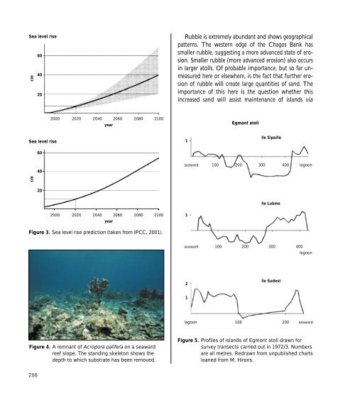
- Page 205 and 206: Figure 9. Eroded rim of the island
- Page 207 and 208: Sheppard, C. R. C., (1999b) ‘Cora
- Page 209 and 210: Table 1. Overview of the 40 coral r
- Page 211 and 212: Transects were placed at an oblique
- Page 213 and 214: RESULTS Scleractinian Live Hard Cor
- Page 215 and 216: Mean % live hard coral cover 10 5 0
- Page 217 and 218: partly confounded due to the signif
- Page 219 and 220: Table 6a. (continued) Type Site No.
- Page 221 and 222: Table 6a. (continued) Type Site No.
- Page 223 and 224: Figure 15. Recent Acropora sp. recr
- Page 225 and 226: sampled was calculated at 9.4 + 0.4
- Page 227 and 228: Harriott, V. J., & Fisk, D. A., (19
- Page 229 and 230: growth, and to recover reef habitat
- Page 231 and 232: The quantified fish surveys on the
- Page 233 and 234: cussed on obtaining a video record
- Page 235 and 236: arely exposed at low tide, and are
- Page 237 and 238: 50 Outer reef families 40 Percent 3
- Page 239 and 240: 7241 86 14 0 950 24 72 4 81 93 1437
- Page 241 and 242: that there may have been several co
- Page 243 and 244: Roberts, C. M., Hawkins, J. P., McA
- Page 245 and 246: Economic Analysis of Coral Bleachin
- Page 247 and 248: Table 1. Comparison of cost and ben
- Page 249 and 250: changes. In the Seychelles case stu
- Page 251 and 252: ents questioned in Zanzibar came in
- Page 253 and 254:
Table 3. Regression results for res
- Page 255 and 256:
Table 5. WTP Estimates for Kenya, Z
- Page 257 and 258:
Coral Reef Rehabilitation: Feasibil
- Page 259 and 260:
Since Kiunga is remote, with low or
- Page 261 and 262:
4000 Pavona spp. 4000 Porites spp.
- Page 263 and 264:
DISCUSSION AND CONCLUSIONS Recruits
- Page 265 and 266:
Obura, D. O., Uku, J. N., Wawiye, O
- Page 267 and 268:
such as increased penetration of so
- Page 269 and 270:
Table 1. Filter specifications for
- Page 271 and 272:
Table 2. The percentage cover of th
- Page 273 and 274:
Adresses to Authors S. Ahamada BP 1
- Page 275 and 276:
Jelvas M. Mwaura CORDIO East Africa