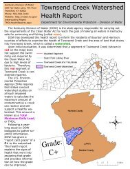
Example Flood Risk Report
Example Flood Risk Report
Example Flood Risk Report

Create successful ePaper yourself
Turn your PDF publications into a flip-book with our unique Google optimized e-Paper software.
HAZUS estimated loss data can be<br />
used in many ways to support local<br />
decision making and explaining<br />
flood risk. For mitigation planning<br />
purposes, loss data can be used to<br />
help meet requirements to develop<br />
loss information for the hazard of<br />
flood. Also, the FRM can show<br />
where flood risk varies by<br />
geographic location. For<br />
emergency management, HAZUS<br />
data can help forecast losses<br />
based on predicted events and the<br />
assignment of resources can be<br />
made accordingly. Loss<br />
information can support floodplain<br />
management efforts, including<br />
those to adopt higher regulatory<br />
standards. Also, awareness of<br />
exposed essential facilities and<br />
infrastructure encourages<br />
mitigation actions to protect<br />
citizens from service disruption<br />
should flooding occur.<br />
HAZUS estimated loss data is<br />
summarized in the FRR and on the<br />
FRM, and stored in the FRD.<br />
Allows analysis refinement though updating inventory data, and integrating<br />
data produced using other flood models<br />
Widely available support documents and networks (HAZUS Users Groups or<br />
HUGs)<br />
Files from the FRD can be imported into HAZUS-MH to develop other risk<br />
assessment information including:<br />
Debris generated after a flood event<br />
Dollar exposure of the agricultural products in a study region<br />
Exposure of the utility systems in the region<br />
Exposure of vehicles in the study region<br />
Damages and functionality of lifelines such as highway and rail bridges,<br />
potable water, and wastewater facilities<br />
The FRR primarily uses specific flood risk analysis methods which are<br />
summarized below:<br />
Scenario Loss Estimates: Scenario losses have been generated by HAZUS for<br />
four events: 10%, 2%, 1% and 0.2%. In the FRR, these losses are expressed in<br />
dollar amounts and are provided for the project study area only, even though<br />
results are shown watershed wide and at the local jurisdiction level.<br />
Loss estimates are based on best available data, and the methodologies applied<br />
result in an approximation of risk. These estimates should be used to<br />
understand relative risk from flood and potential losses. Uncertainties are<br />
inherent in any loss estimation methodology, arising in part from<br />
approximations and simplifications that are necessary for a comprehensive<br />
analysis (e.g., incomplete inventories, demographics, or economic parameters).<br />
<strong>Flood</strong> loss estimates are being provided at the project and at the community<br />
level for multiple flood frequencies including:<br />
Residential Asset Loss – These include direct building losses (estimated costs<br />
to repair or replace the damage caused to the building) for all classes of<br />
residential structures including single family, multi-family, manufactured<br />
housing, group housing, and nursing homes. This value also includes<br />
content losses.<br />
Commercial Asset Loss – These include direct building losses for all classes<br />
of commercial buildings including retail, wholesale, repair, professional<br />
services, banks, hospitals, entertainment, and parking facilities. This value<br />
also includes content and inventory losses.<br />
Other Asset Loss – This includes losses for facilities categorized as industrial,<br />
agricultural, religious, government, and educational . This value also<br />
includes content and inventory losses.<br />
DRAFT – WATERSHED USA FLOOD RISK REPORT 11