spring 04 / 17:1 - Grand Canyon River Guides
spring 04 / 17:1 - Grand Canyon River Guides
spring 04 / 17:1 - Grand Canyon River Guides

Create successful ePaper yourself
Turn your PDF publications into a flip-book with our unique Google optimized e-Paper software.
Historic Inscriptions At Lees Ferry<br />
Lees Ferry has truly been the crossroads of the<br />
canyon country when taking into account both<br />
river travel up and down the Colorado and overland<br />
travel between Utah and Arizona. It is located at<br />
the mouth of the Paria <strong>River</strong> where, for a ways, the<br />
confining walls break down and lower between the foot<br />
of Glen <strong>Canyon</strong> upstream and Marble Gorge downstream.<br />
This has long made it the primary crossing place<br />
of the Colorado <strong>River</strong> between what is now Moab,<br />
known is the old Lees Ferry fort. Situated facing towards<br />
the river, it is only a few paces north of today’s parking<br />
lot and concrete boat-launch ramp. The one-story, stone<br />
building was constructed in the summer of 1874 by the<br />
Mormon Church to serve as a combination trading store<br />
and fortification for dealings with the Navajo Indians<br />
across the Colorado to the south.<br />
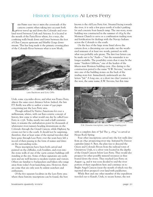
On the face of the large stone lintel above the<br />
eastern door, a discerning eye can make out the weathered<br />
remnant of at least two words, painted on with<br />
what was probably axle grease. The first four letters can<br />
be made out to be “Andr—,” but the remainder is no<br />
longer readable. The possibility exists that it may be the<br />
name “Andrew Gibbons,” one of the leaders of the<br />
fifteen-man Mormon building crew. Also dating to the<br />
construction period is the name “E.W. Stevens,” incised<br />
into one of the building stones on the back of the<br />
trading store-fort. Immediately underneath are the<br />
letters “Jul.” A long one, or a short two days’ journey to<br />
the west, the same name, E.W. Stevens, but this time<br />
Lees Backbone and Echo Cliffs<br />
Utah, some 279 miles above, and what was Pearce Ferry,<br />
almost the same exact distance below. Indeed, the late<br />
P.T. Reilly was able to author a tome of 542 pages<br />
concerning just the Lees Ferry area.<br />
Though utilized by Native Americans for over a<br />
millennium, whites, with our Euro-centric concept of<br />
history, first came to what would one day be called Lees<br />
Ferry in <strong>17</strong>76. Today, nearly two-and-a-half centuries<br />
later, it remains the embarkation point for thousands of<br />
whitewater river-runners heading downstream on the<br />
Colorado through the <strong>Grand</strong> <strong>Canyon</strong>, while Highway 89<br />
crosses not far to the south. It should not be surprising,<br />
therefore, that at least some of the myriad travelers that<br />
have gone through Lees Ferry over the years have left a<br />
record of their passing in the form of names and dates<br />
on the surrounding rocks.<br />
These inscriptions have been both carved and<br />
painted on the cliffsides, rock boulders, and even into<br />
the stone walls of one of the 19th century buildings still<br />
standing at the site. Some of these signatures are easily<br />
seen and are well known to modern tourists and visitors.<br />
Others are familiar to backpackers and hikers who range<br />
away from today’s boat-launching area. However, there<br />
are some that are only seen by ardent searchers and<br />
enthusiasts.<br />
Of the five separate localities in the Lees Ferry area<br />
where these historic inscriptions can be found, the best<br />
E.W. Stevens inscription, Lees Ferrey trading post<br />
with a complete date of “Jul The 3, 1874,” is carved at<br />
House Rock Spring.<br />
Four other inscriptions carved into the fort walls date<br />
from an 1891 prospecting-river trip. Initiated by Denver<br />
capitalist James S. Best, the plan was to descend the<br />
Green and Colorado <strong>River</strong>s from the railroad town of<br />
Greenriver, Utah, to a silver vein located in the depths<br />
of the <strong>Grand</strong> <strong>Canyon</strong> below Lees Ferry. They would also<br />
prospect for other possible mineral resources as they<br />
boated down the rivers. They reached Lees Ferry on<br />
August 14, and it was soon decided to end the river<br />
portion of their expedition here and continue on to<br />
Bright Angel <strong>Canyon</strong> (near the mouth of which was the<br />
reported silver prospect) over land with packhorses.<br />
While Best and one other member of the expedition<br />
traveled out to Kanab, Utah, to secure horses, the rest<br />
boatman’s quarterly review page 21