Storms, Floods, and the Science of Atmospheric Rivers
Storms, Floods, and the Science of Atmospheric Rivers
Storms, Floods, and the Science of Atmospheric Rivers

Create successful ePaper yourself
Turn your PDF publications into a flip-book with our unique Google optimized e-Paper software.
explored <strong>the</strong> physical characteristics <strong>and</strong><br />
effects <strong>of</strong> ARs, focused mostly over <strong>the</strong> eastern<br />
Pacific Ocean <strong>and</strong> western North America<br />
(a bibliography <strong>of</strong> AR- related research<br />
papers <strong>and</strong> many additional resources on<br />
ARs are available at http://www.esrl.noaa<br />
.gov/psd/ atmrivers/). Research aircraft observations<br />
in two ARs above <strong>the</strong> eastern North<br />
Pacific in <strong>the</strong> winters <strong>of</strong> 1998 <strong>and</strong> 2005 [Ralph<br />
et al., 2005, 2011] showed that <strong>the</strong>y transported<br />
water vapor at about 13–26 cubic<br />
kilometers per day, a rate equivalent to 7.5–<br />
15 times <strong>the</strong> average daily discharge <strong>of</strong> <strong>the</strong><br />
Mississippi River into <strong>the</strong> Gulf <strong>of</strong> Mexico.<br />
A Closer Look at Rainfall<br />
From <strong>Atmospheric</strong> <strong>Rivers</strong><br />
Because ARs transport so much water<br />
vapor, <strong>the</strong>y represent a significant source <strong>of</strong><br />
precipitation to coastal regions. For example,<br />
a recent numerical model study [Smith<br />
et al., 2010] estimated that roughly 20–40%<br />
<strong>of</strong> <strong>the</strong> water vapor transported ashore by<br />
an AR crossing over nor<strong>the</strong>rn California<br />
was rained out <strong>the</strong>re. This rainout happens<br />
because when ARs make l<strong>and</strong>fall on <strong>the</strong><br />
West Coast <strong>of</strong> North America (as well as on<br />
o<strong>the</strong>r continents [e.g., Stohl et al., 2008]),<br />
<strong>the</strong>y are forced up <strong>and</strong> over coastal mountains,<br />
where <strong>the</strong>y cool <strong>and</strong> condense large<br />
parts <strong>of</strong> <strong>the</strong>ir heavy burden <strong>of</strong> vapor [e.g.,<br />
Neiman et al., 2008; Leung <strong>and</strong> Qian, 2009].<br />
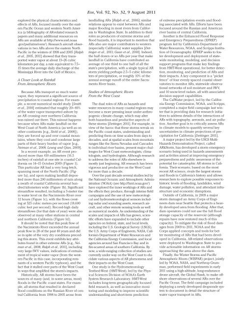
In a recent example, an AR event produced<br />
more than 410 millimeters (16.5<br />
inches) <strong>of</strong> rainfall at one site in coastal California<br />
on 14–15 October 2009 (Figure 1).<br />
This particular AR had a very long fetch,<br />
spanning most <strong>of</strong> <strong>the</strong> North Pacific (Figure<br />
1a), <strong>and</strong> upon making l<strong>and</strong>fall deposited<br />
more than 200 millimeters <strong>of</strong> rain along<br />
a swath <strong>of</strong> coastal California several hundred<br />
kilometers wide (Figure 1b). Significant<br />
streamflow resulted, including a 5- meter rise<br />
in water level on <strong>the</strong> Nacimiento River over<br />
12 hours (Figure 1c), with <strong>the</strong> flows cresting<br />
at 525 cubic meters per second (18,600<br />
cubic feet per second). Record- high daily<br />
streamflows (for that date <strong>of</strong> year) were also<br />
observed at many o<strong>the</strong>r stations in central<br />
<strong>and</strong> nor<strong>the</strong>rn California (Figure 1d).<br />
It should be noted that this peak flow <strong>of</strong><br />
<strong>the</strong> Nacimiento River exceeded <strong>the</strong> annual<br />
peak flow in 28 <strong>of</strong> <strong>the</strong> past 40 years <strong>and</strong> did<br />
so in spite <strong>of</strong> <strong>the</strong> very dry conditions preceding<br />
this storm. This event exhibits key attributes<br />
found in o<strong>the</strong>r extreme ARs [e.g., Neiman<br />
et al., 2008; Ralph et al., 2011], including<br />
very large IWV values, indications <strong>of</strong> entrainment<br />
<strong>of</strong> tropical water vapor (from <strong>the</strong> western<br />
Pacific in this case, incorporating remnants<br />
<strong>of</strong> a western Pacific typhoon), <strong>and</strong> <strong>the</strong><br />
fact that it stalled over parts <strong>of</strong> <strong>the</strong> West Coast<br />
in ways that amplified <strong>the</strong> storm’s impacts.<br />
Historically, AR storms have been <strong>the</strong><br />
sources <strong>of</strong> many (<strong>and</strong>, in some areas, most)<br />
floods in <strong>the</strong> Pacific coast states. For example,<br />
all storms that resulted in declared<br />
flood conditions on <strong>the</strong> Russian River <strong>of</strong> central<br />
California from 1998 to 2005 arose from<br />
Eos, Vol. 92, No. 32, 9 August 2011<br />
l<strong>and</strong>falling ARs [Ralph et al., 2006]; similar<br />
relations appear to exist between ARs <strong>and</strong><br />
major flooding in most rivers from California<br />
to Washington State. In addition to <strong>the</strong>ir<br />
roles as producers <strong>of</strong> extreme storms <strong>and</strong><br />
flood hazards, it is important to mention that<br />
ARs also are major contributors to western<br />
(especially California) water supplies [Dettinger<br />
et al., 2011; Guan et al., 2010]. Indeed,<br />
<strong>the</strong> half dozen or so ARs per year that make<br />
l<strong>and</strong>fall in California have contributed an<br />
average <strong>of</strong> one third to one half <strong>of</strong> all <strong>the</strong><br />
state’s precipitation, with a single typical AR<br />
storm yielding perhaps 2.5–5 cubic kilometers<br />
<strong>of</strong> precipitation, or roughly 10% <strong>of</strong> <strong>the</strong><br />
annual average run<strong>of</strong>f <strong>of</strong> <strong>the</strong> entire Sacramento<br />
River basin.<br />
Studies <strong>of</strong> <strong>Atmospheric</strong> <strong>Rivers</strong><br />
From <strong>the</strong> West Coast<br />
The dual roles <strong>of</strong> ARs as hazards <strong>and</strong><br />
water resources in many coastal regions may<br />
become a more pressing issue under anthropogenic<br />
climate change, which may alter<br />
both hazardous <strong>and</strong> productive aspects <strong>of</strong><br />
<strong>the</strong>se storms [Dettinger, 2011]. For example, in<br />
view <strong>of</strong> <strong>the</strong> havoc that <strong>the</strong>se storms wreak on<br />
<strong>the</strong> Pacific coast states, underst<strong>and</strong>ing <strong>and</strong><br />
predicting <strong>the</strong>m on time scales from days to<br />
decades, <strong>and</strong> at spatial scales from mountain<br />
ranges like <strong>the</strong> Sierra Nevadas <strong>and</strong> Cascades<br />
to individual river basins, present major challenges<br />
for West Coast meteorologists, climatologists,<br />
<strong>and</strong> hydrologists. Although research<br />
to address <strong>the</strong> roles <strong>of</strong> ARs elsewhere is<br />
mostly just beginning, AR research has been<br />
vigorous <strong>and</strong> productive on <strong>the</strong> West Coast<br />
for more than a decade.<br />
Over <strong>the</strong> past decade several studies led by<br />
<strong>the</strong> National Oceanic <strong>and</strong> <strong>Atmospheric</strong> Administration<br />
(NOAA) (see http://hmt.noaa.gov/)<br />
have explored <strong>the</strong> inner workings <strong>of</strong> ARs <strong>and</strong><br />
<strong>the</strong> effects <strong>the</strong>y produce, through intense field<br />
campaigns <strong>and</strong> <strong>the</strong> use <strong>of</strong> new meteorological<br />
<strong>and</strong> hydrometeorological sensors including<br />
radar <strong>and</strong> sounding assets, research aircraft,<br />
<strong>and</strong> o<strong>the</strong>r remote sensing tools as well<br />
as numerical models. As underst<strong>and</strong>ing <strong>of</strong> <strong>the</strong><br />
scales <strong>and</strong> impacts <strong>of</strong> ARs has grown, scientific<br />
efforts have exp<strong>and</strong>ed to include o<strong>the</strong>r<br />
agencies on federal, state, <strong>and</strong> local levels,<br />
including <strong>the</strong> U.S. Geological Survey (USGS),<br />
<strong>the</strong> U.S. Army Corps <strong>of</strong> Engineers, NASA, California’s<br />
Department <strong>of</strong> Water Resources <strong>and</strong><br />
<strong>the</strong> California Energy Commission, <strong>and</strong> local<br />
agencies around San Francisco Bay <strong>and</strong> in<br />
fire- scarred areas <strong>of</strong> sou<strong>the</strong>rn California. By<br />
now, a wide- ranging collection <strong>of</strong> studies are<br />
currently under way on <strong>the</strong> West Coast to elucidate<br />
various aspects <strong>of</strong> AR phenomena <strong>and</strong><br />
<strong>the</strong>ir impacts on <strong>the</strong> West Coast.<br />
One study is <strong>the</strong> Hydrometeorology<br />
Testbed- West (HMT- West), led by <strong>the</strong> Physical<br />
<strong>Science</strong>s Division <strong>of</strong> NOAA’s Earth<br />
System Research Laboratory. HMT- West<br />
includes long- term geographically focused<br />
field research, as well as innovative monitoring<br />
<strong>and</strong> modeling to improve scientific<br />
underst<strong>and</strong>ing <strong>and</strong> short- term prediction<br />
<strong>of</strong> extreme precipitation events <strong>and</strong> flooding<br />
associated with ARs. Efforts have been<br />
focused around <strong>the</strong> Russian <strong>and</strong> American<br />
river basins <strong>of</strong> central California.<br />
Ano<strong>the</strong>r is <strong>the</strong> Enhanced Flood Response<br />
<strong>and</strong> Emergency Preparedness (EFREP)<br />
program led by California’s Department <strong>of</strong><br />
Water Resources, NOAA, <strong>and</strong> Scripps Institution<br />
<strong>of</strong> Oceanography. EFREP seeks to foster<br />
development <strong>and</strong> deployment <strong>of</strong> statewide<br />
monitoring, modeling, <strong>and</strong> decision<br />
support programs that make key findings<br />
from HMT- West operational, for better detection,<br />
monitoring, <strong>and</strong> prediction <strong>of</strong> ARs <strong>and</strong><br />
<strong>the</strong>ir impacts. A key component is a “picket<br />
fence” <strong>of</strong> four evenly spaced coastal observatories<br />
to monitor ARs, statewide observational<br />
networks <strong>of</strong> soil moisture <strong>and</strong> IWV,<br />
<strong>and</strong> 10 snow- level radars, all with associated<br />
decision support capabilities.<br />
The CalWater project, led by <strong>the</strong> California<br />
Energy Commission, NOAA, <strong>and</strong> Scripps,<br />
completed a major field campaign last winter<br />
that is providing data for research initiatives<br />
to address details <strong>of</strong> <strong>the</strong> interactions <strong>of</strong><br />
ARs with topography, aerosols, <strong>and</strong> air pollution.<br />
Ano<strong>the</strong>r goal is to critically assess ARs<br />
in climate models to quantify several key<br />
uncertainties in climate projections <strong>of</strong> precipitation<br />
for California [Dettinger, 2011].<br />
A major project led by <strong>the</strong> USGS Multi-<br />
Hazards Demonstration Project, called<br />
ARkStorm, has developed a storm emergency<br />
scenario being used in hazards assessments<br />
<strong>and</strong> activities aimed at improving emergency<br />
preparedness <strong>and</strong> public awareness <strong>of</strong> <strong>the</strong><br />
potential for catastrophic AR storms in California.<br />
Their scenario, based on <strong>the</strong> most<br />
recent AR science, rivals <strong>the</strong> largest storms<br />
<strong>and</strong> floods in California’s history <strong>and</strong> allows<br />
researchers to explore possible responses to<br />
historic levels <strong>of</strong> flooding, l<strong>and</strong>slides, wind<br />
damage, water pollution, <strong>and</strong> attendant infrastructure<br />
<strong>and</strong> economic disruptions.<br />
Outside <strong>of</strong> California, in 2009 a major<br />
storm damaged an Army Corps <strong>of</strong> Engineers<br />
dam near Seattle that protects a heavily<br />
developed area from flooding. After that,<br />
dam operators could not use <strong>the</strong> full flood<br />
storage capacity <strong>of</strong> <strong>the</strong> reservoir (although<br />
repairs have now restored much <strong>of</strong> this<br />
capacity). To mitigate <strong>the</strong> risk <strong>of</strong> flood damages<br />
from 2009 to 2011, NOAA <strong>and</strong> <strong>the</strong><br />
Corps applied concepts <strong>and</strong> tools for better<br />
monitoring <strong>of</strong> ARs that had been developed<br />
in California. AR-related observations<br />
were deployed to Washington State to provide<br />
actionable information on AR storms<br />
approaching <strong>the</strong> area above <strong>the</strong> dam.<br />
Finally, <strong>the</strong> Winter <strong>Storms</strong> <strong>and</strong> Pacific<br />
<strong>Atmospheric</strong> <strong>Rivers</strong> (WISPAR) project, jointly<br />
led by NOAA, NASA, <strong>and</strong> Northrop Grumman,<br />
performed field experiments in early<br />
2011 using a high- altitude, long- endurance<br />
drone aircraft, <strong>the</strong> Global Hawk, to make <strong>of</strong>fshore<br />
observations <strong>of</strong> several ARs over <strong>the</strong><br />
Pacific Ocean. The field campaign included<br />
deploying a newly developed dropsonde system<br />
to document in detail <strong>the</strong> structure <strong>of</strong><br />
water vapor transport in ARs.