Abe's Run Wetland - Canaan Valley Institute
Abe's Run Wetland - Canaan Valley Institute
Abe's Run Wetland - Canaan Valley Institute

Create successful ePaper yourself
Turn your PDF publications into a flip-book with our unique Google optimized e-Paper software.
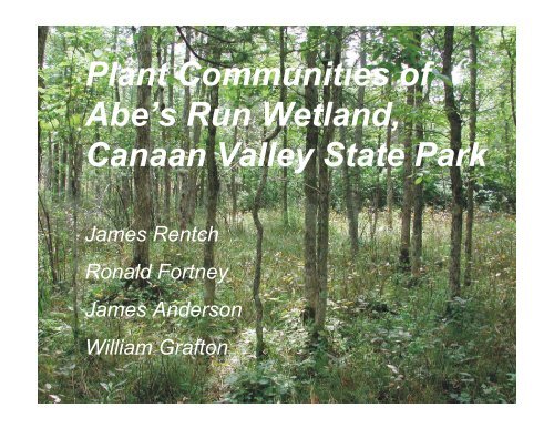
Plant Communities of<br />
Abe’s <strong>Run</strong> <strong>Wetland</strong>,<br />
<strong>Canaan</strong> <strong>Valley</strong> State Park<br />
James Rentch<br />
Ronald Fortney<br />
James Anderson<br />
William Grafton
Abe’s <strong>Run</strong> <strong>Wetland</strong><br />
• 33 ha wetland<br />
• 148 ha watershed<br />
• Within <strong>Canaan</strong> <strong>Valley</strong> State Park<br />
• All major wetland vegetative-cover types<br />
present<br />
• Known location for several rare plants<br />
• Contact point for Greenbrier limestone
Study Objectives:<br />
• Vegetative sampling along 6 transects<br />
during July-August, 2002<br />
• Hydrologic sampling from 24 groundwater<br />
monitoring wells, April-August, 2002<br />
• Soil sampling along six vegetation<br />
transects<br />
• Overstory tree establishment trends<br />
• Changes in vegetation cover, 1945-2000
Transect Locations:<br />
To Lodge<br />
To WV<br />
Rt. 32
Vegetation Sampling Methods<br />
50 m<br />
5m<br />
20 m<br />
Herbs - Cover classes in 1 X 1 m subplots<br />
Shrubs - Stem counts in 5 X 5 m subplots<br />
Saplings [dbh1 m] - Complete tally by species<br />
Trees [dbh>10 cm] and small trees [2.5cm
Vegetation Data Analysis<br />
• Herbs IV = [Rel. Cov. + Rel. Freq.]/2<br />
• Shrubs/tall seedlings, Saplings = Stems ha -1<br />
• Small tree IV = [Rel. B.A. + Rel. Abund.]/2<br />
• Large tree IV = [Rel. B.A. + Rel. Abund.]/2
Changes in Post-logging Era<br />
Vegetation, 1945-2000<br />
• 1945 (BW, USDA) and 1997 (CIR, NAPP)<br />
aerial photographic coverages used<br />
• Watershed mapped by vegetative cover<br />
class [Cowardin et al. (1979), EPIC (1992)]<br />
• Evaluation of changes in vegetation cover<br />
class totals between 1945-2000, using<br />
Krushall-Wallis test [α=0.05]
Results: Vegetation Summary<br />
• 179 vascular plant species<br />
145 herbs [46 grasses and sedges]<br />
34 woody species [12 trees, 22 shrubs]<br />
23 exotic species<br />
5 species occurred in all 6 transects, 35<br />
species occurred once<br />
38 species at/near southernmost known<br />
station<br />
• 28 bryophytes<br />
24 mosses<br />
4 liverworts
8/1<br />
-10<br />
0<br />
10<br />
20<br />
30<br />
40<br />
Results: Depth to Groundwater<br />
4/11<br />
4/25<br />
5/9<br />
5/23<br />
6/6<br />
6/20<br />
7/4<br />
7/18<br />
T1 T2 T3<br />
T4 T5 T6<br />
Depth to water table (cm)
Results: Soil Horizon Depth<br />
Depth (cm)<br />
0<br />
20<br />
40<br />
60<br />
80<br />
100<br />
120<br />
Tran1 Tran2 Tran3 Tran4 Tran5 Tran6<br />
O A B C
Transect 1
Transect 1<br />
• Vegetation structure: PEM1<br />
• Dominant herbs: Carex atlantica, Leersia<br />
oryzoides, Scirpus tabernaemontani<br />
• Shrub: Rhododendron maximum<br />
– All: 800 stems ha -1<br />
• Small tree: Picea rubens<br />
– All: 306 trees ha -1 , 0.6 m 2 ha -1<br />
• Large tree: Betula allegheniensis, Tsuga<br />
canadensis<br />
– All: 285 trees ha -1 , 8.0 m 2 ha -1
Transect 2
Transect 2<br />
• Vegetation structure: PEM1<br />
• Dominant herbs: Euthamia graminifolia,<br />
Dennstaedtia punctilobula, Dryopteris intermedia,<br />
Osmunda cinnamomea<br />
• Shrub: Rubus allegheniensis<br />
– All: 371 stems ha -1<br />
• Small tree: Picea rubens<br />
– All: 139 trees ha -1 , 0.3 m 2 ha -1<br />
• Large tree: Betula allegheniensis, Tsuga.<br />
canadensis<br />
– All: 42 trees ha -1 , 3.0 m 2 ha - 1
Transect 3
Transect 4
Transect 6
Transects 3, 4, 6<br />
• Vegetation structure: PFO8<br />
• Dominant herbs: Caltha palustris, Senecio<br />
aureus, Glyceria striata [Geum rivale, Carex<br />
bromoides, Euphorbia purpurea, Polemonium<br />
van-bruntiae,Listera smallii, Equisetum<br />
sylvaticum, Saxifrage pensylvanica]<br />
• Shrub: Rhamnus alnifolia, Ilex verticillata,<br />
Alnus incana, Salix discolor, Viburnum<br />
lentago, [Viburnum opulus var. americana]<br />
– Average: 46,311 stems ha -1
Transects 3, 4, 6 -- continued<br />
• Small tree: Abies balsamea, Fraxinus nigra,<br />
Betula allegheniensis, Tsuga canadensis<br />
– Average: 267 trees ha -1 , 1.1 m 2 ha -1<br />
• Large trees: Betula allegheniensis, Fraxinus<br />
nigra, Tsuga canadensis, Abies balsamea<br />
– Average: 436 trees ha -1 , 11.0 m 2 ha -1
Transect 5
Transect 5<br />
• Vegetation structure: PFO8<br />
• Dominant herbs: Impatiens capensis, Carex<br />
bromoides, Carex gynandra, Glyceria striata<br />
[Geum rivale, Euphorbia purpurea, Polemonium<br />
van bruntiae]<br />
• Shrub: Ilex verticillata, Alnus incana<br />
– All: 12,880 stems ha -1<br />
• Small tree: A. balsamea, B. allegheniensis<br />
– All: 187 trees ha -1 , 0.9 m 2 ha -1<br />
• Large tree: F. nigra, A. balsamea, T. canadensis<br />
– All: 477 trees ha -1 , 11.0 m 2 ha -1
Establishment years for wetland<br />
overstory trees<br />
20<br />
balsam fir black ash hemlock red spruce<br />
15<br />
dbh (cm)<br />
10<br />
5<br />
0<br />
1750 1800 1850 1900 1950 2000<br />
establishment year (at dbh)
Changes in Vegetative Cover-Type<br />
1945-2000 [χ 2 = 1.06, p = 0.18]<br />
100<br />
16<br />
75<br />
1945<br />
12<br />
Area (ha)<br />
50<br />
2000<br />
8<br />
25<br />
4<br />
0<br />
UHU UFO1 UFO4 UFO8 USS1<br />
0<br />
PEM1 PFO4 PFO8 PSS1<br />
Uplands<br />
<strong>Wetland</strong>s
Changes in Vegetative Cover-Type in<br />
Watershed - 1945-2000<br />
• Watershed:<br />
– 30% decline in herbaceous cover<br />
– Increases in upland forested and scrubshrub<br />
areas<br />
• <strong>Wetland</strong>:<br />
– 50% decline in coniferous swamp forests<br />
– Increases in wet-graminoid and scrub-shrub<br />
• Impacts of beaver<br />
• Impacts of balsam wooly adelgid<br />
• Impacts of white-tailed deer
Summary: Abe’s <strong>Run</strong> wetland—an<br />
area of exceptional plant diversity<br />
• Characteristics common to <strong>Canaan</strong><br />
<strong>Valley</strong> as a whole<br />
• Non-continuous tree, small tree, and<br />
shrub vegetation structure<br />
• Variable hydrologic regime<br />
• Juxtaposition of acid and alkaline<br />
substrate<br />
• Relative degree of community stability<br />
and absence of destructive slash fires<br />
following logging