Field trip North Sea â Hallig Hooge - Coastal-Change.Org
Field trip North Sea â Hallig Hooge - Coastal-Change.Org
Field trip North Sea â Hallig Hooge - Coastal-Change.Org

Create successful ePaper yourself
Turn your PDF publications into a flip-book with our unique Google optimized e-Paper software.
<strong>Field</strong> <strong>trip</strong> <strong>North</strong> <strong>Sea</strong> – <strong>Hallig</strong> <strong>Hooge</strong><br />
5 th September 2012<br />
The 3rd joint IGCP588 / INQUA 1001 conference<br />
Christian-Albrechts-University Kiel<br />
04.09.2012 – 10.09.2012<br />
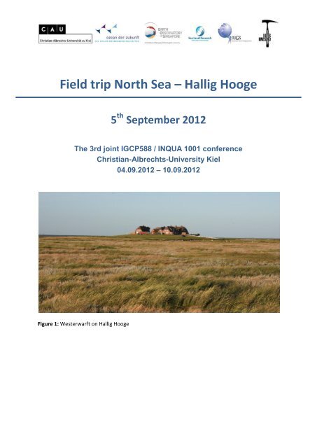
Figure 1: Westerwarft on <strong>Hallig</strong> <strong>Hooge</strong>
<strong>Field</strong> guide <strong>North</strong> <strong>Sea</strong> – <strong>Hallig</strong> <strong>Hooge</strong> 05.09.20121<br />
Written by:<br />
Dr. Matthias Deicke<br />
Dipl. Geogr. Malte Schindler<br />
Stud. BSc. Geosc. Anna Arsenijevic<br />
Guidance on the tidal flats:<br />
Anna Arsenijevic<br />
Georg-August-Universität Göttingen<br />
Geoscience Center Göttingen<br />
Dep. Sedimentology/Environmental Geology<br />
Goldschmidtstraße 3<br />
D - 37077 Göttingen<br />
Mail to:<br />
mdeicke@gwdg.de<br />
malte.schindler@geo.uni-goettingen.de<br />
anna.arsenijevic@googlemail.com<br />
Conference contact:<br />
Prof. Dr. Karl Stattegger<br />
Dr. Klaus Schwarzer<br />
Christian-Albrechts-University Kiel<br />
Institute of Geosciences<br />
Sedimentology, <strong>Coastal</strong> and Continental Shelf Research<br />
Otto Hahan Platz 3<br />
24118 Kiel<br />
http://www.gpi.uni-kiel.de/Sedimentologie/<br />
2
<strong>Field</strong> guide <strong>North</strong> <strong>Sea</strong> – <strong>Hallig</strong> <strong>Hooge</strong> 05.09.20121<br />
1 Technical information 5 th September 2012<br />
1.1 Time schedule<br />
10:00 to 11:15 Ferry from Schlüttsiel to <strong>Hallig</strong> <strong>Hooge</strong><br />
11:15 Pick up our bicycles<br />
11:15 to 12:30 Guided <strong>trip</strong> to the tidal flat surrounding <strong>Hallig</strong> <strong>Hooge</strong><br />
13:00 Hanswarft and Schutzstation Wattenmeer e.V.<br />
13:45 Test sites of the research project SAHALL II<br />
(Sediment Accumulation HALLigen)<br />
14:15 Visit of the church (Kirchwarft) and storm surge pale<br />
14:45 Coffee and tea break in the historic inn “Blauer Pesel”<br />
15:45 to 17:00 Ferry back to Schlüttsiel<br />
1.2 General information<br />
Please, consider possible unstable weather and take some rainwear. Concerning the <strong>trip</strong> to<br />
the tidal flats it is common to walk barefooted. Feet can be cleaned with fresh water after<br />
the walk. Only a very limited amount of rubber boots can be provided by the “Schutzstation<br />
Wattenmeer e.V.”.<br />
3
<strong>Field</strong> guide <strong>North</strong> <strong>Sea</strong> – <strong>Hallig</strong> <strong>Hooge</strong> 05.09.20121<br />
2 The <strong>North</strong> Frisian Wadden <strong>Sea</strong><br />
2.1 Overview<br />
Located witin the German Bight and extending from the Netherlands in the West to<br />
Denmark in the <strong>North</strong> the Wadden <strong>Sea</strong> is an unique area of micro- to macrotidal conditions<br />
with barrier islands, large tidal flats, estuaries and tidal channels. With an area of<br />
approximately 9000 km 2 it is the largest tidal flat of the world in the temperate zone. Though<br />
the Wadden <strong>Sea</strong> itself is mainly affected by natural processes, the coastline is mostly formed<br />
by man. Due to the unique habitat characteristics a variety of highly specialized organisms<br />
create a complex ecosystem. As the high primary production rate of the Wadden <strong>Sea</strong> is very<br />
high the area provides nutrition for millions of fish and birds. The Wadden <strong>Sea</strong> of Schleswig-<br />
Holstein became a National Park in 1985. In 2009 the entire Wadden <strong>Sea</strong> of Schleswig-<br />
Holstein, Lower Saxony and the Netherlands was nominated as UNESCO World Heritage.<br />
<strong>North</strong> <strong>Sea</strong><br />
x Schlüttsiel<br />
x <strong>Hooge</strong><br />
Figure 2 (left): Satellite image of the German <strong>North</strong> <strong>Sea</strong> coast. The tidal flats between MLW-line and<br />
mainland can be seen clearly (Source: HZG). Figure 3 (right): Satellite image of the <strong>North</strong> Frisian<br />
Wadden <strong>Sea</strong> and the <strong>Hallig</strong>en.<br />
4
<strong>Field</strong> guide <strong>North</strong> <strong>Sea</strong> – <strong>Hallig</strong> <strong>Hooge</strong> 05.09.20121<br />
2.2 Regional geography and geology<br />
The latest period of landscape evolution of the <strong>North</strong> Frisian Wadden <strong>Sea</strong> started at the end<br />
of the weichselian glacial period. Melt water streams delivered vast amounts of sediments<br />
from eastward directions onto the area. In the holocene a sea level rise of approx. 60 m took<br />
place triggerd by eustatic processes. During the Calais- and Dünkirchen transgressions, thick<br />
sediment layers (up to more than 30m) accumulated on the former pleistocene surface.<br />
7.000 yr BP the rate of sea level rise decreased significantly. Short periods of regression<br />
occurred, forming peat and brackish sediments. Older sediments of the Saalian glacial peroid<br />
westward of the islands Sylt, Amrum and Eiderstedt temporarily protected the area of the<br />
Wadden <strong>Sea</strong> against the ocean.<br />
Figure 4: Map of the <strong>North</strong> Frisian<br />
Wadden <strong>Sea</strong>. The ten <strong>Hallig</strong>en<br />
(underlined) are islands with only<br />
low or no protecting<br />
embankment. The marsh islands<br />
Pellworm and Nordstrand in<br />
contrast are surrounded by a<br />
dyke.<br />
The contemporary appearance of the <strong>North</strong> Frisian Wadden <strong>Sea</strong> and the coastline was<br />
formed by a number of catastrophic storm surges and by land reclamation activities. About<br />
1000 yr BP, the coastal residents started to build up dykes and intensitied peat digging<br />
activities. Two surge events the so called 1 st and 2 nd “Grote Mandränke (drowning of many<br />
people ‘man’) had a major impact to the landscape and happened in 1362 and 1634,. Dozens<br />
of small towns were destroyed and about 100.000 people died during both events. The<br />
today’s appearance of the <strong>North</strong> Frisian Wadden <strong>Sea</strong> is a direct consequence of the 2 nd<br />
“Grote Mandränke”. The former island “Strand” was split into “Nordstrand” and “Pellworm”.<br />
5
<strong>Field</strong> guide <strong>North</strong> <strong>Sea</strong> – <strong>Hallig</strong> <strong>Hooge</strong> 05.09.20121<br />
Major tidal channels formed, cutting into former marshland. Also the development of the<br />
<strong>Hallig</strong>en is related to those events.<br />
Figure 5: Historical map “Frisia Borealis in Ducatus Sleswicensi – Danimarca“, published in<br />
1665. Right side: <strong>North</strong> Frisian coast in 1240 before the 1 st “Mandränke”. Left side: Coast<br />
line after the 2 nd “Mandränke” in 1651.<br />
2.3 Biological diversity<br />
You can find a large number of organisms that are perfectly adapted to the ever changing<br />
living conditions of the Wadden <strong>Sea</strong>. These organisms have to cope with a variations of<br />
salinity, water temperature and water depth and numerous predators can easily catch them<br />
during low water. Amazing survival strategies been developed in consequence. A selection of<br />
organisms and adjustment mechanisms are presented during the tidal flat tour. The tidal<br />
flats and adjacent marsh areas act as feeding and resting places for thousands of migrants<br />
that attend the Wadden <strong>Sea</strong> twice a year during their flyways between the northern<br />
breeding areas and the southern wintering grounds. The huge production of biomass on the<br />
tidal flats enables a time effective recreation phase for the birds. Currently the birds are<br />
preparing themselves for the journey to the wintering grounds, so you may get the chance<br />
to observe some species in large swarms.<br />
6
<strong>Field</strong> guide <strong>North</strong> <strong>Sea</strong> – <strong>Hallig</strong> <strong>Hooge</strong> 05.09.20121<br />
3 The <strong>Hallig</strong>en<br />
3.1 Overview<br />
The <strong>Hallig</strong>en are small relicts of former marshland, that were not eroded by storm surges.<br />
Finally, 10 <strong>Hallig</strong>en have been preserved against the sea up to now. These small islands are a<br />
natural phenomenon, which is unique worldwide. Although the <strong>Hallig</strong>en are inhabited by<br />
around 300 residents, they have no or only low embankments. Consequently, the <strong>Hallig</strong>en<br />
are inundated up to 50 times a year (so called Landunter, Figure 7). In order to protect<br />
residents and properties the buildings are erected on dwelling mounds (so called Warften).<br />
Due to these environmental conditions a special lifestyle has been developed. Besides their<br />
socio-cultural relevancy, the <strong>Hallig</strong>en are of high ecological importance and are of major<br />
concern in coastal protection issues. Together with extended sand banks (-barriers) located<br />
westward of the <strong>Hallig</strong>en these act as wave-breakers to protect the mainland coast.<br />
Nowadays, the <strong>Hallig</strong>en have to deal with demographic changes and the consequences of<br />
climate change e.g. rising sea level.<br />
Figure 6: Touristic map of <strong>Hallig</strong> <strong>Hooge</strong><br />
<strong>Hallig</strong> <strong>Hooge</strong> is the best known of the ten <strong>North</strong> Frisian <strong>Hallig</strong>en. With an area of 5,5 km 2 , it<br />
offers a lot of opportunities to discover the customs and the culture of the <strong>Hallig</strong>. About 100<br />
habitants are living on 10 Warften, this makes <strong>Hallig</strong> <strong>Hooge</strong> one of the smallest independent<br />
communities in Germany. Nevertheless, it includes church, supermarket, school, youth<br />
camp, five pubs and restaurants and a large number of private guestrooms and holiday flats.<br />
Mudflat hiking, boat <strong>trip</strong>s and bird excursions bring pupils and tourists in touch with the<br />
7
<strong>Field</strong> guide <strong>North</strong> <strong>Sea</strong> – <strong>Hallig</strong> <strong>Hooge</strong> 05.09.20121<br />
variety and dynamics of the Wadden <strong>Sea</strong> ecosystem. Nowadays tourism is the major source<br />
of income for most of the inhabitants, but livestock farming and shoreline protection<br />
guarantees employment as well.<br />
3.2 Protection against storm surges<br />
From the end of the 19 th to the beginning of the 20 th century the shorelines of the <strong>Hallig</strong>en<br />
were only protected by block revetments. Without these protections against erosion they<br />
would not have been preserved up to now. Additionally, at the beginning of the 20 th century<br />
<strong>Hooge</strong> has been equipped with a low dyke in order to protect the <strong>Hallig</strong> against inundation<br />
during the summer months (summer dyke). The dyke allows a more intensive use of<br />
grassland and meadows. Still, in the stormy season from October to March the marshland is<br />
inundated by higher storm surges.<br />
Figure 7: Picture of <strong>Hallig</strong> Gröde from 1984. While huge parts are inundated, the Warften are still<br />
above sea level.<br />
During the 1980s local authorities started to construct higher water permeable revetments<br />
additional to the former non permeable block revetments seaward of the embankment.<br />
These constructions were established to decrease the erosive force of waves and thus to<br />
protect the dyke (Fig. 8). After a Landunter the <strong>Hallig</strong> is drained via ditches, channels and<br />
tidal gates.<br />
8
<strong>Field</strong> guide <strong>North</strong> <strong>Sea</strong> – <strong>Hallig</strong> <strong>Hooge</strong> 05.09.20121<br />
Figure 8: Elevated revetments at a beginning storm surge on the south shore of <strong>Hallig</strong> <strong>Hooge</strong><br />
Figure 9: A distant view on <strong>Hallig</strong> <strong>Hooge</strong>.<br />
The first Warften (Figure 1, 7 and 9) were constructed more than 2000 yr BP. Recently, their<br />
heights had to be raised due to the rising sea level. Lots of adjustments were conducted<br />
after the catastrophic storm sure event in 1962 and most of the houses had to be rebuilt.<br />
Additional adjustments were made after the heavy storm surges in 1976 and in 1981. The<br />
Warften were widened and Warft slopes flattened. Further on, the top of the Warften were<br />
surrounded by a small dyke. A shelter room was installed in the first floor of each home. Solid<br />
concrete pillars supporting this shelter room were deep seated in the ground soil.<br />
9
<strong>Field</strong> guide <strong>North</strong> <strong>Sea</strong> – <strong>Hallig</strong> <strong>Hooge</strong> 05.09.20121<br />
3.3 Water supply on <strong>Hallig</strong> <strong>Hooge</strong><br />
Over centuries the supply with drinking water was one of the major challenges for the<br />
inhabitants. Rainwater was collected into reservoirs (Sood) via the thatched roofs and<br />
passed to artificial fresh water pools (Fething) beside the houses. Water out of the “Sood”<br />
was lifted via the "Soodschwengel" and used primarily as drinking water, whereas cattle was<br />
supplied out of the “Fething”. After storm surges, when sea water has contaminated the<br />
“Fething” or during the dry summer months, water shortages occured menancing man and<br />
cattle. Fortunately, since 1965 <strong>Hooge</strong> receives its fresh water via pipeline from the mainland.<br />
Figure 10: Water supply system on the Warften: A) Fething, B) Sood, C) Soodschwengel<br />
3.4 Sights on the Warften<br />
3.4.1 Hanswarft<br />
The Hanswarft is somehow the “capital” of <strong>Hallig</strong> <strong>Hooge</strong>. There you will find the town hall,<br />
the community center, the volunteer fire department, a selection of shops, restaurants and<br />
the tourist office. An insightful view of the life on a <strong>Hallig</strong> can be provided by a couple of<br />
special museums: The storm surge cinema was made up for showing only documentary films<br />
about the Landunters. Various extraordinary and unique <strong>Hallig</strong> items have been assembled<br />
in the museum of the former postman ("Postschiffer") Hans von Holdt that he set up in his<br />
former cowshed after his retirement. The Königspesel, an old Frisian living room of the 18th<br />
Century, is a touristic attraction since the Danish King Frederick VI. visited the <strong>Hallig</strong> that<br />
then belonged to the Danish territory on 2. July 1825. While a storm surge made a departure<br />
impossible people offered their finest living room to the King to spend the night. The room<br />
has been preserved with almost all original inventory up to now. Finally, the environmental<br />
organisation "Schutzstation Wattenmeer" is located on Hanswarft, too. It has been founded<br />
1963 on <strong>Hooge</strong> and since then expanded to the entire <strong>North</strong> Frisian coast line as well as to<br />
10
<strong>Field</strong> guide <strong>North</strong> <strong>Sea</strong> – <strong>Hallig</strong> <strong>Hooge</strong> 05.09.20121<br />
the islands and <strong>Hallig</strong>en. In their Wadden <strong>Sea</strong> House school classes, members and supporters<br />
are given the opportunity to get to know the <strong>North</strong> <strong>Sea</strong>, nature conservation work and, of<br />
course, <strong>Hooge</strong>.<br />
3.4.2 Kirchwarft<br />
The church is certainly the greatest touristic attraction on <strong>Hallig</strong> <strong>Hooge</strong>. It is a small brick<br />
building with a thatched roof, that has been constructed between 1637 and 1642 after the<br />
great flood of 1634 what makes it the oldest building on <strong>Hooge</strong>. The furniture is in many<br />
parts made up of stranded debris of other churches which perished in the great flood of<br />
1634. As the surface of the Kirchwarft was not elevated, since its year of construction it was<br />
often submerged during high storm surges. That is why the floor of the church consists of<br />
shell sand, so water can seep into the ground after higher storm surges. In the end<br />
Kirchwarft was enclosed by a 2m high dike in the 1980s. The church is surrounded by the<br />
cemetery where a simple wooden cross catches your eye. Here not identified corpses that<br />
have been washed up by the sea are buried. Interesting is also the bell tower that stands<br />
isolated next to the church and is not structurally linked to it like it is common in Schleswig-<br />
Holstein marshlands, in neighboring Denmark and other parts of Scandinavia. The storm<br />
surge pale in front of the Kirchwarft illustrates the height of prominent storm surges in the<br />
past.<br />
Figure 11: View of Kirchwarft during a “Landunter”.<br />
4 Project SAHall (Sediment Accumulation <strong>Hallig</strong>en)<br />
4.1 Rising sea level threatens the <strong>Hallig</strong>en<br />
Currently the mean high water reaches 1.37 m a.s.l. (m ü. NN) around <strong>Hallig</strong> <strong>Hooge</strong>. Since<br />
1950 it increased approximately 4mm/a. The mean spring high water is about 1.65m a.s.l.<br />
while the average surface area height of Hallog <strong>Hooge</strong> is approx. 1.50m a.s.l. Obviously,<br />
<strong>Hallig</strong> <strong>Hooge</strong> would be submerged every two weeks if there were no coastal protection like<br />
11
<strong>Field</strong> guide <strong>North</strong> <strong>Sea</strong> – <strong>Hallig</strong> <strong>Hooge</strong> 05.09.20121<br />
embankments and floodgates. Due to these facilities <strong>Hooge</strong> is flooded only four to five times<br />
a year, mostly in the months between October and March.<br />
4.2 Supporting the natural growth of the <strong>Hallig</strong> surface<br />
During storm surges fine sediments are suspended in the water which settle on the lands<br />
surface. This process anually raises the surface area height of the <strong>Hallig</strong>en. Research<br />
conducted scince 2005 by the Geoscience Centre Göttingen shows, that this natural process<br />
of sedimentation cannot fully compensate the current rate of sea level rise on <strong>Hallig</strong> <strong>Hooge</strong><br />
nad <strong>Hallig</strong> Langeness.<br />
As a consequence test fields were set up on <strong>Hallig</strong> <strong>Hooge</strong> and Langeneß to study four<br />
different methods in order to enhance the natural sedimentation process. All methods aim<br />
to derease the current velocity off the drainage water and thus to increase the settling time<br />
for suspended material. On <strong>Hallig</strong> <strong>Hooge</strong> the following three methods are tested:<br />
Ockelützwarft<br />
Brache<br />
A<br />
Referenzfläche<br />
Umwallung<br />
Referenzfläche<br />
Brachestreifen<br />
Referenzfläche<br />
Umwallung<br />
0 m 500 m<br />
B<br />
Hanswarft<br />
Figure 12: Position of the test fields A and B on <strong>Hallig</strong> <strong>Hooge</strong>. Test areas in field A are highlighted in<br />
yellow and are neighbored by reference areas.<br />
4.2.1 Fallow area<br />
The western part of Test field A is taken out of any use. It is separated from the reference<br />
area lying on the eastern side next to it by a barbed wire fence. In the fallow area the current<br />
velocity is slowed down by the high growing vegetation. This measure should support a<br />
higher sedimentation rate compared to the grazed reference areas.<br />
12
<strong>Field</strong> guide <strong>North</strong> <strong>Sea</strong> – <strong>Hallig</strong> <strong>Hooge</strong> 05.09.20121<br />
4.2.2 Fallow s<strong>trip</strong><br />
The 2-3 m wide rim of a meadow is protected from grazing cattle by a barbed wire fence.<br />
(Figure 13a). The basic concept is similar to the idea of the fallow land: The high growing<br />
vegetation slowdown the drainage water that flows off into the adjacent ditches after a<br />
“Landunter”. At the border to the adjacent reference areas the fallow s<strong>trip</strong> is about 20 m<br />
rectangular extended into the reference areas (Figure 13b) to slowdown a potential<br />
drainage of the test area via the reference area.<br />
a<br />
Figure 13: Fenced area where the method "fallow s<strong>trip</strong>" is studied on Test field A on <strong>Hooge</strong><br />
b<br />
4.2.3 Surrounding embankment<br />
It took much more effort to implement the method "surrounding embankment", when the<br />
test field was enclosed by an dyke of 2 m width and 40-60 cm height. Its overall length is<br />
340 m. Already in November 2009 the building material was taken from the two ditches<br />
bordering Test field A to <strong>North</strong> and to the South. For this purpose the ditch has been<br />
excavated at a length of more than 1300m. In April 2010 the dredged material was carried<br />
together, the embankment was build (Figure 14) and finally grass was seeded.<br />
Figure 14: Building of the embankment in test field A (<strong>Hooge</strong>) in April 2010<br />
13
<strong>Field</strong> guide <strong>North</strong> <strong>Sea</strong> – <strong>Hallig</strong> <strong>Hooge</strong> 05.09.20121<br />
The embanked area in Test field A is drained via four outlets. The outlets, each 4m wide, are<br />
equipped with timber pegs and fascines (Figure 15). These arrangement decreases the<br />
current velocity of the runoff water and protects the embankment against erosion.<br />
Figure 15: Above-ground through-let used for drainage of the rampart area in September 2010<br />
4.2.4 Test field B<br />
The large test field B (4000m 2 ) is completely surrounded by an lower embankment<br />
compared to field A. It is neighboring Hanswarft (Figure 12 and 16) at its eastern rim. The<br />
northern, western and southern sides of the field are surrounded by a ditch. The dyke is<br />
showing an irregular shape due to the dimension of the field: The embankment is 20 to<br />
60cm high and 1.5m to 3.0m wide at the basement.<br />
Figure 16: View of test field B (<strong>Hooge</strong>) in July 2010 close to Hanswarft.<br />
14
<strong>Field</strong> guide <strong>North</strong> <strong>Sea</strong> – <strong>Hallig</strong> <strong>Hooge</strong> 05.09.20121<br />
Figure 17: Construction of the dyke and<br />
drainage pipes on test field B in May 2010.<br />
Figure 18: Drainage<br />
pipe in a ditch.<br />
Figure 19: Ditch<br />
filled with shell<br />
detritus.<br />
In contrast to the dyked area in Test field A, test field B is drained via drainage pipes. The<br />
pipes are placed in 30-60cm deep ditches (Figure 18) and covered with shell detritus (Figure<br />
19). Finally the filled ditch was covered with grass sods again. The ditch excavation was used<br />
to build up the dyke. Figure 20 illustrates that there is still water on testing field B two days<br />
after the beginning of a storm surge “Landunter”. The other parts of the <strong>Hallig</strong> are already<br />
dry again.<br />
Figure 20: View from Hanswarft of test field B two days after a storm surge.<br />
4.3 Results<br />
The test fields are currently in charge for two winter seasons and only a limited number of<br />
storm surge happened since. A full evaluation of the tested methods will be possible in a<br />
couple of years after a significant number of inundations.<br />
15