Full version, low resolution, 7.5MB - InterRidge
Full version, low resolution, 7.5MB - InterRidge
Full version, low resolution, 7.5MB - InterRidge

Create successful ePaper yourself
Turn your PDF publications into a flip-book with our unique Google optimized e-Paper software.
International Research<br />
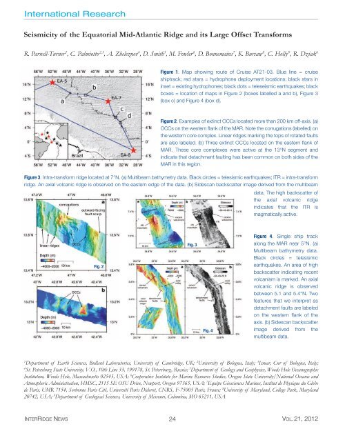
Seismicity of the Equatorial Mid-Atlantic Ridge and its Large Offset Transforms<br />
R. Parnell-Turner 1 , C. Palmiotto 2,3 , A. Zheleznov 4 , D. Smith 5 , M. Fowler 6 , D. Bonnemains 7 , K. Bursaw 8 , C. Holly 9 , R. Dziak 6<br />
Figure 1. Map showing route of Cruise AT21-03. Blue line = cruise<br />
shiptrack; red stars = hydrophone deployment locations; black stars in<br />
inset = existing hydrophones; black dots = teleseismic earthquakes; black<br />
boxes = location of maps in Figure 2 (boxes labelled a and b), Figure 3<br />
(box c) and Figure 4 (box d).<br />
Figure 2. Examples of extinct OCCs located more than 200 km off-axis. (a)<br />
OCCs on the western flank of the MAR. Note the corrugations (labelled) on<br />
the western core complex. Linear ridges marking the tops of rotated faults<br />
are also labeled. (b) Three extinct OCCs located on the eastern flank of<br />
MAR. These core complexes were active at the 13°N segment and<br />
indicate that detachment faulting has been common on both sides of the<br />
MAR in this region.<br />
Figure 3. Intra-transform ridge located at 7°N. (a) Multibeam bathymetry data. Black circles = telesismic earthquakes; ITR = intra-transform<br />
ridge. An axial volcanic ridge is observed on the eastern edge of the data. (b) Sidescan backscatter image derived from the multibeam<br />
data. The high backscatter of<br />
the axial volcanic ridge<br />
indicates that the ITR is<br />
magmatically active.<br />
Fig. 2<br />
Fig. 3<br />
Fig. 4<br />
Figure 4. Single ship track<br />
along the MAR near 5°N. (a)<br />
Multibeam bathymetry data.<br />
Black circles = telesismic<br />
earthquakes. An area of high<br />
backscatter indicating recent<br />
volcanism is marked. An axial<br />
volcanic ridge is observed<br />
between 5.1 and 5.4°N. Two<br />
features that we interpret as<br />
detachment faults are labeled<br />
on the western flank of the<br />
axis. (b) Sidescan backscatter<br />
image derived from the<br />
multibeam data.<br />
1<br />
Department of Earth Sciences, Bullard Laboratories, University of Cambridge, UK; 2 University of Bologna, Italy; 3 Ismar, Cnr of Bologna, Italy;<br />
4<br />
St. Petersburg State University, V.O., 10th Line 33, 199178, St. Petersburg, Russia; 5 Department of Geology and Geophysics, Woods Hole Oceanographic<br />
Institution, Woods Hole, Massachusetts 02543, USA; 6 Cooperative Institute for Marine Resource Studies, Oregon State University/National Oceanic and<br />
Atmospheric Administration, HMSC, 2115 SE OSU Drive, Newport, Oregon 97365, USA; 7 Equipe Géosciences Marines, Institut de Physique du Globe<br />
de Paris, UMR 7154, Sorbonne Paris Cité, Université Paris Diderot, CNRS, F-75005 Paris, France; 8 University of Maryland, College Park, Maryland<br />
20742, USA; 9 Department of Geological Sciences, University of Missouri, Columbia, MO 65211, USA<br />
INTERRIDGE NEWS 24 VOL.21, 2012