Mulranny Walking Experience 2013 - Mulranny Mayo Ireland
Mulranny Walking Experience 2013 - Mulranny Mayo Ireland
Mulranny Walking Experience 2013 - Mulranny Mayo Ireland

Create successful ePaper yourself
Turn your PDF publications into a flip-book with our unique Google optimized e-Paper software.
500<br />
400<br />
100<br />
100<br />
200<br />
300<br />
400<br />
500<br />
600<br />
600<br />
500<br />
500<br />
600<br />
200<br />
100<br />
500<br />
300<br />
200<br />
100<br />
400<br />
100<br />
600<br />
300 200<br />
600<br />
500<br />
400<br />
100<br />
600<br />
500<br />
400<br />
100<br />
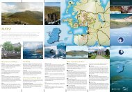
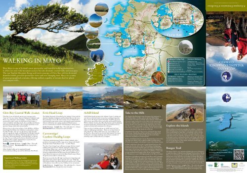
WALKING IN MAYO<br />
West <strong>Mayo</strong> is one of <strong>Ireland</strong>’s most spectacular and beautiful walking destinations.<br />
It offers not only wild mountain scenery but also dramatic coastal walks and seascapes.<br />
The vast Nephin Mountain Range and iconic seascape of Clew Bay, with its drowned<br />
drumlin islands, provide spectacular views and ever changing hues. <strong>Mayo</strong> is a county<br />
of great geographical contrasts, offering walkers a quality of terrain that few places<br />
can compete with…<br />
<strong>Mulranny</strong><br />
MAYO<br />
Cork<br />
Achill Head<br />
Belfast<br />
Sligo<br />
Knock<br />
IRELAND<br />
Galway<br />
Shannon<br />
Dublin<br />
Rosslare Harbour<br />
Inishkea<br />
688<br />
Croaghaun<br />
Lough<br />
Acorrymore<br />
R319<br />
Inishturk<br />
Inishbofin<br />
R313<br />
Blacksod Bay<br />
Slievemore<br />
672<br />
Achill Island<br />
Keel<br />
Keel<br />
Lough<br />
Cleggan<br />
Bunacurry<br />
466<br />
6<br />
Erris Head<br />
6<br />
Achillbeg<br />
Island<br />
Clare Island<br />
Clifden<br />
Belmullet<br />
Kildownet<br />
Castle<br />
300<br />
400<br />
500<br />
700<br />
600<br />
KILLARY HARBOUR<br />
Lough Fee<br />
Kylemore Lough<br />
Great Western Greenway<br />
1 452<br />
Knockletragh<br />
N59<br />
R313<br />
INISHBIGGLE<br />
ANNAGH<br />
ISLAND<br />
ACHILL<br />
SOUND<br />
R319<br />
524<br />
Corraun Hill<br />
500<br />
400<br />
300<br />
200<br />
N59<br />
The Twelve Pins<br />
654 725<br />
100<br />
Louisburgh<br />
Carrowteige 156<br />
688 Lough<br />
Acorrymore<br />
Croaghaun<br />
R314<br />
R319<br />
Carrowmore<br />
Lake<br />
364<br />
R335<br />
2<br />
Doo Lough<br />
100<br />
Bangor Trail<br />
5<br />
Maumykelly<br />
Slieve Carr<br />
721<br />
300<br />
200<br />
627<br />
Visitor Centre Nephin Beg<br />
311<br />
N A T I O N A L<br />
P A R K Glennamong<br />
628<br />
3<br />
Claggan Mountain<br />
714<br />
R336<br />
Maumturk Mountains<br />
6<br />
Western Way<br />
762<br />
Sheeffry Hills<br />
803<br />
Ben Creggan<br />
Mweelrea Mountains<br />
700<br />
Ben Gorm<br />
100<br />
200<br />
300<br />
200<br />
Achill Head<br />
700<br />
Bangor<br />
Ballycroy<br />
300<br />
400<br />
667<br />
100<br />
200<br />
300<br />
400<br />
200<br />
300<br />
400<br />
500<br />
<strong>Mulranny</strong><br />
European Destination of Excellence<br />
Clew Bay<br />
600<br />
N E<br />
Croagh Patrick<br />
764<br />
500<br />
400<br />
Blacksod Bay<br />
Achill Island<br />
P H I N<br />
St Brendens<br />
Well<br />
Leenaun<br />
Rockfleet<br />
Castle<br />
Lough<br />
Feeagh<br />
Slievemore<br />
672Ballycastle<br />
B E G<br />
4<br />
Burrishoole<br />
Abbey<br />
Bellacorick<br />
Western Way<br />
Bunaveela<br />
Lough<br />
Western Way / Bangor Trail<br />
Great Western Greenway<br />
Beltra<br />
Lough<br />
Clare R317 Island<br />
Furnace<br />
Lough<br />
N59<br />
1<br />
R335<br />
N59<br />
R A N<br />
R312<br />
588<br />
Buckoogh<br />
Church<br />
Inishturk<br />
Inishbofin<br />
R330<br />
Western Way<br />
Maumtrasna<br />
673<br />
300<br />
200<br />
Keel<br />
Keel<br />
Lough<br />
G E<br />
Lough Nafooey<br />
Cleggan<br />
N59<br />
698<br />
Birreencorragh<br />
Newport<br />
Bunacurry<br />
466<br />
R311<br />
Westport<br />
R312<br />
6<br />
R315<br />
Nephin<br />
806<br />
700<br />
600<br />
500<br />
400<br />
300<br />
200<br />
100<br />
R315<br />
N5<br />
Lough<br />
Mask<br />
Lough<br />
Mask<br />
R314<br />
Crossmolina 524<br />
6<br />
Ballina<br />
Corraun Hill<br />
Achillbeg<br />
Island<br />
Clifden<br />
Castlebar<br />
INISHBIGGLE<br />
ANNAGH<br />
ISLAND<br />
Kildownet<br />
Castle<br />
N84<br />
ACHILL<br />
SOUND<br />
N84<br />
Lough<br />
Conn<br />
Pontoon<br />
R310<br />
Ballinrobe<br />
R334<br />
R319<br />
N60<br />
300<br />
400<br />
500<br />
700<br />
600<br />
Lough<br />
Cullin<br />
N26<br />
River Moy<br />
KILLARY HARBOUR<br />
Lough Fee<br />
Great Western Greenway<br />
1 452<br />
Knockletragh<br />
400<br />
300<br />
200<br />
100<br />
N58<br />
R335<br />
Foxford<br />
100<br />
Easy/Moderate Length: 42km<br />
N59<br />
R336<br />
Kylemore Lough<br />
Achill to <strong>Mulranny</strong> Maumturk (13km) Mountains<br />
100<br />
100<br />
Cycling Time: 1 to 1.5 Hours<br />
200<br />
200<br />
300<br />
300<br />
The Twelve CongPins<br />
<strong>Walking</strong> Time: 2 to 500 400<br />
600 2.5 Hours<br />
400<br />
500<br />
667<br />
600<br />
654 725<br />
2<br />
N5<br />
Doo Lough<br />
N26<br />
100<br />
5<br />
il<br />
100<br />
200<br />
500<br />
400<br />
300<br />
Nephin Beg<br />
N A T I O N A L<br />
P A R K Glennamong<br />
Claggan Mountain<br />
762<br />
714<br />
6<br />
Croagh Patrick<br />
Western Way<br />
311<br />
Lough<br />
Feeagh<br />
4<br />
Bunaveela<br />
Lough<br />
3<br />
Western Way / Bangor Trail<br />
Furnace<br />
Lough<br />
N59<br />
Great Western Greenway<br />
1<br />
R335<br />
N59<br />
Lough Nafooey<br />
Buckoogh<br />
R330<br />
Birreencorragh<br />
Western Way<br />
R317<br />
Great Western Greenway To <strong>Mulranny</strong> from<br />
Sheeffry Hills Knock Airport: 1 hour 28 min<br />
<strong>Mulranny</strong> Loop<br />
803<br />
Galway: 90 min Westport: 25 min<br />
Letterkeen Loop Ben Creggan Castlebar: 30 min<br />
Mweelrea Mountains<br />
Lettermaghera Loop 700<br />
By Air Maumtrasna<br />
Ben Gorm <strong>Ireland</strong> West 673 Airport Knock<br />
Clew Bay Coastal Walk<br />
By Rail<br />
600<br />
Achill Cycle Hub & Achill Spur Train to Westport<br />
500<br />
or Castlebar<br />
100<br />
500<br />
200<br />
400<br />
300<br />
200<br />
500<br />
Louisburgh<br />
700<br />
Ballycroy<br />
Visitor Centre<br />
600<br />
500<br />
400<br />
300<br />
200<br />
100<br />
200<br />
500<br />
300<br />
400<br />
<strong>Mulranny</strong><br />
100<br />
500<br />
400<br />
600<br />
N E<br />
500<br />
400<br />
300<br />
200<br />
300<br />
600<br />
200<br />
764<br />
100<br />
628<br />
European Destination of Excellence<br />
Clew Bay<br />
<strong>Walking</strong> & Cycling Trails<br />
P H I N<br />
St Brendens<br />
Well<br />
Leenaun<br />
627<br />
Rockfleet<br />
Castle<br />
B E G<br />
Burrishoole<br />
Abbey<br />
400<br />
R A N<br />
Church<br />
300<br />
200<br />
588<br />
100<br />
G E<br />
698<br />
Newport<br />
Getting to <strong>Mulranny</strong><br />
GREAT WESTERN GREENWAY<br />
Beltra<br />
Lough<br />
R311<br />
Westport<br />
<strong>Mulranny</strong> to Newport (18km)<br />
Cycling Time: 2 to 2.5 Hours<br />
<strong>Walking</strong> Time: 5 to 5.5 Hours<br />
Newport to Westport (11km)<br />
Cycling Time: 1 to 1.5 Hours<br />
<strong>Walking</strong> Time: 3 to 3.5 Hours<br />
R312<br />
Nephin<br />
700<br />
600<br />
500<br />
400<br />
300<br />
200<br />
100<br />
806<br />
R315<br />
Castlebar<br />
N5<br />
Lough<br />
Mask<br />
Lough<br />
Mask<br />
N84<br />
N84<br />
Lough<br />
Conn<br />
Pontoon<br />
R310<br />
Ballinrobe<br />
R334<br />
Cong<br />
N60<br />
Lough<br />
Cullin<br />
N26<br />
A MULRANNY TOURISM INITIATIVE<br />
A European Destination of Excellence<br />
A Collection of Stunning<br />
Walks Suitable For All<br />
N58<br />
Foxford<br />
MULRANNY<br />
WALKING EXPERIENCE<br />
CO MAYO<br />
N5<br />
N26<br />
Clew Bay Coastal Walk (Guided)<br />
Erris Head Loop<br />
Erris Loop<br />
Achill Island<br />
Achill Island<br />
Take to the Hills<br />
Clew Bay is one of <strong>Ireland</strong>’s most iconic seascapes and a<br />
“must see” for any visitor. Discover <strong>Mulranny</strong>’s Machair sand<br />
dunes, one of Europe’s rarest habitats – dynamic landforms<br />
renowned for their variety of wild flowers, they feature a<br />
variety of habitats including beach, dune, mudflat and Atlantic<br />
salt marsh. Rosmurrevagh is a fine example and home to rare<br />
species of fungi, moths and curious beetles.<br />
Historic sites on the route include a Celtic Midden, a Killeen,<br />
Gairí Beagh Na bPáistí, (the Children’s small garden), a fairy<br />
fort Blea Na Shee, (the curve of the fairies) a fine lime kiln<br />
and the magnificent single arch Washing Pool Bridge. Rosturk<br />
takes you deeper into the bay offering exceptional views of<br />
Clew Bay’s drowned drumlins, a beautiful legacy of the last<br />
Ice Age. You can walk past the historic Rosturk Castle and<br />
the guides offer a unique opportunity to access the once<br />
inhabited island of Moynish Mór.<br />
Route 5 Grade: Moderate Length: 19km – The walk<br />
takes 5 – 5½ hours Recommended: Boots, waterproofs,<br />
water & snacks.<br />
Other Guided walks can be organised through<br />
www.mulrannywalking.com and the <strong>Mulranny</strong> Park Hotel.<br />
<strong>Experience</strong>d <strong>Walking</strong> Guides<br />
There are a number of very knowledgeable experienced<br />
walking guides in <strong>Mayo</strong>. Using a walking guide on any<br />
walk will change the way you look at the living landscape.<br />
Find more information on walking guides at<br />
www.mulranny.ie<br />
The Mullet Peninsula is bounded by the Atlantic Ocean and the<br />
islands of Inishkea, Inishglora and Duvillaun More to the west.<br />
The peninsula is one of the most remote areas of <strong>Ireland</strong> and is<br />
characterised by spectacular scenery and unspoilt natural amenities.<br />
Visitors will find an easy-going, traditional lifestyle intact.<br />
Erris is a Gaeltacht area and the Irish language is still practiced.<br />
Grade: Moderate Length: 5km – The walk takes 1½ – 2 hours<br />
Recommended: Boots, waterproofs, water & snacks.<br />
Carrowteige/<br />
Ceathrú Thaidhg Loops<br />
“The finest sustained coastal walk in western <strong>Ireland</strong>, with a<br />
profusion of precipitous cliffs, crags, caves, chasms and islands<br />
along the remote North <strong>Mayo</strong> coast.” – Lonely Planet.<br />
The three Carrowteige loop walks are amongst the best coastal<br />
walking trails anywhere in <strong>Ireland</strong>. Taking the walker from<br />
Carrowteige village onto a section of the dramatic North <strong>Mayo</strong><br />
coast that includes breathtaking sea cliffs and lovely sandy beaches.<br />
From the trailhead follow the blue arrows for the Children of Lir<br />
loop (10km), the red arrows are for the Black Ditch Loop, (13km),<br />
the green arrows follow a shorter loop.<br />
Please be aware that the cliff edge is unfenced, so keep dogs and<br />
kids under strict control. Don’t miss the view over Tráigh Na<br />
bhFothantaí Dubha from Black Ditch path and the view of Stags<br />
of Broadhaven from cliffs near the Children of Lir monument.<br />
Grade: Moderate Length: Varies – The walk takes 2½ – 3 hours<br />
Recommended: Boots, waterproofs, water & snacks.<br />
Achill Island stands strong in the Atlantic Ocean. Looking out<br />
over the sea with the breeze in your face, nothing invigorates<br />
like a visit to the largest island off <strong>Ireland</strong>. Achill has glorious<br />
cliff scenery, spectacular drives and walks and beautiful beaches.<br />
With its Atlantic location, five Blue Flag beaches and breathtaking<br />
mountain landscapes, Achill provides an unrivalled arena for<br />
outdoor activities and watersports for all types.<br />
There are lots of walking options on Achill from easy loop<br />
walks to challenging mountains... There are no fewer than 13<br />
self guided loop walks graded from easy and suitable for all<br />
the family to those that are not for the faint hearted! For those<br />
looking for a mountain challenge choose from a number of<br />
stunning routes on Slievemore or Croaghan.<br />
Carrowteige Loop<br />
The Nephin Beg Mountain range dominates the landscape in<br />
North West <strong>Mayo</strong>. It offers some of the best Hillwalking<br />
opportunities anywhere in <strong>Ireland</strong>. This relatively undiscovered<br />
mountain range contains five iconic hikes for the experienced<br />
hillwalker. Nephin itself is a towering mountain of some 806<br />
metres and the views from the top are impressive. On a clear<br />
day Slieve League in Donegal is visible. Nearby Bireencorragh<br />
Horseshoe is a tough but very rewarding circuit. It rises to 698<br />
metres with a Bronze Age burial site at the top.<br />
Glendahork Horseshoe (714m) is one of <strong>Ireland</strong>’s finest high<br />
level circuits. Nephin Beg (627m) and Slieve Carr (541m) are<br />
more remote but well worth the hike into the north <strong>Mayo</strong><br />
wilderness and Ballycroy National Park.<br />
Nearby Achill Island & the Corraun Peninsula have some of the<br />
best high level hikes with Croaghaun (688m) and Slievemore<br />
(672m) as two examples with dramatic views of the Atlantic Ocean.<br />
Further south there’s the iconic Croagh Patrick that rises 764<br />
metres into the sky above <strong>Mayo</strong>. The tradition of pilgrimage<br />
to this holy mountain stretches back over 5,000 years from the<br />
Stone Age to the present day without interruption. Magnificent<br />
views of Clew Bay and the surrounding south <strong>Mayo</strong> countryside<br />
are spectacular from all stages of the ascent of the mountain.<br />
At 750 metres it is one of the highest peaks in the West of <strong>Ireland</strong>.<br />
Mweelrea is the highest mountain in both <strong>Mayo</strong> and Connaught.<br />
Standing at 814 meters the peak offers panoramic and dramatic<br />
views of surrounding mountains such as the Sheeffry Hills, the<br />
Twelve Pins, Croagh Patrick with the backdrop of the Atlantic<br />
Ocean, Killary Harbour and some of <strong>Mayo</strong>’s finest beaches. With<br />
all these wonders on offer you’ll not be surprised to learn that these<br />
vistas are not given lightly but are earned. Not for the faint hearted!<br />
As with all hikes they require a guide and demand good levels of<br />
fitness, experience, water, food and appropriate hiking gear.<br />
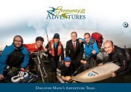
Explore the Islands<br />
<strong>Mayo</strong>’s offshore islands are a paradise for walkers - windswept<br />
hills of blanket bog, towering cliffs and pristine sandy shores.<br />
These small dollops of land offer a remarkable variety of trails<br />
from short looped walks and strolls to lengthy hikes that will<br />
really blast away the cobwebs. Along the way, you’ll be treated<br />
to dramatic scenery, undisturbed nature and a huge collection of<br />
fascinating historical treasures. Drive onto Achill Island or hop<br />
on a ferry and discover Clare Island, Inishturk, Inishbiggle or<br />
the beautiful Inishkea Islands.<br />
Bangor Trail<br />
The Bangor Trail is a way marked trail linking the town of Newport<br />
in mid west <strong>Mayo</strong> with the town of Bangor Erris in Erris, North<br />
<strong>Mayo</strong>. It is a fascinating and wonderful trail, full of history and<br />
dating from a time when the vast swathes of North-West <strong>Mayo</strong><br />
were not yet reached by road. It meanders through the Nephin<br />
Beg mountains and makes for a great day’s walking. Not always<br />
the smoothest or driest terrain but you will enjoy great views across<br />
the bogs, mountains, coastline and plantation forests of north <strong>Mayo</strong>.<br />
Grade: Moderate to hard Length: 29km – The walk takes approx<br />
8 hours Recommended: Boots, waterproofs, water, snacks,<br />
map, compass, fully charged mobile phone & emergency bag.<br />
<strong>Mulranny</strong><br />
MAYO<br />
IRELAND<br />
A <strong>Mulranny</strong> Tourism initiative<br />
For further information please contact<br />
www.mulranny.ie<br />
www.mulrannyparkhotel.ie<br />
www.greenway.ie<br />
www.discoverireland.ie<br />
Funded by South West <strong>Mayo</strong> Development Company under the Rural Development Programme 2007 – <strong>2013</strong>,<br />
Irish Government National Development Plan 2007 – <strong>2013</strong><br />
Maoinithe ag Comhlacht Forbartha Iar-dheisceart Mhaigh Eo faoin gClár Forbartha Tuaithe 2007 – <strong>2013</strong>,<br />
Rialtas na h-Éireann Plean Forbartha Náisiúnta 2007 – <strong>2013</strong>
WALKING FROM<br />
MULRANNY CO MAYO<br />
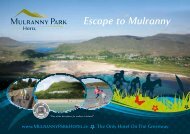
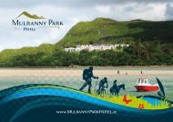
The beautiful seaside village of <strong>Mulranny</strong> is a walkers haven.<br />
Located 25 minutes from Westport and 15 minutes from both<br />
Achill Island and Ballycroy National Park,<br />
it is the ideal base for walking in <strong>Mayo</strong>.<br />
<strong>Mulranny</strong> & the Great Western Greenway have been designated a<br />
European Destination of Excellence. The award recognises the outstanding locally<br />
driven achievements, including the opening of the great Western Greenway, the<br />
sensitive restoration of the stunning <strong>Mulranny</strong> Park Hotel and the regeneration of<br />
<strong>Mulranny</strong>’s Victorian Causeway and Look Out Hill walks. Combined with a truly<br />
spectacular location these developments enhance an already remarkable place.<br />
CYCLING<br />
Within <strong>Mayo</strong>, there is a feast of great cycling options through<br />
a series of scenic routes. There are country roads leading to<br />
seaside coves and to mountain tops. The variety of scenery is<br />
almost endless: Islands, lowlands with rural villages and towns,<br />
castles, historic sites and parks to visit; highlands with fantastic<br />
scenery; and the stunning Atlantic coastline. Rich in breathtaking<br />
scenery, the area has been referred to as the cyclist’s paradise.<br />
The choices of terrain on offer range from hill-climbs to flatland<br />
so a trip may be planned which will tax the seasoned cyclist’s<br />
ability or alternatively will make for a holiday of gentle exercise.<br />
So why not hire a bike or bring your own and explore many of<br />
the <strong>Mayo</strong> Greenways, Cycle ways and Cycle hubs.<br />
Within <strong>Mayo</strong>, there is a feast of great cycling options through<br />
a series of scenic routes. There are country roads leading to<br />
seaside coves and to mountain tops. The variety of scenery is<br />
almost endless: Islands, lowlands with rural villages and towns,<br />
castles, historic sites and parks to visit; highlands with fantastic<br />
scenery; and the stunning Atlantic coastline. Rich in breathtaking<br />
scenery, the area has been referred to as the cyclist’s paradise.<br />
Route 6<br />
This walking brochure gives a taster for<br />
the walks available in Co <strong>Mayo</strong>. We are<br />
surrounded by some of the best walks in<br />
<strong>Ireland</strong> including the Burrishoole Loop<br />
series of walks which is one of the most<br />
comprehensive networks of Fáilte <strong>Ireland</strong><br />
approved walks anywhere in the country.<br />
It’s just waiting for you to explore…<br />
All walking networks depend upon the<br />
goodwill of a variety of local stakeholders<br />
including landowners, local businesses<br />
and communities. Please respect the<br />
property, the rights and the needs of each<br />
of these groups especially as most of these<br />
walks depend upon permissive access<br />
from landowners. Close gates behind you,<br />
take your litter with you and don’t bring<br />
your dog as you may travel on working<br />
farmland.<br />
ECOTOURISM<br />
“I visited <strong>Mulranny</strong> as part of a tour around all the EDEN<br />
award-winning destinations in <strong>Ireland</strong>… These are small regions<br />
which have been awarded the EU’s European Destination of<br />
Excellence Award for sustainable tourism practices.<br />
Great Western Greenway<br />
<strong>Mulranny</strong> & the Great Western Greenway is a designated<br />
European Destination of Excellence. They are a jewel in the<br />
county of <strong>Mayo</strong>.<br />
The Great Western Greenway follows the old railway line<br />
from Westport to Achill Island. On opening in 1895 it was<br />
known as one of the most scenic railways journeys in<br />
western Europe. The railway line operated until 1937.<br />
Today the line with its many fine engineering structures<br />
and breathtaking scenery has been given a new lease of life<br />
and is a fitting reminder of the glorious railway era.<br />
The Greenway is the first of its kind in <strong>Ireland</strong> and is the<br />
longest off road walk and cycle trail in the country.<br />
Route 1 Grade: Easy Length: 42km – The walk takes<br />
10-11½ hours Recommended: Boots, waterproofs, walking<br />
stick, binoculars, water & snacks.<br />
<strong>Mulranny</strong> Loop - Lookout Hill<br />
Based in the village of <strong>Mulranny</strong> this is a walk of stunning beauty<br />
and immense diversity. Such is the biodiversity here that you<br />
enter three different European designated areas of conservation<br />
and <strong>Ireland</strong>’s largest National Park. On the way visit <strong>Ireland</strong>’s<br />
only stand of Mediterranean heather, woodland, beaches, rare<br />
Machair dunes, Atlantic salt marsh and traverse Trawoughter<br />
Bay along <strong>Mulranny</strong>’s unique causeway. The route features<br />
elevated views of the dramatic deep sided Bellacragher Bay and<br />
to the south the stunning spectacle of Clew Bay and its drowned<br />
drumlin islands set against the majestic Croagh Patrick.<br />
Route 2 Grade: Moderate Length: 5½km – The walk<br />
takes 2½ hours Recommended: Boots, waterproofs, walking<br />
stick, binoculars, water & snacks.<br />
Letterkeen Loop<br />
The Letterkeen Loop takes in a hidden area of outstanding<br />
natural beauty, rugged landscape and coniferous forest. Set in<br />
the remote out-back of the Nephin Mountains, unspoilt bog<br />
and mountain stretches as far as the eye can see. This way marked<br />
walk is made up of mountain track, a somewhat challenging<br />
scramble across deforested bog land and mountainous terrain.<br />
Hike here and you’ll see that bogs can be beautiful. On a sunny<br />
day in July, the views take on an almost hallucinogenic hue: the<br />
peat bogs burn shocking pink and acid green. The route circles<br />
back to the bothy via a stretch of the Western Way, following<br />
another rugged riverside.<br />
Route 3 Grade: Hard Length: 10km – The walk takes 4 hours<br />
Recommended: Boots, waterproofs, water and snacks.<br />
Lettermaghera Loop<br />
This walk starts at the Deradda Community Centre and takes a<br />
meandering route through Burrishoole’s “lake district” with the<br />
Nephin Beg range as a stunning backdrop. Along the route you<br />
can visit the famous “Salmon Leap” at Lough Furnace, part of<br />
Europe’s oldest salmon research centre. Here you can enjoy<br />
the beautiful sight of different kinds of fish swimming in the<br />
water. You then join a bog road crossing the lower slopes of the<br />
Bengorm Mountains, which offers splendid views across Clew<br />
Bay and its islands. The route turns south again passing through<br />
Burrishoole’s “lake district” and crossing the new Great Western<br />
Greenway until you are back at the Community Centre.<br />
Route 4 Grade: Easy Length: 7km – The walk takes 2½ hours<br />
Recommended: Boots, waterproofs, water & snacks.<br />
A long time ago, the railway brought this community together<br />
and now the Greenway plays that role linking cyclists with<br />
canoeists, walkers with wildlife photographers and sailors with<br />
surfers. Although it is the extraordinary achievement of the Great<br />
Western Greenway that most people are hearing about, what<br />
they don’t discover until they get here is the whole web of<br />
wonders which weave out from the Greenway. Electric bike<br />
tours along the Bangor Trail, catamaran sailing on Bellacragher<br />
Bay, a plethora of loop walks straight out of the <strong>Mulranny</strong><br />
Park Hotel and then Achill Island at the end of it which, when<br />
you cycle around it, is like saving the icing on the cake until last.<br />
Having met a lot of the tourism providers who have come together<br />
in vital networks to make this web accessible and attractive,<br />
I was bowled over by the community-driven commitment<br />
to sustainable tourism in <strong>Mulranny</strong>, and consequently would<br />
happily cite it as a top model of ethical and sustainable tourism”<br />
– Catherine Mack<br />
Travel writer specialising in responsible and ecotourism<br />
The Local Environment<br />
Clew Bay is one of the most spectacular seascapes in Europe.<br />
The descent of its drumlins into the Atlantic Ocean is marked,<br />
first by an array of peninsulas and then an archipelago of<br />
drowned drumlin islands and inlets stretching out into the<br />
bay. This delicate ice sculpted landscape is a haven for otters<br />
and seals, seabirds and wild flowers, a panoramic vista of<br />
unparalleled beauty.<br />
<strong>Mulranny</strong> commands a superb view over the bay and its<br />
Machair sand dunes, which provide a safe idyllic platform to<br />
explore the terrestrial and inter-tidal reaches of the bay.<br />
The dunes are one of Europe’s rarest and most bio-diverse<br />
habitats and a unique attraction of Co <strong>Mayo</strong>.<br />
A multi media presentation is available in the <strong>Mulranny</strong><br />
Tourist Office which gives an insight into the local<br />
environment and our fascinating history.<br />
Last Stronghold of the Old Irish Goat<br />
<strong>Mulranny</strong>’s Old Irish Goats are colourful characters. The<br />
males in particular are impressive animals, a veritable melting<br />
pot of all things masculine – long hair, quiffs, beards and sideburns,<br />
not to mention their impressive horns. The females<br />
have a more delicate frame and a matriarchal role, their lineage<br />
is the social thread of the herd. Collectively these attributes make<br />
them a fascinating part of our natural heritage. <strong>Mayo</strong> is now<br />
the last stronghold of the Old Irish Goat, and although elusive,<br />
they are still regularly seen on the foothills around <strong>Mulranny</strong>.<br />
This is an Outdoor Ethics Programme designed to promote<br />
and inspire responsible outdoor recreation through education,<br />
research and partnerships.<br />
The Seven Principles of Leave no Trace are:<br />
• Plan ahead and prepare<br />
• Be considerate of others<br />
• Respect farm animals and wildlife<br />
• Travel on durable ground<br />
• Leave what you find<br />
• Dispose of waste properly<br />
• Minimise the effects of fire<br />
Practice a Leave no Trace ethic and make it hard for others<br />
to see or hear you.