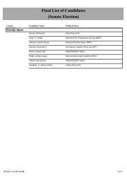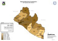
View map - National Elections Commission
View map - National Elections Commission
View map - National Elections Commission

You also want an ePaper? Increase the reach of your titles
YUMPU automatically turns print PDFs into web optimized ePapers that Google loves.
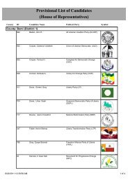
Legend<br />
" Voter Registration Center<br />
County Boundary<br />
Electoral District Boundary<br />
Administrative District Boundary<br />
Amalgamated Area Boundary<br />
NOTE: Administrative unit boundaries shown here do<br />
not represent official endorsement by the <strong>National</strong><br />
<strong>Elections</strong> <strong>Commission</strong> or the Government of Liberia.<br />
The process for the accurate demarcation and<br />
<strong>map</strong>ping of administrative units is currently on-going.<br />
Upon completion of this process, the Government of<br />
Liberia shall release the official boundaries for<br />
administrative units of Liberia<br />
Sierra Leone<br />
"<br />
"<br />
21046<br />
Konkpama<br />
21070<br />
Ndehuma<br />
"<br />
Guinea<br />
21047<br />
Sinagole<br />
21083<br />
"<br />
21069<br />
"<br />
Foya<br />
21027<br />
"<br />
21025<br />
"<br />
"<br />
Yelayaloe<br />
21026 "<br />
21028<br />
Foya<br />
"<br />
21115<br />
"<br />
"<br />
Fassapoe21021<br />
"<br />
21020<br />
"<br />
Lepaloe<br />
21012<br />
Borliloe<br />
21066<br />
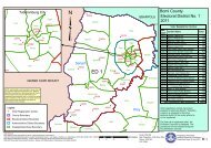
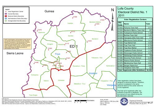
ED 1<br />
Savalahun - Three<br />
"<br />
21004<br />
Bandenin Melimu<br />
21005<br />
"<br />
Bandenin<br />
21003<br />
Fassavolu - Two<br />
Kolahun<br />
"<br />
³<br />
Lofa County<br />
Electoral District No. 1<br />
2011<br />
VRC<br />
Code<br />
Voter Registration Centers<br />
Name Total<br />
21003 Porluma Town Hall 2,511<br />
21004 Bandenin Melimu Town Hall 897<br />
21005 Forbayman Public School 1,169<br />
21012 Borliloe Town Hall 1,051<br />
21020 Fassapoe (Old) Town Hall 573<br />
21021 Mbenduma Public School 1,412<br />
21025 Foya Market Hall 3,000<br />
21026 Foya Town Hall 2,759<br />
21027 Foya New Market 2,256<br />
21028 Foyakama Public School 1,726<br />
21046 Worsongar Public School 2,907<br />
21047 Wahbengu Public School 789<br />
21066 Solumba Public School 2,090<br />
21069 Ndama Public School 1,922<br />
21070 Mendicorma Town Hall 2,821<br />
Kambolahun - One21083 Sengar Palava Hut 1,661<br />
21115 Yelayaloe Town Hall 824<br />
Total Registrants (After Exhibition):<br />
30,368<br />
Ndama<br />
Kimbaloe<br />
Mbabahun - Four<br />
Fangalahun - Five<br />
Voinjama<br />
Voter registration centers have been<br />
assigned to electoral districts. Therefore,<br />
a person is assigned to the same<br />
electoral district of the center where he<br />
or she registered.<br />
Foya Tengia<br />
The final roll of registrants (after the<br />
Exhibition Exercise) is displayed. The<br />
provisional roll was utilized during the<br />
the delineation exercise.<br />
Data Sources:<br />
2011 <strong>National</strong> Voter Registration Exercise- <strong>National</strong> <strong>Elections</strong> <strong>Commission</strong>s<br />
2009-2010 Administrative Boundary & Locality Revalidation Project - Inter-Agency Taskforce on Delimitation (IATD: MIA, MLME, NEC, LISGIS)<br />
2007 <strong>National</strong> Geographic Planning - LIberia Institute of Statistics & Geo-Information Services (LISGIS)<br />
2006-2007 Boundary Harmonization Exercise - Special Joint Stakeholders Collaborative Committee (SJSCC)<br />
Kilometers<br />
0 1 2 4<br />
Scale: 80,000<br />
Map Projection: UTM Zone 29N<br />
Datum: WGS 84<br />
Unit: Meter<br />
Prepared & Printed By:<br />
<strong>National</strong> <strong>Elections</strong> <strong>Commission</strong><br />
Production Date: 29 July 2011<br />
M 27
Legend<br />
" Voter Registration Center<br />
"<br />
County Boundary<br />
Electoral District Boundary<br />
Administrative District Boundary<br />
Amalgamated Area Boundary<br />
NOTE: Administrative unit boundaries shown here do<br />
not represent official endorsement by the <strong>National</strong><br />
<strong>Elections</strong> <strong>Commission</strong> or the Government of Liberia.<br />
The process for the accurate demarcation and<br />
<strong>map</strong>ping of administrative units is currently on-going.<br />
Upon completion of this process, the Government of<br />
Liberia shall release the official boundaries for<br />
administrative units of Liberia<br />
21049<br />
"<br />
21048<br />
"<br />
Kortuma<br />
21098<br />
21099<br />
Vahun<br />
"<br />
21100<br />
"<br />
"<br />
21097<br />
"<br />
Vahun<br />
21096<br />
Upper Guma<br />
GBARPOLU<br />
Sierra Leone<br />
Kamatahun- Two<br />
Data Sources:<br />
2011 <strong>National</strong> Voter Registration Exercise- <strong>National</strong> <strong>Elections</strong> <strong>Commission</strong>s<br />
2009-2010 Administrative Boundary & Locality Revalidation Project - Inter-Agency Taskforce on Delimitation (IATD: MIA, MLME, NEC, LISGIS)<br />
2007 <strong>National</strong> Geographic Planning - LIberia Institute of Statistics & Geo-Information Services (LISGIS)<br />
2006-2007 Boundary Harmonization Exercise - Special Joint Stakeholders Collaborative Committee (SJSCC)<br />
³<br />
ED 2<br />
Foya<br />
"<br />
Konkpama<br />
"<br />
21036<br />
21035<br />
21029<br />
Foya Tengia<br />
"<br />
"<br />
"<br />
21052<br />
21051<br />
Kpagamai - One<br />
Ndama<br />
Kolahun<br />
"<br />
21113<br />
"<br />
Bowahun- Two<br />
Yassadu<br />
21075<br />
Popalahun- One<br />
Foya Fassapoe<br />
21074<br />
Kilometers<br />
0 2 4 8<br />
21043<br />
"<br />
"<br />
Kimbaloe<br />
21063<br />
"<br />
"<br />
" 21065<br />
21062<br />
Lehun-Two<br />
Savalahun - Three<br />
Mbabahun - Four<br />
21064<br />
"<br />
Bowalahun- One<br />
Pasolahun - One<br />
Scale: 250,000<br />
Map Projection: UTM Zone 29N<br />
Datum: WGS 84<br />
Unit: Meter<br />
Lofa County<br />
Electoral District No. 2<br />
2011<br />
VRC<br />
Code<br />
Voter Registration Centers<br />
Name Total<br />
21029 Foya Tengia Town Hall 2,383<br />
21035 Kamatahun Public School 2,161<br />
21036 Fokolahun Public School 1,743<br />
21043 Kimbaloe Public School 1,155<br />
21048 Folima Town Hall 2,066<br />
21049 Kamalah Town Hall 1,603<br />
21051 Langbemba Town Hall 1,676<br />
21052 Kpagamai Town Hall 573<br />
21062 Porlowu Public School 868<br />
21063 Masambolahun Public School 2,055<br />
21064 Lehuma Town Hall 723<br />
21065 Fangonda Public School 784<br />
21074 Kimbalahun Town Hall 565<br />
21075 Popalahun Public School 1,839<br />
21096 Memolahun Public School 1,360<br />
21097 Seema Public School 1,371<br />
21098 Fulawahun Palava Hut 2,005<br />
21099 Jorpowahun Town Hall 1,800<br />
21100 Vahun Town Hall 2,286<br />
21113 Yassadu Public School 1,542<br />
Total Registrants (After Exhibition):<br />
Voter registration centers have been<br />
assigned to electoral districts. Therefore,<br />
a person is assigned to the same<br />
electoral district of the center where he<br />
or she registered.<br />
The final roll of registrants (after the<br />
Exhibition Exercise) is displayed. The<br />
provisional roll was utilized during the<br />
the delineation exercise.<br />
Prepared & Printed By:<br />
<strong>National</strong> <strong>Elections</strong> <strong>Commission</strong><br />
Production Date: 29 July 2011<br />
30,558<br />
M 28
Legend<br />
" Voter Registration Center<br />
Kortuma<br />
County Boundary<br />
Electoral District Boundary<br />
Administrative District Boundary<br />
Amalgamated Area Boundary<br />
NOTE: Administrative unit boundaries shown here do<br />
not represent official endorsement by the <strong>National</strong><br />
<strong>Elections</strong> <strong>Commission</strong> or the Government of Liberia.<br />
The process for the accurate demarcation and<br />
<strong>map</strong>ping of administrative units is currently on-going.<br />
Upon completion of this process, the Government of<br />
Liberia shall release the official boundaries for<br />
administrative units of Liberia<br />
Sierra Leone<br />
Vahun<br />
Vahun<br />
Upper Guma<br />
GBARPOLU<br />
Kamatahun- Two<br />
Voter registration centers have been<br />
assigned to electoral districts. Therefore,<br />
a person is assigned to the same<br />
electoral district of the center where he<br />
or she registered.<br />
The final roll of registrants (after the<br />
Exhibition Exercise) is displayed. The<br />
provisional roll was utilized during the<br />
the delineation exercise.<br />
³<br />
Konkpama<br />
21019<br />
Kimbaloe<br />
"<br />
Ndama Mbabahun - Four<br />
Fangalahun - Five<br />
Bandenin Melimu<br />
Lepaloe<br />
21095 Worbalamai<br />
" Lawalazu<br />
Ndehuma<br />
21071<br />
21094 21061<br />
Borliloe<br />
"<br />
"<br />
"<br />
Bandenin Nyandemoilahun-OneTobogizizu<br />
21060<br />
Yelayaloe<br />
Sinagole<br />
Telkpelembu-Two " 21093<br />
" " 21013<br />
21014<br />
Fassapoe<br />
Foya<br />
Savalahun - Three<br />
Bowahun- Two<br />
21079<br />
21135<br />
"<br />
"<br />
21078<br />
"<br />
21068<br />
"<br />
21067<br />
" 21084<br />
"<br />
21085<br />
21057<br />
"<br />
Bowalahun- One<br />
21015<br />
"<br />
21016<br />
"<br />
21072<br />
"<br />
21112<br />
"<br />
21111<br />
"<br />
Yaselahun - Two<br />
" 21037<br />
Foya Tengia<br />
Somalahun - Six<br />
Yassadu 21056<br />
21086<br />
"<br />
"<br />
Kpangihemba-One<br />
Kpagamai - One Lehun-Two<br />
Kolahun<br />
Foya<br />
Popalahun- One<br />
Fassavolu - Two<br />
Kambolahun - One<br />
ED 3<br />
Pasolahun - One<br />
21073<br />
"<br />
Guinea<br />
21117<br />
"<br />
"<br />
21116<br />
Zawordamai<br />
Data Sources:<br />
2011 <strong>National</strong> Voter Registration Exercise- <strong>National</strong> <strong>Elections</strong> <strong>Commission</strong>s<br />
2009-2010 Administrative Boundary & Locality Revalidation Project - Inter-Agency Taskforce on Delimitation (IATD: MIA, MLME, NEC, LISGIS)<br />
2007 <strong>National</strong> Geographic Planning - LIberia Institute of Statistics & Geo-Information Services (LISGIS)<br />
2006-2007 Boundary Harmonization Exercise - Special Joint Stakeholders Collaborative Committee (SJSCC)<br />
Voinjama<br />
Kpadehmai<br />
Vezala<br />
21054<br />
"<br />
21050<br />
"<br />
Wanleima<br />
21055<br />
"<br />
Kpakamai<br />
Karzah<br />
Kesselemai<br />
Bodah<br />
Zorzor<br />
Kilometers<br />
0 4 8 16<br />
Dayzabah<br />
Zogolemai<br />
Konia<br />
Balagwalazu<br />
Woulowumo<br />
Saygbama<br />
Voinjama<br />
City Quardu Gboni<br />
Womama<br />
Sylakorlor<br />
Barkedu<br />
Wanglodu<br />
Barziwen<br />
Zelemai<br />
Wuomai<br />
Fissibu<br />
Scale: 500,000<br />
Map Projection: UTM Zone 29N<br />
Datum: WGS 84<br />
Unit: Meter<br />
Lofa County<br />
Electoral District No. 3<br />
2011<br />
VRC<br />
Code<br />
Voter Registration Centers<br />
Name Total<br />
21013 Lukasu Town Hall 1,266<br />
21014 Bondowalahun Town Hall 781<br />
21015 Bowalahun Town Hall 983<br />
21016 Gilema Town Hall 460<br />
21019 Balahun Public School 1,194<br />
21037 Taninahun Public School 1,197<br />
21050 Kpadehmai Town Hall 1,107<br />
21054 Zeayorzu Public School 371<br />
21055 Kpakamai Public School 366<br />
21056 Bolahun Public School 1,435<br />
21057 Sosomolahun Public School 1,092<br />
21060 Lawalazu Town Hall 1,091<br />
21061 Lawalazu Public School 860<br />
21067 Mbabahun Public School 866<br />
21068 Korworhun Public School 689<br />
21071 Nyandemoilahun Public Sch. 1,107<br />
21072 Pasolahun Town Hall 453<br />
21073 Gondorlahun Public School 787<br />
21078 Savalahun Town Hall 1,011<br />
21079 Kamatahum Public School 1,003<br />
21084 Kolahun Public School 2,316<br />
21085 Kolahun Town Hall 2,453<br />
21086 Somalahun Town Hall 1,136<br />
21093 Tawalahun Town Hall 983<br />
21094 Sammie Public School 687<br />
21095 Tobogizizu Public School 1,362<br />
21111 Yaselahun Town Hall 396<br />
21112 Gelema Town Hall 594<br />
21116 Zawordamai Public School 799<br />
21117 Johny's Town Public School 359<br />
21135 Ngorkorhun Public School 1,004<br />
Total Registrants (After Exhibition):<br />
Prepared & Printed By:<br />
<strong>National</strong> <strong>Elections</strong> <strong>Commission</strong><br />
Production Date: 29 July 2011<br />
30,208<br />
M 29
³<br />
Guinea<br />
"<br />
21109<br />
Worbalamai<br />
Bandenin Melimu<br />
21081<br />
"<br />
21137 "<br />
Saygbama<br />
"<br />
Tobogizizu<br />
21138 21080<br />
"<br />
21082<br />
Bandenin Nyandemoilahun-One Lawalazu<br />
21139<br />
"<br />
" " "<br />
21134 21136<br />
" "<br />
Telkpelembu-Two<br />
21041 21131<br />
21129<br />
" 21133 "<br />
"<br />
21132<br />
21108 21107 "<br />
Kolahun<br />
Womama<br />
"<br />
Vezala<br />
Quardu Gboni<br />
21101 21040 Voinjama<br />
Kambolahun - One<br />
"<br />
21088<br />
21103<br />
Kesselemai<br />
"<br />
"<br />
City<br />
" 21102<br />
21130<br />
"<br />
21089 Wanglodu<br />
21018 Sylakorlor"<br />
"<br />
Fangalahun - Five<br />
21104<br />
Barkedu<br />
"<br />
Dayzabah 21006 " 21007<br />
Zawordamai<br />
Kpakamai<br />
21017<br />
Somalahun - Six<br />
Bowalahun- One<br />
Pasolahun - One<br />
Yaselahun - Two<br />
Kpadehmai<br />
Wanleima<br />
Voinjama<br />
Karzah<br />
"<br />
21039 21038<br />
"<br />
Bodah<br />
"<br />
ED 4<br />
"<br />
Zorzor<br />
"<br />
21121<br />
Zogolemai<br />
21122<br />
Konia<br />
"<br />
21045<br />
Balagwalazu<br />
"<br />
Barziwen<br />
21008<br />
21044<br />
Data Sources:<br />
2011 <strong>National</strong> Voter Registration Exercise- <strong>National</strong> <strong>Elections</strong> <strong>Commission</strong>s<br />
2009-2010 Administrative Boundary & Locality Revalidation Project - Inter-Agency Taskforce on Delimitation (IATD: MIA, MLME, NEC, LISGIS)<br />
2007 <strong>National</strong> Geographic Planning - LIberia Institute of Statistics & Geo-Information Services (LISGIS)<br />
2006-2007 Boundary Harmonization Exercise - Special Joint Stakeholders Collaborative Committee (SJSCC)<br />
"<br />
Zelemai<br />
Ziggida Kpassagizia<br />
Borkeza<br />
Fissibu<br />
"<br />
Warkesu<br />
Yeala<br />
Five<br />
21134<br />
Three<br />
Legend<br />
Kilometers<br />
0 2 4 8<br />
"<br />
"<br />
21131<br />
21137<br />
Seven<br />
Two<br />
Kesselemai<br />
Six<br />
"<br />
"<br />
"<br />
" Voter Registration Center<br />
County Boundary<br />
Saygbama<br />
21138<br />
21139<br />
"<br />
21136<br />
Nine<br />
21129<br />
One<br />
Eight<br />
Quardu Gboni<br />
Voinjama City<br />
"<br />
Four<br />
Electoral District Boundary<br />
Administrative District Boundary<br />
Amalgamated Area Boundary<br />
"<br />
Womama<br />
21133<br />
Womama<br />
Voter registration centers have been<br />
assigned to electoral districts. Therefore,<br />
a person is assigned to the same<br />
electoral district of the center where he<br />
or she registered.<br />
The final roll of registrants (after the<br />
Exhibition Exercise) is displayed. The<br />
provisional roll was utilized during the<br />
the delineation exercise.<br />
NOTE: Administrative unit boundaries shown here do<br />
not represent official endorsement by the <strong>National</strong><br />
<strong>Elections</strong> <strong>Commission</strong> or the Government of Liberia.<br />
The process for the accurate demarcation and<br />
<strong>map</strong>ping of administrative units is currently on-going.<br />
Upon completion of this process, the Government of<br />
Liberia shall release the official boundaries for<br />
administrative units of Liberia<br />
Scale: 450,000<br />
Map Projection: UTM Zone 29N<br />
Datum: WGS 84<br />
Unit: Meter<br />
Lofa County<br />
Electoral District No. 4<br />
2011<br />
VRC<br />
Code<br />
Voter Registration Centers<br />
Name<br />
Total<br />
21006 Barkedu Public School 1,331<br />
21007 Barkedu Town Hall 1,505<br />
21008 Barziwen Public School 1,016<br />
21017 Dayzabah Public School 384<br />
21018 David Selma-ta Public School 961<br />
21038 Karzah Public School 509<br />
21039 Wobeyammai Town Hall 307<br />
21040 Bazagizia, Public School 844<br />
21041 Betejama Public School 628<br />
21044 Konia Public School 2,500<br />
21045 Luyeama Public School 754<br />
21080 Sarkonedu Public School 1,112<br />
21081 Sarkonedu Public School 831<br />
21082 Kondadu Public School 988<br />
21088 Samodu Public School 811<br />
21089 Jarmulor Public School 483<br />
21101 Vezala Public School 958<br />
21102 Korlela Public School 672<br />
21103 Kanela Public School 630<br />
21104 Tussu Public School 725<br />
21107 Marverkonnedu Public School 365<br />
21108 Gbegbedu Public School 1,292<br />
21109 Kugbemai Public 785<br />
21121 Blakpalasu Public School 828<br />
21122 John's Town Public School 1,015<br />
21129 Karsa Gas Station 2,094<br />
21130 Tenebu Town Hall 617<br />
21131 Voinjama F.P. Mission School 1,584<br />
21132 LPMC Town Hall 627<br />
21133 Selega Town Hall 404<br />
21134 Voinjama Market Hall 2,272<br />
21136 Voinjama Catholic School 1,237<br />
21137 Kintoma Town Hall 1,668<br />
21138 Kuluka Town Hall 671<br />
21139 Korwolane Town Hall 728<br />
Total Registrants (After Exhibition):<br />
34,136<br />
Prepared & Printed By:<br />
<strong>National</strong> <strong>Elections</strong> <strong>Commission</strong><br />
Production Date: 29 July 2011<br />
M 30
Popalahun- One<br />
Bowalahun- One<br />
Bowahun- Two<br />
Pasolahun - One<br />
Kolahun<br />
Yaselahun - Two<br />
Legend<br />
" Voter Registration Center<br />
County Boundary<br />
Electoral District Boundary<br />
Administrative District Boundary<br />
Amalgamated Area Boundary<br />
"<br />
GBARPOLU<br />
Karzah<br />
Voinjama<br />
Wanleima<br />
21105<br />
Zorzor<br />
Bodah<br />
"<br />
"<br />
21009<br />
"<br />
Balagwalazu<br />
21001<br />
Woulowumo<br />
Baloma<br />
21059<br />
Konia<br />
"<br />
"<br />
21002<br />
Kpeteyea<br />
Barziwen<br />
"<br />
Zelemai<br />
21119<br />
"<br />
"<br />
21118<br />
Wuomai<br />
21110 Fissibu<br />
ED 5<br />
""<br />
"<br />
Ziggida "<br />
"<br />
Zolowo<br />
2112321124<br />
Fassawalazu<br />
21022<br />
Salayea<br />
Gbonyea<br />
21077<br />
Kpassagizia<br />
21120<br />
21058<br />
"<br />
"<br />
"<br />
"<br />
"<br />
"<br />
Zorzor<br />
2112721128<br />
" "<br />
21126<br />
21125<br />
21042<br />
Kilewu<br />
21034<br />
Ganglota<br />
21030 "<br />
21032<br />
21031<br />
Borkeza<br />
21024<br />
21023<br />
"<br />
21106<br />
"<br />
Warkesu<br />
21010<br />
"<br />
21011<br />
21114<br />
"<br />
Yeala<br />
21087Kpaiyea<br />
21053<br />
"<br />
Sucromu<br />
"<br />
" 21091<br />
21090<br />
" 21092<br />
"<br />
Tailemai<br />
21076<br />
Salayea<br />
21033<br />
BONG<br />
Guinea<br />
³<br />
Voter registration centers have been<br />
assigned to electoral districts. Therefore,<br />
a person is assigned to the same<br />
electoral district of the center where he<br />
or she registered.<br />
The final roll of registrants (after the<br />
Exhibition Exercise) is displayed. The<br />
provisional roll was utilized during the<br />
the delineation exercise.<br />
NOTE: Administrative unit boundaries shown here do<br />
not represent official endorsement by the <strong>National</strong><br />
<strong>Elections</strong> <strong>Commission</strong> or the Government of Liberia.<br />
The process for the accurate demarcation and<br />
<strong>map</strong>ping of administrative units is currently on-going.<br />
Upon completion of this process, the Government of<br />
Liberia shall release the official boundaries for<br />
administrative units of Liberia<br />
Lofa County<br />
Electoral District No. 5<br />
2011<br />
VRC<br />
Code<br />
Voter Registration Centers<br />
Name<br />
Total<br />
21001 Balagwalazu Public School 388<br />
21002 Baloma Public School 629<br />
21009 Bodah Town Hall 353<br />
21010 Borkeza Public School 724<br />
21011 Borkeza Market Hall 1,200<br />
21022 Fassawalazu Public School 437<br />
21023 Fissibu Town Hall 1,500<br />
21024 Fissibu Sumokota School 685<br />
21030 Ganglota Public School 960<br />
21031 Bayan Town Hall 834<br />
21032 Kpayarkolleh Public School 888<br />
21033 Gorlu Public School 1,625<br />
21034 Gbonyea Public School 658<br />
21042 Kilewu Public School 907<br />
21053 Kpaiyea Public School 1,344<br />
21058 Kpassagizia Public School 850<br />
21059 Gbakoita Town Hall 247<br />
21076 Salayea Public School 2,436<br />
21077 Tinsue Public School 438<br />
21087 Sucromu Public School 1,088<br />
21090 Tailemai Public School 642<br />
21091 Gbanway Public School 533<br />
21092 Yarpuah Public School 1,030<br />
21105 Lobobah Town Hall 256<br />
21106 Warkesu Public School 557<br />
21110 Wuomai Public School 634<br />
21114 Yeala Public School 1,003<br />
21118 Zelemai Public School 1,357<br />
21119 Wozi Public School 286<br />
21120 Ziggida Public School 1,117<br />
21123 Zolowu Town Hall 878<br />
21124 Zolowu Public School 1,066<br />
21125 Zorzor Central High 676<br />
21126 Zorzor Central High 939<br />
21127 Zorzor Luthren School 609<br />
21128 Zorzor Market Hall 1,885<br />
Total Registrants (After Exhibition):<br />
31,659<br />
Data Sources:<br />
2011 <strong>National</strong> Voter Registration Exercise- <strong>National</strong> <strong>Elections</strong> <strong>Commission</strong>s<br />
2009-2010 Administrative Boundary & Locality Revalidation Project - Inter-Agency Taskforce on Delimitation (IATD: MIA, MLME, NEC, LISGIS)<br />
2007 <strong>National</strong> Geographic Planning - LIberia Institute of Statistics & Geo-Information Services (LISGIS)<br />
2006-2007 Boundary Harmonization Exercise - Special Joint Stakeholders Collaborative Committee (SJSCC)<br />
Kilometers<br />
0 5 10 20<br />
Scale: 600,000<br />
Map Projection: UTM Zone 29N<br />
Datum: WGS 84<br />
Unit: Meter<br />
Prepared & Printed By:<br />
<strong>National</strong> <strong>Elections</strong> <strong>Commission</strong><br />
Production Date: 29 July 2011<br />
M 31