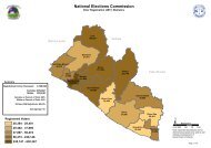
View map - National Elections Commission
View map - National Elections Commission
View map - National Elections Commission

You also want an ePaper? Increase the reach of your titles
YUMPU automatically turns print PDFs into web optimized ePapers that Google loves.
"<br />
03004<br />
Legend<br />
Five<br />
03070<br />
Four<br />
Tubmanburg City<br />
"<br />
"<br />
03071<br />
GRAND CAPE MT.<br />
NOTE: Administrative unit boundaries shown here do<br />
not represent official endorsement by the <strong>National</strong><br />
<strong>Elections</strong> <strong>Commission</strong> or the Government of Liberia.<br />
The process for the accurate demarcation and<br />
<strong>map</strong>ping of administrative units " is currently on-going.<br />
Upon completion of this process, the Government of<br />
Liberia shall release the official boundaries for<br />
administrative units of Liberia<br />
" Voter Registration Center<br />
County Boundary<br />
Electoral District Boundary<br />
Administrative District Boundary<br />
Amalgamated Area Boundary<br />
"<br />
"<br />
03072<br />
03069<br />
One<br />
03076<br />
"<br />
03075<br />
Three<br />
"<br />
Nine<br />
"<br />
"<br />
03067<br />
Six<br />
03068<br />
"<br />
Eight<br />
03074<br />
Two<br />
Seven<br />
GRAND CAPE MOUNT<br />
Golodee<br />
³<br />
Zamian<br />
"<br />
"<br />
03049<br />
"<br />
03009<br />
"<br />
Besao<br />
03006<br />
Malema<br />
Senjeh<br />
03008<br />
"<br />
03042<br />
Barmo<br />
"<br />
03023<br />
Sackie<br />
"<br />
"<br />
"<br />
03003<br />
"<br />
Beafinie<br />
Gayah Hill<br />
03024<br />
Gohnzipo<br />
03005<br />
03002<br />
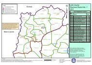
ED 1<br />
03001<br />
Baima<br />
"<br />
"<br />
03007<br />
Beajah "<br />
03004<br />
Sieh<br />
"<br />
03018<br />
Five<br />
Nine 03074<br />
03076 "<br />
"<br />
03072 " Seven<br />
03075<br />
03070 "<br />
" Six03068<br />
" "<br />
03071 " Three<br />
Four 03069<br />
Two<br />
"<br />
03047<br />
"<br />
One<br />
Weakama<br />
Guie<br />
Bola<br />
Eight<br />
03067<br />
Klay<br />
GBARPOLU<br />
Zordee<br />
Maher<br />
"<br />
Gogehn<br />
03073<br />
Kowadee<br />
Julijuah<br />
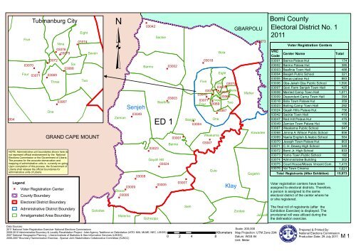
Bomi County<br />
Electoral District No. 1<br />
2011<br />
VRC<br />
Code<br />
Voter Registration Centers<br />
Center Name Total<br />
03001 Baima Palava Hut 174<br />
03002 Barmo Palava Hut 385<br />
03003 Beafinie Town Hall 488<br />
03004 Beajah Public School 321<br />
03005 Besao palava Hut 863<br />
03006 Gba-Jakeh Gba Public School 1,590<br />
03007 Govt. Farm Senjeh Town Hall 425<br />
03008 Married Camp Town Hall 1,071<br />
03009 Dependent Camp Town Hall 394<br />
03018 Bola Town Palava Hut 359<br />
03023 Boiling Camp Town Hall 292<br />
03024 Gayah Hills Palava Hut 756<br />
03042 Sackie Town Hall 419<br />
03047 Red Hill Palava Hut 475<br />
03049 Zamian Town Palava Hut 156<br />
03067 Weakama Public School 647<br />
03068 Jimina A. Wilson Public School 856<br />
03069 Nyeila English & Arabic School 584<br />
03070 Joseph Town Palava Hut 803<br />
03071 C. H. Dewey High School 548<br />
03072 Bomi Jr. High School 833<br />
03073 Yomo Town Public School 192<br />
03074 Administrative Building 302<br />
03075 Court House/Moses Vincent Com. 1,419<br />
03076 Vai Town Cinema 1,621<br />
Total Registrants (After Exhibition)<br />
Voter registration centers have been<br />
assigned to electoral districts. Therefore,<br />
a person is assigned to the same<br />
electoral district of the center where he<br />
or she registered.<br />
The final roll of registrants (after the<br />
Exhibition Exercise) is displayed. The<br />
provisional roll was utilized during the<br />
the delineation exercise.<br />
15,973<br />
Data Sources:<br />
2011 <strong>National</strong> Voter Registration Exercise- <strong>National</strong> <strong>Elections</strong> <strong>Commission</strong>s<br />
2009-2010 Administrative Boundary & Locality Revalidation Project - Inter-Agency Taskforce on Delimitation (IATD: MIA, MLME, NEC, LISGIS)<br />
2007 <strong>National</strong> Geographic Planning - LIberia Institute of Statistics & Geo-Information Services (LISGIS)<br />
2006-2007 Boundary Harmonization Exercise - Special Joint Stakeholders Collaborative Committee (SJSCC)<br />
Kilometers<br />
0 2 4 8<br />
Scale: 200,000<br />
Map Projection: UTM Zone 29N<br />
Datum: WGS 84<br />
Unit: Meter<br />
Prepared & Printed By:<br />
<strong>National</strong> <strong>Elections</strong> <strong>Commission</strong><br />
Production Date: 29 July 2011<br />
M 1
³<br />
Legend<br />
NOTE: Administrative unit boundaries shown here do<br />
not represent official endorsement by the <strong>National</strong><br />
<strong>Elections</strong> <strong>Commission</strong> or the Government of Liberia.<br />
The process for the accurate demarcation and<br />
<strong>map</strong>ping of administrative units is currently on-going.<br />
Upon completion of this process, the Government of<br />
Liberia shall release the official boundaries for<br />
administrative units of Liberia<br />
GRAND CAPE MT.<br />
" Voter Registration Center<br />
County Boundary<br />
Electoral District Boundary<br />
Administrative District Boundary<br />
Amalgamated Area Boundary<br />
GRAND CAPE<br />
MOUNT<br />
03041<br />
"<br />
Manjama<br />
Vortor<br />
03045<br />
Atlantic Ocean<br />
"<br />
"<br />
03029<br />
Golodee<br />
"<br />
"<br />
Gbaigbon03025<br />
"<br />
03010<br />
Beh<br />
Dowein<br />
Zamian<br />
03040<br />
Malema<br />
Dagweh<br />
Besao<br />
Barmo<br />
Senjeh<br />
Weajor<br />
03028<br />
"<br />
Gohnzipo<br />
Beafinie<br />
Gayah Hill<br />
MONTSERRADO<br />
Baima<br />
"<br />
"<br />
"<br />
"<br />
03014<br />
03012<br />
Behsalee<br />
Leyan<br />
Sackie<br />
03011<br />
Beajah<br />
"<br />
"<br />
03043<br />
Sieh<br />
03013<br />
"<br />
Five<br />
Four<br />
03044<br />
Bola<br />
Three<br />
One<br />
Eight<br />
Nine<br />
Seven Maher<br />
Six<br />
"<br />
"<br />
Two<br />
"<br />
03032<br />
03031<br />
Guie<br />
03033<br />
Bowein<br />
Weakama<br />
Gonjeh<br />
Vincent<br />
Jenneh<br />
Data Sources:<br />
2011 <strong>National</strong> Voter Registration Exercise- <strong>National</strong> <strong>Elections</strong> <strong>Commission</strong>s<br />
2009-2010 Administrative Boundary & Locality Revalidation Project - Inter-Agency Taskforce on Delimitation (IATD: MIA, MLME, NEC, LISGIS)<br />
2007 <strong>National</strong> Geographic Planning - LIberia Institute of Statistics & Geo-Information Services (LISGIS)<br />
2006-2007 Boundary Harmonization Exercise - Special Joint Stakeholders Collaborative Committee (SJSCC)<br />
ED 2<br />
Klay<br />
03051<br />
Zordee "<br />
Julijuah<br />
03052<br />
"<br />
"<br />
03027<br />
03048<br />
Weawolo"<br />
Zohn Bamon<br />
Benda<br />
03039<br />
Kowadee<br />
03037<br />
"<br />
"<br />
03035<br />
Bonor<br />
03036<br />
Gogehn<br />
"<br />
"<br />
03026<br />
Zuwah<br />
GBARPOLU<br />
Suehn<br />
Kilometers<br />
0 2 4 8<br />
Gbojay<br />
Beyan<br />
Gbao<br />
Suehn Mecca<br />
Big Geveh<br />
Maloma<br />
Kpakla<br />
Sonodee<br />
Mecca<br />
Zalamu<br />
Moila<br />
Sonodee<br />
MONTSERRADO<br />
Scale: 250,000<br />
Map Projection: UTM Zone 29N<br />
Datum: WGS 84<br />
Unit: Meter<br />
Bomi County<br />
Electoral District No. 2<br />
2011<br />
VRC<br />
Code<br />
Voter Registration Centers<br />
Name<br />
Total<br />
03010 Beh Town Hall 849<br />
03011 Sass Town Public School 1,381<br />
03012 Barmon Palava Hut 636<br />
03013 Golodee Gayla Town Hall 971<br />
03014 Gbargbah Palava Hut 673<br />
03025 Gbaigbon Town Hall 439<br />
03026 Goghen Palava Hut 606<br />
03027 Jawajeh Palava Hut 636<br />
03028 Gohnzipo Town Hall 550<br />
03029 Golodee Lassana Pub. Sch. 578<br />
03031 Guie Town Hall 908<br />
03032 Managbokai Palava Hut 395<br />
03033 Domagbamatina palava Hut 297<br />
03035 FefehTown Public School 550<br />
03036 Geveh Fahnsee Palava Hut 230<br />
03037 Kowadee Palava Hut 121<br />
03039 Gbakendu Palava Hut 187<br />
03040 Malema Town Hall 1,050<br />
03041 Manjama Palava Hut 226<br />
03043 Klay Town Hall 1,937<br />
03044 Govt. Farm Klay Palava Hut 468<br />
03045 Vortor Town Palava Hut 366<br />
03048 Beajojo’s Clinic 637<br />
03051 Zordee Palava Hut 588<br />
03052 Monnoh Town Hall 458<br />
Total Registrants (After Exhibition)<br />
Voter registration centers have been<br />
assigned to electoral districts. Therefore,<br />
a person is assigned to the same<br />
electoral district of the center where he<br />
or she registered.<br />
The final roll of registrants (after the<br />
Exhibition Exercise) is displayed. The<br />
provisional roll was utilized during the<br />
the delineation exercise.<br />
15,737<br />
Prepared & Printed By:<br />
<strong>National</strong> <strong>Elections</strong> <strong>Commission</strong><br />
Production Date: 29 July 2011<br />
M 2
Golodee<br />
Zamian<br />
Malema<br />
Beh<br />
Gbaigbon<br />
Senjeh<br />
"<br />
Besao<br />
Weajor<br />
03046<br />
"<br />
Dagweh<br />
03022<br />
Beafinie<br />
Gayah Hill<br />
Gohnzipo<br />
Barmo<br />
Baima<br />
Behsalee<br />
Leyan<br />
03038<br />
"<br />
Atlantic Ocean<br />
"<br />
Bola<br />
Beajah<br />
Sieh<br />
"<br />
03020<br />
03030<br />
03021<br />
"<br />
03034<br />
Jenneh<br />
03017<br />
Bogbeh<br />
Eight<br />
Five Nine<br />
Eight Seven<br />
Six<br />
Four<br />
Maher<br />
Three Two<br />
"<br />
"<br />
"<br />
One<br />
Gonjeh<br />
Bowein<br />
Dowein<br />
Weakama<br />
Guie<br />
03016<br />
Vincent<br />
Klay<br />
Zordee<br />
Weawolo<br />
Zohn Bamon<br />
Benda<br />
"<br />
03015<br />
Julijuah<br />
03019<br />
Bonor<br />
Kowadee<br />
Gogehn<br />
03063<br />
"<br />
Zuwah<br />
"<br />
" 03066<br />
"<br />
Suehn<br />
GBARPOLU<br />
Gbojay<br />
"<br />
03057<br />
03064<br />
Beyan<br />
03053<br />
Gbao<br />
"<br />
" "<br />
"<br />
03056<br />
Kpakla<br />
03058<br />
Maloma<br />
03059<br />
"<br />
Big Geveh<br />
"<br />
03061<br />
"<br />
Moila<br />
03062<br />
ED " 3<br />
Mecca<br />
03054<br />
03065<br />
Zalamu<br />
Sonodee<br />
"<br />
03060<br />
Suehn Mecca<br />
NOTE: Administrative unit boundaries shown here do<br />
not represent official endorsement by the <strong>National</strong><br />
<strong>Elections</strong> <strong>Commission</strong> or the Government of Liberia.<br />
The process for the accurate demarcation and<br />
<strong>map</strong>ping of administrative units is currently on-going.<br />
Upon completion of this process, the Government of<br />
Liberia shall release the official boundaries for<br />
administrative units of Liberia<br />
"<br />
03055<br />
Legend<br />
Gabi<br />
MONTSERRADO<br />
" Voter Registration Center<br />
County Boundary<br />
Electoral District Boundary<br />
BONG<br />
Voter registration centers have been<br />
assigned to electoral districts. Therefore,<br />
a person is assigned to the same<br />
electoral district of the center where he<br />
or she registered.<br />
The final roll of registrants (after the<br />
Exhibition Exercise) is displayed. The<br />
provisional roll was utilized during the<br />
the delineation exercise.<br />
Administrative District Boundary<br />
Amalgamated Area Boundary<br />
Bomi County<br />
³Electoral District No. 3<br />
2011<br />
Voter Registration Centers<br />
VRC<br />
Name<br />
Code<br />
Total<br />
03015 Tulaymu Palava Hut 405<br />
03016 Demeh Palava Hut 1,928<br />
03017 Bogbeh Palava Hut 935<br />
03019 Bonor Town Palava Hut 401<br />
03020 Bowien Town Palava Hut 424<br />
03021 Jeon School 201<br />
03022 Dagbweh Town Hall 1,182<br />
03030 Gonjeh Palava Hut 407<br />
03034 Jenneh #3 Palava Hut 1,626<br />
03038 Gowein Palava Hut 361<br />
03046 Weajor Town Hall 931<br />
03050 Zohnbaimon Palava Hut 218<br />
03053 Quassia Town Palava Hut 151<br />
03054 Big Geveh Palava Hut 322<br />
03055 Gbai Palava Hut 231<br />
03056 Gbao Palava Hut 568<br />
03057 Gbojah Palava Hut 855<br />
03058 Kpakla Palava Hut 476<br />
03059 Maloma Palava Hut 240<br />
03060 Mecca Palava Hut 570<br />
03061 Moila Town Hall 432<br />
03062 Sonodee Town Hall 378<br />
03063 Alasala Palava Hut 904<br />
03064 Suehn Town Hall 880<br />
03065 Mulbah Town Hall 459<br />
03066 Zuwah Town Palava Hut 391<br />
Total Registrants (After Exhibition)<br />
15,876<br />
Data Sources:<br />
2011 <strong>National</strong> Voter Registration Exercise- <strong>National</strong> <strong>Elections</strong> <strong>Commission</strong>s<br />
2009-2010 Administrative Boundary & Locality Revalidation Project - Inter-Agency Taskforce on Delimitation (IATD: MIA, MLME, NEC, LISGIS)<br />
2007 <strong>National</strong> Geographic Planning - LIberia Institute of Statistics & Geo-Information Services (LISGIS)<br />
2006-2007 Boundary Harmonization Exercise - Special Joint Stakeholders Collaborative Committee (SJSCC)<br />
Kilometers<br />
0 2 4 8<br />
Scale: 270,000<br />
Map Projection: UTM Zone 29N<br />
Datum: WGS 84<br />
Unit: Meter<br />
Prepared & Printed By:<br />
<strong>National</strong> <strong>Elections</strong> <strong>Commission</strong><br />
Production Date: 29 July 2011<br />
M 3