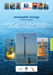
here - Hydrosphere UK Ltd.
here - Hydrosphere UK Ltd.
here - Hydrosphere UK Ltd.

You also want an ePaper? Increase the reach of your titles
YUMPU automatically turns print PDFs into web optimized ePapers that Google loves.
Moving towards<br />
e-Navigation<br />
The GLA strategy document<br />
“2025 & Beyond” was published<br />
in July 2011. This strategy is for a<br />
balanced mix of physical and radio<br />
aids to navigation (AtoN) that<br />
will meet the <strong>UK</strong>’s and Ireland’s<br />
SOLAS responsibilities and support<br />
the introduction of the imo’s<br />
e-Navigation project. But what is<br />
e-Navigation?<br />
The concept of e-Navigation<br />
is to integrate existing and new<br />
navigational tools, in particular<br />
electronic tools, in an all-embracing<br />
system that will contribute to<br />
enhanced navigational safety<br />
while simultaneously reducing the<br />
workload on the navigator. This<br />
concept covers not only the safe<br />
navigation of vessels, but also their<br />
efficiency, cost effectiveness and<br />
environmental impact.<br />
The technology to do this<br />
already exists: accurate positioning<br />
by satellite is well established<br />
through gps and glonass, while<br />
other systems such as compass<br />
are being developed.<br />
Systems, like Loran,<br />
are available to provide<br />
a complementary<br />
ground based accurate<br />
positioning capability.<br />
Accurate electronic<br />
navigational charts<br />
(enc) covering the<br />
majority of the world’s<br />
major shipping areas<br />
are readily available<br />
and a multiplicity<br />
of communications<br />
systems are available<br />
using ground based<br />
stations or satellites. The<br />
challenge is to put it all together into<br />
an integrated system with a target<br />
date of perhaps 2018. For the glas<br />
our challenge today is to adapt to<br />
this new world.<br />
For CIL this means a significant<br />
shift in the service provided.<br />
Lights of shorter range use high<br />
efficiency and high reliability light<br />
sources such as leds. The range of<br />
buoy lights may be increased in<br />
some areas with synchronisation<br />
to improve conspicuity. A Virtual<br />
AtoN deployed using ais provides<br />
an electronic version of an AtoN<br />
which is visible on encs/Radar<br />
while Racons further enable their<br />
identification on a radar display.<br />
dgps provides a virtual integrity<br />
warning and accuracy improvement<br />
for gps while eLoran can provide<br />
an independent complementary<br />
electronic positioning system.<br />
Fog signals are no longer classified<br />
as AtoNs and the remaining signals<br />
at Fastnet, Old Head of Kinsale,<br />
Roches Point, Ballycotton, Hook<br />
Haulbowline Lighthouse<br />
Seamus Doyle<br />
Head of Engineering<br />
Head, Tuskar Rock, Kish Tower,<br />
Dundalk and St John’s Point (Down)<br />
Lighthouses were withdrawn on<br />
11th January 2011.<br />
Despite ongoing financial<br />
pressures, our maintenance and<br />
project teams continue to maintain<br />
a busy schedule of maintenance,<br />
refurbishment and the replacement<br />
of obsolete equipment and systems.<br />
H aulbowline<br />
Haulbowline lighthouse was<br />
built after a request was made<br />
in 1817 to the Corporation for<br />
Preserving and Improving the<br />
Port of Dublin (the Ballast Board)<br />
by the merchants of Newry. The<br />
new light was to replace the 1803<br />
Cranfield Point Lighthouse due to<br />
the latter’s poor position in marking<br />
the dangerous rocks at the entrance<br />
to Carlingford Lough and also its<br />
inadequacy for the guiding of vessels<br />
at the west end of the Lough. A fixed<br />
white light was first exhibited on 1<br />
September 1824 and was changed to<br />
flashing in 1899.<br />
A fog signal was provided<br />
by a bell which was struck by<br />
a machine every 30 seconds<br />
during foggy weather. This<br />
was changed to an explosive<br />
fog signal in 1898 and to a<br />
pneumatic diaphone signal<br />
in 1932. The pneumatic fog<br />
signal was replaced with an<br />
electric signal in 1990 and was<br />
disestablished in January 2009.<br />
The station became unwatched<br />
automatic on 17th March 1965<br />
at which time the light was<br />
converted to electric. Following<br />
a complete re-equip in 1990, the<br />
station was powered by diesel<br />
driven generators with dual PRB46<br />
lanterns providing a 17 nm light<br />
during hours of darkness and in<br />
reduced visibility.<br />
Following improvements to<br />
the buoyage provided by Local<br />
Lighthouse Authorities in the<br />
vicinity, the revolving light at<br />
Haulbowline Lighthouse was<br />
discontinued on 16th July 2008.<br />
The station was converted to solar<br />
power in July 2011 and the existing<br />
lanterns were replaced with two<br />
tier VLB44 led 10nm lights. Power<br />
is provided by a solar array of four<br />
12 volt 50 watt photovoltaic panels<br />
mounted on the tower balcony<br />
and charging a 12 volt 250 Ah lead<br />
acid battery. The Datac monitoring<br />
system was replaced with<br />
monitoring via ais. As Haulbowline<br />
is a Listed 1 Building, Listed<br />
Building Consent for the proposed<br />
works was required before work was<br />
allowed to commence.<br />
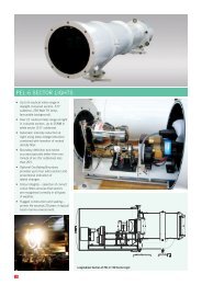
Castletownbere<br />
Directional Light<br />
The directional light and leading<br />
daymarks at Castletownbere provide<br />
guidance for ships entering the<br />
harbour of refuge or Dinnish Island.<br />
Plans to build a new road in front<br />
of the existing directional light<br />
necessitated the construction of a<br />
new directional light building on<br />
the seaward side of the new road to<br />
replace the front light structure. This<br />
provided an opportunity to up-date<br />
equipment and discontinue the rear<br />
mark. A new daytime/night-time<br />
directional light comprising a Vega<br />
PEL6 was installed in November<br />
2010 providing a night time range<br />
of 12 nm (Green and Red) and 15 nm<br />
(White) and a daytime range of 2 nm<br />
(Red and Green) and 4 nm (White).<br />
The station is mains powered with<br />
battery backup.<br />
V alentia<br />
Two unlighted beacons, were<br />
established on 20th January 1891 to<br />
guide vessels past the dangerous<br />
Harbour Rock at the northern<br />
entrance to Valentia Harbour during<br />
daylight. The beacons were lighted<br />
on 1st May 1913 using acetylene<br />
made in a carbide generator close<br />
to the lower front mark. Whilst they<br />
were unwatched, the Lightkeeper<br />
who was ashore<br />
from either<br />
Skelligs or<br />
Inishtearaght<br />
and living at the<br />
Knightstown<br />
dwellings,<br />
cleaned and<br />
charged the<br />
generator<br />
periodically.<br />
When the<br />
front light was<br />
converted to an electric direction<br />
light on 16th August 1967 the<br />
rear light mark was discontinued,<br />
however it was re-established on 9th<br />
March 1977.<br />
The equipment building at the<br />
front light at Valentia was made<br />
of timber lath and plaster and<br />
was no longer structurally sound.<br />
The building was replaced with a<br />
concrete structure in February 2011.<br />
At the same time, the leading lights<br />
were replaced with a daytime/night<br />
time directional sector light at the<br />
Front Light. The new night time<br />
range is 11 nm (White) and 8 nm<br />
(Green and Red), while the daytime<br />
Light range is 3 nm (White) and 2<br />
nm (Green and Red). The existing<br />
rear light and rear daymark were<br />
discontinued.<br />
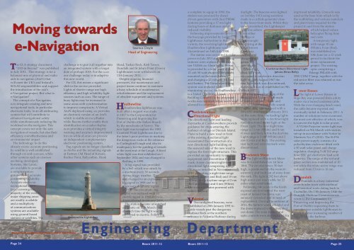
Castletownbere Directional Light<br />
(photo: Brian Kelly)<br />
Blackrock Mayo<br />
The light on Blackrock Mayo<br />
was first established on 1st June<br />
1864. The circular tower, 50 feet<br />
high, is positioned on the western<br />
extremity and built out of stone from<br />
the rock. The light is 282 feet above<br />
high water and was visible for 22<br />
miles when established.<br />
Following 146 years in the harsh<br />
exposed environment of the west<br />
coast of Ireland the dome was<br />
seriously corroded and in need of<br />
replacement. During the summer of<br />
2011, the lantern was scaffolded and<br />
the dome replaced with a moulded<br />
grp dome. The solar battery and<br />
optic controls were also replaced for<br />
improved reliability. Granuaile was<br />
used as the base from which to fly<br />
the scaffolding and various materials<br />
and plant items required for the<br />
project to and from the station<br />
which helped reduce<br />
helicopter flying time<br />
and costs.<br />
A temporary light,<br />
with range 10 nm<br />
(White), 8 nm (Red),<br />
was established on<br />
10th June for a 12 week<br />
period to facilitate the<br />
dome replacement<br />
project. The existing<br />
optic comprising a<br />
Pelangi PRL400 with<br />
35W CDM-T lamp, together with the<br />
red sector filter was retained as was<br />
the solar array.<br />
Lower Rosses<br />
The light at Lower Rosses in<br />
Sligo Bay was powered from utility<br />
mains via a buried undersea cable.<br />
With the ever changing beach sand,<br />
the cable became exposed and<br />
eventually failed in February 2011. A<br />
number of solutions were examined,<br />
the most cost effective of which, was<br />
to convert the light to solar power.<br />
A VLS46 Projector sector light was<br />
installed on 9th March with sectors<br />
set up in accordance with Notice to<br />
Mariners No.17 (2010). The SLP54<br />
solar power supply consists of a<br />
polyethylene enclosure fitted with<br />
a 50 watt solar panel and charge<br />
regulator, charging 3 off 110 amphour<br />
SEC gel electrolyte lead acid<br />
batteries. The range of the red and<br />
green sectors was maintained at 10<br />
nm while the white sector range was<br />
reduced from 13 nm to 10 nm.<br />
D undalk<br />
Dundalk is a busy industrial<br />
cross-border town with mythical<br />
and historical roots dating back to<br />
Cuchullin. On 13th January 1846 the<br />
Dundalk Harbour Commissioners<br />
wrote to the Corporation for<br />
Preserving and Improving the<br />
Port of Dublin requesting them to<br />
consider two suitable lighthouses to<br />
guide the ever increasing number of<br />
vessels into the harbour.<br />
Background: Loophead Lighthouse (photo: Kim Fahlen)<br />
Engineering<br />
Department<br />
Page 24<br />
Beam 2011-12 Beam 2011-12 Page 25
After a number of reminders, the<br />
construction of a lighthouse was<br />
approved. Two further approaches<br />
were made to the Board, one a<br />
reminder from Dundalk Harbour<br />
Commissioners and the other by<br />
Daniel O’Connell who was the<br />
MP for Dundalk at the time. The<br />
outcome was to erect<br />
a Mitchell’s Patent<br />
Screw Pile structure<br />
which would be<br />
similar to but smaller<br />
than the one then<br />
proposed for the<br />
Kish Bank.<br />
Alexander Mitchell<br />
was a blind Belfast<br />
engineer who had<br />
patented a wrought<br />
and cast-iron screw<br />
pile. A contract was<br />
placed with him in<br />
August 1848 to construct a lighthouse<br />
at the entrance to Dundalk, based<br />
on piles screwed into the sand and<br />
supporting a wooden decking on<br />
which was placed limited wooden<br />
accommodation and a small lantern.<br />
The new light, 33 feet above high<br />
water, comprising a fourth order<br />
dioptric white light with red<br />
sectors flashing every 15 seconds,<br />
was established on 18th June 1855.<br />
The cost to the end of 1855 was<br />
£6,769:4s:9d. A fog signal bell was<br />
established in November 1860.<br />
In December 1968 the light and<br />
fog signal were electrified using<br />
an underwater buried utility<br />
mains cable from shore. A further<br />
equipment upgrade was carried out<br />
in 2002.<br />
Due to a reduction in traffic the<br />
station was simplified in June 2011.<br />
The rotating lens PRL400 optic was<br />
replaced with an ML300 light fitted<br />
with a Maxi Halo 60 Eff led Flasher<br />
with range reduction from 21 nm<br />
to 10 nm. The emergency lights,<br />
fog detector and Datac rcms were<br />
also removed. Mains power supply<br />
via a buried underwater cable was<br />
retained though, with the reduced<br />
energy demand, the size of the<br />
battery was reduced.<br />
Bouys<br />
In an e-Navigation world, buoy<br />
lights continue to be an important<br />
Aid to Navigation and a number<br />
of changes have been made to<br />
improve performance and align buoy<br />
AtoN with the envisaged needs of<br />
e-Navigation. The Horseshoe buoy<br />
off Wicklow Head and the No1<br />
and No2 Glassgorman buoys, just<br />
south of Arklow, were repositioned<br />
as recommended in the Aids to<br />
Navigation Review 2010-2015. The<br />
South Long buoy, off<br />
Wexford, was moved<br />
1.5 cables to south west,<br />
changed from a south<br />
cardinal to starboard<br />
lateral and synchronised<br />
with the Splaugh buoy<br />
while further south, the<br />
height of the daymark<br />
on the South Rock buoy<br />
was increased to improve<br />
conspicuity.<br />
Top: VLS46 Projector Lights<br />
at Lower Rosses Point<br />
(photo: P. Lawlor)<br />
Bottom: Dundalk Pile Light<br />
(photo: D. Byrne)<br />
At the entrance to the Shannon,<br />
the Kilcreduane Buoy was changed<br />
to a port lateral mark and its light<br />
synchronised with the Tail of Beal<br />
Buoy in June 2011 which was<br />
changed to a starboard lateral mark.<br />
At the same time the Beal Spit Buoy<br />
was changed to a starboard lateral<br />
mark and its light synchronised with<br />
the Carrigaholt Buoy. This provides<br />
two “gates” marking the deep<br />
channel. Kilcredaune lighthouse<br />
navigational light was switched off<br />
permanently on the 11th March 2011.<br />
On the North Coast, a port hand<br />
lateral buoy, equipped with an 5 nm<br />
light and ais, was established on a<br />
new buoy station at Skerries, 0.5 nm<br />
NNE of the large Skerries Island near<br />
Portrush, on 25th August 2011.<br />
B eacons<br />
A red can topmark was<br />
established on the North Rocks<br />
beacon on 16th July 2011. The new<br />
topmark comprises a stainless steel<br />
structure secured to the top of the<br />
beacon and equipped with flexible<br />
polyethylene wings. This was a<br />
challenging project, ably completed<br />
by combined engineering and marine<br />
teams.<br />
Monitoring Centre<br />
The introduction of centralised<br />
remote monitoring and control<br />
started in the late 1980s with the<br />
introduction of the Datac monitoring<br />
system. Initially centralised<br />
monitoring was carried out as<br />
part of the Security Officer role<br />
in Dun Laoghaire. With on-going<br />
automation and demanning of major<br />
stations, a dedicated 24/7 Monitoring<br />
Centre manned by a team of<br />
Telemetry & Security Officers<br />
(tso) was established in 1993. This<br />
quickly became the nerve centre for<br />
monitoring and reporting from the<br />
coast, providing a first class service.<br />
All stations reported to the<br />
Monitoring Centre automatically<br />
four times per day though with<br />
immediate reporting of alarms<br />
requiring attention. A command<br />
facility enables lighthouse systems to<br />
be controlled by the tso so that AtoN<br />
outages can be avoided or corrected<br />
promptly t<strong>here</strong>by removing the<br />
requirement for an immediate visit<br />
to station. The tso was also the out of<br />
hours central telephone contact point<br />
for the public and outside Agencies.<br />
Maintenance operations support for<br />
technicians and Attendants on the<br />
coast and security was also provided<br />
by the tso.<br />
Improvements in equipment<br />
reliability, maintenance techniques<br />
and computer communications<br />
provided an opportunity to<br />
streamline this service. Using<br />
modern digital communications,<br />
Monitoring Officers in the Trinity<br />
House Operations and Planning<br />
Centre (opc) in Harwich were<br />
provided with access to the CIL<br />
Datac Central System and ais<br />
monitoring in Dun Laoghaire to<br />
enable them monitor critical alarms<br />
and AtoN outages. The dgps already<br />
had capability for monitoring in th.<br />
Multiple redundant communications<br />
pathways were configured between<br />
CIL and th to allow for the<br />
encrypted rcms data feeds.<br />
Under a<br />
Service Level<br />
Agreement, opc<br />
use this system<br />
to monitor<br />
CIL critical<br />
alarms outside<br />
of business<br />
hours t<strong>here</strong>by<br />
enabling the<br />
discontinuation<br />
of the 24/7<br />
shift working<br />
arrangement in<br />
Dun Laoghaire.<br />
During normal<br />
office hours, the<br />
tso continues<br />
to deal with<br />
all aspects of<br />
monitoring and<br />
reporting as<br />
<strong>here</strong>tofore. The project to transfer<br />
CIL ‘out of hours’ critical alarm<br />
monitoring to Harwich opc went<br />
operational on 1st July 2011.<br />
Light Intensity Tests<br />
Light intensity tests are carried<br />
out annually by gla R&RNav<br />
lights specialists to test or verify<br />
optic performance. The objective<br />
is to confirm the published range<br />
of recently changed Navigational<br />
Lights and to test proposed optic<br />
arrangements for some of the<br />
forthcoming re-equip projects.<br />
Recent tests have confirmed<br />
the performance of the lights at<br />
Howth, St John’s Point Down,<br />
Dunree, Inishowen, and Achillbeg<br />
Lighthouses.<br />
Mizen Head<br />
CIL has had a long association<br />
with the Mizen Head footbridge,<br />
having constructed the original<br />
footbridge 1908/09 to provide access<br />
across the deep gorge. Throughout<br />
the 100 year life of the bridge, it has<br />
been subject to extreme weather and<br />
environmental conditions. These<br />
conditions slowly took their toll<br />
and caused serious deterioration<br />
of the structure. The last issue of<br />
Beam contained a report on the<br />
North Rocks Beacon<br />
(photo: K. Whitney)<br />
construction of the new footbridge<br />
which was opened to the public on<br />
17th March 2011.<br />
The Engineers Ireland Excellence<br />
Awards showcase Irish engineering<br />
at its best. T<strong>here</strong> are several award<br />
categories<br />
culminating with<br />
the announcement<br />
of the Engineering<br />
Project of the<br />
Year. Engineering<br />
projects<br />
throughout<br />
Ireland were<br />
shortlisted<br />
by an expert<br />
judging panel<br />
and the winning<br />
Engineering<br />
Project of the<br />
Year is selected<br />
through an<br />
online public<br />
vote. At the 2011<br />
Engineers Ireland<br />
Excellence Awards<br />
held on 4th<br />
November 2011, the new Mizen<br />
Head Footbridge won the premier<br />
award as Engineering Project of the<br />
Year.<br />
The Mizen Head Footbridge<br />
project also won a second award for<br />
the Best Paper or Presentation of the<br />
Year. The Mizen Head Project was<br />
a collaborative effort between Irish<br />
Lights and Cork County Council<br />
with funding support from Fáilte<br />
Ireland.<br />
Loop Head<br />
As the need for accommodation<br />
at lighthouses decreases, houses<br />
become available for sale or<br />
alternative use. Successful<br />
alternative use projects like Hook<br />
Heritage, Mizen Vision and the Irish<br />
Landmark Trust houses provide<br />
encouragement that the valuable<br />
heritage of lighthouse stations can<br />
live.<br />
Under a Licence Agreement, Clare<br />
County Council arranged visitor<br />
access to Loop Head lighthouse<br />
tower during Summer 2011 in order<br />
to gauge interest from visitors in<br />
the area. Limited visitor facilities<br />
were provided in one of the old<br />
Lightkeepers houses and guided<br />
tours of the lighthouse tower were<br />
provided. The Council reported a<br />
highly successful period with very<br />
positive comments.<br />
Work in progress<br />
The present economic<br />
climate has necessitated a review of<br />
methods of both provision of AtoN<br />
and maintenance practices. With a<br />
focus on AtoN provision and future<br />
e-Navigation services, a review of<br />
all stations is being carried out to<br />
minimise operating costs through<br />
consolidation to the minimum<br />
station footprint and equipment<br />
simplification.<br />
Major re-equip projects at Tory<br />
Island, Roancarrig, Skellig Rock, Bull<br />
Rock, Achillbeg and Eagle Island<br />
are in progress. Obsolete Racons are<br />
being replaced and the roll out of the<br />
ais programme continues.<br />
Storm damage repairs, routine and<br />
breakdown maintenance, painting<br />
and building operations continue<br />
to be carried out to ensure that CIL<br />
not only meet iala AtoN availability<br />
targets but also ensure that our<br />
structures, buildings and heritage<br />
are maintained in a cost effective and<br />
efficient manner.<br />
This programme of work could not<br />
be achieved without the dedication,<br />
enthusiasm and hard work of<br />
the members of the Engineering<br />
Team. T<strong>here</strong> are too many people<br />
to mention individually; however,<br />
to the Design Engineers, members<br />
of the Drawing Office Team,<br />
Maintenance, Dun Laoghaire,<br />
Planning and Project Teams,<br />
Operations Administration Team<br />
and the Civil Team, both in Dun<br />
Laoghaire and on the Coast, I would<br />
like to thank each and every one of<br />
you for the part you played.<br />
This is my last Engineering report<br />
following my retirement on 29th<br />
February after 28 years with Irish<br />
Lights. As you can imagine the<br />
Service has undergone significant<br />
change during my time and, in some<br />
instances, is barely recognisable<br />
from what it was when I first joined.<br />
The coming years will see further<br />
significant changes as we position<br />
the Service to face the challenges that<br />
lie ahead.<br />
I would like to thank you all for<br />
the help and friendship that I have<br />
enjoyed during my time in Irish<br />
Lights and to wish you all the very<br />
best in the years ahead.<br />
Page 26<br />
Beam 2011-12 Beam 2011-12 Page 27